https://twitter.com/yconsor/status/1285993767649124352
ATL: GONZALO - Models
Moderator: S2k Moderators
-
jconsor
- Professional-Met

- Posts: 533
- Joined: Mon Jun 30, 2008 9:31 pm
- Location: Jerusalem, Israel
- Contact:
Re: ATL: GONZALO - Models
1 likes
-
Astromanía
- Category 2

- Posts: 737
- Age: 25
- Joined: Sat Aug 25, 2018 10:34 pm
- Location: Monterrey, N.L, México
Re: ATL: GONZALO - Models
supercane4867 wrote:12z CMC track is almost identical to Emily 05
Oh no, so México could be on the target
0 likes
-
HurricaneFrances04
- Category 2
- Posts: 595
- Joined: Mon Jun 25, 2012 8:09 am
- Location: Fort Lauderdale, Florida

-
supercane4867
- Category 5

- Posts: 4966
- Joined: Wed Nov 14, 2012 10:43 am
Re: ATL: GONZALO - Models
Both HWRF and HMON do show a weakening phase once the hurricane enters Eastern Caribbean, but it appears to be temporary and more than likely that it will stay intact as a TC.
0 likes
Re: ATL: SEVEN - Models
Aric Dunn wrote:Global Models are just having a seriously hard time with everything this year..
maybe they can tone down the SAL parameter and the Climatology parameter lol
What is the reason for such short-term model inaccuracy as of late?
0 likes
Andrew (1992), Irene (1999), Frances (2004), Katrina (2005), Wilma (2005), Fay (2008), Irma (2017), Eta (2020), Ian (2022)
-
gatorcane

- S2K Supporter

- Posts: 23499
- Age: 46
- Joined: Sun Mar 13, 2005 3:54 pm
- Location: Boca Raton, FL
Re: ATL: GONZALO - Models
The 12Z Euro looks to just about dissipate this before it reaches the islands likely due to high wind shear and dry air. Looks like a weak area of vorticity.
Last edited by gatorcane on Wed Jul 22, 2020 1:20 pm, edited 2 times in total.
0 likes
-
northjaxpro

- S2K Supporter
- Posts: 8900
- Joined: Mon Sep 27, 2010 11:21 am
- Location: Jacksonville, FL
Re: ATL: GONZALO - Models
2 likes
NEVER, EVER SAY NEVER in the tropics and weather in general, and most importantly, with life itself!!
________________________________________________________________________________________
Fay 2008 Beryl 2012 Debby 2012 Colin 2016 Hermine 2016 Julia 2016 Matthew 2016 Irma 2017 Dorian 2019
________________________________________________________________________________________
Fay 2008 Beryl 2012 Debby 2012 Colin 2016 Hermine 2016 Julia 2016 Matthew 2016 Irma 2017 Dorian 2019
-
TheStormExpert

- Category 5
- Posts: 8487
- Age: 30
- Joined: Wed Feb 16, 2011 5:38 pm
- Location: Palm Beach Gardens, FL
Re: ATL: GONZALO - Models
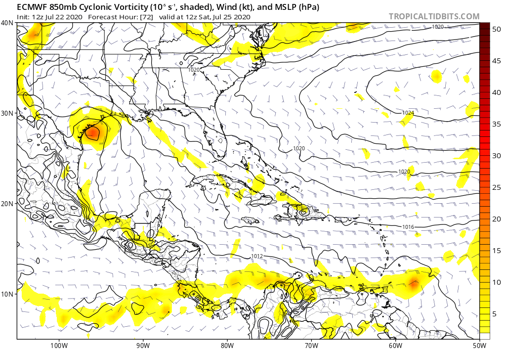
gatorcane wrote:The 12Z Euro looks to dissipate this before it reaches the islands likely due to high wind shear and dry air. Looks like a weak area of vorticity.
https://i.postimg.cc/wMsRs8ZZ/ecmwf-uv850-vort-watl-4.png
Some of you’ll are dismissing this storm too quickly.
2 likes
The following post is NOT an official forecast and should not be used as such. It is just the opinion of the poster and may or may not be backed by sound meteorological data. It is NOT endorsed by storm2k.org.

Re: ATL: GONZALO - Models
gatorcane wrote:The 12Z Euro looks to just about dissipate this before it reaches the islands likely due to high wind shear and dry air. Looks like a weak area of vorticity.
https://i.postimg.cc/wMsRs8ZZ/ecmwf-uv850-vort-watl-4.png
Models do not do well with small storms.
6 likes
The above post is not official and should not be used as such. It is the opinion of the poster and may or may not be backed by sound meteorological data. It is not endorsed by any professional institution or storm2k.org. For official information, please refer to the NHC and NWS products.
-
HurricaneFrances04
- Category 2
- Posts: 595
- Joined: Mon Jun 25, 2012 8:09 am
- Location: Fort Lauderdale, Florida
-
supercane4867
- Category 5
- Posts: 4966
- Joined: Wed Nov 14, 2012 10:43 am
Re: ATL: GONZALO - Models
The fact that 12z euro deepens 91L over 10mb inland just shows how off the global models have been this year.
1 likes
-
jconsor
- Professional-Met
- Posts: 533
- Joined: Mon Jun 30, 2008 9:31 pm
- Location: Jerusalem, Israel
- Contact:
Re: ATL: GONZALO - Models
Note: CTCX is the US Navy COAMPS model initialized with GFS initial conditions.
https://twitter.com/willkomaromi/status/1286001826521706496
https://twitter.com/willkomaromi/status/1286001826521706496
2 likes
-
Hurricaneman

- Category 5
- Posts: 7281
- Age: 43
- Joined: Tue Aug 31, 2004 3:24 pm
- Location: central florida
Re: ATL: GONZALO - Models
The 12zcanadian has this hitting Texas as a minimal hurricane at day 10, no other model has that solution but the GFS ensembles show something for Texas at day 10 so may have to watch this even if it falls apart in the eastern Caribbean especially in the western GOM
1 likes
-
Miami Storm Tracker

- Category 3

- Posts: 893
- Age: 66
- Joined: Sun Jun 13, 2010 10:12 pm
- Location: Key Largo, Fla.
- Contact:
Re: ATL: GONZALO - Models
Super-cane
Please help me to understand the difference between the two graphics. Both say 12Z and yes I see one goes out further in time, but the troubling thing I see is a storm sitting north of the Islands heading to the southern Bahamas not a track I wan to see. I thought Gonz was staying down south as they say a Caribbean Cruiser.
Please help me to understand the difference between the two graphics. Both say 12Z and yes I see one goes out further in time, but the troubling thing I see is a storm sitting north of the Islands heading to the southern Bahamas not a track I wan to see. I thought Gonz was staying down south as they say a Caribbean Cruiser.
0 likes

Re: ATL: GONZALO - Models
Hammy wrote:gatorcane wrote:The 12Z Euro looks to just about dissipate this before it reaches the islands likely due to high wind shear and dry air. Looks like a weak area of vorticity.
https://i.postimg.cc/wMsRs8ZZ/ecmwf-uv850-vort-watl-4.png
Models do not do well with small storms.
Dorian last year was probably the ultimate example of this ^
3 likes
Very useful information on the Dvorak Technique --
https://severe.worldweather.wmo.int/TCF ... kBeven.pdf
https://severe.worldweather.wmo.int/TCF ... kBeven.pdf
-
HurricaneFrances04
- Category 2
- Posts: 595
- Joined: Mon Jun 25, 2012 8:09 am
- Location: Fort Lauderdale, Florida
Re: ATL: GONZALO - Models
18Z GFS with another subtle shift north (now north of Barbados), and probably strongest run since the 00Z this morning.

0 likes
-
gatorcane
- S2K Supporter
- Posts: 23499
- Age: 46
- Joined: Sun Mar 13, 2005 3:54 pm
- Location: Boca Raton, FL
Re: ATL: GONZALO - Models
The GFS is stronger and more north on the 18Z run with strengthening in the Eastern Caribbean Sea. Quite a change:
Last edited by gatorcane on Wed Jul 22, 2020 5:09 pm, edited 1 time in total.
1 likes
-
ColdMiser123

- Professional-Met
- Posts: 778
- Age: 27
- Joined: Mon Sep 26, 2016 3:26 pm
- Location: Northeast US
Re: ATL: GONZALO - Models
GFS continuing the trend of a stronger storm on approach to the Lesser Antilles, which also allows for a slower system, and a more poleward trajectory while in the Caribbean. That increases separation between Gonzalo and the strong, extremely unfavorable low level wind flow in the Caribbean. This run of the GFS should show the farthest west Gonzalo has gotten yet.
0 likes
B.S., M.S., Meteorology & Atmospheric Science
-
HurricaneFrances04
- Category 2
- Posts: 595
- Joined: Mon Jun 25, 2012 8:09 am
- Location: Fort Lauderdale, Florida
Re: ATL: GONZALO - Models
18Z GFS so far very similar to the 12Z NAVGEM....
Edit: Unsurprisingly, loses the small storm over Haiti.
Edit: Unsurprisingly, loses the small storm over Haiti.
0 likes
-
supercane4867
- Category 5
- Posts: 4966
- Joined: Wed Nov 14, 2012 10:43 am
Re: ATL: GONZALO - Models
GFS is on collision course with Hispaniola. That would bring a swift death to this small system. It may regenerate later on tho.
0 likes
Who is online
Users browsing this forum: No registered users and 70 guests