ATL: TEN - Remnants - Discussion
Moderator: S2k Moderators

Re: ATL: INVEST 93L - Discussion
Of course it's not my call and the people at NHC have a lot more data to work with, but based on everything I've seen, including the sat images, I think it already looks classifiable. Guess we'll just have to wait to see what NHC will decide.
3 likes
-
AutoPenalti
- Category 5

- Posts: 3949
- Age: 27
- Joined: Mon Aug 17, 2015 4:16 pm
- Location: Ft. Lauderdale, Florida
Re: ATL: INVEST 93L - Discussion
Probably not as important at the moment, I’ve heard they tend to classify systems faster the closer to land (which seems reasonable)
0 likes
The posts in this forum are NOT official forecasts and should not be used as such. They are just the opinion of the poster and may or may not be backed by sound meteorological data. They are NOT endorsed by any professional institution or STORM2K. For official information, please refer to products from the NHC and NWS.
Model Runs Cheat Sheet:
GFS (5:30 AM/PM, 11:30 AM/PM)
HWRF, GFDL, UKMET, NAVGEM (6:30-8:00 AM/PM, 12:30-2:00 AM/PM)
ECMWF (1:45 AM/PM)
TCVN is a weighted averaged
-
captainbarbossa19

- Category 5
- Posts: 1039
- Joined: Wed Aug 21, 2019 11:09 pm
- Location: Starkville, MS
Re: ATL: INVEST 93L - Discussion
AutoPenalti wrote:Probably not as important at the moment, I’ve heard they tend to classify systems faster the closer to land (which seems reasonable)
I have seen other systems that were no where near land get classified and looked much worse than this. I think that is not the primary reason for not classifying the system. I think there are other reasons why this is not getting classified but I could not guess what they are.
1 likes
-
WeatherEmperor
- S2K Supporter

- Posts: 4806
- Age: 40
- Joined: Thu Sep 04, 2003 2:54 pm
- Location: South Florida
ATL: INVEST 93L - Discussion
Tropical Weather Outlook
NWS National Hurricane Center Miami FL
200 PM EDT Thu Jul 30 2020
For the North Atlantic...Caribbean Sea and the Gulf of Mexico:
The National Hurricane Center is issuing advisories on Tropical Storm Isaias, located over the northeastern Caribbean Sea.
Showers and thunderstorms associated with a small area of low pressure, located a few hundred miles south-southeast of the Cabo Verde Islands have increased and become better organized during the day. Environmental conditions appear conducive for further development, and this system could become a tropical depression during the next day or so while it drifts generally north-northwestward. After that time, environmental conditions are forecast to become less favorable for development. * Formation chance through 48 hours...medium...50 percent. * Formation chance through 5 days...medium...50 percent.
$$ Forecaster Roberts
Sent from my iPhone using Tapatalk
5 likes
Re: ATL: INVEST 93L - Discussion
That's a big jump in %, I think there's a pretty good big chance now that this one will be classified at some point.
0 likes

Re: ATL: INVEST 93L - Discussion
shiny-pebble wrote:Has there ever been a July where there was 3 deep tropic TC developments??
Sent from my SM-G970U using Tapatalk
For some weeks now, Mark Sudduth has occasionally been mentioning the possibility of this happening.
3 likes
-
Hypercane_Kyle

- Category 5
- Posts: 2899
- Joined: Sat Mar 07, 2015 7:58 pm
- Location: Cape Canaveral, FL
Re: ATL: INVEST 93L - Discussion
If named, this would beat Jose in 2005 for the earliest "J" storm by over 3 weeks.
5 likes
My posts are my own personal opinion, defer to the National Hurricane Center (NHC) and other NOAA products for decision making during hurricane season.
-
MGC

- S2K Supporter
- Posts: 5792
- Joined: Sun Mar 23, 2003 9:05 pm
- Location: Pass Christian MS, or what is left.
Re: ATL: INVEST 93L - Discussion
93L is spinning....could be upgraded soon with sufficient convection. CV islands need to be on guard....MGC
2 likes
-
tropicwatch

- Category 5
- Posts: 3205
- Age: 60
- Joined: Sat Jun 02, 2007 10:01 am
- Location: Panama City Florida
- Contact:
Re: ATL: INVEST 93L - Discussion
Doesn't look like many forecast models have latched onto this yet.
https://my.sfwmd.gov/sfwmd/common/images/weather/plots/storm_93.gif
https://my.sfwmd.gov/sfwmd/common/images/weather/plots/storm_93.gif
0 likes
Tropicwatch
Agnes 72', Eloise 75, Elena 85', Kate 85', Charley 86', Florence 88', Beryl 94', Dean 95', Erin 95', Opal 95', Earl 98', Georges 98', Ivan 2004', Arlene 2005', Dennis 2005', Ida 2009' Debby 2012' Irma 2017' Michael 2018'
Agnes 72', Eloise 75, Elena 85', Kate 85', Charley 86', Florence 88', Beryl 94', Dean 95', Erin 95', Opal 95', Earl 98', Georges 98', Ivan 2004', Arlene 2005', Dennis 2005', Ida 2009' Debby 2012' Irma 2017' Michael 2018'
-
Hurricaneman

- Category 5
- Posts: 7280
- Age: 43
- Joined: Tue Aug 31, 2004 3:24 pm
- Location: central florida
Re: ATL: INVEST 93L - Discussion
panamatropicwatch wrote:Doesn't look like many forecast models have latched onto this yet.
https://my.sfwmd.gov/sfwmd/common/images/weather/plots/storm_93.gif
The models haven’t done well this year so all you can do is go by the eye test as the models aren’t picking up on these systems
3 likes
-
EquusStorm

- Category 5
- Posts: 1649
- Age: 33
- Joined: Thu Nov 07, 2013 1:04 pm
- Location: Jasper, AL
- Contact:
Re: ATL: INVEST 93L - Discussion
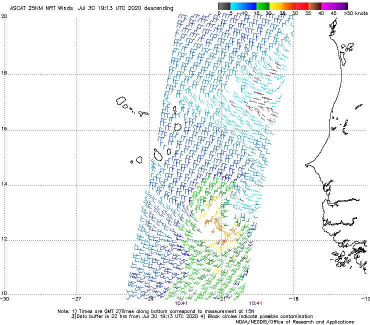
At least ASCAT isn't missing it today. Slightly open to NE may be why they didn't pull the trigger? I dunno. I think it is starting to lose organization and was probably closed earlier
5 likes
Colors of lost purpose on the canvas of irrelevance
Not a meteorologist, in fact more of an idiot than anything. You should probably check with the NHC or a local NWS office for official information.
Not a meteorologist, in fact more of an idiot than anything. You should probably check with the NHC or a local NWS office for official information.
-
CyclonicFury

- Category 5
- Posts: 1970
- Age: 25
- Joined: Sun Jul 02, 2017 12:32 pm
- Location: NC
- Contact:
Re: ATL: INVEST 93L - Discussion
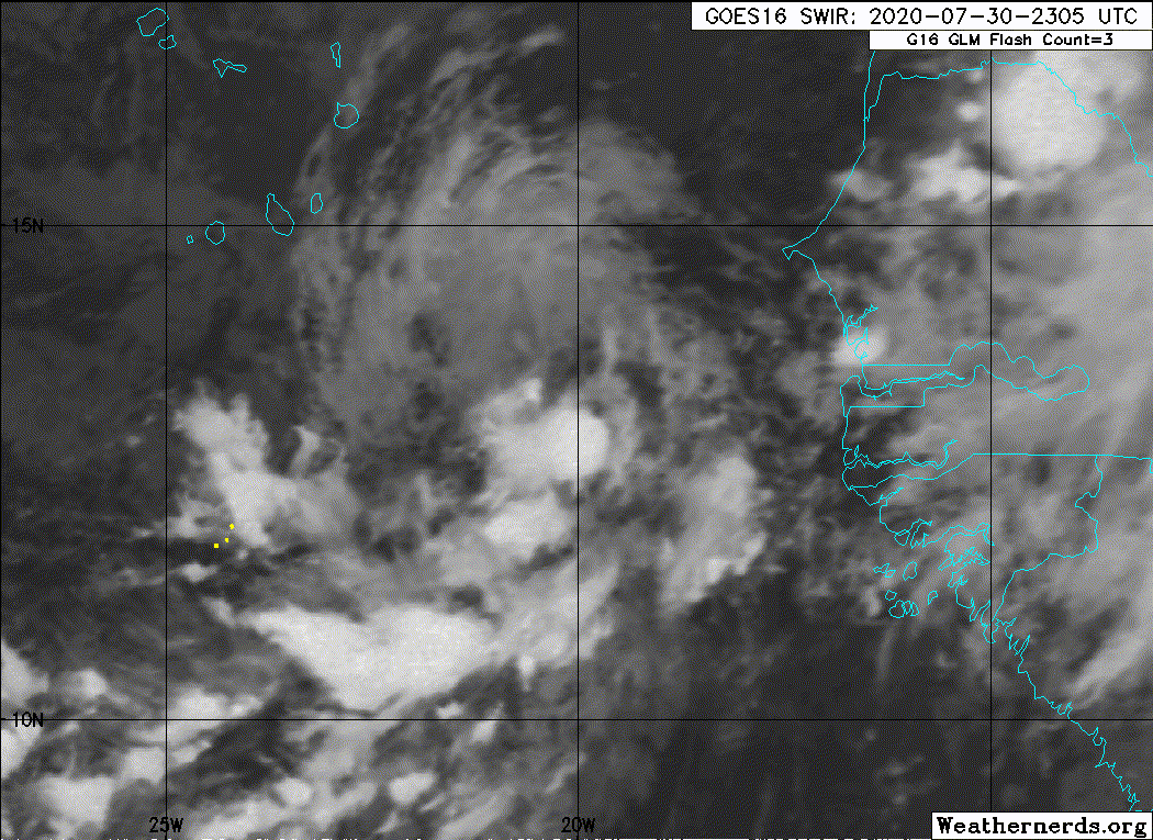
DMIN did a number on 93L. Convection significantly decreased near the center, though it has begun to redevelop SE of the center. In order to still get classified as a tropical depression, it will need to rebuild convection overnight.
1 likes
NCSU B.S. in Meteorology Class of 2021. Tropical weather blogger at http://www.cyclonicfury.com. My forecasts and thoughts are NOT official, for official forecasts please consult the National Hurricane Center.
-
cycloneye

- Admin

- Posts: 139008
- Age: 67
- Joined: Thu Oct 10, 2002 10:54 am
- Location: San Juan, Puerto Rico
Re: ATL: INVEST 93L - Discussion
A small area of low pressure is located about 250 miles southeast
of the Cabo Verde Islands. Shower and thunderstorm activity from
earlier in the day that was associated with a circulation in the
middle levels of the atmosphere has mostly dissipated, however
there is still some disorganized shower activity located near the
surface circulation center. This low has a small window of
opportunity to become a tropical depression through Friday while it
moves northward at about 10 mph, before environmental conditions
become less conducive for development.
* Formation chance through 48 hours...medium...40 percent.
* Formation chance through 5 days...medium...40 percent.
0 likes
Visit the Caribbean-Central America Weather Thread where you can find at first post web cams,radars
and observations from Caribbean basin members Click Here
and observations from Caribbean basin members Click Here


Re: ATL: INVEST 93L - Discussion
I'm still of the thinking that this was a TD for a decent chunk of time between last night and late this morning, but convection and organization have decreased since. Let's see if the upcoming Dmax can help it regain its footing and make a final push for classification.
0 likes

Re: ATL: INVEST 93L - Discussion
BobHarlem wrote:https://twitter.com/MikeAdcockWx/status/1289006628650602499
Was this issued after the chances were lowered?
0 likes
The above post is not official and should not be used as such. It is the opinion of the poster and may or may not be backed by sound meteorological data. It is not endorsed by any professional institution or storm2k.org. For official information, please refer to the NHC and NWS products.
-
Sciencerocks
- Category 5
- Posts: 7282
- Age: 38
- Joined: Thu Jul 06, 2017 1:51 am

Re: ATL: INVEST 93L - Discussion
I don't know why the NHC is taking so long, but this has checked all the boxes for a tropical cyclone for quite a while now. I guess Isaias is taking up the spotlight...
1 likes
-
bob rulz
- Category 5
- Posts: 1667
- Age: 34
- Joined: Sat Jan 28, 2006 7:30 pm
- Location: Salt Lake City, Utah
Re: ATL: INVEST 93L - Discussion
The NHC has simultaneously tracked 4+ storms before, so I don't really see why that would be an issue. I think they're just hesitant to designate storms right off the coast of Africa because of how quickly those big tropical waves can fall apart, especially with limited to no model support.
4 likes
Re: ATL: INVEST 93L - Discussion
bob rulz wrote:The NHC has simultaneously tracked 4+ storms before, so I don't really see why that would be an issue. I think they're just hesitant to designate storms right off the coast of Africa because of how quickly those big tropical waves can fall apart, especially with limited to no model support.
Personally, I think if it meets the requirements, it should be designated for consistency. What ends up happening is that a storm isn't designated even though it is like a TC, and then it falls apart when NHC waits too long. 93L has looked better than several other tropical depressions over the past day, and models have done a not-so-great job this year so far.
That being said, I'll defer to the experts on this - maybe they're seeing something we don't. 2020 might end up getting snubbed out of its record 6th July TC... I hope it doesn't try to beat 2005 in another way out of spite.
3 likes
Who is online
Users browsing this forum: No registered users and 14 guests