EP, 95, 2020081500, , BEST, 0, 101N, 865W, 20, 1007, DB, 34, NEQ, 0, 0, 0, 0, 1008, 150, 60, 0, 0, E, 0, , 0, 0, INVEST, S, 0, , 0, 0, 0, 0, genesis-num, 020, SPAWNINVEST, ep722020 to ep952020
EPAC: GENEVIEVE - Post-Tropical
Moderator: S2k Moderators
-
Nancy Smar

- Category 5

- Posts: 1081
- Age: 23
- Joined: Wed Aug 16, 2017 10:03 pm
EPAC: GENEVIEVE - Post-Tropical
Last edited by Nancy Smar on Mon Aug 17, 2020 7:59 am, edited 4 times in total.
0 likes


-
cycloneye

- Admin

- Posts: 139087
- Age: 67
- Joined: Thu Oct 10, 2002 10:54 am
- Location: San Juan, Puerto Rico
Re: EPAC: INVEST 95E
* GFS version *
* EAST PACIFIC 2020 SHIPS INTENSITY FORECAST *
* IR SAT DATA AVAILABLE, OHC AVAILABLE *
* INVEST EP952020 08/15/20 00 UTC *
TIME (HR) 0 6 12 18 24 36 48 60 72 84 96 108 120 132 144 156 168
V (KT) NO LAND 20 23 27 32 38 48 62 75 87 96 102 102 104 98 95 92 88
V (KT) LAND 20 23 27 32 38 48 62 75 87 96 102 102 104 98 95 92 88
V (KT) LGEM 20 21 21 23 24 28 34 42 52 65 79 93 97 91 80 69 60
Storm Type TROP TROP TROP TROP TROP TROP TROP TROP TROP TROP TROP TROP TROP TROP TROP TROP TROP
SHEAR (KT) 10 4 7 11 12 4 5 10 8 5 11 10 14 11 5 5 4
SHEAR ADJ (KT) 0 0 1 0 -4 0 -1 -1 0 -2 -1 0 2 2 4 6 12
SHEAR DIR 133 141 125 110 107 108 94 89 104 127 127 183 157 148 163 205 234
SST (C) 28.5 27.8 27.6 28.4 29.1 29.4 30.0 30.6 30.4 29.8 29.2 29.3 28.5 27.2 26.1 25.2 24.5
POT. INT. (KT) 151 144 141 149 156 160 166 173 171 164 158 158 150 136 124 115 108
200 MB T (C) -52.0 -52.5 -53.0 -52.7 -52.4 -53.3 -52.5 -53.0 -52.2 -52.7 -51.7 -52.3 -51.2 -51.4 -50.6 -50.7 -49.9
200 MB VXT (C) 0.0 0.1 0.1 0.1 0.1 0.1 0.2 0.3 0.3 0.4 0.4 0.6 0.6 1.1 1.2 1.4 1.1
TH_E DEV (C) 6 5 4 5 5 3 6 4 8 6 10 6 8 5 6 3 2
700-500 MB RH 75 76 79 78 80 79 79 80 83 81 77 71 66 62 59 59 54
MODEL VTX (KT) 9 9 9 12 13 15 19 20 22 26 30 30 33 30 30 27 25
850 MB ENV VOR 66 74 73 64 61 33 35 36 48 40 72 74 100 60 62 59 60
200 MB DIV 164 155 128 125 138 136 132 110 126 85 126 99 100 24 30 14 5
700-850 TADV 7 2 1 0 -1 1 2 -6 -5 -1 -2 0 0 -8 0 -2 3
LAND (KM) 67 230 327 349 377 422 413 333 290 212 161 213 174 160 221 336 431
LAT (DEG N) 10.1 10.1 10.2 10.4 10.6 11.1 12.0 13.2 14.7 16.4 18.2 20.0 21.4 xx.x xx.x xx.x xx.x
LONG(DEG W) 86.5 88.0 89.4 90.6 91.8 94.1 96.6 99.1 101.6 103.9 105.9 107.7 109.5 xxx.x xxx.x xxx.x xxx.x
STM SPEED (KT) 15 14 13 12 11 12 13 14 15 13 13 12 11 11 10 10 10
HEAT CONTENT 11 6 5 9 12 14 23 30 37 26 22 14 12 2 0 0 0
FORECAST TRACK FROM TABM INITIAL HEADING/SPEED (DEG/KT):270/ 15 CX,CY: -14/ 0
T-12 MAX WIND: 20 PRESSURE OF STEERING LEVEL (MB): 506 (MEAN=587)
GOES IR BRIGHTNESS TEMP. STD DEV. 50-200 KM RAD: 13.9 (MEAN=14.5)
% GOES IR PIXELS WITH T < -20 C 50-200 KM RAD: 72.0 (MEAN=65.0)
PRELIM RI PROB (DV .GE. 35 KT IN 36 HR): 27.9
INDIVIDUAL CONTRIBUTIONS TO INTENSITY CHANGE
6 12 18 24 36 48 60 72 84 96 108 120 132 144 156 168
------------------------------------------------------------------------------
SAMPLE MEAN CHANGE 0. 0. 1. 1. 1. 2. 1. 1. 0. -0. -1. -2. -3. -4. -4. -5.
SST POTENTIAL -0. -0. -0. 1. 5. 12. 20. 27. 32. 36. 40. 43. 45. 47. 47. 48.
VERTICAL SHEAR MAG 1. 2. 3. 3. 4. 5. 5. 6. 6. 6. 6. 6. 5. 6. 5. 6.
VERTICAL SHEAR ADJ 0. -0. 0. 0. 1. 1. 1. 1. 0. 0. -0. -0. -0. -0. 0. -0.
VERTICAL SHEAR DIR 0. 0. 1. 1. 3. 5. 6. 6. 6. 6. 5. 4. 3. 2. 2. 2.
PERSISTENCE -0. -0. -0. -1. -1. -1. -0. -0. -0. -0. -0. -0. -0. -0. -0. -0.
200/250 MB TEMP. -0. -0. -0. -1. -1. -1. -2. -2. -2. -2. -2. -1. 1. 2. 4. 5.
THETA_E EXCESS -0. -0. -0. -1. -2. -2. -3. -2. -2. -1. -1. -1. -1. -1. -2. -3.
700-500 MB RH 0. 0. 0. 1. 1. 1. 1. 2. 2. 2. 2. 2. 2. 2. 2. 3.
MODEL VTX TENDENCY -0. 0. 2. 3. 5. 10. 14. 18. 23. 28. 27. 29. 23. 20. 17. 13.
850 MB ENV VORTICITY 0. 0. 0. 0. 0. -0. -0. -0. -1. -1. -1. -1. -1. -1. -1. -1.
200 MB DIVERGENCE 0. 1. 2. 2. 2. 4. 6. 8. 9. 9. 9. 7. 5. 3. 1. 0.
850-700 T ADVEC -0. -0. -0. -0. -0. -0. 0. -0. 0. 0. 0. 0. -0. -0. -0. -0.
ZONAL STORM MOTION 0. 0. 1. 1. 2. 3. 3. 3. 2. 2. 2. 2. 2. 1. 1. -0.
STEERING LEVEL PRES -0. -0. -0. -1. -1. -1. -1. -1. -1. -1. -1. -2. -1. -1. -1. -0.
DAYS FROM CLIM. PEAK 0. 0. 0. 0. 0. 0. 1. 1. 2. 2. 2. 3. 3. 3. 4. 4.
GOES PREDICTORS 1. 2. 2. 2. 1. 0. -0. -1. -1. -2. -2. -2. -2. -2. -2. -2.
OCEAN HEAT CONTENT 0. -0. -0. -0. -0. -0. -0. 0. 0. 0. 0. -0. -0. 0. 0. 1.
RI POTENTIAL 1. 1. 3. 4. 6. 5. 3. 1. -0. -1. -2. -2. -2. -2. -2. -2.
------------------------------------------------------------------------------
TOTAL CHANGE 3. 7. 12. 18. 28. 42. 55. 67. 76. 82. 82. 84. 78. 75. 72. 68.
CURRENT MAX WIND (KT): 20. LAT, LON: 10.1 86.5
** 2020 E. Pacific RI INDEX EP952020 INVEST 08/15/20 00 UTC **
(SHIPS-RII PREDICTOR TABLE for 30 KT OR MOREMAXIMUM WIND INCREASE IN NEXT 24-h)
Predictor Value RI Predictor Range Scaled Value(0-1) % Contribution
POT = MPI-VMAX (KT) : 128.4 40.5 to 149.3 0.81 999.0
12 HR PERSISTENCE (KT) : 0.0 -22.0 to 44.0 0.33 999.0
850-200 MB SHEAR (KT) : 8.7 19.6 to 1.4 0.60 999.0
D200 (10**7s-1) : 142.0 -33.0 to 160.6 0.90 999.0
MAXIMUM WIND (KT) : 20.0 22.5 to 132.0 0.00 0.0
STD DEV OF IR BR TEMP : 13.9 37.8 to 2.1 0.67 999.0
HEAT CONTENT (KJ/CM2) : 8.6 2.7 to 106.7 0.06 999.0
BL DRY-AIR FLUX (W/M2) : 31.0 800.8 to -82.5 0.87 999.0
%area of TPW <45 mm upshear : 0.0 56.6 to 0.0 1.00 999.0
2nd PC OF IR BR TEMP : 0.4 2.2 to -1.9 0.43 999.0
SHIPS Prob RI for 20kt/ 12hr RI threshold= 0% is 0.0 times climatological mean ( 6.3%)
SHIPS Prob RI for 25kt/ 24hr RI threshold= 0% is 0.0 times climatological mean (12.6%)
SHIPS Prob RI for 30kt/ 24hr RI threshold= 0% is 0.0 times climatological mean ( 8.6%)
SHIPS Prob RI for 35kt/ 24hr RI threshold= 0% is 0.0 times climatological mean ( 6.2%)
SHIPS Prob RI for 40kt/ 24hr RI threshold= 0% is 0.0 times climatological mean ( 4.2%)
SHIPS Prob RI for 45kt/ 36hr RI threshold= 0% is 0.0 times climatological mean ( 6.7%)
SHIPS Prob RI for 55kt/ 48hr RI threshold= 0% is 0.0 times climatological mean ( 5.9%)
SHIPS Prob RI for 65kt/ 72hr RI threshold= 0% is 0.0 times climatological mean ( 4.7%)
Matrix of RI probabilities
------------------------------------------------------------------------------
RI (kt / h) | 20/12 | 25/24 | 30/24 | 35/24 | 40/24 | 45/36 | 55/48 |65/72
------------------------------------------------------------------------------
SHIPS-RII: 0.0% 0.0% 0.0% 0.0% 0.0% 0.0% 0.0% 0.0%
Logistic: 6.2% 49.3% 32.6% 22.4% 7.7% 63.4% 89.7% 86.6%
Bayesian: 0.0% 0.9% 0.6% 0.1% 0.0% 0.2% 1.1% 5.3%
Consensus: 2.1% 16.7% 11.1% 7.5% 2.6% 21.2% 30.3% 30.6%
DTOPS: 999.0% 999.0% 999.0% 999.0% 999.0% 999.0% 999.0% 999.0%
## ANNULAR HURRICANE INDEX (AHI) EP952020 INVEST 08/15/20 00 UTC ##
## STORM NOT ANNULAR, SCREENING STEP FAILED, NPASS=4 NFAIL=3 ##
## AHI= 0 (AHI OF 100 IS BEST FIT TO ANN. STRUC., 1 IS MARGINAL, 0 IS NOT ANNULAR) ##
0 likes
Visit the Caribbean-Central America Weather Thread where you can find at first post web cams,radars
and observations from Caribbean basin members Click Here
and observations from Caribbean basin members Click Here
-
cycloneye
- Admin
- Posts: 139087
- Age: 67
- Joined: Thu Oct 10, 2002 10:54 am
- Location: San Juan, Puerto Rico
Re: EPAC: INVEST 95E
Nancy Smar, I eliminated my posts to then yours be the leading one of thread. I reconize it was not the right thing to do but we are good now.
2 likes
Visit the Caribbean-Central America Weather Thread where you can find at first post web cams,radars
and observations from Caribbean basin members Click Here
and observations from Caribbean basin members Click Here
-
cycloneye
- Admin
- Posts: 139087
- Age: 67
- Joined: Thu Oct 10, 2002 10:54 am
- Location: San Juan, Puerto Rico
Re: EPAC: INVEST 95E
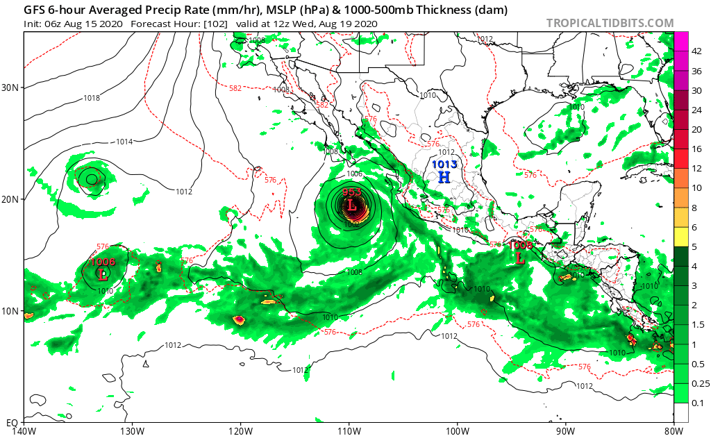
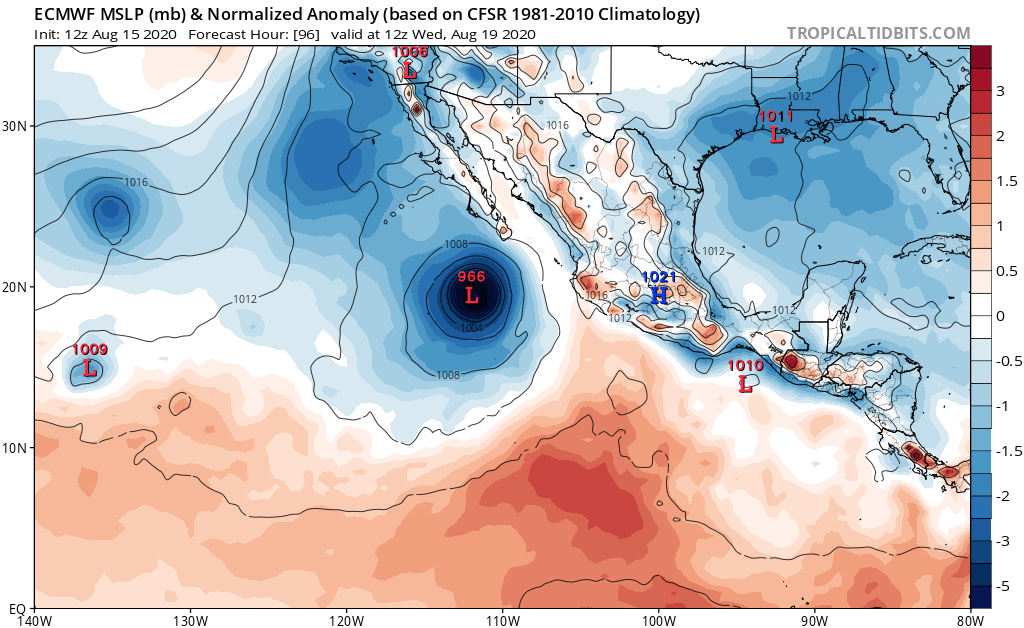
gatorcane wrote:18Z GFS at 126 hours down to 950MB:
https://i.postimg.cc/SRwjXCvq/gfs-mslp-pcpn-epac-21.png
As you said,it all depends on how far it moves from the Mexican coast to then be the big one of this basin.
0 likes
Visit the Caribbean-Central America Weather Thread where you can find at first post web cams,radars
and observations from Caribbean basin members Click Here
and observations from Caribbean basin members Click Here
-
Yellow Evan

- Professional-Met

- Posts: 15952
- Age: 25
- Joined: Fri Jul 15, 2011 12:48 pm
- Location: Henderson, Nevada/Honolulu, HI
- Contact:
Re: EPAC: INVEST 95E
This has one thing going for it. It's more likely to get going much faster than 93/94E.
2 likes

Re: EPAC: INVEST 95E
cycloneye wrote:gatorcane wrote:18Z GFS at 126 hours down to 950MB:
https://i.postimg.cc/SRwjXCvq/gfs-mslp-pcpn-epac-21.png
As you said,it all depends on how far it moves from the Mexican coast to then be the big one of this basin.
GFS and ECMWF runs have been pretty consistent over the last few days about 95E staying far enough off of the coast to bomb out. The GFS has been the most aggressive, being the GFS, but the Euro still produces at least a Cat 2 hurricane.
This will probably be the last notable storm in the EPac before the Atlantic takes over next week.
0 likes
Irene '11 Sandy '12 Hermine '16 5/15/2018 Derecho Fay '20 Isaias '20 Elsa '21 Henri '21 Ida '21
I am only a meteorology enthusiast who knows a decent amount about tropical cyclones. Look to the professional mets, the NHC, or your local weather office for the best information.
I am only a meteorology enthusiast who knows a decent amount about tropical cyclones. Look to the professional mets, the NHC, or your local weather office for the best information.
-
cycloneye
- Admin
- Posts: 139087
- Age: 67
- Joined: Thu Oct 10, 2002 10:54 am
- Location: San Juan, Puerto Rico
Re: EPAC: INVEST 95E
Cabo San Lucas will have a close call.

Look at the intensity models.

Look at the intensity models.
0 likes
Visit the Caribbean-Central America Weather Thread where you can find at first post web cams,radars
and observations from Caribbean basin members Click Here
and observations from Caribbean basin members Click Here
Re: EPAC: INVEST 95E
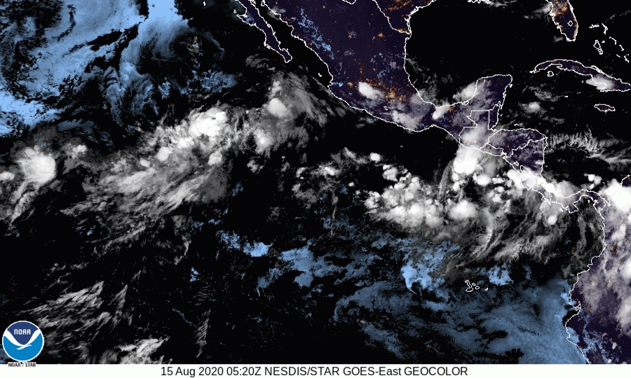
This one actually does have a pretty good satellite signature right now with some deep convection and healthy spin. I’m feeling slightly hopeful in regards to intensity. I think it might have a legitimate shot at Cat 2/3. We’ll see though, this season has been full of disappointment.
1 likes
Solar Aquarian
Lunar Cancerian
 Sagittarian
Lunar Cancerian
-
DorkyMcDorkface

- Category 2

- Posts: 698
- Age: 26
- Joined: Mon Sep 30, 2019 1:32 pm
- Location: Mid-Atlantic
Re: EPAC: INVEST 95E
Definitely think this is the EPAC's best shot at another major out of all the storms in this outbreak. 10E is struggling, 93E probably won't amount to anything and 94E looks like it'll be a moderate TS at the very most. This will have by far the most time and the most favorable environment out of all of them, and models are clearly latching on to this.
0 likes
Floyd 1999 | Isabel 2003 | Hanna 2008 | Irene 2011 | Sandy 2012 | Isaias 2020
-
AxaltaRacing24
- Category 5
- Posts: 1709
- Age: 23
- Joined: Wed Jul 27, 2016 11:14 am
- Location: Jupiter, FL
Re: EPAC: INVEST 95E
DorkyMcDorkface wrote:Definitely think this is the EPAC's best shot at another major out of all the storms in this outbreak. 10E is struggling, 93E probably won't amount to anything and 94E looks like it'll be a moderate TS at the very most. This will have by far the most time and the most favorable environment out of all of them, and models are clearly latching on to this.
yep. this is the storm to do it, if any of them are going to.
0 likes
-
Kingarabian

- S2K Supporter

- Posts: 15435
- Joined: Sat Aug 08, 2009 3:06 am
- Location: Honolulu, Hawaii
Re: EPAC: INVEST 95E
I think this will barely muster Cat.2 and that's me being generous. Prove me wrong, EPAC.
2 likes
RIP Kobe Bryant
-
cycloneye
- Admin
- Posts: 139087
- Age: 67
- Joined: Thu Oct 10, 2002 10:54 am
- Location: San Juan, Puerto Rico
Re: EPAC: INVEST 95E
Showers and thunderstorms associated with a trough of low pressure
located several hundred miles southeast of the Gulf of Tehuantepec
are beginning to show signs of organization. Conditions appear
conducive for further development and a tropical depression or
tropical storm is likely to form later this weekend or early next
week while the system moves generally west-northwestward just
offshore of the southwestern coast of Mexico.
* Formation chance through 48 hours...high...80 percent.
* Formation chance through 5 days...high...90 percent.
0 likes
Visit the Caribbean-Central America Weather Thread where you can find at first post web cams,radars
and observations from Caribbean basin members Click Here
and observations from Caribbean basin members Click Here
-
cycloneye
- Admin
- Posts: 139087
- Age: 67
- Joined: Thu Oct 10, 2002 10:54 am
- Location: San Juan, Puerto Rico
Re: EPAC: INVEST 95E
SHIP has it up to cat 3.
* EAST PACIFIC 2020 SHIPS INTENSITY FORECAST *
* IR SAT DATA AVAILABLE, OHC AVAILABLE *
* INVEST EP952020 08/15/20 12 UTC *
TIME (HR) 0 6 12 18 24 36 48 60 72 84 96 108 120 132 144 156 168
V (KT) NO LAND 25 29 34 40 48 61 74 86 98 105 106 103 102 94 86 79 71
V (KT) LAND 25 29 34 40 48 61 74 86 98 105 106 103 102 94 86 79 71
V (KT) LGEM 25 27 30 33 36 44 54 68 86 103 107 103 92 77 61 49 37
Storm Type TROP TROP TROP TROP TROP TROP TROP TROP TROP TROP TROP TROP TROP TROP TROP TROP TROP
SHEAR (KT) 7 11 11 7 7 3 4 7 3 8 8 9 7 9 10 13 17
SHEAR ADJ (KT) 1 0 -1 0 3 0 0 -2 0 -2 -1 2 6 9 7 11 4
SHEAR DIR 119 113 74 61 35 54 86 88 126 142 206 165 172 183 199 188 192
SST (C) 28.0 28.9 28.9 29.1 29.4 29.5 29.9 30.1 30.9 29.3 29.1 28.1 27.0 25.4 23.9 22.2 21.3
POT. INT. (KT) 146 155 154 156 160 161 166 168 173 159 156 146 135 119 103 85 74
200 MB T (C) -52.9 -52.7 -52.4 -52.9 -53.1 -52.5 -53.1 -52.2 -52.6 -51.9 -52.3 -51.1 -51.4 -50.5 -50.5 -50.1 -50.0
200 MB VXT (C) 0.1 0.1 0.1 0.1 0.1 0.1 0.2 0.3 0.4 0.4 0.6 0.6 1.1 1.0 1.3 1.2 1.1
TH_E DEV (C) 4 4 4 3 3 5 4 8 7 10 7 9 5 5 1 0 0
700-500 MB RH 79 79 81 80 79 81 80 81 82 79 74 65 60 54 58 54 53
MODEL VTX (KT) 10 11 12 13 16 19 20 22 26 29 31 29 31 27 24 21 18
850 MB ENV VOR 75 67 57 44 41 35 25 24 25 63 64 87 50 33 54 33 29
200 MB DIV 127 132 123 123 134 134 99 117 91 125 89 53 7 0 -7 11 10
700-850 TADV 2 0 -3 -1 -2 3 -2 -7 -5 0 1 -3 -10 4 -2 -5 -4
LAND (KM) 404 470 489 515 555 500 440 389 290 208 240 119 101 192 275 437 546
LAT (DEG N) 9.7 9.7 9.9 10.1 10.4 11.4 12.6 14.2 16.1 18.2 20.3 21.9 23.4 xx.x xx.x xx.x xx.x
LONG(DEG W) 90.2 91.7 92.9 94.0 95.2 97.8 100.2 102.7 104.8 106.5 108.0 109.6 111.7 xxx.x xxx.x xxx.x xxx.x
STM SPEED (KT) 15 13 11 12 13 13 14 14 14 13 11 12 13 14 14 12 9
HEAT CONTENT 7 12 10 11 14 17 35 42 35 22 13 8 2 0 0 0 0
FORECAST TRACK FROM TABM INITIAL HEADING/SPEED (DEG/KT):270/ 15 CX,CY: -14/ 0
T-12 MAX WIND: 20 PRESSURE OF STEERING LEVEL (MB): 469 (MEAN=587)
GOES IR BRIGHTNESS TEMP. STD DEV. 50-200 KM RAD: 17.5 (MEAN=14.5)
% GOES IR PIXELS WITH T < -20 C 50-200 KM RAD: 79.0 (MEAN=65.0)
PRELIM RI PROB (DV .GE. 35 KT IN 36 HR): 42.0
INDIVIDUAL CONTRIBUTIONS TO INTENSITY CHANGE
6 12 18 24 36 48 60 72 84 96 108 120 132 144 156 168
------------------------------------------------------------------------------
SAMPLE MEAN CHANGE 0. 0. 1. 1. 1. 2. 1. 1. 0. -0. -1. -2. -3. -4. -4. -5.
SST POTENTIAL -0. -0. -0. 1. 5. 12. 19. 25. 30. 33. 36. 39. 40. 40. 39. 37.
VERTICAL SHEAR MAG 1. 1. 2. 3. 4. 5. 6. 7. 7. 7. 7. 8. 8. 7. 6. 3.
VERTICAL SHEAR ADJ -0. -0. -0. -0. -0. 0. 0. 0. 0. 0. -0. -0. 0. 0. -0. -0.
VERTICAL SHEAR DIR 0. 1. 2. 3. 5. 8. 9. 9. 8. 7. 6. 5. 4. 3. 3. 2.
PERSISTENCE 1. 1. 2. 2. 1. 1. 1. 1. 1. 1. 1. 1. 1. 1. 1. 1.
200/250 MB TEMP. 0. -0. -0. -0. -1. -1. -2. -2. -2. -2. -1. -0. 1. 3. 4. 5.
THETA_E EXCESS -0. -1. -1. -2. -3. -3. -3. -3. -2. -1. -1. -1. -1. -2. -3. -5.
700-500 MB RH 0. 0. 0. 1. 1. 1. 2. 2. 2. 2. 2. 2. 2. 2. 2. 3.
MODEL VTX TENDENCY 0. 1. 2. 4. 7. 10. 15. 22. 26. 28. 25. 24. 18. 13. 9. 6.
850 MB ENV VORTICITY 0. 0. 0. 0. 0. -0. -0. -0. -0. -0. -1. -1. -1. -1. -0. -0.
200 MB DIVERGENCE 0. 1. 1. 2. 2. 3. 5. 7. 8. 8. 7. 6. 4. 2. 1. 0.
850-700 T ADVEC -0. -0. -0. -0. -0. -0. -0. 0. -0. -0. -0. -0. -0. -0. -0. -1.
ZONAL STORM MOTION 0. 0. 1. 1. 2. 3. 3. 3. 2. 2. 2. 2. 2. 1. 1. -0.
STEERING LEVEL PRES -0. -0. -1. -1. -1. -2. -2. -2. -2. -2. -2. -2. -2. -1. -1. -0.
DAYS FROM CLIM. PEAK 0. 0. 0. 0. 0. 0. 1. 1. 2. 2. 2. 3. 3. 3. 4. 4.
GOES PREDICTORS 1. 1. 2. 2. 1. 1. 0. 0. -0. -1. -1. -1. -1. -1. -1. -1.
OCEAN HEAT CONTENT 0. -0. -0. -0. -0. -0. 0. 0. 0. 0. 0. -0. -0. 0. 0. 1.
RI POTENTIAL 1. 3. 5. 7. 11. 10. 6. 2. -1. -3. -5. -6. -6. -6. -6. -6.
------------------------------------------------------------------------------
TOTAL CHANGE 4. 9. 15. 23. 36. 49. 61. 73. 80. 81. 78. 77. 69. 61. 54. 46.
CURRENT MAX WIND (KT): 25. LAT, LON: 9.7 90.2
** 2020 E. Pacific RI INDEX EP952020 INVEST 08/15/20 12 UTC **
(SHIPS-RII PREDICTOR TABLE for 30 KT OR MOREMAXIMUM WIND INCREASE IN NEXT 24-h)
Predictor Value RI Predictor Range Scaled Value(0-1) % Contribution
POT = MPI-VMAX (KT) : 129.3 40.5 to 149.3 0.82 8.2
12 HR PERSISTENCE (KT) : 5.0 -22.0 to 44.0 0.41 4.9
850-200 MB SHEAR (KT) : 8.8 19.6 to 1.4 0.59 5.5
D200 (10**7s-1) : 127.8 -33.0 to 160.6 0.83 7.9
MAXIMUM WIND (KT) : 25.0 22.5 to 132.0 0.07 0.5
STD DEV OF IR BR TEMP : 17.5 37.8 to 2.1 0.57 3.4
HEAT CONTENT (KJ/CM2) : 10.8 2.7 to 106.7 0.08 0.4
BL DRY-AIR FLUX (W/M2) : 25.4 800.8 to -82.5 0.88 -6.5
%area of TPW <45 mm upshear : 0.0 56.6 to 0.0 1.00 2.5
2nd PC OF IR BR TEMP : 0.9 2.2 to -1.9 0.31 0.2
SHIPS Prob RI for 20kt/ 12hr RI threshold= 0% is 0.0 times climatological mean ( 6.3%)
SHIPS Prob RI for 25kt/ 24hr RI threshold= 30% is 2.4 times climatological mean (12.6%)
SHIPS Prob RI for 30kt/ 24hr RI threshold= 27% is 3.1 times climatological mean ( 8.6%)
SHIPS Prob RI for 35kt/ 24hr RI threshold= 0% is 0.0 times climatological mean ( 6.2%)
SHIPS Prob RI for 40kt/ 24hr RI threshold= 0% is 0.0 times climatological mean ( 4.2%)
SHIPS Prob RI for 45kt/ 36hr RI threshold= 25% is 3.8 times climatological mean ( 6.7%)
SHIPS Prob RI for 55kt/ 48hr RI threshold= 42% is 7.0 times climatological mean ( 5.9%)
SHIPS Prob RI for 65kt/ 72hr RI threshold= 0% is 0.0 times climatological mean ( 4.7%)
Matrix of RI probabilities
------------------------------------------------------------------------------
RI (kt / h) | 20/12 | 25/24 | 30/24 | 35/24 | 40/24 | 45/36 | 55/48 |65/72
------------------------------------------------------------------------------
SHIPS-RII: 0.0% 29.8% 26.9% 0.0% 0.0% 25.4% 41.6% 0.0%
Logistic: 6.7% 58.7% 40.4% 27.2% 7.1% 65.1% 84.1% 86.7%
Bayesian: 0.5% 2.8% 2.6% 0.5% 0.0% 1.4% 4.3% 26.8%
Consensus: 2.4% 30.4% 23.3% 9.2% 2.4% 30.6% 43.3% 37.9%
DTOPS: 999.0% 999.0% 999.0% 999.0% 999.0% 999.0% 999.0% 999.0%
## ANNULAR HURRICANE INDEX (AHI) EP952020 INVEST 08/15/20 12 UTC ##
## STORM NOT ANNULAR, SCREENING STEP FAILED, NPASS=4 NFAIL=3 ##
## AHI= 0 (AHI OF 100 IS BEST FIT TO ANN. STRUC., 1 IS MARGINAL, 0 IS NOT ANNULAR) ##
0 likes
Visit the Caribbean-Central America Weather Thread where you can find at first post web cams,radars
and observations from Caribbean basin members Click Here
and observations from Caribbean basin members Click Here
-
cycloneye
- Admin
- Posts: 139087
- Age: 67
- Joined: Thu Oct 10, 2002 10:54 am
- Location: San Juan, Puerto Rico
Re: EPAC: INVEST 95E
Is taking shape very fast.

1 likes
Visit the Caribbean-Central America Weather Thread where you can find at first post web cams,radars
and observations from Caribbean basin members Click Here
and observations from Caribbean basin members Click Here
-
cycloneye
- Admin
- Posts: 139087
- Age: 67
- Joined: Thu Oct 10, 2002 10:54 am
- Location: San Juan, Puerto Rico
Re: EPAC: INVEST 95E
3. A low pressure system located several hundred miles southeast of the
Gulf of Tehuantepec continues to show signs of development. A broad
and elongated closed low pressure system has formed, and the
associated shower and thunderstorm activity is beginning to organize
into bands. Although recent satellite-derived wind data indicate
that the system does not yet have a well-defined center, environment
conditions appear conducive for further development. A tropical
depression or tropical storm will likely form tonight or on Sunday
while the system moves generally west-northwestward just offshore of
the southwestern coast of Mexico.
* Formation chance through 48 hours...high...90 percent.
* Formation chance through 5 days...high...90 percent.
0 likes
Visit the Caribbean-Central America Weather Thread where you can find at first post web cams,radars
and observations from Caribbean basin members Click Here
and observations from Caribbean basin members Click Here
-
Yellow Evan
- Professional-Met
- Posts: 15952
- Age: 25
- Joined: Fri Jul 15, 2011 12:48 pm
- Location: Henderson, Nevada/Honolulu, HI
- Contact:
Who is online
Users browsing this forum: No registered users and 79 guests