Well we finally have a sollid Circ.
multiple small vorts rotating around... still like way way more consolidated than yesterday.
models should start to do better now and a couple more ASCAT passes.
ATL: PAULETTE - Models
Moderator: S2k Moderators
-
Aric Dunn
- Category 5

- Posts: 21228
- Age: 41
- Joined: Sun Sep 19, 2004 9:58 pm
- Location: Ready for the Chase.
- Contact:
Re: ATL: INVEST 92L - Models
0 likes
Note: If I make a post that is brief. Please refer back to previous posts for the analysis or reasoning. I do not re-write/qoute what my initial post said each time.
If there is nothing before... then just ask
Space & Atmospheric Physicist, Embry-Riddle Aeronautical University,
I believe the sky is falling...
If there is nothing before... then just ask
Space & Atmospheric Physicist, Embry-Riddle Aeronautical University,
I believe the sky is falling...

Re: ATL: INVEST 92L - Models
Aric Dunn wrote:Well we finally have a sollid Circ.
multiple small vorts rotating around... still like way way more consolidated than yesterday.
models should start to do better now and a couple more ASCAT passes.
Yep, it’s getting there. The circulation is still elliptical, but it’s become a defined elliptical circulation that should tighten up more once convection fires during Dmax.
I don’t get why some models are showing more interaction between 92L and other waves. 92L is hundreds of miles ahead of 93L, which is also coming together decently and could recurve earlier.
1 likes
Irene '11 Sandy '12 Hermine '16 5/15/2018 Derecho Fay '20 Isaias '20 Elsa '21 Henri '21 Ida '21
I am only a meteorology enthusiast who knows a decent amount about tropical cyclones. Look to the professional mets, the NHC, or your local weather office for the best information.
I am only a meteorology enthusiast who knows a decent amount about tropical cyclones. Look to the professional mets, the NHC, or your local weather office for the best information.
-
Aric Dunn
- Category 5
- Posts: 21228
- Age: 41
- Joined: Sun Sep 19, 2004 9:58 pm
- Location: Ready for the Chase.
- Contact:
Re: ATL: INVEST 92L - Models
aspen wrote:Aric Dunn wrote:Well we finally have a sollid Circ.
multiple small vorts rotating around... still like way way more consolidated than yesterday.
models should start to do better now and a couple more ASCAT passes.
Yep, it’s getting there. The circulation is still elliptical, but it’s become a defined elliptical circulation that should tighten up more once convection fires during Dmax.
I don’t get why some models are showing more interaction between 92L and other waves. 92L is hundreds of miles ahead of 93L, which is also coming together decently and could recurve earlier.
couple days ago. it was because 92L slowed down allowing 93L to catch up then get thrown north..
now the GFS and a couple others are developing a magical 3rd TC north of 92L and 93L right under the ridge in a few days.. which of course creates a weakness and then all 3 go out to sea.
thus spurious TC that models try to develop well to the north is unlikely.
the 00z Euro was at least logical but still has some oddities.
so we wait.
4 likes
Note: If I make a post that is brief. Please refer back to previous posts for the analysis or reasoning. I do not re-write/qoute what my initial post said each time.
If there is nothing before... then just ask
Space & Atmospheric Physicist, Embry-Riddle Aeronautical University,
I believe the sky is falling...
If there is nothing before... then just ask
Space & Atmospheric Physicist, Embry-Riddle Aeronautical University,
I believe the sky is falling...
-
curtadams
- S2K Supporter

- Posts: 1118
- Joined: Sun Aug 28, 2005 7:57 pm
- Location: Orange, California
- Contact:
Re: ATL: INVEST 92L - Models
Aric Dunn wrote:aspen wrote:couple days ago. it was because 92L slowed down allowing 93L to catch up then get thrown north..
now the GFS and a couple others are developing a magical 3rd TC north of 92L and 93L right under the ridge in a few days.. which of course creates a weakness and then all 3 go out to sea.
thus spurious TC that models try to develop well to the north is unlikely.
the 00z Euro was at least logical but still has some oddities.
The old GFS just loved to develop phantom storms with weird motions out of the African monsoonal trough. Possibly still at it. What's odd to me is that all these high-grade invests wandering around and dancing with or assassinating each other looks kind of like what the GFS liked to imagine, except that it's actually happening, and I don't recall that before.
6 likes
-
Hypercane_Kyle

- Category 5
- Posts: 2899
- Joined: Sat Mar 07, 2015 7:58 pm
- Location: Cape Canaveral, FL
Re: ATL: INVEST 92L - Models
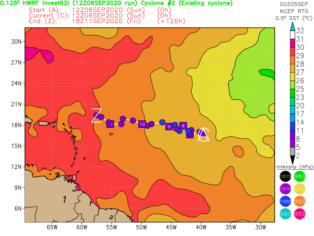
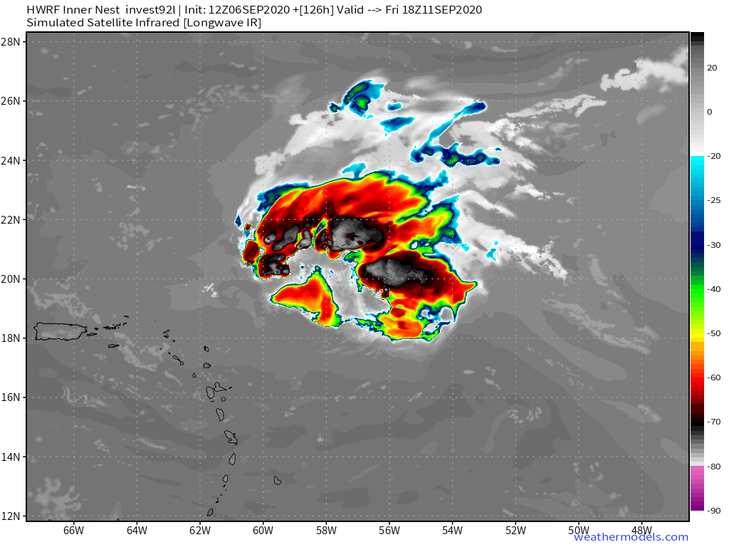
HWRF running, keeps 92L weak due to strong wind shear through 60 hours.
0 likes
My posts are my own personal opinion, defer to the National Hurricane Center (NHC) and other NOAA products for decision making during hurricane season.
-
SFLcane

- S2K Supporter
- Posts: 9606
- Age: 46
- Joined: Sat Jun 05, 2010 1:44 pm
- Location: Lake Worth Florida
Re: ATL: INVEST 92L - Models
Hypercane_Kyle wrote:HWRF running, keeps 92L weak due to strong wind shear through 60 hours.
Keeps it weak but far west.
Last edited by SFLcane on Sun Sep 06, 2020 1:54 pm, edited 1 time in total.
1 likes
Re: ATL: INVEST 92L - Models
SFLcane wrote:Hypercane_Kyle wrote:HWRF running, keeps 92L weak due to strong wind shear through 60 hours.
Keeps it weak but far west.
Yes, the HWRF differs significantly from the globals, trackwise
0 likes
-
gatorcane

- S2K Supporter
- Posts: 23499
- Age: 46
- Joined: Sun Mar 13, 2005 3:54 pm
- Location: Boca Raton, FL
Re: ATL: INVEST 92L - Models
12Z Euro recurves across Central Atlantic. Posted in global models thread since we can see what it does with the rest of the systems.
1 likes
-
SFLcane
- S2K Supporter
- Posts: 9606
- Age: 46
- Joined: Sat Jun 05, 2010 1:44 pm
- Location: Lake Worth Florida
ATL: SEVENTEEN - Tropical Depression - Discussion
sma10 wrote:Aric Dunn wrote:DestinHurricane wrote:
Certainly a possibility it gets into the Gulf if a magic trapdoor doesn't open somewhere. After all, it's still september 6, it's not october just yet. This is still the heart of Cape Verde season.
mentioned earlier that a western atlantic turn is most likely. the solutions turning north before reaching the longitude of the islands is very unlikely since the initial turn is from the interaction of 92L and 93L. which is the real issue with the models.
Note the HWRF. Around 19.5n 58w at end of run. No interaction with 93L
Could still recurve near 60w but this is how the hwrf ends.
0 likes

Re: ATL: INVEST 92L - Models
18z GFS takes it further west and weaker like HWRF. Wait and see on this one.
1 likes
-
AtlanticWind

- S2K Supporter
- Posts: 1805
- Age: 65
- Joined: Sun Aug 08, 2004 9:57 pm
- Location: Plantation,Fla
Re: ATL: INVEST 92L - Models
None of the 18z intensity models on tropical tidbits make this a hurricane.
Not buying that at the moment
Not buying that at the moment
1 likes
Re: ATL: INVEST 92L - Models
AtlanticWind wrote:None of the 18z intensity models on tropical tidbits make this a hurricane.
Not buying that at the moment
The HWRF, routinely mocked for aggression, keeps this a weak TS and moves it very close to the islands
0 likes
Re: ATL: SEVENTEEN - Tropical Depression - Discussion
18Z EPS 144: TD17 is on lower right. Similar to the 6Z EPS, a good number of these aren't clearcut OTS recurves:

4 likes
Personal Forecast Disclaimer:
The posts in this forum are NOT official forecasts and should not be used as such. They are just the opinion of the poster and may or may not be backed by sound meteorological data. They are NOT endorsed by any professional institution or storm2k.org. For official information, please refer to the NHC and NWS products.
The posts in this forum are NOT official forecasts and should not be used as such. They are just the opinion of the poster and may or may not be backed by sound meteorological data. They are NOT endorsed by any professional institution or storm2k.org. For official information, please refer to the NHC and NWS products.
Re: ATL: SEVENTEEN - Tropical Depression - Discussion
LarryWx wrote:18Z EPS 144: TD17 is on lower right. Similar to the 6Z EPS, a good number of these aren't clearcut OTS recurves:
https://i.imgur.com/D92Oz1D.png
Larry, also not sure how much stock you put in the hurricane models, but 18z HMON and HWRF are also unclear OTS scenarios
1 likes
-
CrazyC83
- Professional-Met

- Posts: 33393
- Joined: Tue Mar 07, 2006 11:57 pm
- Location: Deep South, for the first time!
Re: ATL: SEVENTEEN - Models
Weaker would keep it farther west I would think? While a strong Paulette would interact with what would be Rene and create chaos in the central Atlantic?
3 likes
-
AutoPenalti
- Category 5
- Posts: 3949
- Age: 27
- Joined: Mon Aug 17, 2015 4:16 pm
- Location: Ft. Lauderdale, Florida
Re: ATL: SEVENTEEN - Models
I’m starting to suspect a lot of these supposed OTS scenarios seem to be influenced by fujiwhara interactions.
2 likes
The posts in this forum are NOT official forecasts and should not be used as such. They are just the opinion of the poster and may or may not be backed by sound meteorological data. They are NOT endorsed by any professional institution or STORM2K. For official information, please refer to products from the NHC and NWS.
Model Runs Cheat Sheet:
GFS (5:30 AM/PM, 11:30 AM/PM)
HWRF, GFDL, UKMET, NAVGEM (6:30-8:00 AM/PM, 12:30-2:00 AM/PM)
ECMWF (1:45 AM/PM)
TCVN is a weighted averaged
-
Aric Dunn
- Category 5
- Posts: 21228
- Age: 41
- Joined: Sun Sep 19, 2004 9:58 pm
- Location: Ready for the Chase.
- Contact:
Re: ATL: SEVENTEEN - Models
oh boy looks like the GFS is trapped.. hige swing again from GFS>
0 likes
Note: If I make a post that is brief. Please refer back to previous posts for the analysis or reasoning. I do not re-write/qoute what my initial post said each time.
If there is nothing before... then just ask
Space & Atmospheric Physicist, Embry-Riddle Aeronautical University,
I believe the sky is falling...
If there is nothing before... then just ask
Space & Atmospheric Physicist, Embry-Riddle Aeronautical University,
I believe the sky is falling...
-
USTropics
- Category 5
- Posts: 2408
- Joined: Sun Aug 12, 2007 3:45 am
- Location: Florida State University
Re: ATL: SEVENTEEN - Models
CrazyC83 wrote:Weaker would keep it farther west I would think? While a strong Paulette would interact with what would be Rene and create chaos in the central Atlantic?
That's exactly what the 00z GFS operational model has this run. A weaker TD17 (far WATL) escapes any interaction with 93L (now a hurricane in EATL), and gets pretty far west this run. We also have 93L pumping up a thin ridge that's steering the wave (CATL) exiting Africa later this week:

2 likes
-
Aric Dunn
- Category 5
- Posts: 21228
- Age: 41
- Joined: Sun Sep 19, 2004 9:58 pm
- Location: Ready for the Chase.
- Contact:
Re: ATL: SEVENTEEN - Models
USTropics wrote:CrazyC83 wrote:Weaker would keep it farther west I would think? While a strong Paulette would interact with what would be Rene and create chaos in the central Atlantic?
That's exactly what the 00z GFS operational model has this run. A weaker TD17 (far WATL) escapes any interaction with 93L (now a hurricane in EATL), and gets pretty far west this run. We also have 93L pumping up a thin ridge that's steering the wave (CATL) exiting Africa later this week:
https://i.imgur.com/uDjDb7x.png
We can at least say one thing..
the models are a giant mess right now.. couple more days and things should begin to resolve themselves.
2 likes
Note: If I make a post that is brief. Please refer back to previous posts for the analysis or reasoning. I do not re-write/qoute what my initial post said each time.
If there is nothing before... then just ask
Space & Atmospheric Physicist, Embry-Riddle Aeronautical University,
I believe the sky is falling...
If there is nothing before... then just ask
Space & Atmospheric Physicist, Embry-Riddle Aeronautical University,
I believe the sky is falling...
-
Shell Mound
- Category 5
- Posts: 2434
- Age: 31
- Joined: Thu Sep 07, 2017 3:39 pm
- Location: St. Petersburg, FL → Scandinavia
Re: ATL: SEVENTEEN - Tropical Depression - Discussion
LarryWx wrote:18Z EPS 144: TD17 is on lower right. Similar to the 6Z EPS, a good number of these aren't clearcut OTS recurves:
https://i.imgur.com/D92Oz1D.png
Note, however, that even the ambiguous members are well north of the islands. Normally, a TC in that position would miss the mainland U.S. and threaten Bermuda. So even if TD Seventeen “bends back” in the long range, it would be sufficiently far to the north that an incoming trough would take it OTS. At most TD Seventeen would pose a potential threat to Bermuda, but that’s about it. As far as potential impacts to the mainland U.S. are concerned, I would be much more anxious if the models were showing TD Seventeen tracking closer to or through Hebert Box #1 (15°–20°N, 60°–65°W). I don’t think these latest model runs will make much of a difference in the ultimate outcome, which is still heavily weighted toward OTS solutions or threats to Bermuda at most.
1 likes
CVW / MiamiensisWx / Shell Mound
The posts in this forum are NOT official forecasts and should not be used as such. They are just the opinion of the poster and may or may not be backed by sound meteorological data. They are NOT endorsed by any professional institution or STORM2K. For official information, please refer to products from the NHC and NWS.
Who is online
Users browsing this forum: No registered users and 42 guests