ATL: TEDDY - Post-Tropical - Discussion
Moderator: S2k Moderators
-
SconnieCane
- Category 4

- Posts: 913
- Joined: Thu Aug 02, 2018 5:29 pm
- Location: Madison, WI
Re: ATL: TEDDY - Post-Tropical - Discussion
Looks like a landfall in the south-central coast of Nova Scotia is rapidly closing in. With that size and speed, there should be quite a storm surge to the right of center.
0 likes
-
Sciencerocks
- Category 5

- Posts: 7282
- Age: 38
- Joined: Thu Jul 06, 2017 1:51 am
Re: ATL: TEDDY - Post-Tropical - Discussion
It is my opinion that in post season that this system will be shown to have been subtropical up until landfall.
0 likes

Re: ATL: TEDDY - Post-Tropical - Discussion
Why are they always going to Post-Tropical for all these systems instead of Sub-Tropical??? Did they get away from using that term? A lot of these systems that they rule as Post Tropical now, in the past would of been Sub Tropical.
1 likes
Personal Forecast Disclaimer:
The posts in this forum are NOT official forecast and should not be used as such. They are just the opinion of the poster and may or may not be backed by sound meteorological data. They are NOT endorsed by any professional institution or storm2k.org. For official information, please refer to the NHC and NWS products.
The posts in this forum are NOT official forecast and should not be used as such. They are just the opinion of the poster and may or may not be backed by sound meteorological data. They are NOT endorsed by any professional institution or storm2k.org. For official information, please refer to the NHC and NWS products.
-
PavelGaborik10
- Category 1

- Posts: 403
- Joined: Tue Sep 04, 2018 3:23 pm
Re: ATL: TEDDY - Post-Tropical - Discussion
A complete dud here in Eastern Cape Breton. A couple of areas with gusts in the 50-60 MPH range but most regions barely touched 35-40.
0 likes
-
Kazmit

- Category 5
- Posts: 1915
- Age: 21
- Joined: Mon Jul 25, 2016 8:49 am
- Location: Williamsburg VA for college, Bermuda otherwise
Re: ATL: TEDDY - Post-Tropical - Discussion
Blinhart wrote:Why are they always going to Post-Tropical for all these systems instead of Sub-Tropical??? Did they get away from using that term? A lot of these systems that they rule as Post Tropical now, in the past would of been Sub Tropical.
Good question, I've never really seen the NHC take a system from fully tropical to sub-tropical.
0 likes
Igor 2010, Sandy 2012, Fay 2014, Gonzalo 2014, Joaquin 2015, Nicole 2016, Humberto 2019
I am only a tropical weather enthusiast. My predictions are not official and may or may not be backed by sound meteorological data. For official information, please refer to the NHC and NWS products.
I am only a tropical weather enthusiast. My predictions are not official and may or may not be backed by sound meteorological data. For official information, please refer to the NHC and NWS products.
-
NotoSans
- Category 5
- Posts: 1366
- Age: 24
- Joined: Sun Sep 27, 2015 1:15 am
- Location: Hong Kong
- Contact:
Re: ATL: TEDDY - Post-Tropical - Discussion
Blinhart wrote:Why are they always going to Post-Tropical for all these systems instead of Sub-Tropical??? Did they get away from using that term? A lot of these systems that they rule as Post Tropical now, in the past would of been Sub Tropical.
Extracted from NHC's glossary:
A non-frontal low-pressure system that has characteristics of both tropical and extratropical cyclones. Like tropical cyclones, they are non-frontal, synoptic-scale cyclones that originate over tropical or subtropical waters, and have a closed surface wind circulation about a well-defined center. In addition, they have organized moderate to deep convection, but lack a central dense overcast. Unlike tropical cyclones, subtropical cyclones derive a significant proportion of their energy from baroclinic sources, and are generally cold-core in the upper troposphere, often being associated with an upper-level low or trough. In comparison to tropical cyclones, these systems generally have a radius of maximum winds occurring relatively far from the center (usually greater than 60 n mi), and generally have a less symmetric wind field and distribution of convection.
The key is: even though subtropical cyclones are often considered "hybrid" systems, they are non-frontal. Since Teddy is now well-connected to a front, the best (if not the only possible) classification is extratropical, NOT subtropical. Extratropical is one common category of post-tropical cyclones (the other being remnant lows).
It is not rare for extratropical cyclones to exhibit some deep convection or even a weak warm core, but as long as they are frontal they should be classified as extratropical, NOT subtropical.
5 likes
Personal Forecast Disclaimer:
The posts in this forum are NOT official forecast and should not be used as such. They are just the opinion of the poster and may or may not be backed by sound meteorological data. They are NOT endorsed by any professional institution or storm2k.org. For official information, please refer to RSMC and NWS products.
The posts in this forum are NOT official forecast and should not be used as such. They are just the opinion of the poster and may or may not be backed by sound meteorological data. They are NOT endorsed by any professional institution or storm2k.org. For official information, please refer to RSMC and NWS products.

Re: ATL: TEDDY - Post-Tropical - Discussion
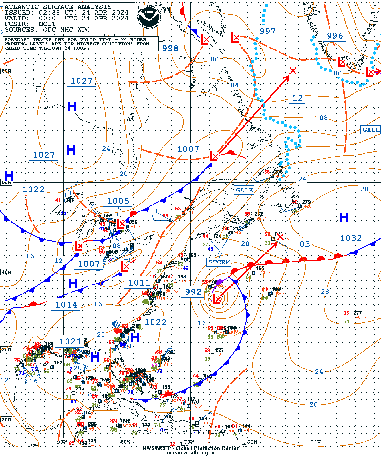
Here's a surface map of Post-Teddy and surrounds:
https://ocean.weather.gov/A_w_sfc_color.png
It can be clearly seen connected to three fronts, which are arranged like a mature extratropical cyclone.
https://ocean.weather.gov/A_w_sfc_color.png
It can be clearly seen connected to three fronts, which are arranged like a mature extratropical cyclone.
2 likes
-
SconnieCane
- Category 4
- Posts: 913
- Joined: Thu Aug 02, 2018 5:29 pm
- Location: Madison, WI
Re: ATL: TEDDY - Post-Tropical - Discussion
JRD wrote:Here's a surface map of Post-Teddy and surrounds:
https://ocean.weather.gov/A_w_sfc_color.png
It can be clearly seen connected to three fronts, which are arranged like a mature extratropical cyclone.
By that map, the front connects all the way to the remnants of Beta over Texas!

2 likes
-
Hybridstorm_November2001

- S2K Supporter

- Posts: 2802
- Joined: Sat Aug 21, 2004 2:50 pm
- Location: SW New Brunswick, Canada
- Contact:
Re: ATL: TEDDY - Post-Tropical - Discussion
Teddy was very mild here near Calais Maine/St. Stephen New Brunswick area. My weather station record a couple peak gusts of 56 kmh/35 mph and 15 mm/0.60 Inches of rain in 24 hours. The NHC had us shaded in TS force winds but at least at my property I never registered 39 mph. 
2 likes
-
cheezyWXguy

- Category 5
- Posts: 5528
- Joined: Mon Feb 13, 2006 12:29 am
- Location: Dallas, TX
Re: ATL: TEDDY - Post-Tropical - Discussion
Hybridstorm_November2001 wrote:Teddy was very mild here near Calais Maine/St. Stephen New Brunswick area. My weather station record a couple peak gusts of 56 kmh/35 mph and 15 mm/0.60 Inches of rain in 24 hours. The NHC had us shaded in TS force winds but at least at my property I never registered 39 mph.
Glad to hear it. This year has already had too many significant landfalls, and with October rolling around I am concerned there will be more. I am sure you guys in Canada will be happy to be excluded from the “fun”.
2 likes
-
PavelGaborik10
- Category 1
- Posts: 403
- Joined: Tue Sep 04, 2018 3:23 pm
Re: ATL: TEDDY - Post-Tropical - Discussion
Hybridstorm_November2001 wrote:Teddy was very mild here near Calais Maine/St. Stephen New Brunswick area. My weather station record a couple peak gusts of 56 kmh/35 mph and 15 mm/0.60 Inches of rain in 24 hours. The NHC had us shaded in TS force winds but at least at my property I never registered 39 mph.
The NHC had four different provinces with a 100% chance of 39 MPH sustained winds because it was extratropical.
Those graphs go off the grid with post-tropical systems, it was never even remotely feasible.
0 likes
-
Hybridstorm_November2001
- S2K Supporter
- Posts: 2802
- Joined: Sat Aug 21, 2004 2:50 pm
- Location: SW New Brunswick, Canada
- Contact:
Re: ATL: TEDDY - Post-Tropical - Discussion
I've posted the event summary for each Maritime province at my blog -
http://hybridstorm-weatherblog.blogspot.com/
For those unfamiliar with meteric 120 km per hour roughly translates to 75 mph and 25 mm of rainfall roughly translates to 1 inch of rainfall. Only a couple of areas in Nova recorded hurricane force winds and none were sustained.
http://hybridstorm-weatherblog.blogspot.com/
For those unfamiliar with meteric 120 km per hour roughly translates to 75 mph and 25 mm of rainfall roughly translates to 1 inch of rainfall. Only a couple of areas in Nova recorded hurricane force winds and none were sustained.
0 likes
-
Hybridstorm_November2001
- S2K Supporter
- Posts: 2802
- Joined: Sat Aug 21, 2004 2:50 pm
- Location: SW New Brunswick, Canada
- Contact:
Re: ATL: TEDDY - Post-Tropical - Discussion
PavelGaborik10 wrote:Hybridstorm_November2001 wrote:Teddy was very mild here near Calais Maine/St. Stephen New Brunswick area. My weather station record a couple peak gusts of 56 kmh/35 mph and 15 mm/0.60 Inches of rain in 24 hours. The NHC had us shaded in TS force winds but at least at my property I never registered 39 mph.
The NHC had four different provinces with a 100% chance of 39 MPH sustained winds because it was extratropical.
Those graphs go off the grid with post-tropical systems, it was never even remotely feasible.
Uh, no, I was referring to the wind field analysis maps from the NHC not the wind proablilty maps. My area was shaded in orange on two occasions for 40 mph winds (gusts at minimum) and we never received such winds (to my knowledge). The NHC wind field analysis maps are typically accurate, in my experience (Irene, Aruthur, Dorian, exact), so I was a tad surprised Teddy proved weaker than they thought.
0 likes
-
CrazyC83
- Professional-Met

- Posts: 33393
- Joined: Tue Mar 07, 2006 11:57 pm
- Location: Deep South, for the first time!
Re: ATL: TEDDY - Post-Tropical - Discussion
The posts in this forum are NOT official forecasts and should not be used as such. They are just the opinion of the poster and may or may not be backed by sound meteorological data. They are NOT endorsed by any professional institution or STORM2K. For official information, please refer to products from the NHC and NWS.
AL202020, TEDDY, 53,
20200912, 0000, , LO, 11.4N, 29.8W, 25, 1007,
20200912, 0600, , LO, 11.3N, 31.2W, 30, 1006,
20200912, 1200, , TD, 11.3N, 32.4W, 30, 1006,
20200912, 1800, , TD, 11.4N, 33.3W, 30, 1005,
20200913, 0000, , TD, 11.6N, 34.2W, 30, 1005,
20200913, 0600, , TD, 11.9N, 35.1W, 30, 1005,
20200913, 1200, , TD, 12.2N, 36.2W, 30, 1005,
20200913, 1800, , TS, 12.5N, 37.4W, 35, 1004,
20200914, 0000, , TS, 12.8N, 38.8W, 35, 1003,
20200914, 0600, , TS, 12.9N, 40.4W, 35, 1003,
20200914, 1200, , TS, 12.8N, 42.2W, 40, 1002,
20200914, 1800, , TS, 12.9N, 43.4W, 45, 1000,
20200915, 0000, , TS, 13.1N, 44.5W, 50, 998,
20200915, 0600, , TS, 13.4N, 45.5W, 50, 997,
20200915, 1200, , TS, 13.8N, 46.5W, 55, 995,
20200915, 1800, , TS, 14.2N, 47.4W, 60, 992,
20200916, 0000, , HU, 14.7N, 48.0W, 70, 984,
20200916, 0600, , HU, 15.4N, 48.6W, 85, 974,
20200916, 1200, , HU, 16.1N, 49.3W, 80, 978,
20200916, 1800, , HU, 16.8N, 50.2W, 75, 981,
20200917, 0000, , HU, 17.4N, 51.1W, 75, 980,
20200917, 0600, , HU, 18.0N, 52.0W, 90, 968,
20200917, 1200, , HU, 18.9N, 52.8W, 105, 954,
20200917, 1800, , HU, 19.7N, 53.7W, 120, 946,
20200918, 0000, , HU, 20.5N, 54.2W, 115, 947,
20200918, 0600, , HU, 21.2N, 55.1W, 110, 949,
20200918, 1200, , HU, 21.7N, 55.8W, 110, 950,
20200918, 1800, , HU, 22.6N, 56.5W, 105, 951,
20200919, 0000, , HU, 23.5N, 57.1W, 105, 950,
20200919, 0600, , HU, 24.4N, 57.8W, 105, 950,
20200919, 1200, , HU, 25.5N, 58.6W, 100, 953,
20200919, 1800, , HU, 26.3N, 59.8W, 95, 955,
20200920, 0000, , HU, 26.9N, 60.8W, 90, 957,
20200920, 0600, , HU, 27.5N, 61.9W, 85, 960,
20200920, 1200, , HU, 28.0N, 62.6W, 80, 963,
20200920, 1800, , HU, 28.5N, 63.3W, 80, 963,
20200921, 0000, , HU, 29.0N, 63.7W, 80, 962,
20200921, 0600, , HU, 29.7N, 63.5W, 80, 961,
20200921, 1200, , HU, 30.5N, 62.8W, 75, 959,
20200921, 1800, , HU, 32.2N, 61.8W, 75, 957,
20200922, 0000, , HU, 34.6N, 61.4W, 80, 954,
20200922, 0600, , HU, 37.6N, 62.2W, 85, 951,
20200922, 1200, , HU, 39.1N, 63.5W, 85, 948,
20200922, 1800, , HU, 40.3N, 64.2W, 80, 950,
20200923, 0000, , EX, 41.8N, 64.2W, 70, 952,
20200923, 0600, , EX, 43.2N, 63.3W, 60, 958,
20200923, 1200, L, EX, 44.9N, 62.1W, 55, 963,
20200923, 1800, , EX, 47.4N, 60.4W, 50, 970,
20200924, 0000, , EX, 31.5N, 86.5W, 45, 974,
*The biggest changes are to up the intensities slightly (and sooner) in the first half of the life, and drop them some in the second half. For the most part, the operational thoughts for the intensity largely stand.
* Genesis is moved up 12 hours as well, while extratropical transition is also moved up 6 hours.
4 likes

Re: ATL: TEDDY - Post-Tropical - Discussion
PavelGaborik10 wrote:A complete dud here in Eastern Cape Breton. A couple of areas with gusts in the 50-60 MPH range but most regions barely touched 35-40.
Its not really a surprise. The models consistently showed Teddy weakening one it started to make that turn back to the northeast. From the reports, it seems that exactly what panned out.
0 likes
Re: ATL: TEDDY - Post-Tropical - Discussion
Blinhart wrote:Why are they always going to Post-Tropical for all these systems instead of Sub-Tropical??? Did they get away from using that term? A lot of these systems that they rule as Post Tropical now, in the past would of been Sub Tropical.
Storms typically are not called subtropical while in transition- which sort of makes sense. Storms ordinarily develop some degree of hybrid characteristics when becoming extratropical. It would be a confusing designator to the lay public who may interpret this as the storm weakening--to below (sub) tropical storm status; when in fact the storm may have actually briefly strengthened some at the start of the extratropical transition. Traditional subtropical storms almost never reach hurricane strength- while "extratropical transition" subtropicals would frequently have strengths of over 85mph. Systems also are developing , rather than losing frontal characteristics when becoming extratropical.
1 likes
All posts by Dean_175 are NOT official forecasts and should not be used as such. They are just the opinion of the poster and may or may not be backed by sound meteorological data. They are NOT endorsed by any professional institution or storm2k.org. For official information, please refer to the NHC and NWS products.
-
PavelGaborik10
- Category 1
- Posts: 403
- Joined: Tue Sep 04, 2018 3:23 pm
Re: ATL: TEDDY - Post-Tropical - Discussion
tomatkins wrote:PavelGaborik10 wrote:A complete dud here in Eastern Cape Breton. A couple of areas with gusts in the 50-60 MPH range but most regions barely touched 35-40.
Its not really a surprise. The models consistently showed Teddy weakening one it started to make that turn back to the northeast. From the reports, it seems that exactly what panned out.
It underperformed even the most conservative forecasts. It wouldn't even crack the top 20 for storms this year here.
Just a normal slightly windy day with a bit of rain mixed in.
0 likes
-
AnnularCane

- S2K Supporter
- Posts: 2629
- Joined: Thu Jun 08, 2006 9:18 am
- Location: Wytheville, VA
Who is online
Users browsing this forum: No registered users and 15 guests