ATL: DELTA - Models
Moderator: S2k Moderators
-
cycloneye

- Admin

- Posts: 139334
- Age: 67
- Joined: Thu Oct 10, 2002 10:54 am
- Location: San Juan, Puerto Rico
ATL: DELTA - Models
Only model runs.
1 likes
Visit the Caribbean-Central America Weather Thread where you can find at first post web cams,radars
and observations from Caribbean basin members Click Here
and observations from Caribbean basin members Click Here
-
Spacecoast

- Category 2

- Posts: 687
- Joined: Thu Aug 31, 2017 2:03 pm


-
CyclonicFury

- Category 5

- Posts: 1975
- Age: 25
- Joined: Sun Jul 02, 2017 12:32 pm
- Location: NC
- Contact:
Re: ATL: INVEST 92L - Models
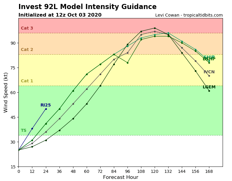
Very favorable environment for the next 5 days. Not sure why the global models are bearish on significant development but they have been downright awful with Caribbean genesis this year. Just a couple days ago the Euro didn't even show a TD and Gamma might become a hurricane before landfall. 92L definitely bears watching based on this environment and climatology.
* GFS version *
* ATLANTIC 2020 SHIPS INTENSITY FORECAST *
* IR SAT DATA AVAILABLE, OHC AVAILABLE *
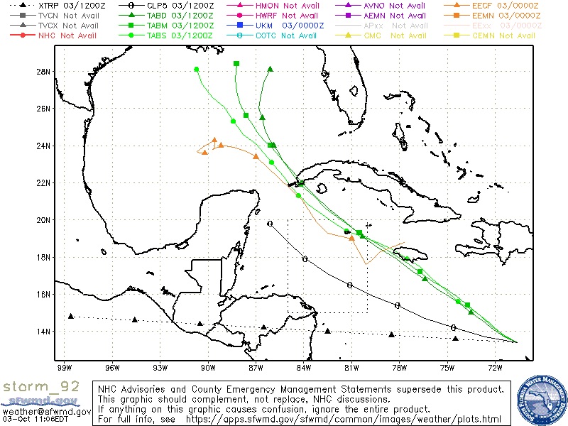
* INVEST AL922020 10/03/20 12 UTC *
TIME (HR) 0 6 12 18 24 36 48 60 72 84 96 108 120 132 144 156 168
V (KT) NO LAND 25 28 31 35 41 50 61 71 77 83 88 93 95 96 91 86 79
V (KT) LAND 25 28 31 35 41 50 61 71 77 83 78 92 94 94 90 85 78
V (KT) LGEM 25 26 27 29 31 37 44 53 64 77 89 97 99 95 84 73 61
Storm Type TROP TROP TROP TROP TROP TROP TROP TROP TROP TROP TROP TROP TROP TROP TROP TROP TROP
SHEAR (KT) 12 10 7 7 5 5 4 5 3 3 2 4 8 13 18 28 32
SHEAR ADJ (KT) 0 0 -2 -3 0 0 -5 -2 0 0 -2 -1 -6 0 -4 -1 1
SHEAR DIR 327 336 325 332 23 46 270 127 168 144 94 162 247 253 256 253 255
SST (C) 29.6 29.7 29.8 29.8 29.7 29.8 30.1 30.2 30.3 30.4 30.6 30.2 29.8 29.0 28.0 27.5 26.8
POT. INT. (KT) 162 164 165 165 164 165 171 172 172 172 171 170 164 149 135 129 121
ADJ. POT. INT. 159 161 162 162 159 158 164 167 170 170 168 153 143 130 118 112 105
200 MB T (C) -53.8 -53.5 -53.2 -53.1 -53.1 -52.9 -53.0 -52.8 -52.9 -52.5 -52.8 -52.4 -52.9 -52.6 -53.0 -53.2 -53.7
200 MB VXT (C) 0.1 0.1 -0.1 -0.2 -0.3 0.1 -0.2 0.1 0.2 0.3 0.3 0.3 0.5 0.4 0.2 0.1 0.1
TH_E DEV (C) 7 10 8 8 7 8 7 8 7 8 7 7 5 6 3 5 2
700-500 MB RH 72 71 72 73 72 70 71 71 71 71 69 68 69 69 69 73 77
MODEL VTX (KT) 5 5 4 5 7 7 7 7 7 8 8 9 9 9 8 8 6
850 MB ENV VOR 35 45 50 54 52 64 55 56 36 42 27 21 30 54 47 20 -25
200 MB DIV 15 6 13 30 48 57 49 38 33 49 40 40 25 27 9 32 33
700-850 TADV 1 2 1 5 3 -2 0 -5 1 0 2 3 0 2 2 9 7
LAND (KM) 144 148 207 287 289 204 70 11 262 186 -5 136 256 355 412 256 117
LAT (DEG N) 13.4 13.8 14.3 14.8 15.4 16.3 17.2 18.2 19.3 20.6 21.9 23.2 24.0 xx.x xx.x xx.x xx.x
LONG(DEG W) 70.6 71.4 72.2 72.9 73.7 75.1 76.7 78.4 80.5 82.6 84.2 85.3 86.1 xxx.x xxx.x xxx.x xxx.x
STM SPEED (KT) 9 9 9 9 9 8 9 10 12 11 9 6 5 5 7 7 8
HEAT CONTENT 54 69 82 95 98 106 108 129 132 106 116 93 46 32 23 19 11
* ATLANTIC 2020 SHIPS INTENSITY FORECAST *
* IR SAT DATA AVAILABLE, OHC AVAILABLE *
* INVEST AL922020 10/03/20 12 UTC *
TIME (HR) 0 6 12 18 24 36 48 60 72 84 96 108 120 132 144 156 168
V (KT) NO LAND 25 28 31 35 41 50 61 71 77 83 88 93 95 96 91 86 79
V (KT) LAND 25 28 31 35 41 50 61 71 77 83 78 92 94 94 90 85 78
V (KT) LGEM 25 26 27 29 31 37 44 53 64 77 89 97 99 95 84 73 61
Storm Type TROP TROP TROP TROP TROP TROP TROP TROP TROP TROP TROP TROP TROP TROP TROP TROP TROP
SHEAR (KT) 12 10 7 7 5 5 4 5 3 3 2 4 8 13 18 28 32
SHEAR ADJ (KT) 0 0 -2 -3 0 0 -5 -2 0 0 -2 -1 -6 0 -4 -1 1
SHEAR DIR 327 336 325 332 23 46 270 127 168 144 94 162 247 253 256 253 255
SST (C) 29.6 29.7 29.8 29.8 29.7 29.8 30.1 30.2 30.3 30.4 30.6 30.2 29.8 29.0 28.0 27.5 26.8
POT. INT. (KT) 162 164 165 165 164 165 171 172 172 172 171 170 164 149 135 129 121
ADJ. POT. INT. 159 161 162 162 159 158 164 167 170 170 168 153 143 130 118 112 105
200 MB T (C) -53.8 -53.5 -53.2 -53.1 -53.1 -52.9 -53.0 -52.8 -52.9 -52.5 -52.8 -52.4 -52.9 -52.6 -53.0 -53.2 -53.7
200 MB VXT (C) 0.1 0.1 -0.1 -0.2 -0.3 0.1 -0.2 0.1 0.2 0.3 0.3 0.3 0.5 0.4 0.2 0.1 0.1
TH_E DEV (C) 7 10 8 8 7 8 7 8 7 8 7 7 5 6 3 5 2
700-500 MB RH 72 71 72 73 72 70 71 71 71 71 69 68 69 69 69 73 77
MODEL VTX (KT) 5 5 4 5 7 7 7 7 7 8 8 9 9 9 8 8 6
850 MB ENV VOR 35 45 50 54 52 64 55 56 36 42 27 21 30 54 47 20 -25
200 MB DIV 15 6 13 30 48 57 49 38 33 49 40 40 25 27 9 32 33
700-850 TADV 1 2 1 5 3 -2 0 -5 1 0 2 3 0 2 2 9 7
LAND (KM) 144 148 207 287 289 204 70 11 262 186 -5 136 256 355 412 256 117
LAT (DEG N) 13.4 13.8 14.3 14.8 15.4 16.3 17.2 18.2 19.3 20.6 21.9 23.2 24.0 xx.x xx.x xx.x xx.x
LONG(DEG W) 70.6 71.4 72.2 72.9 73.7 75.1 76.7 78.4 80.5 82.6 84.2 85.3 86.1 xxx.x xxx.x xxx.x xxx.x
STM SPEED (KT) 9 9 9 9 9 8 9 10 12 11 9 6 5 5 7 7 8
HEAT CONTENT 54 69 82 95 98 106 108 129 132 106 116 93 46 32 23 19 11
3 likes
NCSU B.S. in Meteorology Class of 2021. Tropical weather blogger at http://www.cyclonicfury.com. My forecasts and thoughts are NOT official, for official forecasts please consult the National Hurricane Center.


Re: ATL: INVEST 92L - Models
12z ICON looks confused with a fujiwara setup in the Gulf. This would actually be the third in a series of multiple vortexes in the Gulf of Mexico which we saw during Sally and with Laura/Marco. We don't see that in any typical years, though there was a season a few back that had really strong storms in the Western Atlantic coming up north with a few baby brother systems to their east.
ICON focuses most of the Gulf energy with 92L by 114 hours, so it's fairly far north in the Gulf and absorbing Gamma.

ICON focuses most of the Gulf energy with 92L by 114 hours, so it's fairly far north in the Gulf and absorbing Gamma.
0 likes
Re: ATL: INVEST 92L - Models
GFS Para has Delta setting up a camp right off Tampa Bay sitting and spinning for a few days before finally moving back west and then back east again.
2 likes
-
AnnularCane

- S2K Supporter

- Posts: 2647
- Joined: Thu Jun 08, 2006 9:18 am
- Location: Wytheville, VA
Re: ATL: INVEST 92L - Models
cp79 wrote:GFS Para has Delta setting up a camp right off Tampa Bay sitting and spinning for a few days before finally moving back west and then back east again.
Elena 2.0?
0 likes


Re: ATL: INVEST 92L - Models
I think the GFS and GFS-Para are too far north for 92L just like they were for Gamma. I don’t see how the wave will rapidly move so far north when it and all of its associated vorticity has remained south for the last few days.
2 likes
Irene '11 Sandy '12 Hermine '16 5/15/2018 Derecho Fay '20 Isaias '20 Elsa '21 Henri '21 Ida '21
I am only a meteorology enthusiast who knows a decent amount about tropical cyclones. Look to the professional mets, the NHC, or your local weather office for the best information.
I am only a meteorology enthusiast who knows a decent amount about tropical cyclones. Look to the professional mets, the NHC, or your local weather office for the best information.
Re: ATL: INVEST 92L - Models
ICON 180h ends up where it was around 114h. It loops in the Gulf twice and is sitting south of the LA Coast at 180h.

Through 114h, CMC also slingshots 92L North toward the Mouth of the River (so farther north than the ICON) but it keeps Gamma stronger in the first 4 1/2 days which is why a smaller, weaker 92l/Delta is farther north.

Through 114h, CMC also slingshots 92L North toward the Mouth of the River (so farther north than the ICON) but it keeps Gamma stronger in the first 4 1/2 days which is why a smaller, weaker 92l/Delta is farther north.
2 likes
-
cycloneye
- Admin
- Posts: 139334
- Age: 67
- Joined: Thu Oct 10, 2002 10:54 am
- Location: San Juan, Puerto Rico
Re: ATL: INVEST 92L - Models
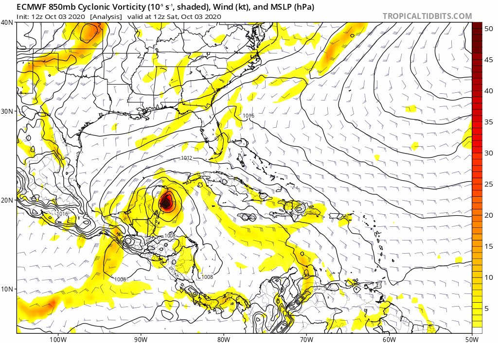
It depends about how Gamma is when it is in the GOM or BOC that this system will develop or not and the models are reflecting with no clarity.
1 likes
Visit the Caribbean-Central America Weather Thread where you can find at first post web cams,radars
and observations from Caribbean basin members Click Here
and observations from Caribbean basin members Click Here

Re: ATL: INVEST 92L - Models
I think the models are entirely out to lunch with 92L. First and foremost, Gamma is the captain steering the ship here lol. As long as Gamma remains a fairly large and cohesive T.S. even while moving NNW over N. Yucatan, it's hard for me to see ideal surface convergence for a developing tropical cyclone in the west central Caribbean. A significant and rapidly weakening Gamma over Yucatan could result in a fairly quick spin up of 92L, and a solution such as the ICON would seem closest to a depiction that has a developing 92L perhaps starting to coalesce in perhaps 48 hours, to first move north around Gamma's weakening circulation and then more slowly northwestward thereafter. I just don't think that upper level conditions seems ideal for 92L to organize all to quick. GFS Para appears nuts with it's solution of quick development and an immediate motion that takes 92L into S. Florida. The sharp TUTT that extends well south of Hispaniola and just to the west of 92L just seems enough of an inhibiting factor for an immediate development to occur. The southern extension of this TUTT is supposed to cut off and move westward. I just don't see how 92L develops all that quickly for at least 36-48 hours given what would seem like moderate upper level shear for the immediate future. Perhaps after 2-3 days's time the upper level conditions might be less hostile but it's hard for me to see how a more concentrated and developing disturbance will be as far north as some models are projecting (approx northwest of Jamaica).
3 likes
Personal Forecast Disclaimer:
The posts in this forum are NOT official forecast and should not be used as such. They are just the opinion of the poster and may or may not be backed by sound meteorological data. They are NOT endorsed by any professional institution or storm2k.org. For official information, please refer to the NHC and NWS products.
The posts in this forum are NOT official forecast and should not be used as such. They are just the opinion of the poster and may or may not be backed by sound meteorological data. They are NOT endorsed by any professional institution or storm2k.org. For official information, please refer to the NHC and NWS products.
Re: ATL: INVEST 92L - Models
aspen wrote:I think the GFS and GFS-Para are too far north for 92L just like they were for Gamma. I don’t see how the wave will rapidly move so far north when it and all of its associated vorticity has remained south for the last few days.
I agree. If upper level conditions were exceptional then a vertically stacked storm might well begin to gain latitude in the near term. I just don't see those conditions being that ideal for that to occur anytime fast.
2 likes
Personal Forecast Disclaimer:
The posts in this forum are NOT official forecast and should not be used as such. They are just the opinion of the poster and may or may not be backed by sound meteorological data. They are NOT endorsed by any professional institution or storm2k.org. For official information, please refer to the NHC and NWS products.
The posts in this forum are NOT official forecast and should not be used as such. They are just the opinion of the poster and may or may not be backed by sound meteorological data. They are NOT endorsed by any professional institution or storm2k.org. For official information, please refer to the NHC and NWS products.
Re: ATL: INVEST 92L - Models
chaser1 wrote:aspen wrote:I think the GFS and GFS-Para are too far north for 92L just like they were for Gamma. I don’t see how the wave will rapidly move so far north when it and all of its associated vorticity has remained south for the last few days.
I agree. If upper level conditions were exceptional then a vertically stacked storm might well begin to gain latitude in the near term. I just don't see those conditions being that ideal for that to occur anytime fast.
For sure. But we likely will also have somewhat of a gyre setting up with potential, multiple low level center interaction (per some models). I’m assuming in the Tuesday/Wednesday timeframe we should start to see the evolution and whether they end up with some type of energy merger or transfer with one strengthening over the other, then orbiting around a gyre or whatever. It’s a cool setup to watch that I don’t recall ever being exactly like this before.
Last edited by Steve on Sat Oct 03, 2020 1:04 pm, edited 1 time in total.
0 likes
-
SFLcane

- S2K Supporter
- Posts: 9617
- Age: 46
- Joined: Sat Jun 05, 2010 1:44 pm
- Location: Lake Worth Florida
Re: ATL: INVEST 92L - Models
chaser1 wrote:aspen wrote:I think the GFS and GFS-Para are too far north for 92L just like they were for Gamma. I don’t see how the wave will rapidly move so far north when it and all of its associated vorticity has remained south for the last few days.
I agree. If upper level conditions were exceptional then a vertically stacked storm might well begin to gain latitude in the near term. I just don't see those conditions being that ideal for that to occur anytime fast.
It’s getting better organized and conditions are expected to become quite favorable see nhc 2pm. 30-60% now
1 likes
Re: ATL: INVEST 92L - Models
So both Gamma and future Delta don't seem like they have enough steering to pull them far enough north into land. Euro seems like it wants to beeline it for NO and then puts on the brakes. Similar to GFS Para where it begins drifting it back east. I guess this is why October storms just don't hit the central Gulf Coast. The steering just isn't there to get them north enough. Front does look like it is beginning to come in at the end of Euro which should give this a nudge right.
0 likes
Re: ATL: INVEST 92L - Models
cp79 wrote:So both Gamma and future Delta don't seem like they have enough steering to pull them far enough north into land. Euro seems like it wants to beeline it for NO and then puts on the brakes. Similar to GFS Para where it begins drifting it back east. I guess this is why October storms just don't hit the central Gulf Coast. The steering just isn't there to get them north enough. Front does look like it is beginning to come in at the end of Euro which should give this a nudge right.
We do get some, but it’s more the exception. Just last year we had Olga in late October which is way way more the exception. But it does happen.
0 likes
Who is online
Users browsing this forum: No registered users and 6 guests