ATL: EPSILON - Models
Moderator: S2k Moderators
-
ElectricStorm

- Category 5

- Posts: 4553
- Age: 23
- Joined: Tue Aug 13, 2019 11:23 pm
- Location: Skiatook, OK / Norman, OK
Re: ATL: INVEST 94L - Models
18z GFS has 94L tracking just east of Bermuda as a hurricane
0 likes
I am in no way a professional. Take what I say with a grain of salt as I could be totally wrong. Please refer to the NHC, NWS, or SPC for official information.
Boomer Sooner!
Boomer Sooner!

Re: ATL: INVEST 94L - Models
HWRF gets this to a hurricane and passes VERY close to Bermuda.
1 likes
Irene '11 Sandy '12 Hermine '16 5/15/2018 Derecho Fay '20 Isaias '20 Elsa '21 Henri '21 Ida '21
I am only a meteorology enthusiast who knows a decent amount about tropical cyclones. Look to the professional mets, the NHC, or your local weather office for the best information.
I am only a meteorology enthusiast who knows a decent amount about tropical cyclones. Look to the professional mets, the NHC, or your local weather office for the best information.
-
ElectricStorm
- Category 5
- Posts: 4553
- Age: 23
- Joined: Tue Aug 13, 2019 11:23 pm
- Location: Skiatook, OK / Norman, OK
Re: ATL: INVEST 94L - Models
aspen wrote:HWRF gets this to a hurricane and passes VERY close to Bermuda.
With HWRF and GFS both showing similar solutions, Bermuda needs to pay very close attention to this
0 likes
I am in no way a professional. Take what I say with a grain of salt as I could be totally wrong. Please refer to the NHC, NWS, or SPC for official information.
Boomer Sooner!
Boomer Sooner!
-
ElectricStorm
- Category 5
- Posts: 4553
- Age: 23
- Joined: Tue Aug 13, 2019 11:23 pm
- Location: Skiatook, OK / Norman, OK
Re: ATL: INVEST 94L - Models
0z GFS has a hurricane by 54 hours, it has been pretty consistent on making 94L a hurricane. Center passes just east of Bermuda at 979mb. Gets down to 973mb just N of Bermuda. Ultimately bottoms out at 963mb before going extratropical. Pushing for a major on this run.
0 likes
I am in no way a professional. Take what I say with a grain of salt as I could be totally wrong. Please refer to the NHC, NWS, or SPC for official information.
Boomer Sooner!
Boomer Sooner!
-
cycloneye

- Admin

- Posts: 139083
- Age: 67
- Joined: Thu Oct 10, 2002 10:54 am
- Location: San Juan, Puerto Rico
Re: ATL: TWENTY-SEVEN - Models
* GFS version *
* ATLANTIC 2020 SHIPS INTENSITY FORECAST *
* IR SAT DATA AVAILABLE, OHC AVAILABLE *
* TWENTYSEV AL272020 10/19/20 12 UTC *
TIME (HR) 0 6 12 18 24 36 48 60 72 84 96 108 120 132 144 156 168
V (KT) NO LAND 35 38 43 47 52 61 72 78 82 85 92 93 94 92 91 83 67
V (KT) LAND 35 38 43 47 52 61 72 78 82 85 92 93 94 92 91 83 67
V (KT) LGEM 35 38 40 44 47 55 62 67 71 75 80 80 77 76 73 63 50
Storm Type TROP TROP TROP TROP TROP TROP TROP TROP TROP TROP TROP TROP TROP TROP TROP EXTP EXTP
SHEAR (KT) 21 18 19 19 13 16 3 2 11 11 9 20 9 16 20 28 46
SHEAR ADJ (KT) 0 0 -1 -1 0 -2 1 0 -2 -2 -1 0 -3 0 5 9 8
SHEAR DIR 262 242 235 248 253 198 196 271 284 216 200 165 116 207 192 220 238
SST (C) 27.6 27.6 27.6 27.6 27.7 27.5 27.0 26.7 26.3 26.3 26.3 26.0 25.9 26.7 24.4 24.1 19.4
POT. INT. (KT) 126 126 127 127 130 130 123 119 116 115 115 112 112 123 105 103 82
ADJ. POT. INT. 105 105 106 107 112 114 106 102 99 97 97 93 95 108 94 92 76
200 MB T (C) -56.5 -56.1 -55.8 -55.8 -55.8 -55.5 -55.5 -55.0 -55.4 -55.3 -55.2 -54.6 -54.4 -54.4 -54.9 -55.1 -55.9
200 MB VXT (C) 0.1 0.1 0.2 0.2 0.5 1.0 1.5 1.2 1.1 1.5 1.6 2.0 1.1 1.7 1.5 1.6 0.5
TH_E DEV (C) 8 8 7 7 6 7 6 7 7 7 6 6 6 5 2 0 0
700-500 MB RH 46 45 45 47 48 47 46 54 58 59 56 58 54 49 53 45 31
MODEL VTX (KT) 21 22 25 26 28 32 34 33 33 34 38 41 42 43 45 43 34
850 MB ENV VOR 132 138 149 144 144 152 158 152 134 116 106 121 117 122 88 128 80
200 MB DIV -6 5 17 27 30 50 49 17 28 46 83 102 59 47 116 64 20
700-850 TADV -3 -2 -3 1 7 17 11 2 2 5 10 5 3 8 7 32 -19
LAND (KM) 1351 1354 1357 1374 1392 1368 1325 1317 1392 1379 1260 1136 1006 881 771 592 628
LAT (DEG N) 25.7 25.8 25.8 26.0 26.2 27.4 28.3 28.8 30.1 31.2 32.0 32.9 34.1 xx.x xx.x xx.x xx.x
LONG(DEG W) 55.3 55.3 55.3 55.2 55.2 56.7 58.6 59.6 60.8 61.7 62.6 63.4 63.7 xxx.x xxx.x xxx.x xxx.x
STM SPEED (KT) 0 0 1 2 5 9 7 7 7 6 6 5 9 17 22 24 23
HEAT CONTENT 23 23 23 23 23 11 8 4 1 3 2 0 0 5 0 0 0
FORECAST TRACK FROM OFCI INITIAL HEADING/SPEED (DEG/KT): 0/ 0 CX,CY: 0/ 0
T-12 MAX WIND: 30 PRESSURE OF STEERING LEVEL (MB): 660 (MEAN=620)
GOES IR BRIGHTNESS TEMP. STD DEV. 50-200 KM RAD: 26.6 (MEAN=14.5)
% GOES IR PIXELS WITH T < -20 C 50-200 KM RAD: 54.0 (MEAN=65.0)
PRELIM RI PROB (DV .GE. 35 KT IN 36 HR): 10.5
INDIVIDUAL CONTRIBUTIONS TO INTENSITY CHANGE
6 12 18 24 36 48 60 72 84 96 108 120 132 144 156 168
------------------------------------------------------------------------------
SAMPLE MEAN CHANGE 1. 2. 3. 4. 6. 8. 9. 10. 11. 12. 12. 13. 14. 14. 15. 16.
SST POTENTIAL 0. 0. 1. 1. 3. 6. 9. 11. 13. 15. 15. 15. 14. 13. 12. 9.
VERTICAL SHEAR MAG 1. 2. 2. 3. 4. 5. 5. 5. 5. 4. 3. 2. 1. -1. -4. -8.
VERTICAL SHEAR ADJ 0. 0. 0. 1. 1. 1. 2. 2. 2. 2. 2. 2. 2. 1. 1. 0.
VERTICAL SHEAR DIR -0. -0. -0. -0. -0. 0. 0. 1. 1. 2. 2. 2. 3. 4. 4. 5.
PERSISTENCE 1. 1. 1. 1. 1. 0. 0. 0. 0. 0. 0. 0. 0. 0. 1. 1.
200/250 MB TEMP. 0. 1. 1. 1. 2. 3. 2. 2. 2. 1. 1. 2. 2. 0. -1. -1.
THETA_E EXCESS -0. -0. -0. -0. -1. -1. -1. -1. -1. -1. -0. -1. -1. -0. -0. 0.
700-500 MB RH 0. 0. 0. 1. 1. 1. 1. 1. 1. 1. 0. 0. 0. 0. 0. 0.
MODEL VTX TENDENCY 0. 1. 2. 4. 7. 12. 11. 11. 12. 17. 20. 21. 19. 21. 16. 6.
850 MB ENV VORTICITY 0. 1. 1. 2. 3. 4. 5. 6. 6. 7. 7. 8. 8. 8. 9. 9.
200 MB DIVERGENCE -0. -0. -0. -0. -0. -0. -0. -0. -0. 0. -0. -0. -1. -1. -2. -2.
850-700 T ADVEC 0. -0. -0. -0. 0. 0. 0. 0. 0. 0. 0. 0. 0. 0. 0. 0.
ZONAL STORM MOTION 0. 0. -0. -0. -0. -0. -1. -1. -1. -2. -3. -3. -3. -3. -3. -4.
STEERING LEVEL PRES -0. -0. -0. -0. -0. -0. -0. -0. -1. -1. -1. -1. -1. -1. -1. -1.
DAYS FROM CLIM. PEAK -0. 0. 0. 0. 0. -0. -0. 0. 0. 0. 1. 1. 1. 2. 2. 2.
GOES PREDICTORS -0. -0. -0. -1. -0. -1. -1. -1. -1. -1. -1. -1. -1. -2. -2. -1.
OCEAN HEAT CONTENT 0. 0. 0. 0. 0. 0. -0. -0. -0. -0. -0. -0. -0. -0. -0. -0.
RI POTENTIAL 0. 0. 0. 0. 0. 0. -0. -0. -0. 0. 0. 0. 0. 1. 1. 1.
------------------------------------------------------------------------------
TOTAL CHANGE 3. 8. 12. 17. 26. 37. 43. 47. 50. 57. 58. 59. 57. 56. 48. 32.
CURRENT MAX WIND (KT): 35. LAT, LON: 25.7 55.3
** 2020 ATLANTIC RI INDEX AL272020 TWENTYSEV 10/19/20 12 UTC **
(SHIPS-RII PREDICTOR TABLE for 30 KT OR MOREMAXIMUM WIND INCREASE IN NEXT 24-h)
Predictor Value RI Predictor Range Scaled Value(0-1) % Contribution
12 HR PERSISTENCE (KT) : 5.0 -49.5 to 33.0 0.66 4.9
850-200 MB SHEAR (KT) : 18.2 30.1 to 2.3 0.43 1.2
HEAT CONTENT (KJ/CM2) : 23.0 0.0 to 151.8 0.15 0.4
STD DEV OF IR BR TEMP : 26.6 36.6 to 2.8 0.30 0.9
MAXIMUM WIND (KT) : 35.0 22.5 to 137.5 0.33 0.5
2nd PC OF IR BR TEMP : -2.4 2.9 to -2.9 0.92 1.8
BL DRY-AIR FLUX (W/M2) : 189.8 895.4 to -55.0 0.74 1.4
POT = MPI-VMAX (KT) : 72.0 27.5 to 139.6 0.40 0.3
D200 (10**7s-1) : 14.6 -29.7 to 185.9 0.21 0.1
%area of TPW <45 mm upshear : 26.5 100.0 to 0.0 0.74 0.1
SHIPS Prob RI for 20kt/ 12hr RI threshold= 6% is 1.2 times climatological mean ( 5.0%)
SHIPS Prob RI for 25kt/ 24hr RI threshold= 16% is 1.5 times climatological mean (10.9%)
SHIPS Prob RI for 30kt/ 24hr RI threshold= 12% is 1.7 times climatological mean ( 6.9%)
SHIPS Prob RI for 35kt/ 24hr RI threshold= 8% is 2.1 times climatological mean ( 3.9%)
SHIPS Prob RI for 40kt/ 24hr RI threshold= 7% is 2.7 times climatological mean ( 2.5%)
SHIPS Prob RI for 45kt/ 36hr RI threshold= 10% is 2.1 times climatological mean ( 4.6%)
SHIPS Prob RI for 55kt/ 48hr RI threshold= 12% is 2.7 times climatological mean ( 4.6%)
SHIPS Prob RI for 65kt/ 72hr RI threshold= 19% is 3.7 times climatological mean ( 5.2%)
Matrix of RI probabilities
------------------------------------------------------------------------------
RI (kt / h) | 20/12 | 25/24 | 30/24 | 35/24 | 40/24 | 45/36 | 55/48 |65/72
------------------------------------------------------------------------------
SHIPS-RII: 5.8% 15.8% 11.6% 8.1% 6.9% 9.6% 12.4% 19.0%
Logistic: 2.9% 9.1% 5.8% 0.3% 0.1% 0.5% 0.4% 0.2%
Bayesian: 0.3% 0.0% 0.0% 0.0% 0.0% 0.0% 0.1% 0.0%
Consensus: 3.0% 8.3% 5.8% 2.8% 2.3% 3.4% 4.3% 6.4%
DTOPS: 0.0% 6.0% 3.0% 0.0% 0.0% 1.0% 0.0% 0.0%
## ANNULAR HURRICANE INDEX (AHI) AL272020 TWENTYSEV 10/19/20 12 UTC ##
## STORM NOT ANNULAR, SCREENING STEP FAILED, NPASS=2 NFAIL=5 ##
## AHI= 0 (AHI OF 100 IS BEST FIT TO ANN. STRUC., 1 IS MARGINAL, 0 IS NOT ANNULAR) ##
** PROBLTY OF AT LEAST 1 SCNDRY EYEWL FORMTN EVENT AL272020 TWENTYSEV 10/19/2020 12 UTC **
TIME(HR) 0-12 12-24(0-24) 24-36(0-36) 36-48(0-48)
CLIMO(%) 0 0( 0) 0( 0) 0( 0) <-- PROB BASED ON INTENSITY ONLY
PROB(%) 0 0( 0) 0( 0) 0( 0) <-- FULL MODEL PROB (RAN NORMALLY)
** DSHIPS INTENSITY FORECAST ADJUSTED RELATIVE TO ONSET OF ERC WEAKENING PHASE **
TIME (HR) 0 6 12 18 24 36 48 60 72 84 96 108 120 132 144 156 168
>24HR AGO (DSHIPS) 35 38 43 47 52 61 72 78 82 85 92 93 94 92 91 83 67
18HR AGO 35 34 39 43 48 57 68 74 78 81 88 89 90 88 87 79 63
12HR AGO 35 32 31 35 40 49 60 66 70 73 80 81 82 80 79 71 55
6HR AGO 35 29 26 25 30 39 50 56 60 63 70 71 72 70 69 61 45
NOW CURRENT INTENSITY < 83 KT
IN 6HR INTENSITY IN 6HR < 83 KT
IN 12HR INTENSITY IN 12HR < 83 KT
0 likes
Visit the Caribbean-Central America Weather Thread where you can find at first post web cams,radars
and observations from Caribbean basin members Click Here
and observations from Caribbean basin members Click Here
-
Iceresistance

- Category 5
- Posts: 8913
- Age: 20
- Joined: Sat Oct 10, 2020 9:45 am
- Location: Tecumseh, OK/Norman, OK
Re: ATL: TWENTY-SEVEN - Models
Most of models want TD 27 to be very close to Bermuda, they must pay very close attention to TD 27, if you are living in Bermuda, please watch this system very closely. (Consult the Bermuda Weather Service for more advice & info.)
1 likes
Bill 2015 & Beta 2020
Winter 2020-2021
All observations are in Tecumseh, OK unless otherwise noted.
Winter posts are focused mainly for Oklahoma & Texas.
Take any of my forecasts with a grain of salt, refer to the NWS, SPC, and NHC for official information
Never say Never with weather! Because ANYTHING is possible!
Winter 2020-2021
All observations are in Tecumseh, OK unless otherwise noted.
Winter posts are focused mainly for Oklahoma & Texas.
Take any of my forecasts with a grain of salt, refer to the NWS, SPC, and NHC for official information
Never say Never with weather! Because ANYTHING is possible!
-
Iceresistance
- Category 5
- Posts: 8913
- Age: 20
- Joined: Sat Oct 10, 2020 9:45 am
- Location: Tecumseh, OK/Norman, OK
Re: ATL: INVEST 94L - Models
Weather Dude wrote:0z GFS has a hurricane by 54 hours, it has been pretty consistent on making 94L a hurricane. Center passes just east of Bermuda at 979mb. Gets down to 973mb just N of Bermuda. Ultimately bottoms out at 963mb before going extratropical. Pushing for a major on this run.
Another run shows the system as a 918 MB bomb cyclone near Iceland
1 likes
Bill 2015 & Beta 2020
Winter 2020-2021
All observations are in Tecumseh, OK unless otherwise noted.
Winter posts are focused mainly for Oklahoma & Texas.
Take any of my forecasts with a grain of salt, refer to the NWS, SPC, and NHC for official information
Never say Never with weather! Because ANYTHING is possible!
Winter 2020-2021
All observations are in Tecumseh, OK unless otherwise noted.
Winter posts are focused mainly for Oklahoma & Texas.
Take any of my forecasts with a grain of salt, refer to the NWS, SPC, and NHC for official information
Never say Never with weather! Because ANYTHING is possible!
-
Iceresistance
- Category 5
- Posts: 8913
- Age: 20
- Joined: Sat Oct 10, 2020 9:45 am
- Location: Tecumseh, OK/Norman, OK
Re: ATL: TWENTY-SEVEN - Models
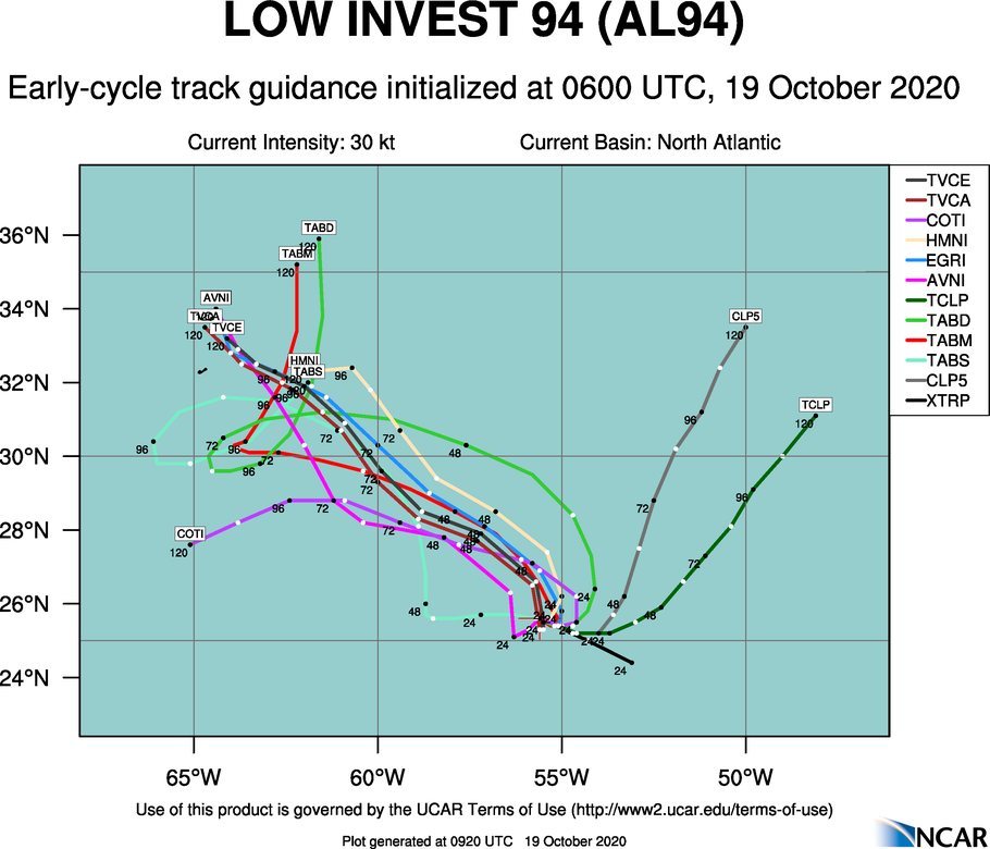
XTRP model is always in the wrong direction, CLP5 takes it NNE, & all other models take 27 towards Bermuda

0 likes
Bill 2015 & Beta 2020
Winter 2020-2021
All observations are in Tecumseh, OK unless otherwise noted.
Winter posts are focused mainly for Oklahoma & Texas.
Take any of my forecasts with a grain of salt, refer to the NWS, SPC, and NHC for official information
Never say Never with weather! Because ANYTHING is possible!
Winter 2020-2021
All observations are in Tecumseh, OK unless otherwise noted.
Winter posts are focused mainly for Oklahoma & Texas.
Take any of my forecasts with a grain of salt, refer to the NWS, SPC, and NHC for official information
Never say Never with weather! Because ANYTHING is possible!

Re: ATL: TWENTY-SEVEN - Models
Iceresistance wrote:XTRP model is always in the wrong direction
0 likes
Eyes: Emily '86, Dean '89, Felix '95, Gert '99, Fabian '03, Humberto '19, Paulette '20
-
Iceresistance
- Category 5
- Posts: 8913
- Age: 20
- Joined: Sat Oct 10, 2020 9:45 am
- Location: Tecumseh, OK/Norman, OK
Re: ATL: TWENTY-SEVEN - Models
plasticup wrote:Iceresistance wrote:XTRP model is always in the wrong direction
It seems like that the XTRP always goes in one direction
(Did you know that Hurricanes Gonzalo & Fay in 2014 were on top of Bermuda? As well as Hurricane Nicole in 2016?)
0 likes
Bill 2015 & Beta 2020
Winter 2020-2021
All observations are in Tecumseh, OK unless otherwise noted.
Winter posts are focused mainly for Oklahoma & Texas.
Take any of my forecasts with a grain of salt, refer to the NWS, SPC, and NHC for official information
Never say Never with weather! Because ANYTHING is possible!
Winter 2020-2021
All observations are in Tecumseh, OK unless otherwise noted.
Winter posts are focused mainly for Oklahoma & Texas.
Take any of my forecasts with a grain of salt, refer to the NWS, SPC, and NHC for official information
Never say Never with weather! Because ANYTHING is possible!
Re: ATL: EPSILON - Models
XTRP stands for "extrapolated" - it is just a linear plot of the current velocity. It is not a model and it is not meant to be predictive of anything.
2 likes
Eyes: Emily '86, Dean '89, Felix '95, Gert '99, Fabian '03, Humberto '19, Paulette '20
Re: ATL: EPSILON - Models
12z GFS has Hurricane Epsilon by tomorrow night or very early Wednesday.
0 likes
Irene '11 Sandy '12 Hermine '16 5/15/2018 Derecho Fay '20 Isaias '20 Elsa '21 Henri '21 Ida '21
I am only a meteorology enthusiast who knows a decent amount about tropical cyclones. Look to the professional mets, the NHC, or your local weather office for the best information.
I am only a meteorology enthusiast who knows a decent amount about tropical cyclones. Look to the professional mets, the NHC, or your local weather office for the best information.
Re: ATL: EPSILON - Models
aspen wrote:12z GFS has Hurricane Epsilon by tomorrow night or very early Wednesday.
12z GFS doesn't reach 64 knots at 10m until 120 hours.
0 likes
Eyes: Emily '86, Dean '89, Felix '95, Gert '99, Fabian '03, Humberto '19, Paulette '20
-
ElectricStorm
- Category 5
- Posts: 4553
- Age: 23
- Joined: Tue Aug 13, 2019 11:23 pm
- Location: Skiatook, OK / Norman, OK
Re: ATL: EPSILON - Models
0z GFS has this a hurricane by 30 hours. Center passes well east of Bermuda. Bottoms out at 967mb.
Last edited by ElectricStorm on Mon Oct 19, 2020 11:12 pm, edited 1 time in total.
0 likes
I am in no way a professional. Take what I say with a grain of salt as I could be totally wrong. Please refer to the NHC, NWS, or SPC for official information.
Boomer Sooner!
Boomer Sooner!

Re: ATL: TWENTY-SEVEN - Models
plasticup wrote:Iceresistance wrote:XTRP model is always in the wrong direction
Post of the season!
0 likes
-
Iceresistance
- Category 5
- Posts: 8913
- Age: 20
- Joined: Sat Oct 10, 2020 9:45 am
- Location: Tecumseh, OK/Norman, OK
Re: ATL: EPSILON - Models
Weather Dude wrote:0z GFS has this a hurricane by 30 hours. Center passes well east of Bermuda. Bottoms out at 967mb.
Up that late!? O_O
I rarely been able to achieve 11 PM time being up nowadays.
0 likes
Bill 2015 & Beta 2020
Winter 2020-2021
All observations are in Tecumseh, OK unless otherwise noted.
Winter posts are focused mainly for Oklahoma & Texas.
Take any of my forecasts with a grain of salt, refer to the NWS, SPC, and NHC for official information
Never say Never with weather! Because ANYTHING is possible!
Winter 2020-2021
All observations are in Tecumseh, OK unless otherwise noted.
Winter posts are focused mainly for Oklahoma & Texas.
Take any of my forecasts with a grain of salt, refer to the NWS, SPC, and NHC for official information
Never say Never with weather! Because ANYTHING is possible!
-
Iceresistance
- Category 5
- Posts: 8913
- Age: 20
- Joined: Sat Oct 10, 2020 9:45 am
- Location: Tecumseh, OK/Norman, OK
Re: ATL: EPSILON - Models
GFS wants a long-lived, but powerful hurricane in the Eastern Caribbean & another one in the Western Caribbean.

0 likes
Bill 2015 & Beta 2020
Winter 2020-2021
All observations are in Tecumseh, OK unless otherwise noted.
Winter posts are focused mainly for Oklahoma & Texas.
Take any of my forecasts with a grain of salt, refer to the NWS, SPC, and NHC for official information
Never say Never with weather! Because ANYTHING is possible!
Winter 2020-2021
All observations are in Tecumseh, OK unless otherwise noted.
Winter posts are focused mainly for Oklahoma & Texas.
Take any of my forecasts with a grain of salt, refer to the NWS, SPC, and NHC for official information
Never say Never with weather! Because ANYTHING is possible!
-
Iceresistance
- Category 5
- Posts: 8913
- Age: 20
- Joined: Sat Oct 10, 2020 9:45 am
- Location: Tecumseh, OK/Norman, OK
Re: ATL: EPSILON - Models
Iceresistance wrote:GFS wants a long-lived, but powerful hurricane in the Eastern Caribbean & another one in the Western Caribbean.
https://www.tropicaltidbits.com/9ba2d475-8b00-4945-91d5-b9ba15608f3c
Bummer! I wished that image existed!
Here is what it was supposed to look like

0 likes
Bill 2015 & Beta 2020
Winter 2020-2021
All observations are in Tecumseh, OK unless otherwise noted.
Winter posts are focused mainly for Oklahoma & Texas.
Take any of my forecasts with a grain of salt, refer to the NWS, SPC, and NHC for official information
Never say Never with weather! Because ANYTHING is possible!
Winter 2020-2021
All observations are in Tecumseh, OK unless otherwise noted.
Winter posts are focused mainly for Oklahoma & Texas.
Take any of my forecasts with a grain of salt, refer to the NWS, SPC, and NHC for official information
Never say Never with weather! Because ANYTHING is possible!

Re: ATL: EPSILON - Models
Iceresistance wrote:Iceresistance wrote:GFS wants a long-lived, but powerful hurricane in the Eastern Caribbean & another one in the Western Caribbean.
https://www.tropicaltidbits.com/9ba2d475-8b00-4945-91d5-b9ba15608f3c
Bummer! I wished that image existed!
Here is what it was supposed to look like
https://www.tropicaltidbits.com/analysis/models/gfs/2020102006/gfs_mslp_pcpn_watl_64.png
Doesn't belong in the Epsilon thread, move to TT.
2 likes
Kendall -> SLO -> PBC
Memorable Storms: Katrina (for its Florida landfall...) Wilma Matthew Irma
Memorable Storms: Katrina (for its Florida landfall...) Wilma Matthew Irma
-
Iceresistance
- Category 5
- Posts: 8913
- Age: 20
- Joined: Sat Oct 10, 2020 9:45 am
- Location: Tecumseh, OK/Norman, OK
Re: ATL: EPSILON - Models
Epsilon's time to become a hurricane is starting to be limited

1 likes
Bill 2015 & Beta 2020
Winter 2020-2021
All observations are in Tecumseh, OK unless otherwise noted.
Winter posts are focused mainly for Oklahoma & Texas.
Take any of my forecasts with a grain of salt, refer to the NWS, SPC, and NHC for official information
Never say Never with weather! Because ANYTHING is possible!
Winter 2020-2021
All observations are in Tecumseh, OK unless otherwise noted.
Winter posts are focused mainly for Oklahoma & Texas.
Take any of my forecasts with a grain of salt, refer to the NWS, SPC, and NHC for official information
Never say Never with weather! Because ANYTHING is possible!
Who is online
Users browsing this forum: No registered users and 74 guests