
ATL: ETA - Models
Moderator: S2k Moderators
-
ColdMiser123

- Professional-Met

- Posts: 778
- Age: 27
- Joined: Mon Sep 26, 2016 3:26 pm
- Location: Northeast US
Re: ATL: ETA - Models
How significant impacts to Tampa are going to be will be highly sensitive on whether this east trend over the last several GFS runs keeps continuing.
2 likes
B.S., M.S., Meteorology & Atmospheric Science

Re: ATL: ETA - Models
From 4 pm NHC Disc:
The initial motion estimate is now northward, or 360/06 kt. The
biggest surprise is the large eastward shift in all of the NHC model
guidance, which was possibly due at least in part to all of the
dropsondes that the NOAA G-IV jet aircraft dropped around Eta
earlier this morning, All of the guidance is now in good agreement
on a broad, deep-layer trough moving eastward across the
south-central and southeastern United States, which will erode the
subtropical ridge to the north of Eta that has been impeding
Eta's poleward progress he past couple of days. This generally
northward to northeastward steering pattern is expected to persist
through the entire 120-h forecast period, with only slight shifts
east or west of he current forecast track due to how vertically deep
Eta remains when it reaches the northeastern Gulf of Mexico and
Apalachee Bay in a few days. The current forecast track maintains
Eta as at least a moderate tropical cyclone through the period, with
only a slight bend back toward the northwest when the system is
expected to interact with an approaching frontal system. The new NHC
track forecast has been shifted about 150 n mi east of the previous
advisory track at 96 and 120 hours, and further eastward shifts in
the track may be required, closer to the consensus models TCVA/TVCN
and NOAA-HCCA.
2 likes
-
jlauderdal
- S2K Supporter

- Posts: 6771
- Joined: Wed May 19, 2004 5:46 am
- Location: NE Fort Lauderdale
- Contact:
Re: RE: Re: ATL: ETA - Models
That looks like a heavy rain setup for sofla...ColdMiser123 wrote:How significant impacts to Tampa are going to be will be highly sensitive on whether this east trend over the last several GFS runs keeps continuing.

1 likes


Re: ATL: ETA - Models
Thats what I get for writing off this storm from my location,could not believe the models would change drastically given all the West trends late couple of days.
0 likes

-
Blown Away

- S2K Supporter
- Posts: 9861
- Joined: Wed May 26, 2004 6:17 am
Re: ATL: ETA - Models
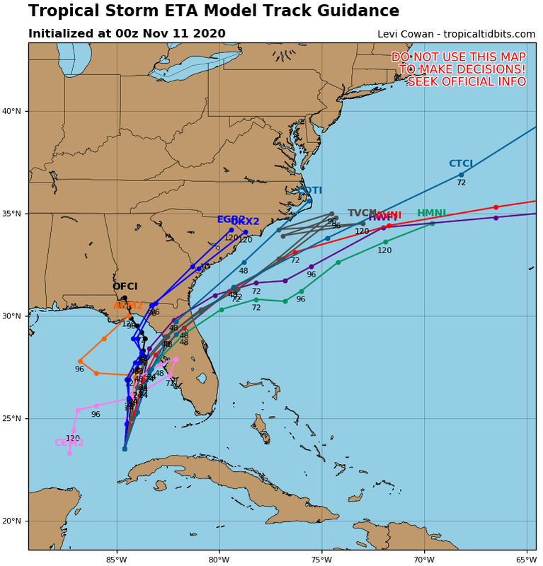
gatorcane wrote:Hello Tampa, shift east from NHC on tap for next update.
https://i.postimg.cc/85GWryqJ/29-L-tracks-00z.png
Man these guidance models have been all over the place with Eta. NHC going to be glad when this storm is over.
1 likes
Hurricane Eye Experience: David 79, Irene 99, Frances 04, Jeanne 04, Wilma 05...
Hurricane Brush Experience: Andrew 92, Erin 95, Floyd 99, Matthew 16, Irma 17, Ian 22, Nicole 22…
Hurricane Brush Experience: Andrew 92, Erin 95, Floyd 99, Matthew 16, Irma 17, Ian 22, Nicole 22…
Re: ATL: ETA - Models
gatorcane wrote:Hello Tampa, shift east from NHC on tap for next update.
https://i.postimg.cc/85GWryqJ/29-L-tracks-00z.png
Yeah Gator even all the mesoscale models are now converging on somewhere between Clearwater and Cedar Key now with my house near landfall. Looks like I'll have to start sand bagging downstairs tomorrow and possibly extend shutters. Hopefully it'll be under hurricane strength but thats not a given as some models bringing it near Tampa latitude in the 970s-980s mb range. This storm may catch alot of people by surprise on the west coast.
4 likes

Re: ATL: ETA - Models
ronjon wrote:gatorcane wrote:Hello Tampa, shift east from NHC on tap for next update.
https://i.postimg.cc/85GWryqJ/29-L-tracks-00z.png
Yeah Gator even all the mesoscale models are now converging on somewhere between Clearwater and Cedar Key now with my house near landfall. Looks like I'll have to start sand bagging downstairs tomorrow and possibly extend shutters. Hopefully it'll be under hurricane strength but thats not a given as some models bringing it near Tampa latitude in the 970s-980s mb range. This storm may catch alot of people by surprise on the west coast.
The entire forecast is based on this becoming a North moving decoupled mess with a naked center. If this manages to come in South of Tampa, the impact will be much different. Might have to hang for the Euro this evening just to get an idea of it follows or comes even more East of GFS.
2 likes
The following post is NOT an official forecast and should not be used as such. It is just the opinion of the poster and may or may not be backed by sound meteorological data. It is NOT endorsed by any professional institution including storm2k.org For Official Information please refer to the NHC and NWS products.
-
Blown Away
- S2K Supporter
- Posts: 9861
- Joined: Wed May 26, 2004 6:17 am
Re: ATL: ETA - Models
ronjon wrote:gatorcane wrote:Hello Tampa, shift east from NHC on tap for next update.
https://i.postimg.cc/85GWryqJ/29-L-tracks-00z.png
Yeah Gator even all the mesoscale models are now converging on somewhere between Clearwater and Cedar Key now with my house near landfall. Looks like I'll have to start sand bagging downstairs tomorrow and possibly extend shutters. Hopefully it'll be under hurricane strength but thats not a given as some models bringing it near Tampa latitude in the 970s-980s mb range. This storm may catch alot of people by surprise on the west coast.
Yeah, storms find their way around Tampa and Cedar Key is a common track. I think strong TS to minimal Cat 1 looks likely.
3 likes
Hurricane Eye Experience: David 79, Irene 99, Frances 04, Jeanne 04, Wilma 05...
Hurricane Brush Experience: Andrew 92, Erin 95, Floyd 99, Matthew 16, Irma 17, Ian 22, Nicole 22…
Hurricane Brush Experience: Andrew 92, Erin 95, Floyd 99, Matthew 16, Irma 17, Ian 22, Nicole 22…

Re: ATL: ETA - Models
gatorcane wrote:Hello Tampa, shift east from NHC on tap for next update.
https://i.postimg.cc/85GWryqJ/29-L-tracks-00z.png
Even the not so good any more UKMET shifted east.
2 likes
-
Blown Away
- S2K Supporter
- Posts: 9861
- Joined: Wed May 26, 2004 6:17 am
Re: ATL: ETA - Models
NDG wrote:gatorcane wrote:Hello Tampa, shift east from NHC on tap for next update.
https://i.postimg.cc/85GWryqJ/29-L-tracks-00z.png
Even the not so good any more UKMET shifted east.
Unless Eta is being heavily sheared, she is clearly moving ENE which is already E of all the 00z early guidance. Lol, It’s like a broken record saying Eta is moving R of the track.
3 likes
Hurricane Eye Experience: David 79, Irene 99, Frances 04, Jeanne 04, Wilma 05...
Hurricane Brush Experience: Andrew 92, Erin 95, Floyd 99, Matthew 16, Irma 17, Ian 22, Nicole 22…
Hurricane Brush Experience: Andrew 92, Erin 95, Floyd 99, Matthew 16, Irma 17, Ian 22, Nicole 22…


Re: ATL: ETA - Models
ronjon wrote:gatorcane wrote:Hello Tampa, shift east from NHC on tap for next update.
https://i.postimg.cc/85GWryqJ/29-L-tracks-00z.png
Yeah Gator even all the mesoscale models are now converging on somewhere between Clearwater and Cedar Key now with my house near landfall. Looks like I'll have to start sand bagging downstairs tomorrow and possibly extend shutters. Hopefully it'll be under hurricane strength but thats not a given as some models bringing it near Tampa latitude in the 970s-980s mb range. This storm may catch alot of people by surprise on the west coast.
Well, down near Charlotte County, we watched Charley's quick turn too.
Even if this storm doesn't find the Peace River, like Charley did, and does make a beeline for Sarasota, we are on the "dirty side" of it, and if it's a full-blown hurricane, we'll have a rough ride.
Trouble is, we are not living in a good, stout house, like we were in Charley. "Downsized," don'cha know? ANd now I wonder WTH I was thinking!
Holdin' our breath here.
4 likes
Cleo - 1964, Betsy - 1965, David - 1979, Andrew - 1992, Charlie (Francis, Ivan, Jeanne) - 2004, Irma - 2017, Ian - 2022
-
Hypercane_Kyle

- Category 5

- Posts: 2899
- Joined: Sat Mar 07, 2015 7:58 pm
- Location: Cape Canaveral, FL
Re: ATL: ETA - Models
Watching closely the trends here in Tampa... seems like 28N is the furthest this thing can go without getting decapitated. If it can manage to squeak in a landfall just south of Tampa, odds increase of strong tropical storm impacts in Tampa.
1 likes
My posts are my own personal opinion, defer to the National Hurricane Center (NHC) and other NOAA products for decision making during hurricane season.
-
ElectricStorm

- Category 5
- Posts: 4529
- Age: 23
- Joined: Tue Aug 13, 2019 11:23 pm
- Location: Skiatook, OK / Norman, OK
Re: ATL: ETA - Models
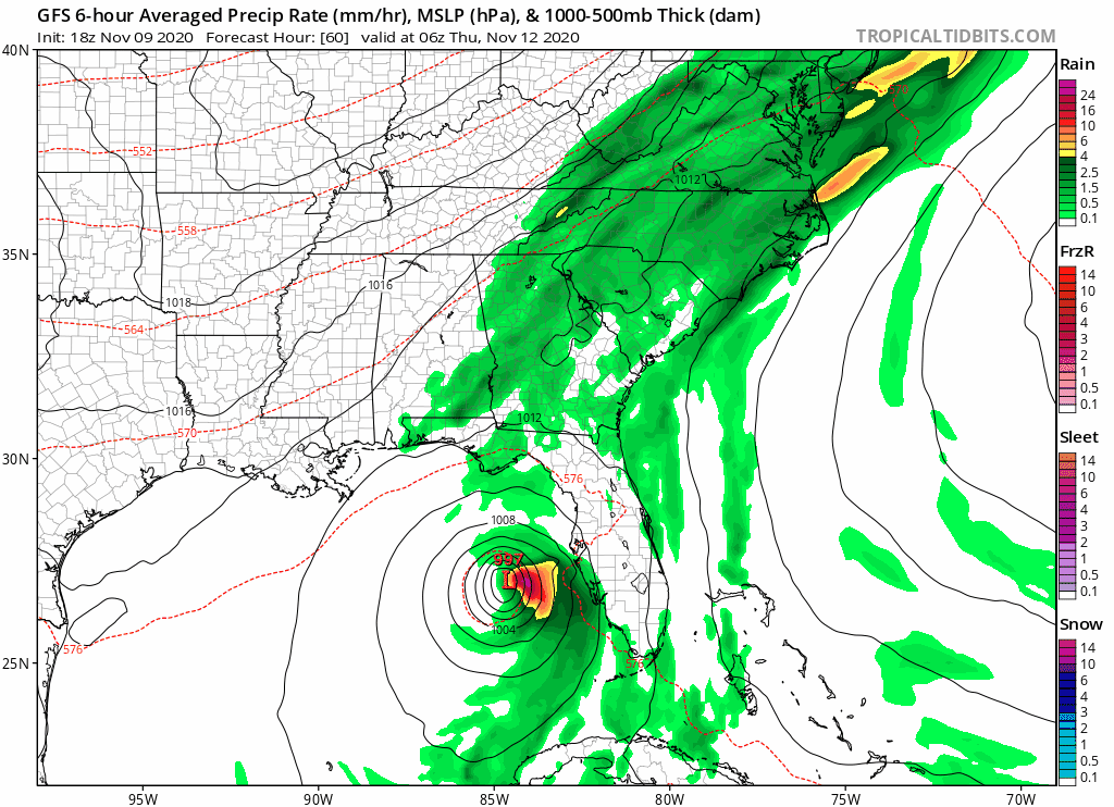
HMON/HWRF have a similar track north of Tampa, HWRF peaks as a lower end Cat 1. HMON peaks as and upper Cat 1/low Cat 2. Both of them have Eta weakening before landfall.
3 likes
I am in no way a professional. Take what I say with a grain of salt as I could be totally wrong. Please refer to the NHC, NWS, or SPC for official information.
Boomer Sooner!
Boomer Sooner!
Re: ATL: ETA - Models
Euro run initialized way to far West.
0 likes
The following post is NOT an official forecast and should not be used as such. It is just the opinion of the poster and may or may not be backed by sound meteorological data. It is NOT endorsed by any professional institution including storm2k.org For Official Information please refer to the NHC and NWS products.
Re: ATL: ETA - Models
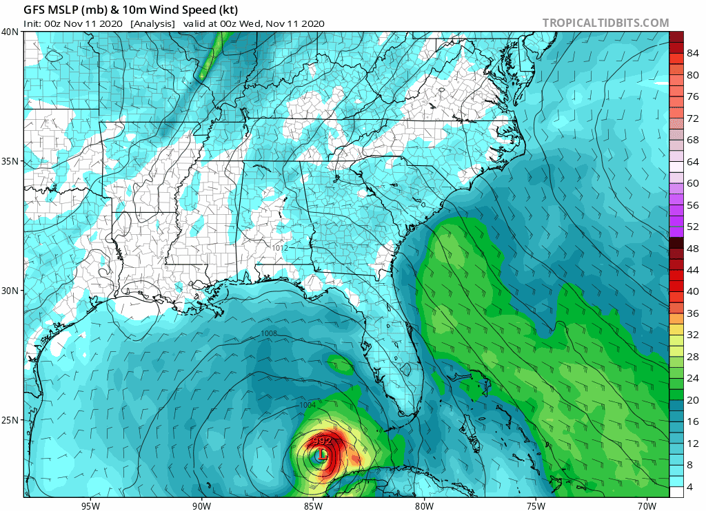
According to the latest 06z HWRF Eta already peaked this morning, a slow weakening during the day today.
Convection refiring later this afternoon and evening but weaker by then.
Convection refiring later this afternoon and evening but weaker by then.
3 likes
Who is online
Users browsing this forum: No registered users and 69 guests