WPAC: VAMCO - Post-Tropical

Moderator: S2k Moderators

Message
Author
User avatar
euro6208
Category 5
Category 5
Posts: 18547
Joined: Mon Mar 08, 2004 7:50 pm
Location: Guam

Re: WPAC: VAMCO - Severe Tropical Storm

#101 Postby euro6208 » Tue Nov 10, 2020 10:20 pm

aspen wrote:
euro6208 wrote:Sunrise over Vamco

https://i.imgur.com/9MUWKoD.gif

Where did you get that image? I know ssd.noaa.gov had eastern hemisphere cyclone images in that exact format, but the site hasn’t been working since the spring.


https://www.ssd.noaa.gov/PS/TROP/storms/VAMCO.html

It's working now.
0 likes   
Remember, all of my post aren't official. For official warnings and discussions, Please refer to your local NWS products...

NWS for the Western Pacific

https://www.weather.gov/gum/

User avatar
1900hurricane
Category 5
Category 5
Posts: 6044
Age: 32
Joined: Fri Feb 06, 2015 12:04 pm
Location: Houston, TX
Contact:

Re: WPAC: VAMCO - Typhoon

#102 Postby 1900hurricane » Tue Nov 10, 2020 10:27 pm

Pretty big core developing here. Think Vamco had the potential to become high end if it weren't making landfall so soon, but it still has a chance to get pretty strong regardless.

Image
1 likes   
Contract Meteorologist. TAMU & MSST. Fiercely authentic, one of a kind. We are all given free will, so choose a life meant to be lived. We are the Masters of our own Stories.
Opinions expressed are mine alone.

Follow me on Twitter at @1900hurricane : Read blogs at https://1900hurricane.wordpress.com/

User avatar
mrbagyo
Category 5
Category 5
Posts: 3613
Age: 31
Joined: Thu Apr 12, 2012 9:18 am
Location: 14.13N 120.98E
Contact:

Re: WPAC: VAMCO - Typhoon

#103 Postby mrbagyo » Tue Nov 10, 2020 10:53 pm

Just north of Catanduanes
Image
0 likes   
The posts in this forum are NOT official forecast and should not be used as such. They are just the opinion of the poster and may or may not be backed by sound meteorological data. They are NOT endorsed by any professional institution or storm2k.org. For official information, please refer to RSMC, NHC and NWS products.

User avatar
mrbagyo
Category 5
Category 5
Posts: 3613
Age: 31
Joined: Thu Apr 12, 2012 9:18 am
Location: 14.13N 120.98E
Contact:

Re: WPAC: VAMCO - Typhoon

#104 Postby mrbagyo » Wed Nov 11, 2020 1:02 am

Image
0 likes   
The posts in this forum are NOT official forecast and should not be used as such. They are just the opinion of the poster and may or may not be backed by sound meteorological data. They are NOT endorsed by any professional institution or storm2k.org. For official information, please refer to RSMC, NHC and NWS products.

User avatar
mrbagyo
Category 5
Category 5
Posts: 3613
Age: 31
Joined: Thu Apr 12, 2012 9:18 am
Location: 14.13N 120.98E
Contact:

Re: WPAC: VAMCO - Typhoon

#105 Postby mrbagyo » Wed Nov 11, 2020 1:08 am

988.57 hPa - 1:30 PM - Daet, Camarines Norte

Image
0 likes   
The posts in this forum are NOT official forecast and should not be used as such. They are just the opinion of the poster and may or may not be backed by sound meteorological data. They are NOT endorsed by any professional institution or storm2k.org. For official information, please refer to RSMC, NHC and NWS products.

User avatar
mrbagyo
Category 5
Category 5
Posts: 3613
Age: 31
Joined: Thu Apr 12, 2012 9:18 am
Location: 14.13N 120.98E
Contact:

Re: WPAC: VAMCO - Typhoon

#106 Postby mrbagyo » Wed Nov 11, 2020 1:49 am

JMA upped it to 70 knots
- peak 80 knots before touch down


TY 2022 (Vamco)
Issued at 06:45 UTC, 11 November 2020

<Analysis at 06 UTC, 11 November>
Scale -
Intensity -
Center position N14°25' (14.4°)
E123°30' (123.5°)
Direction and speed of movement W 20 km/h (10 kt)
Central pressure 970 hPa
Maximum wind speed near center 35 m/s (70 kt)
Maximum wind gust speed 50 m/s (100 kt)
≥ 50 kt wind area ALL 110 km (60 NM)
≥ 30 kt wind area N 440 km (240 NM)
S 280 km (150 NM)

<Forecast for 18 UTC, 11 November>
Intensity -
Center position of probability circle N15°10' (15.2°)
E121°25' (121.4°)
Direction and speed of movement W 20 km/h (11 kt)
Central pressure 955 hPa
Maximum wind speed near center 40 m/s (80 kt)
Maximum wind gust speed 60 m/s (115 kt)
Radius of probability circle 65 km (35 NM)
Storm warning area ALL 200 km (110 NM)
0 likes   
The posts in this forum are NOT official forecast and should not be used as such. They are just the opinion of the poster and may or may not be backed by sound meteorological data. They are NOT endorsed by any professional institution or storm2k.org. For official information, please refer to RSMC, NHC and NWS products.

User avatar
doomhaMwx
Category 5
Category 5
Posts: 2396
Age: 25
Joined: Tue Apr 18, 2017 4:01 am
Location: Baguio/Benguet, Philippines
Contact:

Re: WPAC: VAMCO - Typhoon

#107 Postby doomhaMwx » Wed Nov 11, 2020 2:08 am

25W VAMCO 201111 0600 14.6N 123.4E WPAC 80 975
0 likes   
Like my content? Consider giving a tip.

User avatar
mrbagyo
Category 5
Category 5
Posts: 3613
Age: 31
Joined: Thu Apr 12, 2012 9:18 am
Location: 14.13N 120.98E
Contact:

Re: WPAC: VAMCO - Typhoon

#108 Postby mrbagyo » Wed Nov 11, 2020 3:39 am

Image

Forward speed has slowed down - Daet pressure barely moving. Vamco would probably start moving WNW
0 likes   
The posts in this forum are NOT official forecast and should not be used as such. They are just the opinion of the poster and may or may not be backed by sound meteorological data. They are NOT endorsed by any professional institution or storm2k.org. For official information, please refer to RSMC, NHC and NWS products.

User avatar
euro6208
Category 5
Category 5
Posts: 18547
Joined: Mon Mar 08, 2004 7:50 pm
Location: Guam

Re: WPAC: VAMCO - Typhoon

#109 Postby euro6208 » Wed Nov 11, 2020 4:31 am

CI# /Pressure/ Vmax
4.8 / 973.2mb/ 84.8kt


Final T# Adj T# Raw T#
4.7 5.7 5.7
0 likes   
Remember, all of my post aren't official. For official warnings and discussions, Please refer to your local NWS products...

NWS for the Western Pacific

https://www.weather.gov/gum/

Thon1357
Tropical Low
Tropical Low
Posts: 16
Age: 36
Joined: Sun Dec 25, 2016 4:52 am
Location: Philippines

Re: WPAC: VAMCO - Typhoon

#110 Postby Thon1357 » Wed Nov 11, 2020 6:18 am

This typhoon has been on us since morning until now here in Legazpi City. Despite the center being far away from us. This storm is huge and seems to be moving slowly right now. PAGASA forecasted landfall between 6-8pm on Polillo Island but based on satellite pics it seems it is still over waters near Camarines Norte as of this time. I think this will cause more damage than Goni despite not being an STY, due to the large diameter and slow movement. The rains are also quite heavier than Goni's, reports of flooding all over Albay has been reported starting this afternoon including a possible lahar flow warning from Philvolcs
0 likes   

User avatar
mrbagyo
Category 5
Category 5
Posts: 3613
Age: 31
Joined: Thu Apr 12, 2012 9:18 am
Location: 14.13N 120.98E
Contact:

Re: WPAC: VAMCO - Typhoon

#111 Postby mrbagyo » Wed Nov 11, 2020 7:20 am

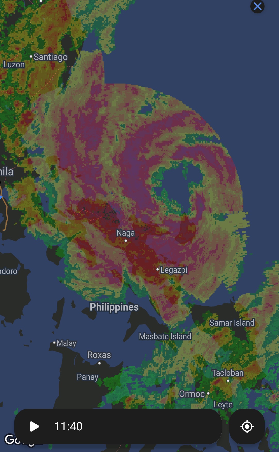
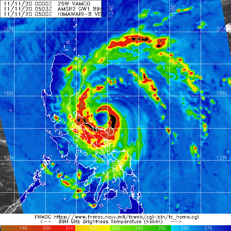
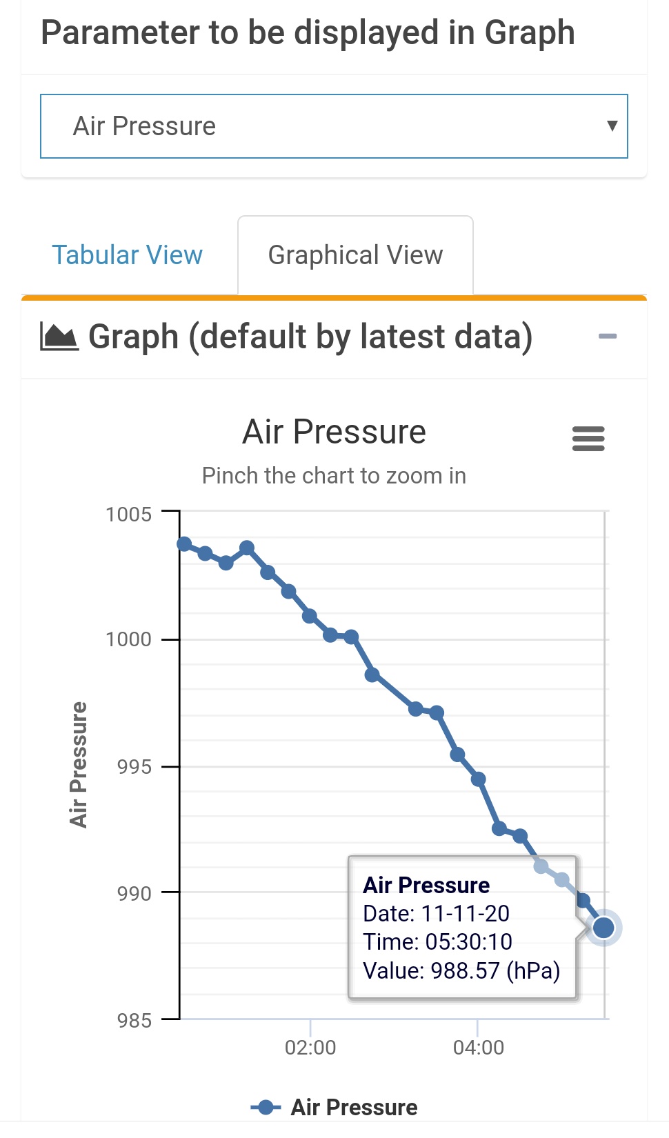
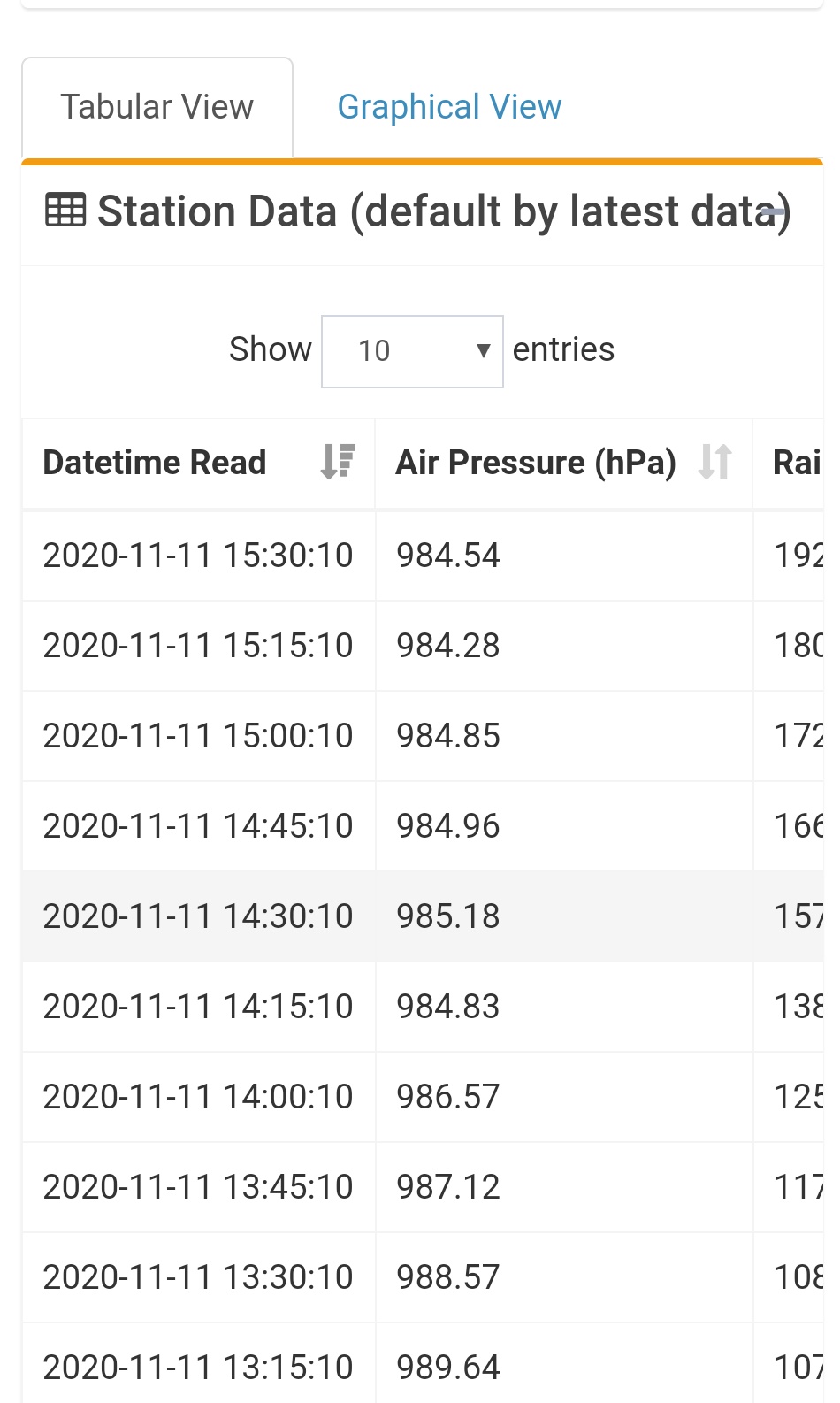
Thon1357 wrote:This typhoon has been on us since morning until now here in Legazpi City. Despite the center being far away from us. This storm is huge and seems to be moving slowly right now. PAGASA forecasted landfall between 6-8pm on Polillo Island but based on satellite pics it seems it is still over waters near Camarines Norte as of this time. I think this will cause more damage than Goni despite not being an STY, due to the large diameter and slow movement. The rains are also quite heavier than Goni's, reports of flooding all over Albay has been reported starting this afternoon including a possible lahar flow warning from Philvolcs


Yeah, it did slow down considerably. Now, it's crawling WNW based on latest radar animation.

Lots of places are now flooded in the Bicol region- Daet has already seen 350 mm today (add the 107mm yesterday and thats >450 mm within 2 days).
Stay safe mate! This too shall pass.
1 likes   
The posts in this forum are NOT official forecast and should not be used as such. They are just the opinion of the poster and may or may not be backed by sound meteorological data. They are NOT endorsed by any professional institution or storm2k.org. For official information, please refer to RSMC, NHC and NWS products.

User avatar
mrbagyo
Category 5
Category 5
Posts: 3613
Age: 31
Joined: Thu Apr 12, 2012 9:18 am
Location: 14.13N 120.98E
Contact:

Re: WPAC: VAMCO - Typhoon

#112 Postby mrbagyo » Wed Nov 11, 2020 7:21 am

0 likes   
The posts in this forum are NOT official forecast and should not be used as such. They are just the opinion of the poster and may or may not be backed by sound meteorological data. They are NOT endorsed by any professional institution or storm2k.org. For official information, please refer to RSMC, NHC and NWS products.

User avatar
Hayabusa
Category 5
Category 5
Posts: 3735
Joined: Sun Sep 16, 2018 1:05 pm

Re: WPAC: VAMCO - Typhoon

#113 Postby Hayabusa » Wed Nov 11, 2020 7:43 am

90 knots?
TPPN12 PGTW 111226

A. TYPHOON 25W (VAMCO)

B. 11/1150Z

C. 14.48N

D. 122.82E

E. THREE/HMWRI8

F. T5.0/5.0/D2.0/24HRS STT: D0.5/03HRS

G. IR/EIR

H. REMARKS: 09A/PBO RAGGED EYE/ANMTN. OW EYE SURROUNDED BY LG
YIELDS AN E# AND DT (NO EYE ADJUSTMENT) OF 5.0. MET AND PT
YIELDS A 4.5. DBO DT.

I. ADDITIONAL POSITIONS: NONE


ELIAS
0 likes   
ヤンデレ女が寝取られるているのを見たい!!!
ECMWF ensemble NWPAC plots: https://ecmwfensnwpac.imgbb.com/
Multimodel NWPAC plots: https://multimodelnwpac.imgbb.com/
GFS Ensemble NWPAC plots (16 & 35 day forecast): https://gefsnwpac.imgbb.com/
Plots updated automatically

User avatar
euro6208
Category 5
Category 5
Posts: 18547
Joined: Mon Mar 08, 2004 7:50 pm
Location: Guam

Re: WPAC: VAMCO - Typhoon

#114 Postby euro6208 » Wed Nov 11, 2020 7:50 am

90 to 95 knots seems reasonable.

CURRENT ESTIMATE
Date (mmddhhmm): 11110505
SATCON: MSLP = 963 hPa MSW = 93 knots
SATCON Member Consensus: 91.0 knots
Pressure -> Wind Using SATCON MSLP: 93 knots
Distance to Outer Closed Isobar Used is 210 nm
Eye Size Correction Used is 0 knots Source: NA
0 likes   
Remember, all of my post aren't official. For official warnings and discussions, Please refer to your local NWS products...

NWS for the Western Pacific

https://www.weather.gov/gum/

User avatar
euro6208
Category 5
Category 5
Posts: 18547
Joined: Mon Mar 08, 2004 7:50 pm
Location: Guam

Re: WPAC: VAMCO - Typhoon

#115 Postby euro6208 » Wed Nov 11, 2020 7:51 am

Image
0 likes   
Remember, all of my post aren't official. For official warnings and discussions, Please refer to your local NWS products...

NWS for the Western Pacific

https://www.weather.gov/gum/

User avatar
Hayabusa
Category 5
Category 5
Posts: 3735
Joined: Sun Sep 16, 2018 1:05 pm

Re: WPAC: VAMCO - Typhoon

#116 Postby Hayabusa » Wed Nov 11, 2020 8:37 am

Image
0 likes   
ヤンデレ女が寝取られるているのを見たい!!!
ECMWF ensemble NWPAC plots: https://ecmwfensnwpac.imgbb.com/
Multimodel NWPAC plots: https://multimodelnwpac.imgbb.com/
GFS Ensemble NWPAC plots (16 & 35 day forecast): https://gefsnwpac.imgbb.com/
Plots updated automatically

User avatar
mrbagyo
Category 5
Category 5
Posts: 3613
Age: 31
Joined: Thu Apr 12, 2012 9:18 am
Location: 14.13N 120.98E
Contact:

Re: WPAC: VAMCO - Typhoon

#117 Postby mrbagyo » Wed Nov 11, 2020 9:40 am

Image
0 likes   
The posts in this forum are NOT official forecast and should not be used as such. They are just the opinion of the poster and may or may not be backed by sound meteorological data. They are NOT endorsed by any professional institution or storm2k.org. For official information, please refer to RSMC, NHC and NWS products.

User avatar
mrbagyo
Category 5
Category 5
Posts: 3613
Age: 31
Joined: Thu Apr 12, 2012 9:18 am
Location: 14.13N 120.98E
Contact:

Re: WPAC: VAMCO - Typhoon

#118 Postby mrbagyo » Wed Nov 11, 2020 10:12 am

Double digit positive eye temp
2020NOV11 143000 5.4 960.3 99.6 5.4 6.1 6.1 NO LIMIT OFF OFF OFF OFF 14.70 -68.06 EYE
0 likes   
The posts in this forum are NOT official forecast and should not be used as such. They are just the opinion of the poster and may or may not be backed by sound meteorological data. They are NOT endorsed by any professional institution or storm2k.org. For official information, please refer to RSMC, NHC and NWS products.

User avatar
euro6208
Category 5
Category 5
Posts: 18547
Joined: Mon Mar 08, 2004 7:50 pm
Location: Guam

Re: WPAC: VAMCO - Typhoon

#119 Postby euro6208 » Wed Nov 11, 2020 10:28 am

Close up of JTWC track.

Image

Image
0 likes   
Remember, all of my post aren't official. For official warnings and discussions, Please refer to your local NWS products...

NWS for the Western Pacific

https://www.weather.gov/gum/

User avatar
ManilaTC
WesternPacificWeather.com
Posts: 592
Age: 45
Joined: Mon Oct 26, 2009 5:13 am
Location: Mandaluyong City, Philippines
Contact:

Re: WPAC: VAMCO - Typhoon

#120 Postby ManilaTC » Wed Nov 11, 2020 10:29 am

Its getting bad now... roofs are banging...
0 likes   
The above post is NOT official and should not be used as such. It is my opinion and may or may not be backed by sound meteorological data. It is not endorsed by any professional institution or storm2k.org. Please refer to your official national weather agency.

WEB http://goo.gl/JDiKXB | FB https://goo.gl/N5sIle | @ManilaTC


Return to “2020”

Who is online

Users browsing this forum: No registered users and 8 guests