http://twitter.com/drrickknabb/status/1424358976880250880
ATL: FRED - Post-Tropical - Discussion
Moderator: S2k Moderators
-
toad strangler

- S2K Supporter

- Posts: 4176
- Joined: Sun Jul 28, 2013 3:09 pm
- Location: Earth
- Contact:
Re: ATL: INVEST 94L - Discussion
5 likes
-
Hurricaneman

- Category 5

- Posts: 7284
- Age: 43
- Joined: Tue Aug 31, 2004 3:24 pm
- Location: central florida
Re: ATL: INVEST 94L - Discussion
Someone earlier in the thread mentioned that the low could congeal more towards the ball of convection to the WSW, if that happens could it be possible that this misses Hispaniola to the south, it can’t be ruled out a similar track to Elsa
1 likes

Re: ATL: INVEST 94L - Discussion
toad strangler wrote:http://twitter.com/drrickknabb/status/1424358976880250880?s=21
Pretty interesting reading between the lines.
This is what I am concerned about.
If the ULL over FL breaks down, intensification could be dramatic especially with the other ULL, NE of the LL vort, supporting outflow.
A big kicker would be if it taps into the EPAC moisture.
I am not seeing anything forming in the EPAC then to steal TPW away.
2 likes
-
Category5Kaiju

- Category 5
- Posts: 3417
- Age: 22
- Joined: Thu Dec 24, 2020 12:45 pm
- Location: Seattle
Re: ATL: INVEST 94L - Discussion
Hurricaneman wrote:Someone earlier in the thread mentioned that the low could congeal more towards the ball of convection to the WSW, if that happens could it be possible that this misses Hispaniola to the south, it can’t be ruled out a similar track to Elsa
Or Laura. Not saying we will see a 150 mph Gulf storm of course, but Laura was expected to be a Florida Strait storm until it wasn't and was far enough to the south to become a Western Gulf threat.
0 likes
Unless explicitly stated, all information covered in my posts is based on my opinions and observations. Please refer to a professional meteorologist or an accredited weather research agency otherwise, especially if serious decisions must be made in the event of a potentially life-threatening tropical storm or hurricane.
-
Shell Mound
- Category 5
- Posts: 2434
- Age: 31
- Joined: Thu Sep 07, 2017 3:39 pm
- Location: St. Petersburg, FL → Scandinavia
Re: ATL: INVEST 94L - Discussion

I am still rather skeptical that this manages to intensify much within the next three days, simply due to the very stable air mass that lurks just beyond the ITCZ. Small systems tend to die rapidly as soon as they detach themselves from the ITCZ and encounter mid-level dry air. GOES-16 WV imagery indicates that the air mass to the immediate northwest of 94L is in a very parched percentile—nearly record-breaking for its coordinates and time of year. As soon as 94L begins to gain latitude near the Lesser Antilles it may very well die off due to dry air alone, even if UL conditions remain rather favourable in the immediate vicinity of the Leeward Islands.
2 likes
CVW / MiamiensisWx / Shell Mound
The posts in this forum are NOT official forecasts and should not be used as such. They are just the opinion of the poster and may or may not be backed by sound meteorological data. They are NOT endorsed by any professional institution or STORM2K. For official information, please refer to products from the NHC and NWS.
-
Aric Dunn
- Category 5
- Posts: 21228
- Age: 41
- Joined: Sun Sep 19, 2004 9:58 pm
- Location: Ready for the Chase.
- Contact:
Re: ATL: INVEST 94L - Discussion
just waking up...
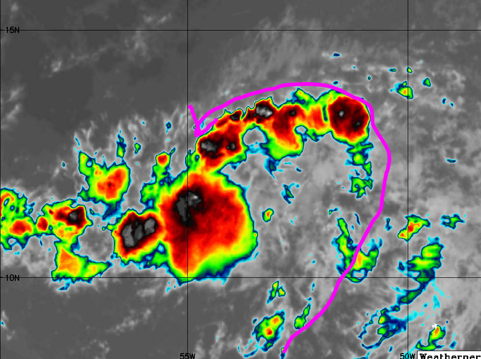
Wrapping up quite nicely. I can see two vort maxes ( still pretty normal at this point of development) the vort max to the South looks to be the main one as the vort to the north is rotating around the other.
should quickly consolidate today.

Wrapping up quite nicely. I can see two vort maxes ( still pretty normal at this point of development) the vort max to the South looks to be the main one as the vort to the north is rotating around the other.
should quickly consolidate today.
12 likes
Note: If I make a post that is brief. Please refer back to previous posts for the analysis or reasoning. I do not re-write/qoute what my initial post said each time.
If there is nothing before... then just ask
Space & Atmospheric Physicist, Embry-Riddle Aeronautical University,
I believe the sky is falling...
If there is nothing before... then just ask
Space & Atmospheric Physicist, Embry-Riddle Aeronautical University,
I believe the sky is falling...
-
Blown Away

- S2K Supporter
- Posts: 9870
- Joined: Wed May 26, 2004 6:17 am
Re: ATL: INVEST 94L - Discussion
Aric Dunn wrote:just waking up...
Wrapping up quite nicely. I can see two vort maxes ( still pretty normal at this point of development) the vort max to the South looks to be the main one as the vort to the is rotating around the other.
should quickly consolidate today.
https://i.ibb.co/NTHQ7Tg/Capture.png
Do you think this L will go N of Hispaniola??
Last edited by Blown Away on Sun Aug 08, 2021 10:48 am, edited 1 time in total.
0 likes
Hurricane Eye Experience: David 79, Irene 99, Frances 04, Jeanne 04, Wilma 05... EYE COMING MY WAY IN 2024…
Hurricane Brush Experience: Andrew 92, Erin 95, Floyd 99, Matthew 16, Irma 17, Ian 22, Nicole 22…
Hurricane Brush Experience: Andrew 92, Erin 95, Floyd 99, Matthew 16, Irma 17, Ian 22, Nicole 22…

Re: ATL: INVEST 94L - Discussion
Aric Dunn wrote:just waking up...
Wrapping up quite nicely. I can see two vort maxes ( still pretty normal at this point of development) the vort max to the South looks to be the main one as the vort to the north is rotating around the other.
should quickly consolidate today.
https://i.ibb.co/NTHQ7Tg/Capture.png
I'm eagerly awaiting Wxman's rebuttal.
6 likes
Re: ATL: INVEST 94L - Discussion
abajan wrote:Aric Dunn wrote:just waking up...
Wrapping up quite nicely. I can see two vort maxes ( still pretty normal at this point of development) the vort max to the South looks to be the main one as the vort to the north is rotating around the other.
should quickly consolidate today.
https://i.ibb.co/NTHQ7Tg/Capture.png
I'm eagerly awaiting Wxman's rebuttal.
Don't forget about complaints of cutting into his PTO
5 likes
Re: ATL: INVEST 94L - Discussion
Compare 94L's pressure at 6z vs 12z:


Assuming it were to keep falling at that rate, could we be looking at a tropical depression by this afternoon?
Assuming it were to keep falling at that rate, could we be looking at a tropical depression by this afternoon?
3 likes
-
SouthDadeFish

- Professional-Met

- Posts: 2835
- Joined: Thu Sep 23, 2010 2:54 pm
- Location: Miami, FL
- Contact:
Re: ATL: INVEST 94L - Discussion
Looks like an elongated strip of vorticity to me. Convectively, it is not very organized. I don't see any banding, only forced convergence along the trough axis. There's a lot of dry air in it's path, which is significantly limiting any convection on the N and W sides of the trough axis. Perhaps we see a run at organization tonight during the typical diurnal maximum, but it I would argue it looked better organized convectively yesterday.
5 likes

Re: ATL: INVEST 94L - Discussion
The southern convection is pushing SW and dying out, the northern vorticity is clearly taking over.

8 likes
-
Aric Dunn
- Category 5
- Posts: 21228
- Age: 41
- Joined: Sun Sep 19, 2004 9:58 pm
- Location: Ready for the Chase.
- Contact:
Re: ATL: INVEST 94L - Discussion
We have what about 24 hours to barbados.. could see a PTC tonight if convection continues to increase and maintain.
3 likes
Note: If I make a post that is brief. Please refer back to previous posts for the analysis or reasoning. I do not re-write/qoute what my initial post said each time.
If there is nothing before... then just ask
Space & Atmospheric Physicist, Embry-Riddle Aeronautical University,
I believe the sky is falling...
If there is nothing before... then just ask
Space & Atmospheric Physicist, Embry-Riddle Aeronautical University,
I believe the sky is falling...
-
Sciencerocks
- Category 5
- Posts: 7294
- Age: 38
- Joined: Thu Jul 06, 2017 1:51 am

-
Spacecoast

- Category 2

- Posts: 687
- Joined: Thu Aug 31, 2017 2:03 pm

-
Spacecoast
- Category 2
- Posts: 687
- Joined: Thu Aug 31, 2017 2:03 pm

-
Shell Mound
- Category 5
- Posts: 2434
- Age: 31
- Joined: Thu Sep 07, 2017 3:39 pm
- Location: St. Petersburg, FL → Scandinavia
Re: ATL: INVEST 94L - Discussion
SouthDadeFish wrote:There's a lot of dry air in its path, which is significantly limiting any convection on the N and W sides of the trough axis..
I suspect that the dry air alone is likely to keep 94L from developing within the next two to three days. Afterward, shear might do in whatever’s left. We shall see.
Last edited by Shell Mound on Sun Aug 08, 2021 11:51 am, edited 1 time in total.
0 likes
CVW / MiamiensisWx / Shell Mound
The posts in this forum are NOT official forecasts and should not be used as such. They are just the opinion of the poster and may or may not be backed by sound meteorological data. They are NOT endorsed by any professional institution or STORM2K. For official information, please refer to products from the NHC and NWS.
Re: ATL: INVEST 94L - Discussion
Aric Dunn wrote:We have what about 24 hours to barbados.. could see a PTC tonight if convection continues to increase and maintain.
All global models have the vorticity tracking to the north of Barbados, if true they shouldn't see much winds out of it unlike with Elsa.
3 likes
-
Aric Dunn
- Category 5
- Posts: 21228
- Age: 41
- Joined: Sun Sep 19, 2004 9:58 pm
- Location: Ready for the Chase.
- Contact:
Re: ATL: INVEST 94L - Discussion
NDG wrote:Aric Dunn wrote:We have what about 24 hours to barbados.. could see a PTC tonight if convection continues to increase and maintain.
All global models have the vorticity tracking to the north of Barbados, if true they shouldn't see much winds out of it unlike with Elsa.
I Have been discussing this elsewhere. and the models have been showing a wnw/nw sharp motion to occur ... it needs to do that soon.
right now there is no reason for the turn.. and it is chugging West pretty steady.
so barbados is still in the path for now.
it is still E/ESE of barbados. and less than 24 hours away.. going to have a tough time missing it.

3 likes
Note: If I make a post that is brief. Please refer back to previous posts for the analysis or reasoning. I do not re-write/qoute what my initial post said each time.
If there is nothing before... then just ask
Space & Atmospheric Physicist, Embry-Riddle Aeronautical University,
I believe the sky is falling...
If there is nothing before... then just ask
Space & Atmospheric Physicist, Embry-Riddle Aeronautical University,
I believe the sky is falling...
Who is online
Users browsing this forum: No registered users and 4 guests