ATL: FRED - Models

Moderator: S2k Moderators

Message
Author
User avatar
Category5Kaiju
Category 5
Category 5
Posts: 3402
Age: 22
Joined: Thu Dec 24, 2020 12:45 pm
Location: Seattle

Re: ATL: 94L - Models

#21 Postby Category5Kaiju » Sun Aug 08, 2021 12:39 pm

Blown Away wrote:
Shell Mound wrote:
NDG wrote:So far through 18 hrs 12z HWRF shows the dry air to the NW of 94L keep pushing west out of the way of 94L.

https://i.imgur.com/2ZDFasQ.png

https://i.ibb.co/C694jJM/Hurricane-1.png
Given the current level of disorganisation, this seems highly unlikely. 94L’s circulation is quite tilted with height, so the HWRF’s solution seems unrealistic.


Yes HWRF tends to overplay intensity, but seems to be remarkably good with the IR Brightness predictions...


But when the HWRF predicts RI and RI actually does occur, oh boy do I think it's arguably the best tool we currently have to see just how powerful a given RI storm could get.
0 likes   
Unless explicitly stated, all information covered in my posts is based on my opinions and observations. Please refer to a professional meteorologist or an accredited weather research agency otherwise, especially if serious decisions must be made in the event of a potentially life-threatening tropical storm or hurricane.

Shell Mound
Category 5
Category 5
Posts: 2434
Age: 31
Joined: Thu Sep 07, 2017 3:39 pm
Location: St. Petersburg, FL → Scandinavia

Re: ATL: 94L - Models

#22 Postby Shell Mound » Sun Aug 08, 2021 12:40 pm

Category5Kaiju wrote:
Blown Away wrote:
Shell Mound wrote:https://i.ibb.co/C694jJM/Hurricane-1.png
Given the current level of disorganisation, this seems highly unlikely. 94L’s circulation is quite tilted with height, so the HWRF’s solution seems unrealistic.


Yes HWRF tends to overplay intensity, but seems to be remarkably good with the IR Brightness predictions...

But when the HWRF predicts RI and RI actually does occur, oh boy do I think it's arguably the best tool we currently have to see just how powerful a given RI storm could get.

The HWRF usually is most adept at forecasting RI under ideal or near-ideal conditions. Under marginal conditions, including 94L’s, it becomes much more suspect.
0 likes   
CVW / MiamiensisWx / Shell Mound
The posts in this forum are NOT official forecasts and should not be used as such. They are just the opinion of the poster and may or may not be backed by sound meteorological data. They are NOT endorsed by any professional institution or STORM2K. For official information, please refer to products from the NHC and NWS.

User avatar
Hypercane_Kyle
Category 5
Category 5
Posts: 2900
Joined: Sat Mar 07, 2015 7:58 pm
Location: Cape Canaveral, FL

Re: ATL: 94L - Models

#23 Postby Hypercane_Kyle » Sun Aug 08, 2021 12:41 pm

Much slower moving than Elsa, thanks to slower trades this time of year.
6 likes   
My posts are my own personal opinion, defer to the National Hurricane Center (NHC) and other NOAA products for decision making during hurricane season.

User avatar
aspen
Category 5
Category 5
Posts: 8057
Joined: Sat Oct 12, 2019 7:10 pm
Location: Connecticut, USA

Re: ATL: 94L - Models

#24 Postby aspen » Sun Aug 08, 2021 12:58 pm

Shell Mound wrote:
Category5Kaiju wrote:
Blown Away wrote:
Yes HWRF tends to overplay intensity, but seems to be remarkably good with the IR Brightness predictions...

But when the HWRF predicts RI and RI actually does occur, oh boy do I think it's arguably the best tool we currently have to see just how powerful a given RI storm could get.

The HWRF usually is most adept at forecasting RI under ideal or near-ideal conditions. Under marginal conditions, including 94L’s, it becomes much more suspect.

I wouldn’t call this a significant phase of RI; 94L only peaks as a mid to high 980s Cat 1 before running into Hispaniola a d getting ripped to shreds. That seems like a pretty reasonable outcome, instead of a Cat 3 like Gonzalo or Elsa. Speaking of Elsa, 94L is moving slower and has to deal with much weaker trades, so the HWRF underestimating the impact of self-produced and trade-produced shear won’t be an issue.
0 likes   
Irene '11 Sandy '12 Hermine '16 5/15/2018 Derecho Fay '20 Isaias '20 Elsa '21 Henri '21 Ida '21

I am only a meteorology enthusiast who knows a decent amount about tropical cyclones. Look to the professional mets, the NHC, or your local weather office for the best information.

User avatar
Blown Away
S2K Supporter
S2K Supporter
Posts: 9867
Joined: Wed May 26, 2004 6:17 am

Re: ATL: 94L - Models

#25 Postby Blown Away » Sun Aug 08, 2021 1:18 pm

Image
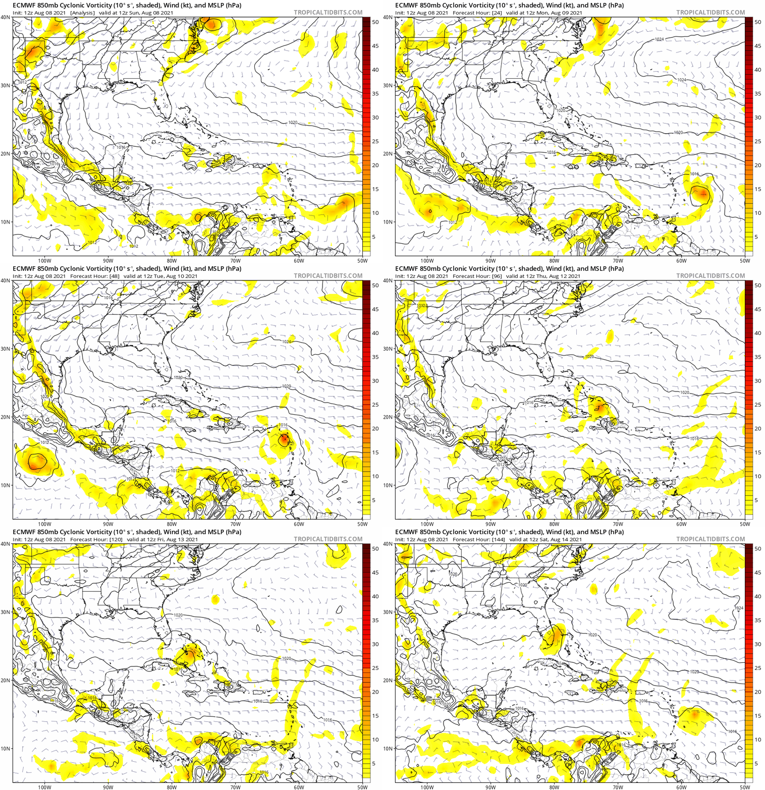
12z EURO...96 Hours... Vorticity strongest so far and likely a TD/TS into PR...

UPDATE... Sorry, into PR, then brushes Hispaniola...
Last edited by Blown Away on Sun Aug 08, 2021 1:24 pm, edited 2 times in total.
1 likes   
Hurricane Eye Experience: David 79, Irene 99, Frances 04, Jeanne 04, Wilma 05... EYE COMING MY WAY IN 2024…
Hurricane Brush Experience: Andrew 92, Erin 95, Floyd 99, Matthew 16, Irma 17, Ian 22, Nicole 22…

User avatar
toad strangler
S2K Supporter
S2K Supporter
Posts: 4171
Joined: Sun Jul 28, 2013 3:09 pm
Location: Earth
Contact:

Re: ATL: 94L - Models

#26 Postby toad strangler » Sun Aug 08, 2021 1:21 pm

Blown Away wrote:https://i.imgur.com/IKMsnUf.gif
12z EURO...96 Hours... Vorticity strongest so far and likely a TD/TS into PR...


That's yesterdays 12z ...

EDIT ... YOU FIXED IT :D
Last edited by toad strangler on Sun Aug 08, 2021 1:24 pm, edited 1 time in total.
1 likes   

User avatar
NDG
S2K Supporter
S2K Supporter
Posts: 14933
Joined: Sun Jul 09, 2006 10:14 pm
Location: Orlando, FL

Re: ATL: 94L - Models

#27 Postby NDG » Sun Aug 08, 2021 1:21 pm

12z Euro, the strongest run so far by the model towards development as it tracks through the Lesser Antilles.

Image
Image
Image
2 likes   

User avatar
kevin
Category 5
Category 5
Posts: 1771
Age: 25
Joined: Wed Aug 28, 2019 4:35 am

Re: ATL: 94L - Models

#28 Postby kevin » Sun Aug 08, 2021 1:28 pm

Euro looks a bit bullish when you take into account how quiet the euro has been lately even with storms that eventually did develop. I'm almost used to euro showing an open wave even when all other models show a TS so the euro showing a TS indicates to me that this has a pretty good development chance.
0 likes   

User avatar
NDG
S2K Supporter
S2K Supporter
Posts: 14933
Joined: Sun Jul 09, 2006 10:14 pm
Location: Orlando, FL

Re: ATL: 94L - Models

#29 Postby NDG » Sun Aug 08, 2021 1:31 pm

12z Euro is still persistent in forecasting the TUTT/ULL to push towards the GOM as 94L heads through The Bahamas.

Image
0 likes   

User avatar
Blown Away
S2K Supporter
S2K Supporter
Posts: 9867
Joined: Wed May 26, 2004 6:17 am

Re: ATL: 94L - Models

#30 Postby Blown Away » Sun Aug 08, 2021 1:32 pm

Image

12z EURO 144 hrs...
Last edited by Blown Away on Sun Aug 08, 2021 1:34 pm, edited 1 time in total.
1 likes   
Hurricane Eye Experience: David 79, Irene 99, Frances 04, Jeanne 04, Wilma 05... EYE COMING MY WAY IN 2024…
Hurricane Brush Experience: Andrew 92, Erin 95, Floyd 99, Matthew 16, Irma 17, Ian 22, Nicole 22…

User avatar
gatorcane
S2K Supporter
S2K Supporter
Posts: 23499
Age: 46
Joined: Sun Mar 13, 2005 3:54 pm
Location: Boca Raton, FL

Re: ATL: 94L - Models

#31 Postby gatorcane » Sun Aug 08, 2021 1:34 pm

12Z Euro through 144 hours. The environment must not be favorable for development over the Bahamas or else the model would show it developing on the approach to Florida:

Image
1 likes   

User avatar
toad strangler
S2K Supporter
S2K Supporter
Posts: 4171
Joined: Sun Jul 28, 2013 3:09 pm
Location: Earth
Contact:

Re: ATL: 94L - Models

#32 Postby toad strangler » Sun Aug 08, 2021 1:36 pm

gatorcane wrote:12Z Euro through 144 hours. The environment must not be favorable for development over the Bahamas or else the model would show it developing on the approach to Florida:

https://i.postimg.cc/ZqJWJM3b/ecmwf-uv850-vort-watl-fh0-144.gif


true, but the Euro didn't develop anything last year until after the fact so how much does that really mean?
7 likes   

User avatar
DestinHurricane
Category 4
Category 4
Posts: 930
Joined: Tue May 01, 2018 8:05 am
Location: Columbus, OH... need to get back in the action

Re: ATL: 94L - Models

#33 Postby DestinHurricane » Sun Aug 08, 2021 1:38 pm

gatorcane wrote:12Z Euro through 144 hours. The environment must not be favorable for development over the Bahamas or else the model would show it developing on the approach to Florida:

https://i.postimg.cc/ZqJWJM3b/ecmwf-uv850-vort-watl-fh0-144.gif


Do you not remember how bad the ECMWF was at intensity and genesis last year? And even this year with Elsa it was bad.
3 likes   
Destin/Santa Rosa Beach, Florida: Ivan 2004, Dennis 2005, Michael 2018, Sally 2020

Fort Lauderdale, Florida Eta 2020, Many future storms!

THE Ohio State University: :cold:

User avatar
NDG
S2K Supporter
S2K Supporter
Posts: 14933
Joined: Sun Jul 09, 2006 10:14 pm
Location: Orlando, FL

Re: ATL: 94L - Models

#34 Postby NDG » Sun Aug 08, 2021 1:38 pm

Something to keep in mind is that the Euro is trending towards stronger ridging off of the Carolinas coast as it tracks near The Bahamas/FL, so an OTS path by 94L is getting out of the question.

Image
0 likes   

User avatar
Category5Kaiju
Category 5
Category 5
Posts: 3402
Age: 22
Joined: Thu Dec 24, 2020 12:45 pm
Location: Seattle

Re: ATL: 94L - Models

#35 Postby Category5Kaiju » Sun Aug 08, 2021 1:40 pm

Here’s the way I see it: if the Euro shows a detectable orange vorticity signature consistently, then you know there’s a pretty high chance of a tropical cyclone of some sort soon. If it shows a robust vorticity signature, then you evacuate. :ggreen:
0 likes   
Unless explicitly stated, all information covered in my posts is based on my opinions and observations. Please refer to a professional meteorologist or an accredited weather research agency otherwise, especially if serious decisions must be made in the event of a potentially life-threatening tropical storm or hurricane.

User avatar
gatorcane
S2K Supporter
S2K Supporter
Posts: 23499
Age: 46
Joined: Sun Mar 13, 2005 3:54 pm
Location: Boca Raton, FL

Re: ATL: 94L - Models

#36 Postby gatorcane » Sun Aug 08, 2021 1:41 pm

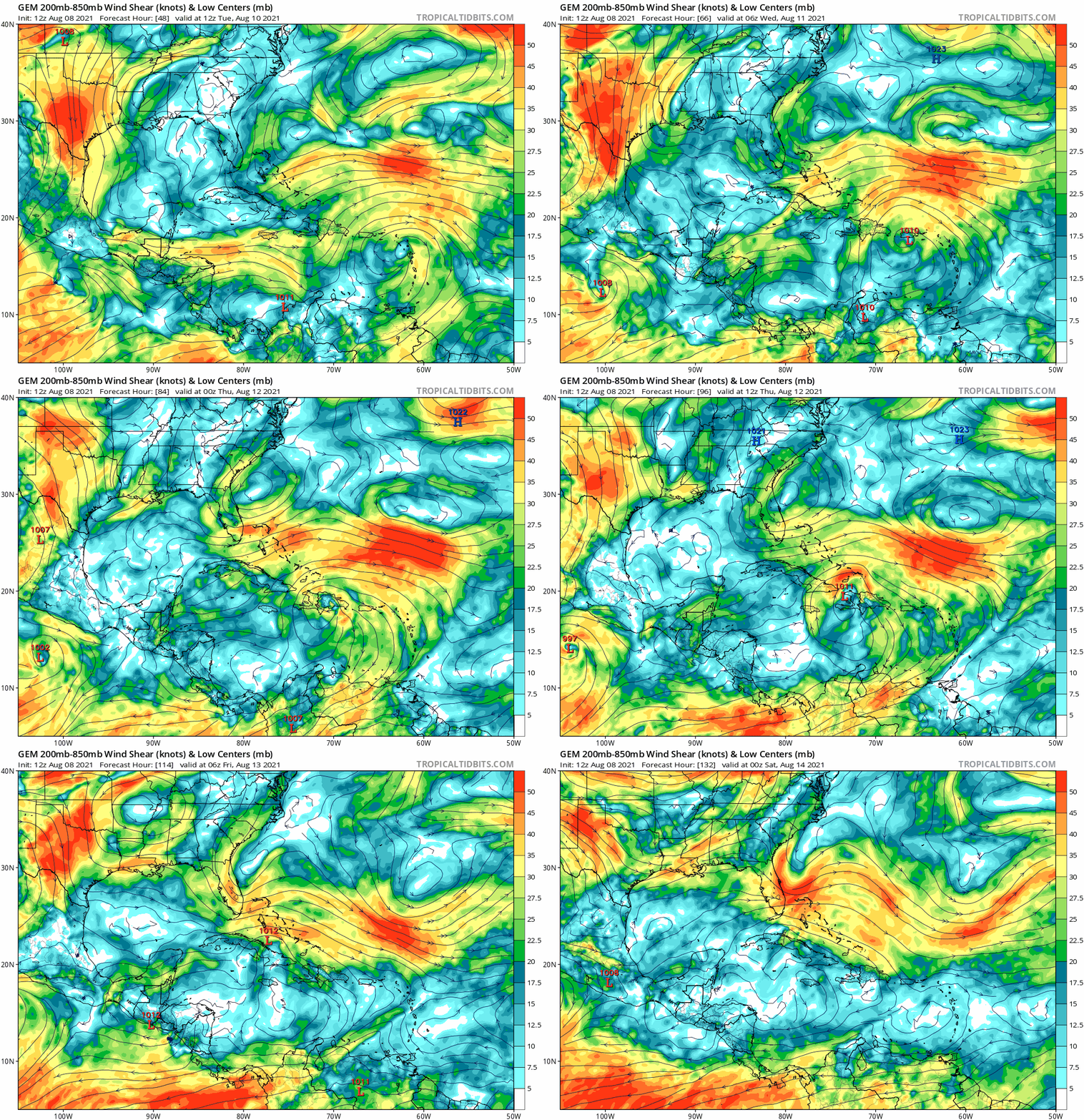
Here is the CMC mode shear forecast, looks similar to the GFS as far as showing a hostile environment by days 4 and 5 across the Bahamas due to the ULL. Euro run with no significant development prior to Florida is certainly more believable:

Image
0 likes   

User avatar
ronjon
Category 5
Category 5
Posts: 4671
Joined: Fri Aug 19, 2005 5:17 pm
Location: Hernando Beach, FL

Re: ATL: 94L - Models

#37 Postby ronjon » Sun Aug 08, 2021 1:47 pm

NDG wrote:Something to keep in mind is that the Euro is trending towards stronger ridging off of the Carolinas coast as it tracks near The Bahamas/FL, so an OTS path by 94L is getting out of the question.


12z CMC brings a moderate TS into Mobile Bay so its apparently seeing some stronger ridging off the SE coast too. Perhaps a trend to watch. 12z ICON also brings the low pressure northward in the eastern GOM.
0 likes   

User avatar
Blown Away
S2K Supporter
S2K Supporter
Posts: 9867
Joined: Wed May 26, 2004 6:17 am

Re: ATL: 94L - Models

#38 Postby Blown Away » Sun Aug 08, 2021 1:49 pm

Image

12z EURO... 192 hrs... Sharp R at SFL and into SC... Vorticity much improved in today's run
0 likes   
Hurricane Eye Experience: David 79, Irene 99, Frances 04, Jeanne 04, Wilma 05... EYE COMING MY WAY IN 2024…
Hurricane Brush Experience: Andrew 92, Erin 95, Floyd 99, Matthew 16, Irma 17, Ian 22, Nicole 22…

User avatar
NDG
S2K Supporter
S2K Supporter
Posts: 14933
Joined: Sun Jul 09, 2006 10:14 pm
Location: Orlando, FL

Re: ATL: 94L - Models

#39 Postby NDG » Sun Aug 08, 2021 1:49 pm

gatorcane wrote:Here is the CMC mode shear forecast, looks similar to the GFS as far as showing a hostile environment by days 4 and 5 across the Bahamas due to the ULL. Euro run with no significant development prior to Florida is certainly more believable:

https://i.postimg.cc/dttvtcNS/gem-shear-watl-fh48-132.gif


But the same Euro shows the TUTT/ULL moving west towards the central GOM out of the way of 94L, it shows not much strengthening near FL because it shows the vorticity making landfall and tracking inland over the Peninsula.
A lot up in the air right now, including that I still don't trust the Euro much past its 5 day range like I used to and that it did horrible with Elsa.

Image
Image
Last edited by NDG on Sun Aug 08, 2021 1:52 pm, edited 1 time in total.
1 likes   

User avatar
AtlanticWind
S2K Supporter
S2K Supporter
Posts: 1805
Age: 65
Joined: Sun Aug 08, 2004 9:57 pm
Location: Plantation,Fla

Re: ATL: 94L - Models

#40 Postby AtlanticWind » Sun Aug 08, 2021 1:51 pm

Sometimes organizing systems take little jumps to the north during the process,
could make a difference for this system for clearing Hispanola to the north later on.
0 likes   


Return to “2021”

Who is online

Users browsing this forum: No registered users and 21 guests