CPAC: LINDA - Post-Tropical

Moderator: S2k Moderators

Message
Author
User avatar
aspen
Category 5
Category 5
Posts: 8059
Joined: Sat Oct 12, 2019 7:10 pm
Location: Connecticut, USA

Re: EPAC: INVEST 93E

#21 Postby aspen » Mon Aug 09, 2021 2:43 pm

Yellow Evan wrote:
* GFS version *
* EAST PACIFIC 2021 SHIPS INTENSITY FORECAST *
* IR SAT DATA AVAILABLE, OHC AVAILABLE *
* INVEST EP932021 08/09/21 18 UTC *

TIME (HR) 0 6 12 18 24 36 48 60 72 84 96 108 120 132 144 156 168
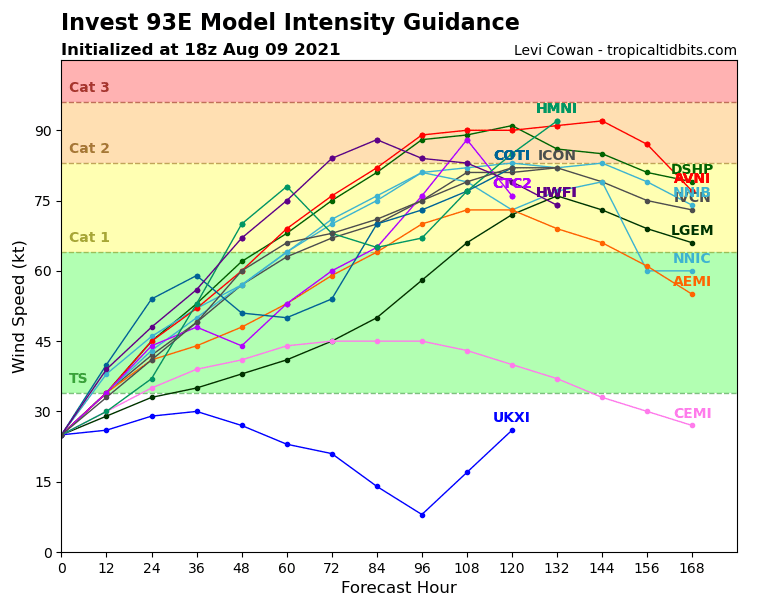
V (KT) NO LAND 25 29 34 40 45 53 62 68 75 81 88 89 91 86 85 81 79
V (KT) LAND 25 29 34 40 45 53 62 68 75 81 88 89 91 86 85 81 79
V (KT) LGEM 25 27 29 31 33 35 38 41 45 50 58 66 72 76 73 69 66
Storm Type TROP TROP TROP TROP TROP TROP TROP TROP TROP TROP TROP TROP TROP TROP TROP TROP TROP

SHEAR (KT) 16 19 22 24 26 25 23 28 17 12 13 17 16 17 8 8 6
SHEAR ADJ (KT) 1 2 2 2 -1 2 0 -1 -2 2 0 0 0 7 7 1 1
SHEAR DIR 343 360 13 15 19 33 29 18 358 17 48 40 50 67 63 56 82
SST (C) 28.8 28.9 29.0 29.1 29.1 29.1 28.8 28.7 28.8 28.9 28.6 28.2 28.3 27.5 26.7 25.7 25.4
POT. INT. (KT) 153 153 154 155 155 155 152 150 151 153 150 146 147 139 131 119 115
200 MB T (C) -53.3 -53.0 -53.5 -53.6 -53.2 -53.4 -53.5 -53.3 -53.2 -53.3 -53.3 -52.9 -52.9 -52.4 -52.1 -51.8 -51.8
200 MB VXT (C) -0.1 -0.1 -0.1 -0.1 -0.2 0.0 0.3 0.3 0.5 0.4 0.6 0.7 0.5 0.6 0.9 1.5 1.3
TH_E DEV (C) 4 4 3 3 5 4 5 5 5 5 5 5 4 3 3 2 2
700-500 MB RH 85 86 85 83 83 84 81 83 82 81 82 79 75 69 66 62 60
MODEL VTX (KT) 8 9 11 13 15 15 18 20 23 26 32 33 36 35 38 38 39
850 MB ENV VOR -47 -39 -60 -61 -58 -50 -33 -15 -11 -6 12 21 35 57 82 112 125
200 MB DIV 164 189 164 139 133 122 119 118 122 119 90 73 53 46 41 5 5
700-850 TADV -5 -7 -7 -7 -7 -7 -5 -11 -9 -18 -8 -3 -1 0 1 0 -2
LAND (KM) 448 456 466 443 421 406 443 467 516 584 604 599 675 785 915 1044 1159
LAT (DEG N) 12.2 xx.x xx.x xx.x xx.x xx.x xx.x xx.x xx.x xx.x xx.x xx.x xx.x xx.x xx.x xx.x xx.x
LONG(DEG W) 99.4 xxx.x xxx.x xxx.x xxx.x xxx.x xxx.x xxx.x xxx.x xxx.x xxx.x xxx.x xxx.x xxx.x xxx.x xxx.x xxx.x
STM SPEED (KT) 10 8 9 9 8 8 8 7 7 9 9 8 9 11 10 8 6
HEAT CONTENT 16 19 25 28 22 18 16 15 15 13 11 8 8 4 1 0 0

FORECAST TRACK FROM OFPI INITIAL HEADING/SPEED (DEG/KT):290/ 13 CX,CY: -11/ 4
T-12 MAX WIND: 20 PRESSURE OF STEERING LEVEL (MB): 620 (MEAN=587)
GOES IR BRIGHTNESS TEMP. STD DEV. 50-200 KM RAD: 17.1 (MEAN=14.5)
% GOES IR PIXELS WITH T < -20 C 50-200 KM RAD: 92.0 (MEAN=65.0)
PRELIM RI PROB (DV .GE. 35 KT IN 36 HR): 32.5

INDIVIDUAL CONTRIBUTIONS TO INTENSITY CHANGE
6 12 18 24 36 48 60 72 84 96 108 120 132 144 156 168
------------------------------------------------------------------------------
SAMPLE MEAN CHANGE 0. 0. 1. 1. 1. 2. 1. 1. 0. -0. -1. -2. -2. -3. -4. -4.
SST POTENTIAL -0. -0. -0. 1. 5. 12. 19. 25. 29. 32. 35. 37. 39. 40. 40. 41.
VERTICAL SHEAR MAG 1. 1. 1. 2. 1. -3. -8. -12. -14. -15. -15. -14. -13. -12. -12. -12.
VERTICAL SHEAR ADJ -0. -0. -0. -0. -1. -1. -0. -0. -0. -0. -0. 0. -0. -0. -0. -0.
VERTICAL SHEAR DIR -0. 0. 0. 1. 1. 2. 3. 3. 3. 3. 2. 2. 2. 1. 1. 1.
PERSISTENCE 1. 1. 1. 2. 1. 1. 1. 1. 1. 1. 1. 1. 1. 1. 1. 1.
200/250 MB TEMP. 0. 0. -0. -0. -1. -1. -2. -3. -3. -2. -2. -1. 1. 2. 4. 5.
THETA_E EXCESS -0. -1. -1. -1. -2. -3. -3. -3. -4. -4. -4. -4. -5. -5. -6. -8.
700-500 MB RH 0. 0. 1. 1. 2. 2. 2. 2. 2. 2. 3. 3. 3. 4. 5. 7.
MODEL VTX TENDENCY 0. 1. 3. 5. 5. 9. 14. 20. 25. 32. 32. 33. 29. 29. 26. 24.
850 MB ENV VORTICITY -0. -0. -0. -0. -0. 0. 1. 1. 1. 1. 2. 2. 2. 1. 1. 1.
200 MB DIVERGENCE 1. 1. 2. 2. 3. 4. 7. 9. 10. 10. 9. 7. 4. 1. -1. -2.
850-700 T ADVEC 0. 0. 0. 0. 0. -0. -0. -0. -0. -0. -1. -1. -1. -1. -1. -2.
ZONAL STORM MOTION 0. 0. 1. 1. 1. 2. 2. 2. 1. 1. 1. 1. 1. 1. 0. -0.
STEERING LEVEL PRES 0. 0. 0. 0. 0. 1. 1. 1. 1. 1. 1. 1. 1. 1. 1. 0.
DAYS FROM CLIM. PEAK 0. 0. 0. 0. 0. 0. 0. 1. 1. 1. 1. 2. 2. 2. 2. 3.
GOES PREDICTORS 1. 2. 2. 2. 2. 2. 2. 2. 2. 1. 2. 2. 2. 1. 1. 0.
OCEAN HEAT CONTENT -0. 0. 0. 0. 0. 0. 0. 0. -0. -0. 0. 0. 0. 1. 1. 2.
RI POTENTIAL 1. 2. 3. 5. 7. 7. 4. 1. -1. -2. -3. -3. -3. -3. -3. -3.
------------------------------------------------------------------------------
TOTAL CHANGE 4. 9. 15. 20. 28. 37. 43. 50. 56. 63. 64. 66. 61. 60. 56. 54.

CURRENT MAX WIND (KT): 25. LAT, LON: 12.2 99.4

** 2021 E. Pacific RI INDEX EP932021 INVEST 08/09/21 18 UTC **
(SHIPS-RII PREDICTOR TABLE for 30 KT OR MORE MAXIMUM WIND INCREASE IN NEXT 24-h)

Predictor Value RI Predictor Range Scaled Value(0-1) % Contribution
POT = MPI-VMAX (KT) : 129.1 40.5 to 149.3 0.81 999.0
12 HR PERSISTENCE (KT) : 5.0 -22.0 to 44.0 0.41 999.0
D200 (10**7s-1) : 157.8 -33.0 to 159.5 0.99 999.0
850-200 MB SHEAR (KT) : 21.6 19.6 to 1.3 0.00 0.0
MAXIMUM WIND (KT) : 25.0 22.5 to 132.0 0.07 999.0
STD DEV OF IR BR TEMP : 17.1 37.8 to 2.1 0.58 999.0
BL DRY-AIR FLUX (W/M2) : 3.6 800.8 to -82.5 0.90 999.0
HEAT CONTENT (KJ/CM2) : 22.0 2.7 to 106.7 0.19 999.0
%area of TPW <45 mm upshear : 0.0 56.6 to 0.0 1.00 999.0
2nd PC OF IR BR TEMP : -0.2 2.2 to -2.3 0.53 999.0

SHIPS Prob RI for 20kt/ 12hr RI threshold= 0% is 0.0 times climatological mean ( 6.3%)
SHIPS Prob RI for 25kt/ 24hr RI threshold= 21% is 1.7 times climatological mean (12.5%)
SHIPS Prob RI for 30kt/ 24hr RI threshold= 0% is 0.0 times climatological mean ( 8.6%)
SHIPS Prob RI for 35kt/ 24hr RI threshold= 0% is 0.0 times climatological mean ( 6.2%)
SHIPS Prob RI for 40kt/ 24hr RI threshold= 0% is 0.0 times climatological mean ( 4.2%)
SHIPS Prob RI for 45kt/ 36hr RI threshold= 0% is 0.0 times climatological mean ( 6.7%)
SHIPS Prob RI for 55kt/ 48hr RI threshold= 0% is 0.0 times climatological mean ( 5.9%)
SHIPS Prob RI for 65kt/ 72hr RI threshold= 0% is 0.0 times climatological mean ( 4.7%)

Matrix of RI probabilities
------------------------------------------------------------------------------
RI (kt / h) | 20/12 | 25/24 | 30/24 | 35/24 | 40/24 | 45/36 | 55/48 |65/72
------------------------------------------------------------------------------
SHIPS-RII: 0.0% 20.6% 0.0% 0.0% 0.0% 0.0% 0.0% 0.0%
Logistic: 0.8% 5.2% 1.5% 0.8% 0.2% 3.5% 28.0% 25.7%
Bayesian: 0.0% 1.6% 0.0% 0.0% 0.0% 0.0% 0.0% 0.5%
Consensus: 0.3% 9.1% 0.5% 0.3% 0.1% 1.2% 9.3% 8.7%
DTOPS: 1.0% 25.0% 13.0% 7.0% 6.0% 6.0% 17.0% 33.0%

## ANNULAR HURRICANE INDEX (AHI) EP932021 INVEST 08/09/21 18 UTC ##
## STORM NOT ANNULAR, SCREENING STEP FAILED, NPASS=6 NFAIL=1 ##
## AHI= 0 (AHI OF 100 IS BEST FIT TO ANN. STRUC., 1 IS MARGINAL, 0 IS NOT ANNULAR) ##

I don’t know why SHIPS is making this a Category 2 despite 20-25 kt of shear. Odds are it’ll be yet another failure storm line Guillermo and Kevin.
1 likes   
Irene '11 Sandy '12 Hermine '16 5/15/2018 Derecho Fay '20 Isaias '20 Elsa '21 Henri '21 Ida '21

I am only a meteorology enthusiast who knows a decent amount about tropical cyclones. Look to the professional mets, the NHC, or your local weather office for the best information.

User avatar
Yellow Evan
Professional-Met
Professional-Met
Posts: 15959
Age: 25
Joined: Fri Jul 15, 2011 12:48 pm
Location: Henderson, Nevada/Honolulu, HI
Contact:

Re: EPAC: INVEST 93E

#22 Postby Yellow Evan » Mon Aug 09, 2021 2:47 pm

Image

12z ECMWF seems to have a southerly dip but has this moving more north in the short term meaning less time over warm waters.
0 likes   

User avatar
cycloneye
Admin
Admin
Posts: 139483
Age: 67
Joined: Thu Oct 10, 2002 10:54 am
Location: San Juan, Puerto Rico

Re: EPAC: INVEST 93E

#23 Postby cycloneye » Mon Aug 09, 2021 6:47 pm

Satellite data indicate that a large low pressure system located
about 300 miles south of Acapulco, Mexico, is becoming better
defined. In addition, showers and thunderstorms are beginning to
show signs of organization, and environmental conditions are
conducive for further development. A tropical depression is likely
to form later tonight or early Tuesday while the low moves
west-northwestward to westward at 10 to 15 mph through midweek,
parallel to and well offshore the coasts of southern and
southwestern Mexico. Additional information on this system can be
found in high seas forecasts issued by the NOAA National Weather
Service.
* Formation chance through 48 hours...high...90 percent.
* Formation chance through 5 days...high...90 percent.
0 likes   
Visit the Caribbean-Central America Weather Thread where you can find at first post web cams,radars
and observations from Caribbean basin members Click Here

User avatar
Kingarabian
S2K Supporter
S2K Supporter
Posts: 15454
Joined: Sat Aug 08, 2009 3:06 am
Location: Honolulu, Hawaii

Re: EPAC: INVEST 93E

#24 Postby Kingarabian » Mon Aug 09, 2021 6:50 pm

This 12z track is a bit better in regards to seeing a long strong tracker that generates a good amount of ACE, but its super risky if it gets even closer to Mexico. Could face the same fate as Kevin.

Image
0 likes   
RIP Kobe Bryant

AlphaToOmega
Category 5
Category 5
Posts: 1448
Joined: Sat Jun 26, 2021 10:51 am
Location: Somewhere in Massachusetts

Re: EPAC: INVEST 93E

#25 Postby AlphaToOmega » Mon Aug 09, 2021 7:06 pm

Most models take this to hurricane status.
Image
0 likes   

User avatar
Yellow Evan
Professional-Met
Professional-Met
Posts: 15959
Age: 25
Joined: Fri Jul 15, 2011 12:48 pm
Location: Henderson, Nevada/Honolulu, HI
Contact:

Re: EPAC: INVEST 93E

#26 Postby Yellow Evan » Mon Aug 09, 2021 7:11 pm

The models are strengthening this short term in spite of similar or even greater shear compared to Kevin so take them with a grain of salt. Granted it may have a more divergent setup to fight off the shear.
1 likes   

User avatar
Kingarabian
S2K Supporter
S2K Supporter
Posts: 15454
Joined: Sat Aug 08, 2009 3:06 am
Location: Honolulu, Hawaii

Re: EPAC: INVEST 93E

#27 Postby Kingarabian » Mon Aug 09, 2021 7:14 pm

AlphaToOmega wrote:Most models take this to hurricane status.
https://i.postimg.cc/63YgkC5M/93-E-intensity-latest.png

Yeah the models can't see how hostile the area near 15N/110W truly is. Maybe further west it'll fair better. But by that time it might already be near cool waters.
0 likes   
RIP Kobe Bryant

Sciencerocks
Category 5
Category 5
Posts: 7293
Age: 38
Joined: Thu Jul 06, 2017 1:51 am

Re: EPAC: INVEST 93E

#28 Postby Sciencerocks » Mon Aug 09, 2021 9:01 pm

Image
0 likes   

User avatar
Yellow Evan
Professional-Met
Professional-Met
Posts: 15959
Age: 25
Joined: Fri Jul 15, 2011 12:48 pm
Location: Henderson, Nevada/Honolulu, HI
Contact:

Re: EPAC: INVEST 93E

#29 Postby Yellow Evan » Mon Aug 09, 2021 9:49 pm

* GFS version *
* EAST PACIFIC 2021 SHIPS INTENSITY FORECAST *
* IR SAT DATA AVAILABLE, OHC AVAILABLE *
* INVEST EP932021 08/10/21 00 UTC *

TIME (HR) 0 6 12 18 24 36 48 60 72 84 96 108 120 132 144 156 168
V (KT) NO LAND 30 34 40 46 52 61 67 71 78 81 83 84 81 78 74 69 64
V (KT) LAND 30 34 40 46 52 61 67 71 78 81 83 84 81 78 74 69 64
V (KT) LGEM 30 31 32 34 35 37 40 44 49 56 63 69 72 69 64 57 51
Storm Type TROP TROP TROP TROP TROP TROP TROP TROP TROP TROP TROP TROP TROP TROP TROP TROP TROP

SHEAR (KT) 17 21 24 29 25 26 23 20 14 18 15 14 19 15 10 10 2
SHEAR ADJ (KT) 4 3 1 -3 0 2 1 1 1 -1 0 -2 0 5 7 1 0
SHEAR DIR 1 6 9 20 20 37 19 6 353 21 36 57 76 73 76 81 154
SST (C) 28.9 29.0 29.1 29.1 29.1 29.0 28.7 28.7 28.9 28.7 28.4 28.0 27.3 26.5 26.1 25.3 24.1
POT. INT. (KT) 154 154 155 155 155 154 150 151 153 151 148 145 137 128 124 117 105
200 MB T (C) -53.1 -53.5 -53.6 -53.3 -52.8 -53.9 -53.1 -53.6 -53.0 -53.6 -52.9 -53.0 -52.4 -52.4 -52.0 -52.4 -51.8
200 MB VXT (C) -0.1 0.0 -0.1 -0.1 -0.1 0.1 0.3 0.3 0.4 0.6 0.8 0.6 0.6 0.8 0.8 1.3 0.8
TH_E DEV (C) 4 4 3 5 6 4 6 5 6 5 5 4 3 2 2 2 2
700-500 MB RH 86 85 84 82 83 84 80 83 80 82 81 77 73 68 63 60 56
MODEL VTX (KT) 9 10 13 14 16 17 18 21 25 28 31 33 34 35 35 34 32
850 MB ENV VOR -42 -58 -68 -59 -46 -49 -16 -4 6 7 15 26 53 66 84 113 118
200 MB DIV 180 161 132 139 149 120 109 97 123 91 90 57 20 33 10 10 29
700-850 TADV -5 -7 -7 -7 -8 -7 -7 -9 -19 -19 -3 0 0 2 1 0 -1
LAND (KM) 449 435 420 408 402 424 466 495 551 617 584 645 749 876 1016 1191 1374
LAT (DEG N) 12.6 xx.x xx.x xx.x xx.x xx.x xx.x xx.x xx.x xx.x xx.x xx.x xx.x xx.x xx.x xx.x xx.x
LONG(DEG W) 100.4 xxx.x xxx.x xxx.x xxx.x xxx.x xxx.x xxx.x xxx.x xxx.x xxx.x xxx.x xxx.x xxx.x xxx.x xxx.x xxx.x
STM SPEED (KT) 10 8 8 7 8 8 7 8 9 9 9 11 10 9 9 12 12
HEAT CONTENT 21 24 26 21 18 18 15 15 14 11 9 6 3 1 0 0 0

FORECAST TRACK FROM OFPI INITIAL HEADING/SPEED (DEG/KT):290/ 11 CX,CY: -9/ 4
T-12 MAX WIND: 30 PRESSURE OF STEERING LEVEL (MB): 595 (MEAN=587)
GOES IR BRIGHTNESS TEMP. STD DEV. 50-200 KM RAD: 9.1 (MEAN=14.5)
% GOES IR PIXELS WITH T < -20 C 50-200 KM RAD: 99.0 (MEAN=65.0)
PRELIM RI PROB (DV .GE. 35 KT IN 36 HR): 48.2

INDIVIDUAL CONTRIBUTIONS TO INTENSITY CHANGE
6 12 18 24 36 48 60 72 84 96 108 120 132 144 156 168
------------------------------------------------------------------------------
SAMPLE MEAN CHANGE 0. 0. 1. 1. 1. 2. 1. 1. 0. -0. -1. -2. -2. -3. -4. -4.
SST POTENTIAL 0. 0. 0. 2. 6. 11. 17. 23. 26. 29. 31. 33. 34. 34. 34. 34.
VERTICAL SHEAR MAG 0. 1. 1. 0. -1. -4. -8. -11. -13. -14. -14. -14. -13. -12. -13. -12.
VERTICAL SHEAR ADJ -0. -0. -0. -0. -1. -1. -1. -0. -0. -0. -0. -0. -0. -0. -0. -0.
VERTICAL SHEAR DIR 0. 0. 1. 1. 2. 3. 3. 3. 2. 2. 2. 2. 1. 1. 0. 0.
PERSISTENCE -0. -0. -0. -1. -1. -1. -0. -0. -0. -0. -0. -0. -0. -0. -0. -0.
200/250 MB TEMP. 0. 0. -0. -0. -1. -1. -2. -2. -3. -2. -1. -0. 1. 3. 5. 5.
THETA_E EXCESS -0. -1. -1. -1. -2. -2. -3. -3. -3. -4. -4. -4. -5. -6. -7. -9.
700-500 MB RH 0. 0. 1. 1. 2. 2. 2. 2. 2. 2. 3. 3. 3. 4. 5. 6.
MODEL VTX TENDENCY 0. 2. 3. 5. 6. 8. 14. 21. 26. 29. 30. 29. 27. 25. 21. 17.
850 MB ENV VORTICITY -0. -0. -0. -0. -0. 0. 1. 1. 1. 1. 1. 1. 1. 1. 1. 0.
200 MB DIVERGENCE 1. 1. 2. 2. 3. 4. 6. 8. 9. 9. 8. 6. 4. 1. -0. -2.
850-700 T ADVEC 0. 0. 0. 0. 0. -0. -0. -0. -0. -0. -1. -1. -1. -1. -2. -2.
ZONAL STORM MOTION 0. 0. 0. 0. 1. 1. 1. 1. 1. 1. 1. 1. 0. 0. 0. -0.
STEERING LEVEL PRES 0. 0. 0. 0. 0. 0. 0. 0. 0. 0. 0. 0. 0. 0. 0. 0.
DAYS FROM CLIM. PEAK 0. 0. 0. 0. 0. 0. 0. 1. 1. 1. 2. 2. 2. 2. 3. 3.
GOES PREDICTORS 2. 3. 3. 4. 3. 3. 3. 3. 2. 2. 3. 3. 3. 2. 1. 0.
OCEAN HEAT CONTENT 0. 0. 0. 0. 0. 0. 0. -0. -0. -0. 0. 0. 0. 1. 2. 3.
RI POTENTIAL 1. 3. 6. 8. 13. 12. 7. 2. -2. -4. -6. -7. -7. -7. -7. -7.
------------------------------------------------------------------------------
TOTAL CHANGE 4. 10. 16. 22. 31. 37. 41. 48. 51. 53. 54. 51. 48. 45. 39. 34.

CURRENT MAX WIND (KT): 30. LAT, LON: 12.6 100.4

** 2021 E. Pacific RI INDEX EP932021 INVEST 08/10/21 00 UTC **
(SHIPS-RII PREDICTOR TABLE for 30 KT OR MORE MAXIMUM WIND INCREASE IN NEXT 24-h)

Predictor Value RI Predictor Range Scaled Value(0-1) % Contribution
POT = MPI-VMAX (KT) : 124.4 40.5 to 149.3 0.77 999.0
12 HR PERSISTENCE (KT) : 0.0 -22.0 to 44.0 0.33 999.0
D200 (10**7s-1) : 152.2 -33.0 to 159.5 0.96 999.0
850-200 MB SHEAR (KT) : 23.4 19.6 to 1.3 0.00 0.0
MAXIMUM WIND (KT) : 30.0 22.5 to 132.0 0.21 999.0
STD DEV OF IR BR TEMP : 9.1 37.8 to 2.1 0.80 999.0
BL DRY-AIR FLUX (W/M2) : 11.0 800.8 to -82.5 0.89 999.0
HEAT CONTENT (KJ/CM2) : 22.0 2.7 to 106.7 0.19 999.0
%area of TPW <45 mm upshear : 0.0 56.6 to 0.0 1.00 999.0
2nd PC OF IR BR TEMP : 0.2 2.2 to -2.3 0.44 999.0

SHIPS Prob RI for 20kt/ 12hr RI threshold= 0% is 0.0 times climatological mean ( 6.3%)
SHIPS Prob RI for 25kt/ 24hr RI threshold= 22% is 1.8 times climatological mean (12.5%)
SHIPS Prob RI for 30kt/ 24hr RI threshold= 0% is 0.0 times climatological mean ( 8.6%)
SHIPS Prob RI for 35kt/ 24hr RI threshold= 0% is 0.0 times climatological mean ( 6.2%)
SHIPS Prob RI for 40kt/ 24hr RI threshold= 0% is 0.0 times climatological mean ( 4.2%)
SHIPS Prob RI for 45kt/ 36hr RI threshold= 0% is 0.0 times climatological mean ( 6.7%)
SHIPS Prob RI for 55kt/ 48hr RI threshold= 0% is 0.0 times climatological mean ( 5.9%)
SHIPS Prob RI for 65kt/ 72hr RI threshold= 0% is 0.0 times climatological mean ( 4.7%)

Matrix of RI probabilities
------------------------------------------------------------------------------
RI (kt / h) | 20/12 | 25/24 | 30/24 | 35/24 | 40/24 | 45/36 | 55/48 |65/72
------------------------------------------------------------------------------
SHIPS-RII: 0.0% 21.9% 0.0% 0.0% 0.0% 0.0% 0.0% 0.0%
Logistic: 2.4% 13.2% 3.6% 2.2% 0.9% 6.0% 11.3% 12.9%
Bayesian: 0.2% 1.5% 0.0% 0.0% 0.0% 0.0% 0.0% 0.0%
Consensus: 0.9% 12.2% 1.2% 0.7% 0.3% 2.0% 3.8% 4.3%
DTOPS: 3.0% 34.0% 9.0% 5.0% 3.0% 14.0% 28.0% 21.0%

## ANNULAR HURRICANE INDEX (AHI) EP932021 INVEST 08/10/21 00 UTC ##
## STORM NOT ANNULAR, SCREENING STEP FAILED, NPASS=4 NFAIL=3 ##
## AHI= 0 (AHI OF 100 IS BEST FIT TO ANN. STRUC., 1 IS MARGINAL, 0 IS NOT ANNULAR) ##
0 likes   

Hurricane Mike
Category 2
Category 2
Posts: 562
Joined: Tue Apr 10, 2018 7:44 am

Re: EPAC: INVEST 93E

#30 Postby Hurricane Mike » Mon Aug 09, 2021 10:37 pm

Good thing this will move away, I'm guessing it becomes a potent hurricane.
0 likes   

User avatar
ElectricStorm
Category 5
Category 5
Posts: 4617
Age: 23
Joined: Tue Aug 13, 2019 11:23 pm
Location: Skiatook, OK / Norman, OK

Re: EPAC: INVEST 93E

#31 Postby ElectricStorm » Tue Aug 10, 2021 12:39 am

Looks like we're about to get 12E at 5am EDT

1. Recent satellite-derived wind data indicate that a large low
pressure system located about 300 miles south of Acapulco, Mexico,
has developed a well-defined center and is producing 30 to 35-mph
winds. Additionally, associated shower and thunderstorm activity is
showing increased signs of organization. Therefore, advisories will
likely be initiated on a tropical depression early this morning.
The low is forecast to move west-northwestward to westward at 10 to
15 mph through midweek, parallel to and well offshore of the coast
of southwestern Mexico.
* Formation chance through 48 hours...high...90 percent.
* Formation chance through 5 days...high...90 percent.
0 likes   
I am in no way a professional. Take what I say with a grain of salt as I could be totally wrong. Please refer to the NHC, NWS, or SPC for official information.

Boomer Sooner!

User avatar
Yellow Evan
Professional-Met
Professional-Met
Posts: 15959
Age: 25
Joined: Fri Jul 15, 2011 12:48 pm
Location: Henderson, Nevada/Honolulu, HI
Contact:

Re: EPAC: INVEST 93E

#32 Postby Yellow Evan » Tue Aug 10, 2021 12:42 am

Yea it’s definitely worthy of classification but also badly sheared. 0z GFS showed less shear than the 18z run in the short term however.
0 likes   

User avatar
Yellow Evan
Professional-Met
Professional-Met
Posts: 15959
Age: 25
Joined: Fri Jul 15, 2011 12:48 pm
Location: Henderson, Nevada/Honolulu, HI
Contact:

Re: EPAC: INVEST 93E

#33 Postby Yellow Evan » Tue Aug 10, 2021 12:46 am

Image

0z GFS slowly caving to the ECMWF in terms of southerly dive that could keep this over warmer waters for a while before recurvature - that phase of the track would be more interesting in a strong +PMM year where we could get a legit hurricane up to around 20N or so.
0 likes   

User avatar
Yellow Evan
Professional-Met
Professional-Met
Posts: 15959
Age: 25
Joined: Fri Jul 15, 2011 12:48 pm
Location: Henderson, Nevada/Honolulu, HI
Contact:

Re: EPAC: INVEST 93E

#34 Postby Yellow Evan » Tue Aug 10, 2021 1:06 am

Image
0 likes   

User avatar
cycloneye
Admin
Admin
Posts: 139483
Age: 67
Joined: Thu Oct 10, 2002 10:54 am
Location: San Juan, Puerto Rico

Re: EPAC: TWELVE-E - Tropical Depression

#35 Postby cycloneye » Tue Aug 10, 2021 4:56 am

Tropical Depression Twelve-E Discussion Number 1
NWS National Hurricane Center Miami FL EP122021
400 AM CDT Tue Aug 10 2021

Over the past several hours, showers and thunderstorms have showed
increased signs of organization in association with an area of low
pressure located a few hundred miles south of Acapulco, Mexico. An
ASCAT-B pass around 0330 UTC revealed that the low has developed a
well-defined center and is producing 25 to 30-kt winds, with some
higher wind vectors flagged as rain contaminated within the deep
convection occurring to the south and west of the center. The system
has become sufficiently organized to be classified as a tropical
depression, and its initial intensity is set at 30 kt for this
advisory.

The estimated motion of the depression is west-northwest, or
290/7 kt. The system is expected to generally move
west-northwestward to westward over the next several days, as it is
steered by a ridge to its north and northeast. This track is roughly
parallel to, but well offshore of, the southwestern coast of
Mexico. The track guidance is in reasonably good agreement, and the
official NHC forecast lies near the center of the guidance envelope.

The depression is located in a moist, unstable environment with
ample oceanic heat content to fuel strengthening during the next few
days. However, moderate to strong northerly vertical wind shear will
likely prevent rapid intensification of this system in the short
term. Nonetheless, the intensity guidance unanimously supports
strengthening, and this system is likely to become a tropical storm
later today. Continued strengthening is forecast through the rest of
the week and into the weekend, and the cyclone could reach hurricane
strength by Thursday. The official NHC intensity forecast generally
follows the IVCN consensus aid and shows the system's intensity
peaking on days 4 and 5, when the wind shear is forecast to
diminish while the cyclone remains over warm SSTs.


FORECAST POSITIONS AND MAX WINDS

INIT 10/0900Z 13.0N 100.8W 30 KT 35 MPH
12H 10/1800Z 13.7N 102.0W 40 KT 45 MPH
24H 11/0600Z 14.3N 103.6W 45 KT 50 MPH
36H 11/1800Z 14.5N 105.3W 50 KT 60 MPH
48H 12/0600Z 14.7N 106.5W 60 KT 70 MPH
60H 12/1800Z 15.3N 107.9W 65 KT 75 MPH
72H 13/0600Z 16.3N 109.4W 70 KT 80 MPH
96H 14/0600Z 18.2N 113.3W 80 KT 90 MPH
120H 15/0600Z 19.0N 117.5W 80 KT 90 MPH

$$
Forecaster Reinhart/Pasch
0 likes   
Visit the Caribbean-Central America Weather Thread where you can find at first post web cams,radars
and observations from Caribbean basin members Click Here

User avatar
aspen
Category 5
Category 5
Posts: 8059
Joined: Sat Oct 12, 2019 7:10 pm
Location: Connecticut, USA

Re: EPAC: TWELVE-E - Tropical Depression

#36 Postby aspen » Tue Aug 10, 2021 7:05 am

If Linda wants to avoid the same fate as Kevin and not be another massive model bust, it will need to start RI right now, before it runs into the wall of shear that doomed Kevin. Still highly unlikely we get anything close to those 950s and 940s GFS runs, given how badly the model failed with both Kevin and Guillermo.
1 likes   
Irene '11 Sandy '12 Hermine '16 5/15/2018 Derecho Fay '20 Isaias '20 Elsa '21 Henri '21 Ida '21

I am only a meteorology enthusiast who knows a decent amount about tropical cyclones. Look to the professional mets, the NHC, or your local weather office for the best information.

User avatar
cycloneye
Admin
Admin
Posts: 139483
Age: 67
Joined: Thu Oct 10, 2002 10:54 am
Location: San Juan, Puerto Rico

Re: EPAC: TWELVE-E - Tropical Depression

#37 Postby cycloneye » Tue Aug 10, 2021 9:43 am

Tropical Depression Twelve-E Discussion Number 2
NWS National Hurricane Center Miami FL EP122021
1000 AM CDT Tue Aug 10 2021

The depression is slowly getting better organized, with deep
convection becoming a bit more concentrated. However, the system
appears to be undergoing moderate to strong northerly shear, which
is keeping this convection mainly confined to the southern portion
of the cyclone's circulation. The initial intensity is being held
at 30 kt, which is in agreement with the latest Dvorak T-number
from TAFB.

The estimated motion of the depression is 295/9 kt. The cyclone is
expected to turn westward by Wednesday as a ridge builds to its
north, and then resume a west-northwestward motion by late this week
as it begins to move along the southwestern periphery of this ridge.
This track is roughly parallel to, but well offshore of, the
southwestern coast of Mexico over the next couple of days.
Thereafter, the depression is forecast to move away from the coast
of Mexico. The latest NHC forecast track is little changed from the
previous one, and lies near the consensus guidance tracks.

The depression is within a moist, unstable environment with ample
oceanic heat content to fuel strengthening during the next few days.
However, ongoing northerly vertical wind shear will likely slow the
rate of intensification of this system over the next day or so. The
shear is forecast to diminish somewhat after 24 h, which should
allow for a faster rate of intensification for a couple of days.
Late in the forecast period, the cyclone is expected to reach cooler
waters, which should begin to weaken the system. The official NHC
intensity forecast is near the IVCN consensus through 60 h, and is
then near the HFIP corrected consensus HCCA thereafter. Based on
this forecast, the depression should become a tropical storm by
tonight and a hurricane on Thursday.


FORECAST POSITIONS AND MAX WINDS

INIT 10/1500Z 13.4N 101.5W 30 KT 35 MPH
12H 11/0000Z 14.0N 102.8W 35 KT 40 MPH
24H 11/1200Z 14.3N 104.6W 45 KT 50 MPH
36H 12/0000Z 14.5N 105.8W 55 KT 65 MPH
48H 12/1200Z 14.9N 107.1W 65 KT 75 MPH
60H 13/0000Z 15.8N 108.6W 75 KT 85 MPH
72H 13/1200Z 16.8N 110.4W 80 KT 90 MPH
96H 14/1200Z 18.4N 114.5W 80 KT 90 MPH
120H 15/1200Z 19.2N 118.3W 75 KT 85 MPH

$$
Forecaster Latto
0 likes   
Visit the Caribbean-Central America Weather Thread where you can find at first post web cams,radars
and observations from Caribbean basin members Click Here

User avatar
Yellow Evan
Professional-Met
Professional-Met
Posts: 15959
Age: 25
Joined: Fri Jul 15, 2011 12:48 pm
Location: Henderson, Nevada/Honolulu, HI
Contact:

Re: EPAC: TWELVE-E - Tropical Depression

#38 Postby Yellow Evan » Tue Aug 10, 2021 12:31 pm

Image

12z GFS continues to shift south, down to 953 mbars and now relaxes the shear in about two days.
0 likes   

User avatar
Yellow Evan
Professional-Met
Professional-Met
Posts: 15959
Age: 25
Joined: Fri Jul 15, 2011 12:48 pm
Location: Henderson, Nevada/Honolulu, HI
Contact:

Re: EPAC: TWELVE-E - Tropical Depression

#39 Postby Yellow Evan » Tue Aug 10, 2021 12:37 pm

Image

0z ECMWF.
0 likes   

User avatar
Yellow Evan
Professional-Met
Professional-Met
Posts: 15959
Age: 25
Joined: Fri Jul 15, 2011 12:48 pm
Location: Henderson, Nevada/Honolulu, HI
Contact:

Re: EPAC: TWELVE-E - Tropical Depression

#40 Postby Yellow Evan » Tue Aug 10, 2021 1:17 pm

TXPZ23 KNES 101805
TCSENP

A. 12E (NONAME)

B. 10/1730Z

C. 13.6N

D. 102.0W

E. THREE/GOES-E

F. T2.0/2.0

G. IR/EIR/VIS/SSMIS

H. REMARKS...5/10 BANDING AROUND LLCC YIELDS DT OF 2.5. MET IS 1.5 AND
PT IS 2.0. FT IS BASED ON PT DUE TO BANDING NOT BEING CLEAR-CUT.

I. ADDL POSITIONS

10/1317Z 13.7N 101.9W SSMIS


...MLEVINE
0 likes   


Return to “2021”

Who is online

Users browsing this forum: No registered users and 6 guests