
ATL: MINDY - Post-Tropical - Discussion
Moderator: S2k Moderators
-
Sciencerocks
- Category 5

- Posts: 7294
- Age: 38
- Joined: Thu Jul 06, 2017 1:51 am
-
AlphaToOmega
- Category 5
- Posts: 1448
- Joined: Sat Jun 26, 2021 10:51 am
- Location: Somewhere in Massachusetts
Re: ATL: INVEST 91L - Discussion
In all honesty, I believe this could be a Claudette repeat.
0 likes

Re: ATL: INVEST 91L - Discussion
91L is going to have deal with a lot of land interaction going over Honduras/Nicaragua then it would have to deal with the Yucatan. If 91L can manage get into the Bay of Campeche then maybe it can do something, but hopefully the significant land interaction will limit the ceiling for 91L.
0 likes
-
cycloneye

- Admin

- Posts: 139519
- Age: 67
- Joined: Thu Oct 10, 2002 10:54 am
- Location: San Juan, Puerto Rico
Re: ATL: INVEST 91L - Discussion
A small area of low pressure located just off the coast of
Nicaragua is producing disorganized shower and thunderstorm
activity. This low is expected to move inland over Nicaragua
tonight, but a portion of the low's circulation could move over the
Gulf of Honduras on Thursday and Friday, where development, if any,
is expected to be slow to occur. This system could then move over
the southwestern Gulf of Mexico during the weekend and early next
week, but by then strong upper-level winds would likely limit
significant development. Regardless of development, heavy rains are
possible across portions of Central America and the Yucatan
Peninsula through the weekend.
* Formation chance through 48 hours...low...10 percent.
* Formation chance through 5 days...low...20 percent.
0 likes
Visit the Caribbean-Central America Weather Thread where you can find at first post web cams,radars
and observations from Caribbean basin members Click Here
and observations from Caribbean basin members Click Here
-
galaxy401

- Category 5
- Posts: 2300
- Age: 29
- Joined: Sat Aug 25, 2012 9:04 pm
- Location: Casa Grande, Arizona
Re: ATL: INVEST 91L - Discussion
Much less optimistic all of a sudden. Mentioning that shear could prevent development in the Gulf. Wind shear in the Bay of Campeche sounds almost unheard of...
Last edited by galaxy401 on Wed Sep 01, 2021 9:15 pm, edited 1 time in total.
0 likes
Got my eyes on moving right into Hurricane Alley: Florida.
-
AlphaToOmega
- Category 5
- Posts: 1448
- Joined: Sat Jun 26, 2021 10:51 am
- Location: Somewhere in Massachusetts
Re: ATL: INVEST 91L - Discussion
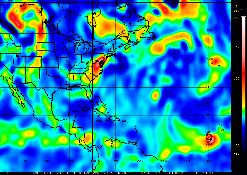
This has the vorticity of a tropical cyclone. All it needs is closed winds.


0 likes
-
Sciencerocks
- Category 5
- Posts: 7294
- Age: 38
- Joined: Thu Jul 06, 2017 1:51 am

-
cycloneye
- Admin
- Posts: 139519
- Age: 67
- Joined: Thu Oct 10, 2002 10:54 am
- Location: San Juan, Puerto Rico
Re: ATL: INVEST 91L - Discussion
A small area of low pressure and associated surface trough over
eastern Honduras is producing disorganized shower and thunderstorm
activity over portions of the western Caribbean Sea. A portion of
the low's circulation could move over the Gulf of Honduras on
Friday. However, development there, if any, is expected to be slow
to occur. This system could then move over the southwestern Gulf of
Mexico during the weekend, but by then unfavorable upper-level winds
are likely to limit significant development early next week while
the system moves northwestward or northward over the western Gulf
of Mexico. Regardless of development, heavy rains are possible
across portions of Central America and the Yucatan Peninsula through
the weekend.
* Formation chance through 48 hours...low...10 percent.
* Formation chance through 5 days...low...20 percent.
0 likes
Visit the Caribbean-Central America Weather Thread where you can find at first post web cams,radars
and observations from Caribbean basin members Click Here
and observations from Caribbean basin members Click Here
-
Extratropical94

- Professional-Met

- Posts: 3535
- Age: 29
- Joined: Wed Oct 20, 2010 6:36 am
- Location: Hamburg, Germany
- Contact:
Re: ATL: INVEST 91L - Discussion
A surface trough over the Gulf of Honduras and portions of Central
America is producing disorganized shower and thunderstorm activity.
This system is expected to move west-northwestward across Central
America and the Yucatan Peninsula, bringing heavy rains to that area
during the next couple of days. The disturbance is expected to move
over the southwestern Gulf of Mexico late this weekend, but
unfavorable upper-level winds could limit significant development
while the system moves northwestward or northward over the western
Gulf of Mexico early next week.
* Formation chance through 48 hours...low...near 0 percent.
* Formation chance through 5 days...low...30 percent.
0 likes
54° 11' 59'' N, 9° 9' 20'' E
Boomer Sooner!
Go Broncos! Go Cards! Go Niners!
- Daniel
Boomer Sooner!
Go Broncos! Go Cards! Go Niners!
- Daniel
-
tolakram
- Admin
- Posts: 19176
- Age: 60
- Joined: Sun Aug 27, 2006 8:23 pm
- Location: Florence, KY (name is Mark)
Re: ATL: INVEST 91L - Discussion
FYI all models are starting to see this in the gulf around the 72 hour range. TX to panhandle, but all see something.
2 likes
M a r k
- - - - -
Join us in chat: Storm2K Chatroom Invite. Android and IOS apps also available.
The posts in this forum are NOT official forecasts and should not be used as such. Posts are NOT endorsed by any professional institution or STORM2K.org. For official information and forecasts, please refer to NHC and NWS products.

Re: ATL: INVEST 91L - Discussion
tolakram wrote:FYI all models are starting to see this in the gulf around the 72 hour range. TX to panhandle, but all see something.
So far it just looks like rain for someone with lots of shear across the gulf.
0 likes
Personal Forecast Disclaimer:
The posts in this forum are NOT official forecast and should not be used as such. They are just the opinion of the poster and may or may not be backed by sound meteorological data. They are NOT endorsed by any professional institution or storm2k.org. For official information, please refer to the NHC and NWS products.
The posts in this forum are NOT official forecast and should not be used as such. They are just the opinion of the poster and may or may not be backed by sound meteorological data. They are NOT endorsed by any professional institution or storm2k.org. For official information, please refer to the NHC and NWS products.
Re: ATL: INVEST 91L - Discussion
The vort over Nicaragua looks like it has completely dissipated. If anything is to happen it would need to be under the convection. There is convergence at the low levels so you never know.
0 likes
-
HoustonFrog
- Tropical Depression

- Posts: 74
- Joined: Thu Jun 04, 2020 1:49 pm
Re: ATL: INVEST 91L - Discussion
Looks like the activity 10-14 days from now has better support. Who knows.
1 likes
Re: ATL: INVEST 91L - Discussion
HoustonFrog wrote:Looks like the activity 10-14 days from now has better support. Who knows.
Yep looks like there is some model support for a 2nd gulf storm in that time frame. Model guidance suggests that 2nd gulf storm could be stronger than what ever comes of 91L. Though I am starting to think we could get a named storm out of 91L probably just a sloppy rain maker but those can be pretty impactful as we have seen in the past.
1 likes

Re: ATL: INVEST 91L - Discussion
IcyTundra wrote:HoustonFrog wrote:Looks like the activity 10-14 days from now has better support. Who knows.
Yep looks like there is some model support for a 2nd gulf storm in that time frame. Model guidance suggests that 2nd gulf storm could be stronger than what ever comes of 91L. Though I am starting to think we could get a named storm out of 91L probably just a sloppy rain maker but
those can be pretty impactful as we have seen in the past.
I have a feeling this thread become a little longer then we thought?
0 likes
Harvey,Hanna,Beta,Texas Winter storm2021,Nicholas
-
TallyTracker
- Category 2

- Posts: 585
- Joined: Thu Oct 11, 2018 2:46 pm
Re: ATL: INVEST 91L - Discussion
I’m still watching this area for a quick classic BOC spin up. Doubt it’d be more than a weak sheared TS. Those are very common. It’d would very likely be nothing more than a rain-maker. The only problem I see is if it hits the same area Grace just hit. I’m not sure how saturated that area may be.
0 likes
Fran '96, Georges '98, Gordon '00, Gabrielle '01, Charley '04, Frances '04, Jeanne '04, Barry '07, Fay '08, Debby '12, Matthew '16, Emily '17, Irma '17, Michael ‘18, Elsa ‘21, Fred ‘21, Mindy ‘21, Nicole ‘22, Idalia ‘23

Re: ATL: INVEST 91L - Discussion
Anything in the Gulf needs to be watched. Fred, Grace, and Ida all peaked right before or at landfall, and despite the upwelling they’ve caused, a large swath of coastline from Mexico to far western Louisiana still has 30-31C SSTs. The rest of the Gulf is at least 28.5C. If UL conditions end up being favorable at any point in 91L’s time in the Gulf, it could spin up fast, and another landfall is the last thing Louisiana needs — even a little TS would complicate recovery efforts.
I wouldn’t write off 91L just because the models don’t produce a strong system, because they’ve underestimated a lot of systems over the last 14 months.
I wouldn’t write off 91L just because the models don’t produce a strong system, because they’ve underestimated a lot of systems over the last 14 months.
5 likes
Irene '11 Sandy '12 Hermine '16 5/15/2018 Derecho Fay '20 Isaias '20 Elsa '21 Henri '21 Ida '21
I am only a meteorology enthusiast who knows a decent amount about tropical cyclones. Look to the professional mets, the NHC, or your local weather office for the best information.
I am only a meteorology enthusiast who knows a decent amount about tropical cyclones. Look to the professional mets, the NHC, or your local weather office for the best information.
-
Tireman4

- S2K Supporter

- Posts: 5674
- Age: 58
- Joined: Fri Jun 30, 2006 1:08 pm
- Location: Humble, Texas
- Contact:
Re: ATL: INVEST 91L - Discussion
From the HGX NWS
We`ll also continue to monitor the southwestern Gulf waters for
possible tropical development (similar to yesterday, NHC`s 1 AM
CDT Tropical Weather Outlook has formation chance at only 20%
over the next five days). Moisture associated with this system
could eventually end up working its way into the central and
northern Gulf, and any tropical organization (depending on its
strength and and especially its location) could result in some
forecast changes for our area. The peak of the hurricane season
is coming, so please continue to keep an eye on the latest
available Tropical Weather Outlook from the NHC.
0 likes

Re: ATL: INVEST 91L - Discussion
People are already freaking out here locally on the Northshore. Local news posted a graphic of the lemon, and
Now Without context or explanation people are sharing it on Facebook thinking there’s another major on the way.
Now Without context or explanation people are sharing it on Facebook thinking there’s another major on the way.
0 likes
Who is online
Users browsing this forum: No registered users and 1 guest