ATL: FRED - Models
Moderator: S2k Moderators
- gatorcane
- S2K Supporter
- Posts: 23499
- Age: 46
- Joined: Sun Mar 13, 2005 3:54 pm
- Location: Boca Raton, FL
Re: ATL: 94L - Models
Remarkable agreement between the two big models on the day 8 forecast and both do not showing anything close to a hurricane:
0 likes
- Blown Away
- S2K Supporter
- Posts: 9870
- Joined: Wed May 26, 2004 6:17 am
Re: ATL: 94L - Models
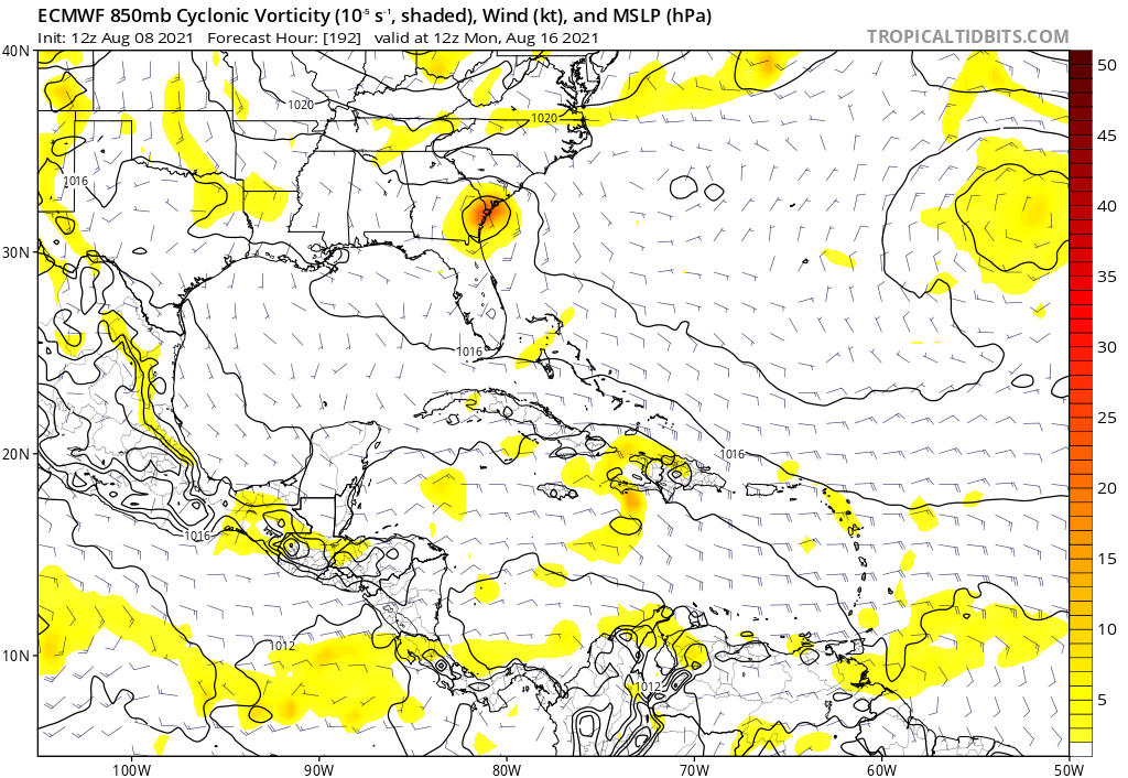
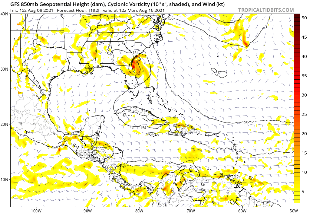
gatorcane wrote:Remarkable agreement between the two big models on the day 8 forecast and both do not showing anything close to a hurricane:
https://i.postimg.cc/KYrx8cbw/ecmwf-uv850-vort-watl-9.png
https://i.postimg.cc/ydLK0fkT/gfs-z850-vort-watl-33.png
Track yes, vorticity was much stronger on 12z EURO compared to all previous runs. No way to make conclusions at this point, especially on intensity. JMHO
0 likes
Hurricane Eye Experience: David 79, Irene 99, Frances 04, Jeanne 04, Wilma 05... EYE COMING MY WAY IN 2024…
Hurricane Brush Experience: Andrew 92, Erin 95, Floyd 99, Matthew 16, Irma 17, Ian 22, Nicole 22…
- captainbarbossa19
- Category 5
- Posts: 1040
- Joined: Wed Aug 21, 2019 11:09 pm
- Location: Starkville, MS
Re: ATL: 94L - Models
AtlanticWind wrote:Sometimes organizing systems take little jumps to the north during the process,
could make a difference for this system for clearing Hispanola to the north later on.
Some models are even suggesting a track just south of Hispaniola. We definitely need to see where the center forms. Nothing may happen, but I am leaning towards at least a TD/weak TS now.
0 likes
- Blown Away
- S2K Supporter
- Posts: 9870
- Joined: Wed May 26, 2004 6:17 am
Re: ATL: 94L - Models
captainbarbossa19 wrote:AtlanticWind wrote:Sometimes organizing systems take little jumps to the north during the process,
could make a difference for this system for clearing Hispanola to the north later on.
Some models are even suggesting a track just south of Hispaniola. We definitely need to see where the center forms. Nothing may happen, but I am leaning towards at least a TD/weak TS now.
18z...
0 likes
Hurricane Eye Experience: David 79, Irene 99, Frances 04, Jeanne 04, Wilma 05... EYE COMING MY WAY IN 2024…
Hurricane Brush Experience: Andrew 92, Erin 95, Floyd 99, Matthew 16, Irma 17, Ian 22, Nicole 22…
- SFLcane
- S2K Supporter
- Posts: 9621
- Age: 46
- Joined: Sat Jun 05, 2010 1:44 pm
- Location: Lake Worth Florida
Re: ATL: 94L - Models
Blown Away wrote:captainbarbossa19 wrote:AtlanticWind wrote:Sometimes organizing systems take little jumps to the north during the process,
could make a difference for this system for clearing Hispanola to the north later on.
Some models are even suggesting a track just south of Hispaniola. We definitely need to see where the center forms. Nothing may happen, but I am leaning towards at least a TD/weak TS now.
https://i.imgur.com/uCSrfiS.jpg
18z...
Hmm that misses the islands to the north.
0 likes
- captainbarbossa19
- Category 5
- Posts: 1040
- Joined: Wed Aug 21, 2019 11:09 pm
- Location: Starkville, MS
Re: ATL: 94L - Models
SFLcane wrote:Blown Away wrote:captainbarbossa19 wrote:
Some models are even suggesting a track just south of Hispaniola. We definitely need to see where the center forms. Nothing may happen, but I am leaning towards at least a TD/weak TS now.
https://i.imgur.com/uCSrfiS.jpg
18z...
Hmm that misses the islands to the north.
With ridging trending stronger to the north, I would not be surprised to see some south shifts. HWRF has this briefly passing south and then traveling across it. I guess I meant one model. Lol.
0 likes
Re: ATL: 94L - Models
Blown Away wrote:captainbarbossa19 wrote:AtlanticWind wrote:Sometimes organizing systems take little jumps to the north during the process,
could make a difference for this system for clearing Hispanola to the north later on.
Some models are even suggesting a track just south of Hispaniola. We definitely need to see where the center forms. Nothing may happen, but I am leaning towards at least a TD/weak TS now.
https://i.imgur.com/uCSrfiS.jpg
18z...
The 18z position is waaay off.
1 likes
- captainbarbossa19
- Category 5
- Posts: 1040
- Joined: Wed Aug 21, 2019 11:09 pm
- Location: Starkville, MS
Re: ATL: 94L - Models
Well not sure it's worth mentioning, but the NAVGEM and CMC both have a storm in the Gulf.
0 likes
- Hypercane_Kyle
- Category 5
- Posts: 2900
- Joined: Sat Mar 07, 2015 7:58 pm
- Location: Cape Canaveral, FL
Re: ATL: 94L - Models
Certainly a little bit more exciting in the Atlantic than it was just two days ago!
I doubt the HWRF will verify; it would need to develop incredibly fast for that to happen and that simply doesn't seem very likely at present.
0 likes
My posts are my own personal opinion, defer to the National Hurricane Center (NHC) and other NOAA products for decision making during hurricane season.
- Blown Away
- S2K Supporter
- Posts: 9870
- Joined: Wed May 26, 2004 6:17 am
Re: ATL: 94L - Models
xironman wrote:Blown Away wrote:captainbarbossa19 wrote:
Some models are even suggesting a track just south of Hispaniola. We definitely need to see where the center forms. Nothing may happen, but I am leaning towards at least a TD/weak TS now.
https://i.imgur.com/uCSrfiS.jpg
18z...
The 18z position is waaay off.
The NHC is tracking a broad circulation that is very near to the starting points of the 18z models...
2 likes
Hurricane Eye Experience: David 79, Irene 99, Frances 04, Jeanne 04, Wilma 05... EYE COMING MY WAY IN 2024…
Hurricane Brush Experience: Andrew 92, Erin 95, Floyd 99, Matthew 16, Irma 17, Ian 22, Nicole 22…
- AtlanticWind
- S2K Supporter
- Posts: 1806
- Age: 65
- Joined: Sun Aug 08, 2004 9:57 pm
- Location: Plantation,Fla
Re: ATL: 94L - Models
Hypercane_Kyle wrote:Certainly a little bit more exciting in the Atlantic than it was just two days ago!
I doubt the HWRF will verify; it would need to develop incredibly fast for that to happen and that simply doesn't seem very likely at present.
Dont think its really that fast ,Hwrf doesnt really get it going until after 24 hours.
1 likes
- Blown Away
- S2K Supporter
- Posts: 9870
- Joined: Wed May 26, 2004 6:17 am
Re: ATL: 94L - Models
12z HWRF... Develops 94L into sold Cat1/2 hurricane and just evaporates into the Hispaniola mountains...
0 likes
Hurricane Eye Experience: David 79, Irene 99, Frances 04, Jeanne 04, Wilma 05... EYE COMING MY WAY IN 2024…
Hurricane Brush Experience: Andrew 92, Erin 95, Floyd 99, Matthew 16, Irma 17, Ian 22, Nicole 22…
-
- Category 5
- Posts: 3950
- Age: 27
- Joined: Mon Aug 17, 2015 4:16 pm
- Location: Ft. Lauderdale, Florida
Re: ATL: 94L - Models
That HWRF makes sense track wise, OP models have been readjusting to a stronger ridge out in front.
0 likes
The posts in this forum are NOT official forecasts and should not be used as such. They are just the opinion of the poster and may or may not be backed by sound meteorological data. They are NOT endorsed by any professional institution or STORM2K. For official information, please refer to products from the NHC and NWS.
Model Runs Cheat Sheet:
GFS (5:30 AM/PM, 11:30 AM/PM)
HWRF, GFDL, UKMET, NAVGEM (6:30-8:00 AM/PM, 12:30-2:00 AM/PM)
ECMWF (1:45 AM/PM)
TCVN is a weighted averaged
- AtlanticWind
- S2K Supporter
- Posts: 1806
- Age: 65
- Joined: Sun Aug 08, 2004 9:57 pm
- Location: Plantation,Fla
Re: ATL: 94L - Models
AutoPenalti wrote:That HWRF makes sense track wise, OP models have been readjusting to a stronger ridge out in front.
Hwrf oftens trends to far west /south on systems. At least that what I have noticed.
0 likes
- captainbarbossa19
- Category 5
- Posts: 1040
- Joined: Wed Aug 21, 2019 11:09 pm
- Location: Starkville, MS
Re: ATL: 94L - Models
Blown Away wrote:captainbarbossa19 wrote:AtlanticWind wrote:Sometimes organizing systems take little jumps to the north during the process,
could make a difference for this system for clearing Hispanola to the north later on.
Some models are even suggesting a track just south of Hispaniola. We definitely need to see where the center forms. Nothing may happen, but I am leaning towards at least a TD/weak TS now.
https://i.imgur.com/uCSrfiS.jpg
18z...
Look familiar anyone track-wise?
0 likes
-
- S2K Supporter
- Posts: 6782
- Joined: Wed May 19, 2004 5:46 am
- Location: NE Fort Lauderdale
- Contact:
Re: ATL: 94L - Models
AtlanticWind wrote:AutoPenalti wrote:That HWRF makes sense track wise, OP models have been readjusting to a stronger ridge out in front.
Hwrf oftens trends to far west /south on systems. At least that what I have noticed.
Here we go again with the HWRF, be careful like real careful with HWRF intensity and to a lesser degree track.
0 likes
- AtlanticWind
- S2K Supporter
- Posts: 1806
- Age: 65
- Joined: Sun Aug 08, 2004 9:57 pm
- Location: Plantation,Fla
Re: ATL: 94L - Models
In case anybody hasn't seen the latest 12z Euro ensembles which more jump on board for development.
4 likes
- Spacecoast
- Category 2
- Posts: 687
- Joined: Thu Aug 31, 2017 2:03 pm
- AtlanticWind
- S2K Supporter
- Posts: 1806
- Age: 65
- Joined: Sun Aug 08, 2004 9:57 pm
- Location: Plantation,Fla
Who is online
Users browsing this forum: No registered users and 5 guests