EPAC: GUILLERMO - Post-Tropical
Moderator: S2k Moderators
-
Sciencerocks
- Category 5

- Posts: 7286
- Age: 38
- Joined: Thu Jul 06, 2017 1:51 am
-
Yellow Evan

- Professional-Met

- Posts: 15952
- Age: 25
- Joined: Fri Jul 15, 2011 12:48 pm
- Location: Henderson, Nevada/Honolulu, HI
- Contact:
Re: EPAC: SEVEN-E - Tropical Depression
* GFS version *
* EAST PACIFIC 2021 SHIPS INTENSITY FORECAST *
* IR SAT DATA AVAILABLE, OHC AVAILABLE *
* GUILLERMO EP072021 07/17/21 18 UTC *
TIME (HR) 0 6 12 18 24 36 48 60 72 84 96 108 120 132 144 156 168
V (KT) NO LAND 35 39 43 48 52 58 63 63 60 54 49 44 40 35 31 27 22
V (KT) LAND 35 39 43 48 52 58 63 63 60 54 49 44 40 35 31 27 22
V (KT) LGEM 35 38 41 44 46 50 50 48 43 39 35 33 31 29 26 23 21
Storm Type TROP TROP TROP TROP TROP TROP TROP TROP TROP TROP TROP TROP TROP TROP TROP TROP TROP
SHEAR (KT) 7 5 6 2 3 8 9 12 8 9 13 7 9 6 8 15 23
SHEAR ADJ (KT) -5 -1 3 4 4 7 4 2 2 1 1 2 0 0 0 1 1
SHEAR DIR 357 27 50 39 301 328 316 353 349 312 340 327 312 284 273 287 284
SST (C) 28.8 28.8 28.4 27.8 27.2 27.7 26.1 25.2 24.8 24.6 25.0 24.8 23.8 24.6 24.0 24.1 24.5
POT. INT. (KT) 153 153 149 142 136 142 125 116 112 110 114 112 101 110 104 105 110
200 MB T (C) -53.0 -52.5 -52.5 -52.6 -52.3 -52.0 -52.1 -52.0 -52.0 -51.8 -52.4 -52.5 -52.8 -52.9 -53.0 -53.0 -53.2
200 MB VXT (C) 0.0 -0.1 -0.1 -0.1 -0.1 0.1 0.3 0.3 0.3 0.4 0.8 0.9 0.5 0.5 0.4 0.5 0.3
TH_E DEV (C) 6 6 5 4 3 3 2 2 2 2 3 3 3 4 4 5 5
700-500 MB RH 72 70 69 69 66 63 60 59 57 52 48 46 42 40 39 37 36
MODEL VTX (KT) 15 16 17 18 19 21 24 23 22 20 19 17 15 13 11 9 6
850 MB ENV VOR 2 -2 -5 -1 0 -11 -3 3 19 41 63 71 60 56 38 30 1
200 MB DIV 26 49 73 63 57 49 16 13 -11 -5 -22 -23 -3 -3 -11 -27 -13
700-850 TADV -1 -6 -11 -7 -6 -19 -11 -14 -5 -5 -4 -2 2 1 7 6 9
LAND (KM) 550 619 612 625 658 822 966 1147 1373 1565 1776 2001 2198 1930 1662 1352 1020
LAT (DEG N) 16.9 17.3 17.6 17.9 18.1 18.2 18.3 18.5 18.3 18.2 18.1 18.0 17.7 xx.x xx.x xx.x xx.x
LONG(DEG W) 109.5 110.6 111.6 112.7 113.7 116.1 118.5 121.1 123.6 126.2 128.8 131.4 134.0 xxx.x xxx.x xxx.x xxx.x
STM SPEED (KT) 12 11 10 10 11 11 12 12 12 12 12 12 12 12 13 15 15
HEAT CONTENT 12 11 9 6 3 7 1 0 0 0 0 0 0 0 0 0 0
FORECAST TRACK FROM OFCI INITIAL HEADING/SPEED (DEG/KT):290/ 13 CX,CY: -11/ 4
T-12 MAX WIND: 30 PRESSURE OF STEERING LEVEL (MB): 621 (MEAN=587)
GOES IR BRIGHTNESS TEMP. STD DEV. 50-200 KM RAD: 15.4 (MEAN=14.5)
% GOES IR PIXELS WITH T < -20 C 50-200 KM RAD: 82.0 (MEAN=65.0)
PRELIM RI PROB (DV .GE. 35 KT IN 36 HR): 30.5
INDIVIDUAL CONTRIBUTIONS TO INTENSITY CHANGE
6 12 18 24 36 48 60 72 84 96 108 120 132 144 156 168
------------------------------------------------------------------------------
SAMPLE MEAN CHANGE 0. 0. 1. 1. 1. 2. 1. 1. 0. -0. -1. -2. -2. -3. -4. -4.
SST POTENTIAL 0. 1. 1. 3. 6. 10. 13. 16. 17. 18. 17. 16. 14. 12. 11. 10.
VERTICAL SHEAR MAG 1. 1. 3. 4. 5. 6. 6. 6. 6. 5. 5. 6. 6. 6. 5. 3.
VERTICAL SHEAR ADJ 0. 0. 0. -0. -1. -2. -2. -1. -1. -0. -0. -0. -0. -0. -0. -1.
VERTICAL SHEAR DIR 0. 0. 0. 0. -1. -1. -1. -2. -2. -2. -3. -3. -3. -3. -3. -3.
PERSISTENCE 1. 1. 1. 1. 1. 1. 1. 1. 1. 1. 1. 1. 1. 1. 1. 1.
200/250 MB TEMP. -0. -0. -0. -0. -1. -1. -1. -2. -2. -2. -1. -1. -0. 0. 1. 1.
THETA_E EXCESS -0. -0. -0. -1. -2. -3. -5. -6. -7. -8. -8. -8. -8. -8. -9. -10.
700-500 MB RH 0. 0. 0. 0. 0. 0. 0. 0. 0. -0. -0. -0. -1. -1. -2. -3.
MODEL VTX TENDENCY 0. 1. 2. 3. 4. 8. 9. 9. 6. 4. 2. -1. -2. -5. -6. -8.
850 MB ENV VORTICITY -0. -0. -0. -0. -0. 0. 0. 0. 1. 0. 0. 0. 0. 0. 0. 0.
200 MB DIVERGENCE -0. 0. 0. 0. 0. 0. 0. -0. -1. -2. -2. -2. -1. -0. 0. 1.
850-700 T ADVEC 0. 0. 0. 0. 0. -0. -0. -0. -0. -0. -1. -1. -1. -1. -1. -1.
ZONAL STORM MOTION 0. 0. 1. 1. 1. 2. 2. 2. 1. 1. 1. 1. 1. 1. 0. -0.
STEERING LEVEL PRES 0. 0. 0. 0. 1. 1. 1. 1. 1. 1. 1. 1. 1. 1. 1. 0.
DAYS FROM CLIM. PEAK -0. -0. -0. -0. -0. -0. -0. -1. -1. -1. -1. -1. -2. -2. -2. -3.
GOES PREDICTORS 1. 1. 1. 1. 1. 1. 1. 1. 0. 0. 0. 0. 0. -0. -0. -0.
OCEAN HEAT CONTENT -0. -0. -0. -0. -0. -1. -1. -1. -0. -0. 0. 1. 2. 2. 4. 6.
RI POTENTIAL 1. 2. 3. 4. 7. 6. 3. 1. -1. -2. -3. -3. -3. -3. -3. -3.
------------------------------------------------------------------------------
TOTAL CHANGE 4. 8. 13. 17. 23. 28. 28. 25. 19. 14. 9. 5. 0. -4. -8. -13.
CURRENT MAX WIND (KT): 35. LAT, LON: 16.9 109.5
** 2021 E. Pacific RI INDEX EP072021 GUILLERMO 07/17/21 18 UTC **
(SHIPS-RII PREDICTOR TABLE for 30 KT OR MORE MAXIMUM WIND INCREASE IN NEXT 24-h)
Predictor Value RI Predictor Range Scaled Value(0-1) % Contribution
POT = MPI-VMAX (KT) : 111.7 40.5 to 149.3 0.65 5.2
12 HR PERSISTENCE (KT) : 5.0 -22.0 to 44.0 0.41 3.7
D200 (10**7s-1) : 53.6 -33.0 to 159.5 0.45 3.3
850-200 MB SHEAR (KT) : 4.5 19.6 to 1.3 0.83 5.9
MAXIMUM WIND (KT) : 35.0 22.5 to 132.0 0.36 2.0
STD DEV OF IR BR TEMP : 15.4 37.8 to 2.1 0.63 3.2
BL DRY-AIR FLUX (W/M2) : 133.2 800.8 to -82.5 0.76 -4.2
HEAT CONTENT (KJ/CM2) : 8.2 2.7 to 106.7 0.05 0.2
%area of TPW <45 mm upshear : 5.8 56.6 to 0.0 0.90 1.4
2nd PC OF IR BR TEMP : 0.7 2.2 to -2.3 0.34 0.3
SHIPS Prob RI for 20kt/ 12hr RI threshold= 10% is 1.6 times climatological mean ( 6.3%)
SHIPS Prob RI for 25kt/ 24hr RI threshold= 24% is 1.9 times climatological mean (12.5%)
SHIPS Prob RI for 30kt/ 24hr RI threshold= 21% is 2.4 times climatological mean ( 8.6%)
SHIPS Prob RI for 35kt/ 24hr RI threshold= 20% is 3.2 times climatological mean ( 6.2%)
SHIPS Prob RI for 40kt/ 24hr RI threshold= 12% is 2.8 times climatological mean ( 4.2%)
SHIPS Prob RI for 45kt/ 36hr RI threshold= 19% is 2.9 times climatological mean ( 6.7%)
SHIPS Prob RI for 55kt/ 48hr RI threshold= 15% is 2.6 times climatological mean ( 5.9%)
SHIPS Prob RI for 65kt/ 72hr RI threshold= 0% is 0.0 times climatological mean ( 4.7%)
Matrix of RI probabilities
------------------------------------------------------------------------------
RI (kt / h) | 20/12 | 25/24 | 30/24 | 35/24 | 40/24 | 45/36 | 55/48 |65/72
------------------------------------------------------------------------------
SHIPS-RII: 10.4% 24.1% 21.1% 20.0% 11.7% 19.1% 15.4% 0.0%
Logistic: 5.9% 22.6% 12.5% 6.8% 1.2% 3.3% 0.4% 0.5%
Bayesian: 0.2% 0.8% 0.2% 0.1% 0.0% 0.0% 0.0% 0.0%
Consensus: 5.5% 15.8% 11.3% 9.0% 4.3% 7.5% 5.3% 0.2%
DTOPS: 3.0% 25.0% 16.0% 11.0% 7.0% 10.0% 10.0% 0.0%
## ANNULAR HURRICANE INDEX (AHI) EP072021 GUILLERMO 07/17/21 18 UTC ##
## STORM NOT ANNULAR, SCREENING STEP FAILED, NPASS=4 NFAIL=3 ##
## AHI= 0 (AHI OF 100 IS BEST FIT TO ANN. STRUC., 1 IS MARGINAL, 0 IS NOT ANNULAR) ##
0 likes
-
Kingarabian

- S2K Supporter

- Posts: 15434
- Joined: Sat Aug 08, 2009 3:06 am
- Location: Honolulu, Hawaii
Re: EPAC: GUILLERMO - Tropical Storm
Let' see if this one has any surprises up its sleeves. It too will have to become annular, but it will have to do so quickly. So it needs to become a hurricane within the next 36 hours, then take another 24 hours to transition to annular. Shear will generally be favorable.
0 likes
RIP Kobe Bryant
-
cycloneye

- Admin

- Posts: 139081
- Age: 67
- Joined: Thu Oct 10, 2002 10:54 am
- Location: San Juan, Puerto Rico
Re: EPAC: GUILLERMO - Tropical Storm
Tropical Storm Guillermo Discussion Number 2
NWS National Hurricane Center Miami FL EP072021
300 PM MDT Sat Jul 17 2021
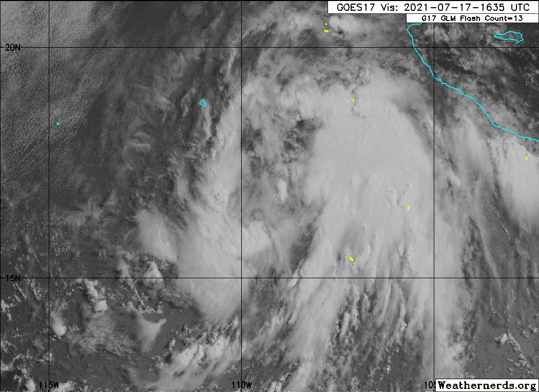
Fragmented convective banding has gradually increased since the
previous advisory, with a very tight low-level vortex having become
evident over the center in high-resolution visible satellite
imagery. Low-cloud motion vectors in the inner-core region have
been around 45 kt, which equals approximately 34-kt surface winds if
the cloud motions represent the 925-mb level. Satellite current
intensity (CI) estimates remain T2.5/35 kt from TAFB and and SAB.
The latest UW-CIMSS ADT estimate is T2.2/32 kt, with the raw and
adjusted T-numbers at 37 kt and 36 kt, respectively. Based on these
data, the intensity has been increased to 35 kt, making the cyclone
Tropical Storm Guillermo.
The initial motion estimate is 295/12 kt. There are no significant
changes to the previous track forecast or reasoning. The global and
regional models remain in very good agreement on Guillermo moving
west-northwestward today, and then turning toward the west later
tonight or early Sunday, with a general westward motion continuing
through day 3. By days 4 and 5, the deep-layer ridge to the north of
Guillermo is forecast by the models to gradually build southward,
forcing the tropical storm west-southwestward. The latest NHC model
guidance has converged tightly around the previous forecast track
through 96 h, so no adjustments were made. The new official forecast
track lies close to the tightly packed consensus models, which are
about midway between the stronger GFS track forecast on the right
side of the guidance envelope and the weaker ECMWF solution on the
left or south side.
Guillermo is expected to remain within a low vertical wind shear
regime and a moist mid-level environment, and over sea-surface
temperatures (SST) of at least 27C for the next 48 hours or so.
These favorable conditions should allow for at least modest
strengthening to occur during that time, with the only hindering
factor being Guillermo's large circulation. By 60 hours and beyond,
the cyclone will be moving over sub-26C SSTs, which should induce
gradual weakening despite the low vertical wind shear pattern. The
new NHC intensity forecast is similar to the previous advisory, and
closely follows the NOAA-HCCA corrected consensus model, which is
above most of the available intensity guidance.
FORECAST POSITIONS AND MAX WINDS
INIT 17/2100Z 17.1N 110.1W 35 KT 40 MPH
12H 18/0600Z 17.6N 111.7W 45 KT 50 MPH
24H 18/1800Z 18.0N 113.9W 50 KT 60 MPH
36H 19/0600Z 18.3N 116.2W 55 KT 65 MPH
48H 19/1800Z 18.4N 118.7W 55 KT 65 MPH
60H 20/0600Z 18.5N 121.2W 50 KT 60 MPH
72H 20/1800Z 18.4N 123.8W 45 KT 50 MPH
96H 21/1800Z 18.1N 128.9W 35 KT 40 MPH
120H 22/1800Z 17.8N 134.1W 30 KT 35 MPH
$$
Forecaster Stewart
NWS National Hurricane Center Miami FL EP072021
300 PM MDT Sat Jul 17 2021
Fragmented convective banding has gradually increased since the
previous advisory, with a very tight low-level vortex having become
evident over the center in high-resolution visible satellite
imagery. Low-cloud motion vectors in the inner-core region have
been around 45 kt, which equals approximately 34-kt surface winds if
the cloud motions represent the 925-mb level. Satellite current
intensity (CI) estimates remain T2.5/35 kt from TAFB and and SAB.
The latest UW-CIMSS ADT estimate is T2.2/32 kt, with the raw and
adjusted T-numbers at 37 kt and 36 kt, respectively. Based on these
data, the intensity has been increased to 35 kt, making the cyclone
Tropical Storm Guillermo.
The initial motion estimate is 295/12 kt. There are no significant
changes to the previous track forecast or reasoning. The global and
regional models remain in very good agreement on Guillermo moving
west-northwestward today, and then turning toward the west later
tonight or early Sunday, with a general westward motion continuing
through day 3. By days 4 and 5, the deep-layer ridge to the north of
Guillermo is forecast by the models to gradually build southward,
forcing the tropical storm west-southwestward. The latest NHC model
guidance has converged tightly around the previous forecast track
through 96 h, so no adjustments were made. The new official forecast
track lies close to the tightly packed consensus models, which are
about midway between the stronger GFS track forecast on the right
side of the guidance envelope and the weaker ECMWF solution on the
left or south side.
Guillermo is expected to remain within a low vertical wind shear
regime and a moist mid-level environment, and over sea-surface
temperatures (SST) of at least 27C for the next 48 hours or so.
These favorable conditions should allow for at least modest
strengthening to occur during that time, with the only hindering
factor being Guillermo's large circulation. By 60 hours and beyond,
the cyclone will be moving over sub-26C SSTs, which should induce
gradual weakening despite the low vertical wind shear pattern. The
new NHC intensity forecast is similar to the previous advisory, and
closely follows the NOAA-HCCA corrected consensus model, which is
above most of the available intensity guidance.
FORECAST POSITIONS AND MAX WINDS
INIT 17/2100Z 17.1N 110.1W 35 KT 40 MPH
12H 18/0600Z 17.6N 111.7W 45 KT 50 MPH
24H 18/1800Z 18.0N 113.9W 50 KT 60 MPH
36H 19/0600Z 18.3N 116.2W 55 KT 65 MPH
48H 19/1800Z 18.4N 118.7W 55 KT 65 MPH
60H 20/0600Z 18.5N 121.2W 50 KT 60 MPH
72H 20/1800Z 18.4N 123.8W 45 KT 50 MPH
96H 21/1800Z 18.1N 128.9W 35 KT 40 MPH
120H 22/1800Z 17.8N 134.1W 30 KT 35 MPH
$$
Forecaster Stewart
0 likes
Visit the Caribbean-Central America Weather Thread where you can find at first post web cams,radars
and observations from Caribbean basin members Click Here
and observations from Caribbean basin members Click Here
-
Kingarabian
- S2K Supporter
- Posts: 15434
- Joined: Sat Aug 08, 2009 3:06 am
- Location: Honolulu, Hawaii
Re: EPAC: GUILLERMO - Tropical Storm
cycloneye wrote:Tropical Storm Guillermo Discussion Number 2
NWS National Hurricane Center Miami FL EP072021
300 PM MDT Sat Jul 17 2021
Fragmented convective banding has gradually increased since the
previous advisory, with a very tight low-level vortex having become
evident over the center in high-resolution visible satellite
imagery. Low-cloud motion vectors in the inner-core region have
been around 45 kt, which equals approximately 34-kt surface winds if
the cloud motions represent the 925-mb level. Satellite current
intensity (CI) estimates remain T2.5/35 kt from TAFB and and SAB.
The latest UW-CIMSS ADT estimate is T2.2/32 kt, with the raw and
adjusted T-numbers at 37 kt and 36 kt, respectively. Based on these
data, the intensity has been increased to 35 kt, making the cyclone
Tropical Storm Guillermo.
The initial motion estimate is 295/12 kt. There are no significant
changes to the previous track forecast or reasoning. The global and
regional models remain in very good agreement on Guillermo moving
west-northwestward today, and then turning toward the west later
tonight or early Sunday, with a general westward motion continuing
through day 3. By days 4 and 5, the deep-layer ridge to the north of
Guillermo is forecast by the models to gradually build southward,
forcing the tropical storm west-southwestward. The latest NHC model
guidance has converged tightly around the previous forecast track
through 96 h, so no adjustments were made. The new official forecast
track lies close to the tightly packed consensus models, which are
about midway between the stronger GFS track forecast on the right
side of the guidance envelope and the weaker ECMWF solution on the
left or south side.
Guillermo is expected to remain within a low vertical wind shear
regime and a moist mid-level environment, and over sea-surface
temperatures (SST) of at least 27C for the next 48 hours or so.
These favorable conditions should allow for at least modest
strengthening to occur during that time, with the only hindering
factor being Guillermo's large circulation. By 60 hours and beyond,
the cyclone will be moving over sub-26C SSTs, which should induce
gradual weakening despite the low vertical wind shear pattern. The
new NHC intensity forecast is similar to the previous advisory, and
closely follows the NOAA-HCCA corrected consensus model, which is
above most of the available intensity guidance.
FORECAST POSITIONS AND MAX WINDS
INIT 17/2100Z 17.1N 110.1W 35 KT 40 MPH
12H 18/0600Z 17.6N 111.7W 45 KT 50 MPH
24H 18/1800Z 18.0N 113.9W 50 KT 60 MPH
36H 19/0600Z 18.3N 116.2W 55 KT 65 MPH
48H 19/1800Z 18.4N 118.7W 55 KT 65 MPH
60H 20/0600Z 18.5N 121.2W 50 KT 60 MPH
72H 20/1800Z 18.4N 123.8W 45 KT 50 MPH
96H 21/1800Z 18.1N 128.9W 35 KT 40 MPH
120H 22/1800Z 17.8N 134.1W 30 KT 35 MPH
$$
Forecaster Stewart
AKA please behave and go according to forecast.
0 likes
RIP Kobe Bryant
-
Yellow Evan
- Professional-Met
- Posts: 15952
- Age: 25
- Joined: Fri Jul 15, 2011 12:48 pm
- Location: Henderson, Nevada/Honolulu, HI
- Contact:
Re: EPAC: GUILLERMO - Tropical Storm
Kingarabian wrote:Let' see if this one has any surprises up its sleeves. It too will have to become annular, but it will have to do so quickly. So it needs to become a hurricane within the next 36 hours, then take another 24 hours to transition to annular. Shear will generally be favorable.
The biggest problem is it’s large size. A climatological rate of intensification of T1/day would favor a T4.5 in two days when the storm hits the 26C isotherm.
2 likes
-
Yellow Evan
- Professional-Met
- Posts: 15952
- Age: 25
- Joined: Fri Jul 15, 2011 12:48 pm
- Location: Henderson, Nevada/Honolulu, HI
- Contact:
Re: EPAC: GUILLERMO - Tropical Storm
TXPZ26 KNES 172359
TCSENP
A. 07E (GUILLERMO)
B. 17/2330Z
C. 16.7N
D. 109.8W
E. THREE/GOES-W
F. T2.0/2.5
G. IR/EIR/VIS
H. REMARKS...5/10 BANDING AROUND THE LLCC YIELDS A DT OF 2.5. MET AND
PT ARE EQUAL TO A 2.0 BASED ON A SLIGHT DEVELOPMENT TREND IN THE LAST
24 HOURS. FT IS BASED ON MET AS BANDING FEATURE IS NOT CLEAR CUT.
I. ADDL POSITIONS
NIL
...TUGGLE
0 likes
-
cycloneye
- Admin
- Posts: 139081
- Age: 67
- Joined: Thu Oct 10, 2002 10:54 am
- Location: San Juan, Puerto Rico
Re: EPAC: GUILLERMO - Tropical Storm
07E GUILLERMO 210718 0000 17.3N 110.6W EPAC 35 1004
0 likes
Visit the Caribbean-Central America Weather Thread where you can find at first post web cams,radars
and observations from Caribbean basin members Click Here
and observations from Caribbean basin members Click Here
-
Sciencerocks
- Category 5
- Posts: 7286
- Age: 38
- Joined: Thu Jul 06, 2017 1:51 am
-
cycloneye
- Admin
- Posts: 139081
- Age: 67
- Joined: Thu Oct 10, 2002 10:54 am
- Location: San Juan, Puerto Rico
Re: EPAC: GUILLERMO - Tropical Storm
Tropical Storm Guillermo Discussion Number 3
NWS National Hurricane Center Miami FL EP072021
900 PM MDT Sat Jul 17 2021
The overall structure of Guillermo has changed little since this
afternoon, with the only notable difference being a small burst of
deep convection just to the southwest of the center. Recent
satellite imagery suggests that the system is tilted, with the
mid-level circulation offset a bit to the northeast from the
low-level center. Guillermo is a large tropical cyclone, and the
sprawling circulation of the storm is producing broken banding over
an area over 400 n mi wide. The latest T-numbers from TAFB and the
UW-CIMSS ADT have also changed little since 6 h ago, which suggest
that the Guillermo's initial intensity remains 35 kt.
A fortuitous AMSR2 microwave overpass helped to confirm the
location of Guillermo's low-level center a few hours ago, and the
initial motion estimate is 290/11 kt. The cyclone is expected to
turn to the west on Sunday as it becomes embedded in easterly flow
to the south of a mid-level ridge. This ridge should remain in
place through the early part of next week. By 72 h, the guidance is
suggesting that Guillermo will become a shallow cyclone, and a
large low-level ridge to its northwest will become the primary
steering mechanism, resulting a slightly south-of-west motion. The
official NHC forecast is near the previous one through 60 h, but is
a little faster and slightly to the south of it thereafter.
Due to the large size of Guillermo's circulation, it may take
longer than normal for the cyclone to develop a tight wind field,
despite being in an environment of low vertical wind shear and over
warm waters. Therefore, only gradual strengthening is indicated
over the next 36 h. After 36 h, the forecast track of the cyclone
takes it over cooler waters with SSTs less than 25C by 60 h. There
are also indications that Guillermo will encounter moderate
northwesterly shear in a few days, which would entrain stable air
located to its north into the circulation. These factors should
cause steady weakening beginning in a couple of days. And although
not shown in the official forecast, several of the convection
allowing models show the cyclone losing most, if not all, of its
deep convection and becoming a remnant low by the end of the
forecast period. Since Guillermo's forecast track keeps it fairly
close to a tight SST gradient, with warmer waters just south, it is
possible that a small deviation of the track to the south could
prevent the cyclone from becoming a remnant low so soon. The
latest NHC intensity forecast is slightly lower than the previous
one due to a decrease in the overall intensity guidance, yet remains
on the high end of the guidance through 36 h.
FORECAST POSITIONS AND MAX WINDS
INIT 18/0300Z 17.5N 111.1W 35 KT 40 MPH
12H 18/1200Z 17.9N 112.6W 40 KT 45 MPH
24H 19/0000Z 18.3N 114.8W 50 KT 60 MPH
36H 19/1200Z 18.5N 117.4W 50 KT 60 MPH
48H 20/0000Z 18.7N 120.1W 45 KT 50 MPH
60H 20/1200Z 18.6N 122.9W 40 KT 45 MPH
72H 21/0000Z 18.4N 125.5W 35 KT 40 MPH
96H 22/0000Z 17.9N 130.7W 30 KT 35 MPH
120H 23/0000Z 17.5N 136.0W 30 KT 35 MPH
$$
Forecaster Latto
0 likes
Visit the Caribbean-Central America Weather Thread where you can find at first post web cams,radars
and observations from Caribbean basin members Click Here
and observations from Caribbean basin members Click Here
-
Yellow Evan
- Professional-Met
- Posts: 15952
- Age: 25
- Joined: Fri Jul 15, 2011 12:48 pm
- Location: Henderson, Nevada/Honolulu, HI
- Contact:
Re: EPAC: GUILLERMO - Tropical Storm
This is a WPAC style mess that will take days to organize, which Guillermo does not have.
0 likes
-
Astromanía
- Category 2

- Posts: 737
- Age: 25
- Joined: Sat Aug 25, 2018 10:34 pm
- Location: Monterrey, N.L, México
-
Yellow Evan
- Professional-Met
- Posts: 15952
- Age: 25
- Joined: Fri Jul 15, 2011 12:48 pm
- Location: Henderson, Nevada/Honolulu, HI
- Contact:
Re: EPAC: GUILLERMO - Tropical Storm
Seems to have evolved from monsoonal curved band to a shear pattern unexpectedly.
0 likes
-
Yellow Evan
- Professional-Met
- Posts: 15952
- Age: 25
- Joined: Fri Jul 15, 2011 12:48 pm
- Location: Henderson, Nevada/Honolulu, HI
- Contact:
Re: EPAC: GUILLERMO - Tropical Storm
TXPZ26 KNES 180554
TCSENP
A. 07E (GUILLERMO)
B. 18/0530Z
C. 17.0N
D. 110.6W
E. THREE/GOES-W
F. T3.0/3.0
G. IR/EIR/SWIR
H. REMARKS...8.5/10 BANDING AROUND THE LLCC YIELDS A DT OF 3.5. MET
AND PT ARE EQUAL TO 3.0 BASED ON A DEVELOPMENT TREND IN THE LAST 24
HOURS. FT IS BASED ON MET AS BANDING FEATURES ARE NOT CLEAR CUT DUE TO
INCONSISTENT CONVECTION.
I. ADDL POSITIONS
NIL
...TUGGLE
Why isn't a shear pattern being used?
0 likes
-
ElectricStorm

- Category 5
- Posts: 4542
- Age: 23
- Joined: Tue Aug 13, 2019 11:23 pm
- Location: Skiatook, OK / Norman, OK
Re: EPAC: GUILLERMO - Tropical Storm
07E GUILLERMO 210718 0600 17.5N 111.1W EPAC 45 1000
0 likes
I am in no way a professional. Take what I say with a grain of salt as I could be totally wrong. Please refer to the NHC, NWS, or SPC for official information.
Boomer Sooner!
Boomer Sooner!
-
Yellow Evan
- Professional-Met
- Posts: 15952
- Age: 25
- Joined: Fri Jul 15, 2011 12:48 pm
- Location: Henderson, Nevada/Honolulu, HI
- Contact:
Re: EPAC: GUILLERMO - Tropical Storm
* GFS version *
* EAST PACIFIC 2021 SHIPS INTENSITY FORECAST *
* IR SAT DATA AVAILABLE, OHC AVAILABLE *
* GUILLERMO EP072021 07/18/21 06 UTC *
TIME (HR) 0 6 12 18 24 36 48 60 72 84 96 108 120 132 144 156 168
V (KT) NO LAND 45 48 51 53 55 55 53 49 42 36 32 28 25 22 20 17 N/A
V (KT) LAND 45 48 51 53 55 55 53 49 42 36 32 28 25 22 20 17 N/A
V (KT) LGEM 45 49 51 53 53 51 46 39 34 30 28 26 24 22 20 18 16
Storm Type TROP TROP TROP TROP TROP TROP TROP TROP TROP TROP TROP TROP TROP TROP TROP TROP TROP
SHEAR (KT) 6 5 7 10 12 8 16 15 13 14 9 8 8 9 18 23 35
SHEAR ADJ (KT) 1 1 2 3 4 6 -1 -2 -1 -2 1 1 0 2 4 1 -2
SHEAR DIR 351 331 318 331 345 285 327 349 347 356 340 320 296 285 289 290 266
SST (C) 28.6 28.1 27.5 27.0 27.7 26.0 25.2 24.6 24.5 25.1 25.1 23.9 24.6 24.1 24.3 24.6 24.7
POT. INT. (KT) 151 145 139 135 142 125 116 110 109 115 115 102 110 105 107 111 111
200 MB T (C) -52.7 -52.8 -52.6 -52.2 -52.3 -52.0 -52.2 -52.2 -52.3 -52.7 -52.9 -53.1 -53.2 -53.4 -53.3 -53.4 -53.6
200 MB VXT (C) -0.1 -0.2 -0.1 -0.1 0.0 0.1 0.1 0.3 0.5 0.6 0.7 0.7 0.5 0.4 0.2 0.5 -0.3
TH_E DEV (C) 6 5 4 4 3 2 2 2 2 3 4 4 4 5 6 6 7
700-500 MB RH 69 70 67 66 62 59 58 58 55 51 47 45 44 42 39 37 37
MODEL VTX (KT) 16 17 17 18 19 20 20 18 16 14 13 11 10 7 6 4 3
850 MB ENV VOR 0 1 1 -5 -18 -4 -3 9 31 48 56 48 46 25 18 -10 -23
200 MB DIV 71 64 66 46 40 28 7 -13 -16 -8 -19 1 -12 -8 -28 -1 -15
700-850 TADV -11 -3 -2 -12 -20 -11 -20 -10 -6 -2 -3 0 0 7 10 7 6
LAND (KM) 611 607 623 691 775 920 1132 1372 1558 1784 2029 2181 1921 1635 1332 1020 699
LAT (DEG N) 17.5 17.8 18.1 18.2 18.3 18.6 18.6 18.4 18.3 18.0 17.7 17.5 17.4 xx.x xx.x xx.x xx.x
LONG(DEG W) 111.1 112.1 113.1 114.3 115.6 118.2 121.0 123.7 126.2 128.8 131.5 134.2 136.7 xxx.x xxx.x xxx.x xxx.x
STM SPEED (KT) 10 10 11 12 12 13 13 12 12 13 13 12 12 14 14 15 14
HEAT CONTENT 10 8 5 3 6 0 0 0 0 0 0 0 0 0 0 0 0
FORECAST TRACK FROM OFCI INITIAL HEADING/SPEED (DEG/KT):285/ 10 CX,CY: -9/ 3
T-12 MAX WIND: 35 PRESSURE OF STEERING LEVEL (MB): 565 (MEAN=587)
GOES IR BRIGHTNESS TEMP. STD DEV. 50-200 KM RAD: 19.4 (MEAN=14.5)
% GOES IR PIXELS WITH T < -20 C 50-200 KM RAD: 63.0 (MEAN=65.0)
PRELIM RI PROB (DV .GE. 35 KT IN 36 HR): 18.1
INDIVIDUAL CONTRIBUTIONS TO INTENSITY CHANGE
6 12 18 24 36 48 60 72 84 96 108 120 132 144 156 168
------------------------------------------------------------------------------
SAMPLE MEAN CHANGE 0. 0. 1. 1. 1. 2. 1. 1. 0. -0. -1. -2. -2. -3. -4. -4.
SST POTENTIAL 1. 1. 2. 3. 5. 6. 8. 8. 8. 8. 7. 5. 3. 0. -1. -3.
VERTICAL SHEAR MAG 1. 1. 2. 2. 4. 4. 3. 2. 1. 0. 1. 1. 2. 1. -1. -4.
VERTICAL SHEAR ADJ -0. -0. -0. -1. -2. -2. -1. -0. -0. -0. -0. -0. -0. -0. -0. -0.
VERTICAL SHEAR DIR -0. -0. -1. -1. -1. -2. -2. -3. -3. -3. -3. -3. -4. -3. -3. -3.
PERSISTENCE 2. 3. 3. 3. 3. 2. 2. 2. 1. 1. 1. 2. 1. 1. 1. 1.
200/250 MB TEMP. -0. -0. -0. -0. -1. -1. -1. -1. -1. -1. -0. -0. 0. 0. 1. 1.
THETA_E EXCESS -0. -0. -1. -1. -3. -4. -5. -6. -7. -8. -8. -8. -8. -8. -8. -9.
700-500 MB RH 0. 0. 0. 0. 0. 0. 0. -0. -0. -0. -0. -1. -1. -1. -2. -3.
MODEL VTX TENDENCY 0. 1. 1. 3. 3. 3. 2. -1. -4. -5. -7. -8. -10. -10. -11. -10.
850 MB ENV VORTICITY -0. -0. -0. -0. -0. 0. 0. 0. 0. 0. 0. 0. 0. 0. 0. 0.
200 MB DIVERGENCE 0. 0. 0. 0. 0. 0. -1. -1. -2. -2. -2. -2. -2. -1. 0. 1.
850-700 T ADVEC 0. 0. 0. 0. 0. -0. -0. -0. -0. -0. -1. -1. -1. -1. -1. -1.
ZONAL STORM MOTION 0. 0. 0. 0. 1. 1. 1. 1. 1. 0. 0. 0. 0. 0. 0. -0.
STEERING LEVEL PRES -0. -0. -0. -0. -0. -0. -0. -0. -0. -0. -0. -0. -0. -0. -0. -0.
DAYS FROM CLIM. PEAK -0. -0. -0. -0. -0. -0. -0. -1. -1. -1. -1. -1. -2. -2. -2. -3.
GOES PREDICTORS -0. -1. -1. -1. -1. -1. -2. -2. -2. -2. -3. -3. -3. -2. -2. -1.
OCEAN HEAT CONTENT -0. -0. -0. -0. -0. -1. -1. -1. -0. -0. 0. 1. 2. 3. 4. 6.
RI POTENTIAL 0. 1. 1. 2. 2. 2. 1. 0. -0. -0. -0. 0. 0. 0. 0. 0.
------------------------------------------------------------------------------
TOTAL CHANGE 3. 6. 8. 10. 10. 8. 4. -3. -9. -13. -17. -20. -23. -25. -28. -31.
CURRENT MAX WIND (KT): 45. LAT, LON: 17.5 111.1
** 2021 E. Pacific RI INDEX EP072021 GUILLERMO 07/18/21 06 UTC **
(SHIPS-RII PREDICTOR TABLE for 30 KT OR MORE MAXIMUM WIND INCREASE IN NEXT 24-h)
Predictor Value RI Predictor Range Scaled Value(0-1) % Contribution
POT = MPI-VMAX (KT) : 97.4 40.5 to 149.3 0.52 4.2
12 HR PERSISTENCE (KT) : 10.0 -22.0 to 44.0 0.48 4.4
D200 (10**7s-1) : 57.4 -33.0 to 159.5 0.47 3.5
850-200 MB SHEAR (KT) : 8.0 19.6 to 1.3 0.64 4.5
MAXIMUM WIND (KT) : 45.0 22.5 to 132.0 0.64 3.6
STD DEV OF IR BR TEMP : 19.4 37.8 to 2.1 0.52 2.6
BL DRY-AIR FLUX (W/M2) : 204.6 800.8 to -82.5 0.67 -3.8
HEAT CONTENT (KJ/CM2) : 6.4 2.7 to 106.7 0.04 0.2
%area of TPW <45 mm upshear : 5.8 56.6 to 0.0 0.90 1.4
2nd PC OF IR BR TEMP : 0.1 2.2 to -2.3 0.48 0.4
SHIPS Prob RI for 20kt/ 12hr RI threshold= 12% is 2.0 times climatological mean ( 6.3%)
SHIPS Prob RI for 25kt/ 24hr RI threshold= 23% is 1.8 times climatological mean (12.5%)
SHIPS Prob RI for 30kt/ 24hr RI threshold= 21% is 2.4 times climatological mean ( 8.6%)
SHIPS Prob RI for 35kt/ 24hr RI threshold= 20% is 3.3 times climatological mean ( 6.2%)
SHIPS Prob RI for 40kt/ 24hr RI threshold= 12% is 2.8 times climatological mean ( 4.2%)
SHIPS Prob RI for 45kt/ 36hr RI threshold= 19% is 2.8 times climatological mean ( 6.7%)
SHIPS Prob RI for 55kt/ 48hr RI threshold= 0% is 0.0 times climatological mean ( 5.9%)
SHIPS Prob RI for 65kt/ 72hr RI threshold= 0% is 0.0 times climatological mean ( 4.7%)
Matrix of RI probabilities
------------------------------------------------------------------------------
RI (kt / h) | 20/12 | 25/24 | 30/24 | 35/24 | 40/24 | 45/36 | 55/48 |65/72
------------------------------------------------------------------------------
SHIPS-RII: 12.3% 23.0% 21.0% 20.2% 11.8% 18.5% 0.0% 0.0%
Logistic: 6.7% 12.1% 6.9% 2.9% 0.7% 1.2% 0.1% 0.1%
Bayesian: 0.7% 0.2% 0.0% 0.0% 0.0% 0.0% 0.0% 0.0%
Consensus: 6.6% 11.8% 9.3% 7.7% 4.2% 6.6% 0.0% 0.0%
DTOPS: 4.0% 14.0% 8.0% 7.0% 4.0% 4.0% 1.0% 0.0%
## ANNULAR HURRICANE INDEX (AHI) EP072021 GUILLERMO 07/18/21 06 UTC ##
## STORM NOT ANNULAR, SCREENING STEP FAILED, NPASS=4 NFAIL=3 ##
## AHI= 0 (AHI OF 100 IS BEST FIT TO ANN. STRUC., 1 IS MARGINAL, 0 IS NOT ANNULAR) ##
0 likes
-
cycloneye
- Admin
- Posts: 139081
- Age: 67
- Joined: Thu Oct 10, 2002 10:54 am
- Location: San Juan, Puerto Rico
Re: EPAC: GUILLERMO - Tropical Storm
Tropical Storm Guillermo Discussion Number 4
NWS National Hurricane Center Miami FL EP072021
300 AM MDT Sun Jul 18 2021
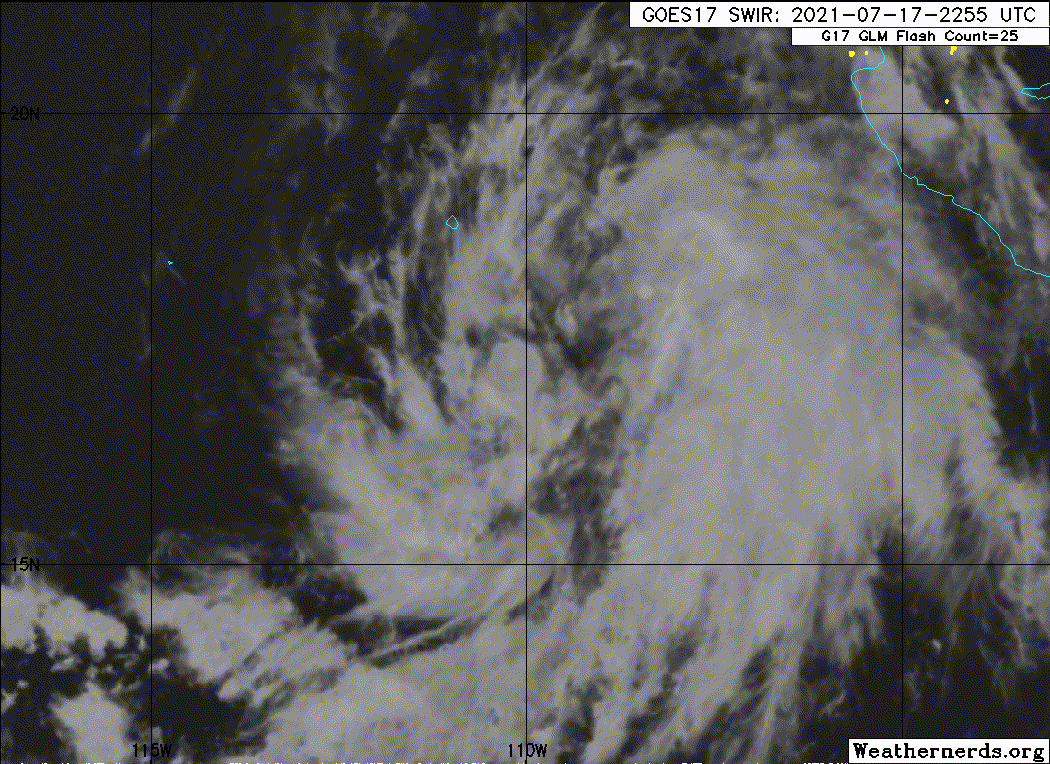
Guillermo has become a little better organized, with more deep
convection concentrated near the estimated center, and some banding
features trying to develop over the southern part of the
circulation. Upper-level outflow is fairly well-defined over the
southern semicircle as well. The latest Dvorak intensity estimates
from both TAFB and SAB are 45 kt, and this is used for the advisory
intensity. Scatterometer data from ASCAT-A suggest that this may be
a somewhat generous intensity estimate, but the ASCAT-B and ASCAT-C
sensors did not sample the strongest part of the circulation.
There is still considerable scatter in the center fixes from
geostationary imagery. Blending these fixes with additional center
positions from microwave imagery yields a slightly slower forward
motion of about 285/10 kt. A mid-level ridge should be established
to the north of Guillermo for the next several days. This is
likely to result in a generally westward track at a faster forward
speed through most of the forecast period. Late in the period, a
slight bend toward the west-southwest is expected as the weakening
cyclone is influenced more by the low-level flow. The official
track forecast is quite close to the previous one and is near, or a
little slower than, the latest multi-model consensus.
Some additional strengthening is anticipated while the system is in
a relatively low shear environment during the next day or so.
However, the SHIPS model indicates some increase in northwesterly
shear in 1-2 days. Thereafter, SSTs beneath Guillermo should
decrease. These changes should lead to a leveling off of the
intensity, followed by gradual weakening. The NHC intensity forecast
is near or above the model consensus, IVCN, and is also very similar
to the latest HWRF model prediction.
FORECAST POSITIONS AND MAX WINDS
INIT 18/0900Z 17.6N 111.6W 45 KT 50 MPH
12H 18/1800Z 18.0N 113.1W 50 KT 60 MPH
24H 19/0600Z 18.4N 115.5W 55 KT 65 MPH
36H 19/1800Z 18.7N 118.2W 55 KT 65 MPH
48H 20/0600Z 18.7N 120.9W 50 KT 60 MPH
60H 20/1800Z 18.7N 123.8W 40 KT 45 MPH
72H 21/0600Z 18.5N 126.8W 35 KT 40 MPH
96H 22/0600Z 18.0N 132.0W 30 KT 35 MPH
120H 23/0600Z 17.5N 137.0W 30 KT 35 MPH
$$
Forecaster Pasch
NWS National Hurricane Center Miami FL EP072021
300 AM MDT Sun Jul 18 2021
Guillermo has become a little better organized, with more deep
convection concentrated near the estimated center, and some banding
features trying to develop over the southern part of the
circulation. Upper-level outflow is fairly well-defined over the
southern semicircle as well. The latest Dvorak intensity estimates
from both TAFB and SAB are 45 kt, and this is used for the advisory
intensity. Scatterometer data from ASCAT-A suggest that this may be
a somewhat generous intensity estimate, but the ASCAT-B and ASCAT-C
sensors did not sample the strongest part of the circulation.
There is still considerable scatter in the center fixes from
geostationary imagery. Blending these fixes with additional center
positions from microwave imagery yields a slightly slower forward
motion of about 285/10 kt. A mid-level ridge should be established
to the north of Guillermo for the next several days. This is
likely to result in a generally westward track at a faster forward
speed through most of the forecast period. Late in the period, a
slight bend toward the west-southwest is expected as the weakening
cyclone is influenced more by the low-level flow. The official
track forecast is quite close to the previous one and is near, or a
little slower than, the latest multi-model consensus.
Some additional strengthening is anticipated while the system is in
a relatively low shear environment during the next day or so.
However, the SHIPS model indicates some increase in northwesterly
shear in 1-2 days. Thereafter, SSTs beneath Guillermo should
decrease. These changes should lead to a leveling off of the
intensity, followed by gradual weakening. The NHC intensity forecast
is near or above the model consensus, IVCN, and is also very similar
to the latest HWRF model prediction.
FORECAST POSITIONS AND MAX WINDS
INIT 18/0900Z 17.6N 111.6W 45 KT 50 MPH
12H 18/1800Z 18.0N 113.1W 50 KT 60 MPH
24H 19/0600Z 18.4N 115.5W 55 KT 65 MPH
36H 19/1800Z 18.7N 118.2W 55 KT 65 MPH
48H 20/0600Z 18.7N 120.9W 50 KT 60 MPH
60H 20/1800Z 18.7N 123.8W 40 KT 45 MPH
72H 21/0600Z 18.5N 126.8W 35 KT 40 MPH
96H 22/0600Z 18.0N 132.0W 30 KT 35 MPH
120H 23/0600Z 17.5N 137.0W 30 KT 35 MPH
$$
Forecaster Pasch
0 likes
Visit the Caribbean-Central America Weather Thread where you can find at first post web cams,radars
and observations from Caribbean basin members Click Here
and observations from Caribbean basin members Click Here
-
cycloneye
- Admin
- Posts: 139081
- Age: 67
- Joined: Thu Oct 10, 2002 10:54 am
- Location: San Juan, Puerto Rico
Re: EPAC: GUILLERMO - Tropical Storm
07E GUILLERMO 210718 1200 17.8N 112.0W EPAC 45 1000
0 likes
Visit the Caribbean-Central America Weather Thread where you can find at first post web cams,radars
and observations from Caribbean basin members Click Here
and observations from Caribbean basin members Click Here
-
Yellow Evan
- Professional-Met
- Posts: 15952
- Age: 25
- Joined: Fri Jul 15, 2011 12:48 pm
- Location: Henderson, Nevada/Honolulu, HI
- Contact:
Re: EPAC: GUILLERMO - Tropical Storm
TXPZ26 KNES 181256
TCSENP
CCA
A. 07E (GUILLERMO)
B. 18/1130Z
C. 17.9N
D. 111.9W
E. THREE/GOES-W
F. T3.0/3.0
G. IR/EIR/SWIR/AMSR2
H. REMARKS...CORRECTED FOR ANALYST. 10/10 BANDING RESULTS IN A DT OF
3.5. MET AND PT=3.0. FT IS BASED ON MET DUE TO PULSING/IRREG CONVECTION.
I. ADDL POSITIONS
18/0855Z 17.8N 111.5W AMSR2
...KONON
0 likes
-
Sciencerocks
- Category 5
- Posts: 7286
- Age: 38
- Joined: Thu Jul 06, 2017 1:51 am

Who is online
Users browsing this forum: No registered users and 75 guests