EPAC: KEVIN - Post-Tropical

Moderator: S2k Moderators

Message
Author
User avatar
cycloneye
Admin
Admin
Posts: 139059
Age: 67
Joined: Thu Oct 10, 2002 10:54 am
Location: San Juan, Puerto Rico

Re: EPAC: KEVIN - Tropical Storm

#101 Postby cycloneye » Mon Aug 09, 2021 3:43 pm

Tropical Storm Kevin Discussion Number 10
NWS National Hurricane Center Miami FL EP112021
300 PM MDT Mon Aug 09 2021

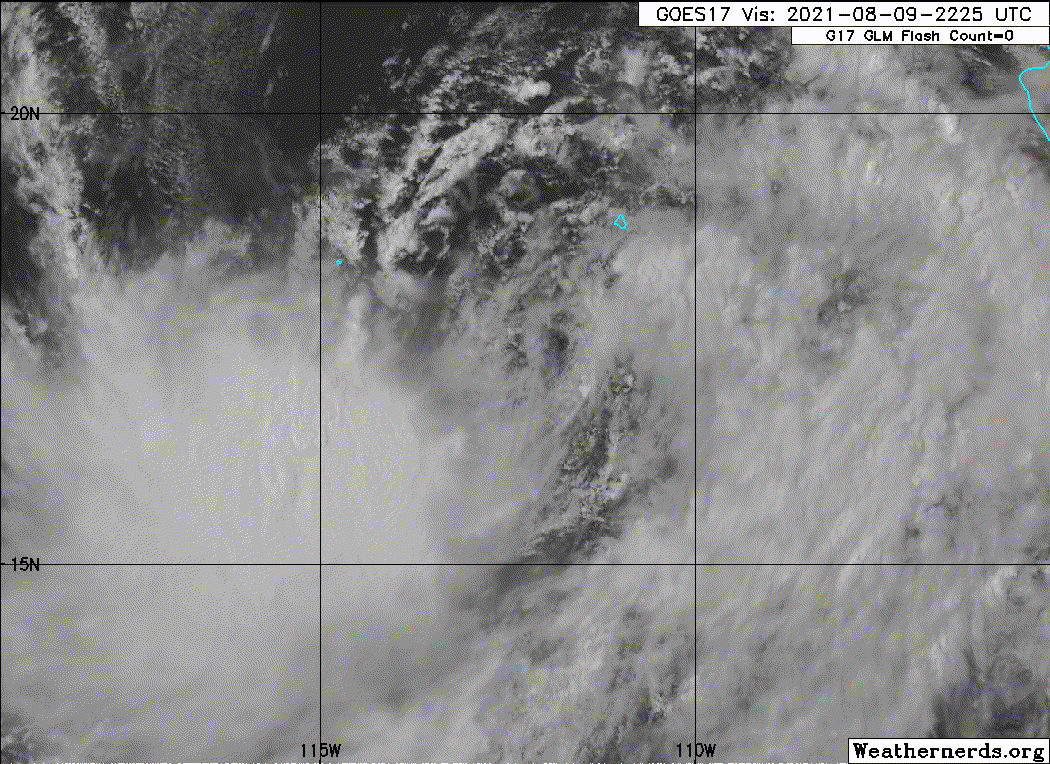
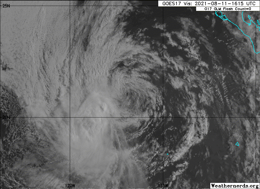
Visible satellite imagery and satellite wind data have revealed
today that Kevin is a poorly organized tropical cyclone. The
circulation is elongated from northeast-to-southwest, with one
dominant, exposed low-level cloud swirl pivoting around the larger
cyclonic gyre. The center has been initialized a little to the
southwest of the exposed swirl, closer to a generalized mean
cyclonic center. Satellite wind data also indicate that
tropical-storm-force winds are confined to the southern semicircle,
with a swath of 35-41 kt winds covering an area up to 110 n mi from
the estimated center. Assuming some instrument undersampling, and
based on the latest pair of 3.0 (45 kt) T-numbers from TAFB and SAB,
the initial intensity remains at 45 kt.

Kevin has not been able to get its act together over warm waters
and within the favorable thermodynamic environment, likely due to
moderate northeasterly shear and a subsequent lack of persistent
deep convection over the center. The overall environment that the
storm is interacting with is not expected to change much over the
next 36 h. And, since the structure of the cyclone is not conducive
for imminent strengthening, additional intensification is no longer
anticipated. After 36 h, Kevin will begin to move over decreasing
SSTs and into a more stable atmospheric environment. These
unfavorable thermodynamic conditions should cause the cyclone to
begin weakening. By 96 hours, the system is forecast to be over
water temperatures of less than 22 degrees C, which should result
in the cyclone degenerating into a remnant low. The latest NHC
intensity forecast was adjusted slightly lower once again, and is
in good agreement with the latest consensus intensity guidance.

Kevin continues to move to the west-northwest, or 300/08 kt, along
the southwestern periphery of a mid-level ridge. This steering
pattern is forecast by all of the forecast models to remain intact
for the next several days, resulting in a continued
west-northwestward motion. The track guidance has once again
shifted slightly northward after 24 h. Therefore, the latest NHC
track forecast was also nudged a little to the north, and lies on
the southern end of the tightly clustered track guidance.


FORECAST POSITIONS AND MAX WINDS

INIT 09/2100Z 17.0N 112.2W 45 KT 50 MPH
12H 10/0600Z 17.7N 113.3W 45 KT 50 MPH
24H 10/1800Z 18.5N 114.7W 45 KT 50 MPH
36H 11/0600Z 19.3N 116.1W 45 KT 50 MPH
48H 11/1800Z 20.4N 117.8W 40 KT 45 MPH
60H 12/0600Z 21.2N 119.7W 35 KT 40 MPH
72H 12/1800Z 22.0N 121.9W 30 KT 35 MPH
96H 13/1800Z 23.6N 126.6W 25 KT 30 MPH...POST-TROP/REMNT LOW
120H 14/1800Z 25.5N 131.5W 20 KT 25 MPH...POST-TROP/REMNT LOW

$$
Forecaster Latto
0 likes   
Visit the Caribbean-Central America Weather Thread where you can find at first post web cams,radars
and observations from Caribbean basin members Click Here

User avatar
Yellow Evan
Professional-Met
Professional-Met
Posts: 15951
Age: 25
Joined: Fri Jul 15, 2011 12:48 pm
Location: Henderson, Nevada/Honolulu, HI
Contact:

Re: EPAC: KEVIN - Tropical Storm

#102 Postby Yellow Evan » Mon Aug 09, 2021 7:32 pm

TXPZ22 KNES 092355
TCSENP

A. 11E (KEVIN)

B. 09/2330Z

C. 17.2N

D. 112.5W

E. THREE/GOES-W

F. T2.5/3.0

G. IR/EIR/VIS

H. REMARKS...LLCC WITH CIRCULARLY DEFINED CLOUD LINES LOCATED LESS THAN
75 NM FROM A LARGE COLD OVERCAST RESULTS IN A DT OF 2.0 USING THE SHEAR
PATTERN. MET AND PT ARE 2.5 BASED ON GRADUAL WEAKENING OVER 24 HOURS. FT
IS BASED ON MET DUE TO UNCERTAINTY IN LLCC LOCATION AND DEFINITION.

I. ADDL POSITIONS

NIL


...CLARK
0 likes   

Sciencerocks
Category 5
Category 5
Posts: 7286
Age: 38
Joined: Thu Jul 06, 2017 1:51 am

Re: EPAC: KEVIN - Tropical Storm

#103 Postby Sciencerocks » Mon Aug 09, 2021 8:58 pm

Image
0 likes   

User avatar
cycloneye
Admin
Admin
Posts: 139059
Age: 67
Joined: Thu Oct 10, 2002 10:54 am
Location: San Juan, Puerto Rico

Re: EPAC: KEVIN - Tropical Storm

#104 Postby cycloneye » Mon Aug 09, 2021 9:37 pm

Tropical Storm Kevin Discussion Number 11
NWS National Hurricane Center Miami FL EP112021
900 PM MDT Mon Aug 09 2021

Kevin remains a sheared tropical cyclone with most of the convection
displaced to the southwest of the elongated inner-core wind field
due to strong northeasterly vertical wind shear. However, some small
curved bands of shallow convection have recently developed in the
eastern semicircle, suggesting that the shear might be starting to
abate somewhat. The initial intensity has been decreased to 40 kt,
more in line with earlier ASCAT surface wind data that showed peak
surface winds near 40 kt.

The initial motion estimate remains west-northwestward, or 295/08
kt. There is no change to the previous track forecast reasoning.
Kevin is expected to continue moving west-northwestward through the
120-h forecast period along the southwestern periphery of a
deep-layer ridge. The new NHC track forecast is just a tad to the
right or north of the previous track, but remains near the southern
portion of the track model envelope, between the ECMWF model to the
south and the consensus models to the north.

Kevin is forecast remain under the influence of at least modest
northeasterly to easterly wind shear for the next 48 h. Thus little
change in strength is expected despite he warm sea-surface
temperatures (SST) exceeding 28C and a very moist mid-level
environment exceeding 80 percent relative humidity. Thereafter the
shear is forecast to decrease to less than 10 kt, which would
normally favor intensification. However, Kevin will be moving over
near-22 deg C SSTs at that time, so weakening rather than
strengthening is forecast in the 72-120 period. The latest official
intensity forecast is similar to the previous advisory, and closely
follows a blend of the consensus models HCCA and IVCN, and the Navy
COAMPS-TC model.


FORECAST POSITIONS AND MAX WINDS

INIT 10/0300Z 17.4N 112.9W 40 KT 45 MPH
12H 10/1200Z 18.1N 114.0W 40 KT 45 MPH
24H 11/0000Z 19.0N 115.3W 40 KT 45 MPH
36H 11/1200Z 20.0N 116.8W 40 KT 45 MPH
48H 12/0000Z 21.0N 118.6W 35 KT 40 MPH
60H 12/1200Z 21.8N 120.8W 30 KT 35 MPH
72H 13/0000Z 22.7N 123.0W 25 KT 30 MPH...POST-TROP/REMNT LOW
96H 14/0000Z 24.6N 127.7W 25 KT 30 MPH...POST-TROP/REMNT LOW
120H 15/0000Z 26.2N 132.3W 20 KT 25 MPH...POST-TROP/REMNT LOW

$$
Forecaster Stewart
0 likes   
Visit the Caribbean-Central America Weather Thread where you can find at first post web cams,radars
and observations from Caribbean basin members Click Here

User avatar
Yellow Evan
Professional-Met
Professional-Met
Posts: 15951
Age: 25
Joined: Fri Jul 15, 2011 12:48 pm
Location: Henderson, Nevada/Honolulu, HI
Contact:

Re: EPAC: KEVIN - Tropical Storm

#105 Postby Yellow Evan » Mon Aug 09, 2021 9:38 pm

lol this gets sadder and sadder.
4 likes   

hurricanes1234
Category 5
Category 5
Posts: 2903
Joined: Sat Jul 28, 2012 6:19 pm
Location: Trinidad and Tobago

Re: EPAC: KEVIN - Tropical Storm

#106 Postby hurricanes1234 » Mon Aug 09, 2021 9:44 pm

Nawww I disagree, I think it's getting more and more hilarious. :lol: :lol: :lol:
4 likes   
PLEASE NOTE: With the exception of information from weather agencies that I may copy and paste here, my posts will NEVER be official, since I am NOT a meteorologist. They are solely my amateur opinion, and may or may not be accurate. Therefore, please DO NOT use them as official details, particularly when making important decisions. Thank you.

AxaltaRacing24
Category 5
Category 5
Posts: 1709
Age: 23
Joined: Wed Jul 27, 2016 11:14 am
Location: Jupiter, FL

Re: EPAC: KEVIN - Tropical Storm

#107 Postby AxaltaRacing24 » Mon Aug 09, 2021 9:46 pm

Yellow Evan wrote:lol this gets sadder and sadder.

Beast of a storm over here I see.
2 likes   

User avatar
Kingarabian
S2K Supporter
S2K Supporter
Posts: 15434
Joined: Sat Aug 08, 2009 3:06 am
Location: Honolulu, Hawaii

Re: EPAC: KEVIN - Tropical Storm

#108 Postby Kingarabian » Mon Aug 09, 2021 9:59 pm

hurricanes1234 wrote:Nawww I disagree, I think it's getting more and more hilarious. :lol: :lol: :lol:

The GFS had this as a 917mb storm at one point a couple of weeks ago. 8-) 8-) 8-)
7 likes   
RIP Kobe Bryant

hurricanes1234
Category 5
Category 5
Posts: 2903
Joined: Sat Jul 28, 2012 6:19 pm
Location: Trinidad and Tobago

Re: EPAC: KEVIN - Tropical Storm

#109 Postby hurricanes1234 » Mon Aug 09, 2021 10:21 pm

Kingarabian wrote:
hurricanes1234 wrote:Nawww I disagree, I think it's getting more and more hilarious. :lol: :lol: :lol:

The GFS had this as a 917mb storm at one point a couple of weeks ago. 8-) 8-) 8-)


Only one word for that: OOF :lol:
4 likes   
PLEASE NOTE: With the exception of information from weather agencies that I may copy and paste here, my posts will NEVER be official, since I am NOT a meteorologist. They are solely my amateur opinion, and may or may not be accurate. Therefore, please DO NOT use them as official details, particularly when making important decisions. Thank you.

User avatar
Category5Kaiju
Category 5
Category 5
Posts: 3355
Age: 22
Joined: Thu Dec 24, 2020 12:45 pm
Location: Seattle

Re: EPAC: KEVIN - Tropical Storm

#110 Postby Category5Kaiju » Mon Aug 09, 2021 10:59 pm

Kevin's the epitome of an EPAC bust. Forecast to be a very powerful major hurricane by the models earlier last week, only for it to spin off peaking as a moderate TS. Even the NHC's initial prediction of a hurricane lasting for several days did not pan out. -ENSO/-PMM/-PDO certainly putting the limits on EPAC activity intensity.
2 likes   
Unless explicitly stated, all information covered in my posts is based on my opinions and observations. Please refer to a professional meteorologist or an accredited weather research agency otherwise, especially if serious decisions must be made in the event of a potentially life-threatening tropical storm or hurricane.

Chris90
Category 2
Category 2
Posts: 637
Age: 34
Joined: Thu Jun 01, 2017 9:36 pm

Re: EPAC: KEVIN - Tropical Storm

#111 Postby Chris90 » Mon Aug 09, 2021 11:17 pm

We need to talk about Kevin...

He's a mess. Originally I felt good about him adding another hurricane to the EPAC bag, and was very much in agreement with the NHC's earlier calls for 75kts. I think we can go ahead and say that's not going to happen.

I'm hoping for a better season next year. Guess it's off to watch PTC 6.
1 likes   
Solar Aquarian
Lunar Cancerian
:uarrow: Sagittarian

User avatar
Category5Kaiju
Category 5
Category 5
Posts: 3355
Age: 22
Joined: Thu Dec 24, 2020 12:45 pm
Location: Seattle

Re: EPAC: KEVIN - Tropical Storm

#112 Postby Category5Kaiju » Tue Aug 10, 2021 10:11 am

I know there's still time and that things can certainly change, but based on the recurring pattern of EPAC systems underperforming this year (with Felicia as the exception and as we saw with storms like Enrique, Guillermo, Jimena, and Kevin), I personally would not be surprised to see Linda underperform too. We shall see though, but it seems like dry air and shear have really been putting this season in check so far
0 likes   
Unless explicitly stated, all information covered in my posts is based on my opinions and observations. Please refer to a professional meteorologist or an accredited weather research agency otherwise, especially if serious decisions must be made in the event of a potentially life-threatening tropical storm or hurricane.

Sciencerocks
Category 5
Category 5
Posts: 7286
Age: 38
Joined: Thu Jul 06, 2017 1:51 am

Re: EPAC: KEVIN - Tropical Storm

#113 Postby Sciencerocks » Tue Aug 10, 2021 2:35 pm

Image
0 likes   

User avatar
cycloneye
Admin
Admin
Posts: 139059
Age: 67
Joined: Thu Oct 10, 2002 10:54 am
Location: San Juan, Puerto Rico

Re: EPAC: KEVIN - Tropical Storm

#114 Postby cycloneye » Tue Aug 10, 2021 3:43 pm

Tropical Storm Kevin Discussion Number 14
NWS National Hurricane Center Miami FL EP112021
200 PM PDT Tue Aug 10 2021

Kevin is a poorly defined tropical cyclone. A recent scatterometer
pass shows a small enclosed low embedded in a larger, elongated
cyclonic gyre. This satellite wind data also indicated that the
strongest winds associated with the cyclone are located well to the
south of the center. Some of this data was questionable, and the
wind retrievals greater than 45 kt were in an area of deep
convection and likely rain contaminated. However, there were a few
believable wind vectors outside of the convection between 40-45 kt,
so Kevin's initial intensity has been adjusted to 45 kt, despite the
disorganized satellite presentation.

The scatterometer data along with surface observations from Clarion
Island revealed that the mean center of Kevin is farther to the
southwest than previously estimated, and therefore the initial
motion is a somewhat uncertain 305/08kt. There is no change to the
forecast track philosophy. A general northwestward to
west-northwestward motion is expected over the next several days as
Kevin moves along the southwestern periphery of a deep-layer ridge.
Other than an adjustment to the short-term track based on the shift
in the initial position, the latest NHC track forecast is little
changed from the previous one.

Moderate to strong northeasterly wind shear is forecast to persist
over Kevin for the next 18-24 h, which should limit the cyclone's
ability to strengthen despite favorable SSTs and abundant mid-level
moisture. By 24 h, the cyclone will begin to pass over progressively
cooler waters and into a drier, more stable environment. Based on
this scenario, the latest NHC intensity forecast shows no change in
strength through tonight, followed by weakening beginning Wednesday.
By 72 h, CMC and ECMWF model simulated satellite imagery continue to
suggest that Kevin will be devoid of organized convection, and so
the official NHC forecast shows Kevin as a remnant low by that time.


FORECAST POSITIONS AND MAX WINDS

INIT 10/2100Z 19.1N 115.5W 45 KT 50 MPH
12H 11/0600Z 19.9N 116.5W 45 KT 50 MPH
24H 11/1800Z 21.2N 118.0W 40 KT 45 MPH
36H 12/0600Z 22.2N 120.0W 30 KT 35 MPH
48H 12/1800Z 23.3N 122.0W 25 KT 30 MPH
60H 13/0600Z 24.3N 124.4W 25 KT 30 MPH
72H 13/1800Z 25.3N 126.6W 25 KT 30 MPH...POST-TROP/REMNT LOW
96H 14/1800Z 27.1N 130.0W 20 KT 25 MPH...POST-TROP/REMNT LOW
120H 15/1800Z...DISSIPATED

$$
Forecaster Latto
0 likes   
Visit the Caribbean-Central America Weather Thread where you can find at first post web cams,radars
and observations from Caribbean basin members Click Here

User avatar
Yellow Evan
Professional-Met
Professional-Met
Posts: 15951
Age: 25
Joined: Fri Jul 15, 2011 12:48 pm
Location: Henderson, Nevada/Honolulu, HI
Contact:

Re: EPAC: KEVIN - Tropical Storm

#115 Postby Yellow Evan » Tue Aug 10, 2021 3:45 pm

Image

Really elongated though technically closed.
0 likes   

Sciencerocks
Category 5
Category 5
Posts: 7286
Age: 38
Joined: Thu Jul 06, 2017 1:51 am

Re: EPAC: KEVIN - Tropical Storm

#116 Postby Sciencerocks » Tue Aug 10, 2021 8:56 pm

Image
0 likes   

User avatar
Yellow Evan
Professional-Met
Professional-Met
Posts: 15951
Age: 25
Joined: Fri Jul 15, 2011 12:48 pm
Location: Henderson, Nevada/Honolulu, HI
Contact:

Re: EPAC: KEVIN - Tropical Storm

#117 Postby Yellow Evan » Tue Aug 10, 2021 10:17 pm

000
WTPZ41 KNHC 110236
TCDEP1

Tropical Storm Kevin Discussion Number 15
NWS National Hurricane Center Miami FL EP112021
800 PM PDT Tue Aug 10 2021

Tracking the center of Kevin this evening has been a challenge, as
multiple low-level swirls appear to be rotating cyclonically around
a broader mean circulation. The deeper convection remains mostly
south of the estimated circulation center, though some cooler cloud
tops did attempt to build northward, following a mesovortex seen
on visible satellite imagery. Subjective Dvorak intensity estimates
from SAB and TAFB at 0000 UTC were T2.5/35 kt and T3.0/45 kt,
respectively, and the latest UW-CIMSS SATCON estimate was hovering
between these values at 42 kt. The initial intensity is held at 45
kt for this advisory, favoring the higher intensity estimates given
the earlier ASCAT data.

The initial motion is estimated at 315/7 kt, attempting to follow
the mean center that has several mesovorticies rotating
around. A general northwest to west-northwestward motion is
expected to continue over the next several days as the large
cyclone is steered by a deep-layer ridge located to its northeast.
The latest track guidance was a bit more poleward compared to the
previous cycle, and the latest NHC track forecast has been shifted
a bit more poleward in the short term, choosing to remain close to
the track guidance consensus.

Moderate to strong northeasterly wind shear continues to keep
Kevin's deepest convection downshear in the southern semicircle of
the large circulation envelope. Over the next 24 hours, Kevin will
also be crossing a sharp sea-surface temperature (SST) gradient,
with sub 26 C SSTs not far away to the north. As the
cyclone moves over these progressively cooler waters, gradual
weakening should commence. Simulated IR brightness temperature data
from both the GFS and ECMWF suggest that Kevin will lose its
remaining organized convection by 48-60 hours, and the latest NHC
intensity forecast shows Kevin becoming a remnant low by that time.


FORECAST POSITIONS AND MAX WINDS

INIT 11/0300Z 19.5N 115.4W 45 KT 50 MPH
12H 11/1200Z 20.7N 116.5W 40 KT 45 MPH
24H 12/0000Z 21.9N 118.3W 35 KT 40 MPH
36H 12/1200Z 23.0N 120.3W 30 KT 35 MPH
48H 13/0000Z 24.0N 122.5W 25 KT 30 MPH
60H 13/1200Z 25.1N 124.7W 25 KT 30 MPH...POST-TROP/REMNT LOW
72H 14/0000Z 26.3N 126.8W 25 KT 30 MPH...POST-TROP/REMNT LOW
96H 15/0000Z 28.4N 130.0W 20 KT 25 MPH...POST-TROP/REMNT LOW
120H 16/0000Z...DISSIPATED

$$
Forecaster Papin/Stewart
0 likes   

Sciencerocks
Category 5
Category 5
Posts: 7286
Age: 38
Joined: Thu Jul 06, 2017 1:51 am

Re: EPAC: KEVIN - Tropical Storm

#118 Postby Sciencerocks » Wed Aug 11, 2021 7:53 am

Image
0 likes   

User avatar
cycloneye
Admin
Admin
Posts: 139059
Age: 67
Joined: Thu Oct 10, 2002 10:54 am
Location: San Juan, Puerto Rico

Re: EPAC: KEVIN - Tropical Storm

#119 Postby cycloneye » Wed Aug 11, 2021 9:45 am

Tropical Storm Kevin Discussion Number 17
NWS National Hurricane Center Miami FL EP112021
800 AM PDT Wed Aug 11 2021

Shortwave infrared images show that the center of Kevin's broad
circulation is exposed to the northeast of a persistent cluster of
deep convection, resulting from 15-20 kt of east-northeasterly
shear over the system. With Dvorak T-numbers holding steady at T3.0
from TAFB and T2.5 from SAB, the initial intensity remains 40 kt.

Recent geostationary images and a 0943 UTC GCOM overpass warranted
a slight adjustment to the initial position, which now makes the
initial motion northwestward at 325/9 kt. A mid-tropospheric high
located over northern Mexico is expected to keep Kevin on a
northwestward to west-northwestward path for the next several days,
which is shown by all the track models. Most differences among the
models are speed related, with the ECMWF being one of the fastest
models and the GFS one of the slowest. In general, the NHC track
forecast is close to the consensus aids, but the initial position
adjustment required a fairly noteworthy northeastward shift in the
forecast track compared to the previous advisory.

Kevin's center is just about ready to move over waters cooler than
26 degrees Celsius and should be over waters as cold as 21 degrees
in a couple of days. Also, the shear affecting the storm is only
expected to diminish gradually, and these conditions should induce
imminent weakening. In line with the latest intensity guidance,
Kevin is likely to weaken to a tropical depression within 24 hours
and then become a remnant low in about 48 hours when it loses all
of its deep convection. This scenario is shown by the GFS and
ECMWF simulated satellite imagery.


FORECAST POSITIONS AND MAX WINDS

INIT 11/1500Z 21.0N 116.8W 40 KT 45 MPH
12H 12/0000Z 22.0N 118.2W 35 KT 40 MPH
24H 12/1200Z 23.2N 120.2W 30 KT 35 MPH
36H 13/0000Z 24.4N 122.5W 25 KT 30 MPH
48H 13/1200Z 25.6N 124.9W 25 KT 30 MPH...POST-TROP/REMNT LOW
60H 14/0000Z 27.0N 126.9W 20 KT 25 MPH...POST-TROP/REMNT LOW
72H 14/1200Z 28.3N 128.4W 20 KT 25 MPH...POST-TROP/REMNT LOW
96H 15/1200Z...DISSIPATED

$$
Forecaster Berg
0 likes   
Visit the Caribbean-Central America Weather Thread where you can find at first post web cams,radars
and observations from Caribbean basin members Click Here

Sciencerocks
Category 5
Category 5
Posts: 7286
Age: 38
Joined: Thu Jul 06, 2017 1:51 am

Re: EPAC: KEVIN - Tropical Storm

#120 Postby Sciencerocks » Wed Aug 11, 2021 2:44 pm

Image
0 likes   


Return to “2021”

Who is online

Users browsing this forum: No registered users and 58 guests