EPAC: KEVIN - Post-Tropical
Moderator: S2k Moderators
-
Sciencerocks
- Category 5

- Posts: 7286
- Age: 38
- Joined: Thu Jul 06, 2017 1:51 am
-
cycloneye

- Admin

- Posts: 139067
- Age: 67
- Joined: Thu Oct 10, 2002 10:54 am
- Location: San Juan, Puerto Rico
Re: EPAC: KEVIN - Tropical Storm
Tropical Storm Kevin Discussion Number 19
NWS National Hurricane Center Miami FL EP112021
800 PM PDT Wed Aug 11 2021
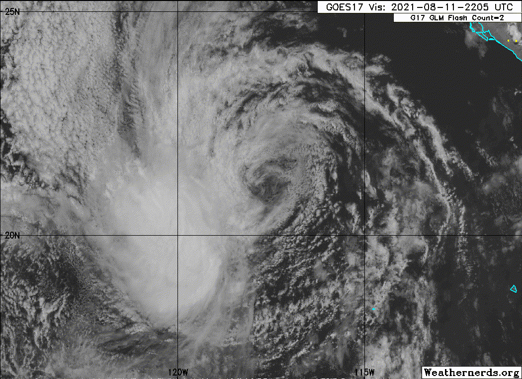
The center of Kevin this evening consists of a broad low-level
swirl, with a decaying area of convection that has become
increasingly detached from the circulation in the southwestern
quadrant. The 0000 UTC subjective Dvorak estimates were both
T2.5/35 kt from SAB and TAFB, while the most recent UW-CIMSS
SATCON estimate was a bit higher at 38 kt. Given the degradation in
convective structure from the previous advisory, the initial
intensity is lowered to 35 kt for this advisory.
After an earlier westward jog, the initial motion has resumed a more
northwest heading at 305/11 kt. The track philosophy remains
unchanged, as Kevin's broad circulation will continue to be steered
to the west-northwest or northwest along the southwestern side of a
deep tropospheric ridge for the next 48-60 hours. The latest track
forecast is essentially an update from the previous advisory, and
lies nearly along the HCCA consensus aid, just a shade west of the
previous forecast track.
As Kevin continues to move into cooler sea-surface temperatures and
a drier air-mass, the storm is expected to continue weakening as the
remaining organized convection ceases. The latest intensity forecast
weakens Kevin to a tropical depression tomorrow morning and
degenerates the cyclone into a remnant low by Friday morning, in
good agreement with the model guidance that shows the remaining
convection dissipating by tomorrow night.
FORECAST POSITIONS AND MAX WINDS
INIT 12/0300Z 22.0N 118.2W 35 KT 40 MPH
12H 12/1200Z 22.9N 119.9W 30 KT 35 MPH
24H 13/0000Z 24.1N 122.3W 30 KT 35 MPH
36H 13/1200Z 25.5N 124.6W 25 KT 30 MPH...POST-TROP/REMNT LOW
48H 14/0000Z 27.1N 126.7W 25 KT 30 MPH...POST-TROP/REMNT LOW
60H 14/1200Z 28.7N 128.2W 20 KT 25 MPH...POST-TROP/REMNT LOW
72H 15/0000Z...DISSIPATED
$$
Forecaster Papin/Stewart
NWS National Hurricane Center Miami FL EP112021
800 PM PDT Wed Aug 11 2021
The center of Kevin this evening consists of a broad low-level
swirl, with a decaying area of convection that has become
increasingly detached from the circulation in the southwestern
quadrant. The 0000 UTC subjective Dvorak estimates were both
T2.5/35 kt from SAB and TAFB, while the most recent UW-CIMSS
SATCON estimate was a bit higher at 38 kt. Given the degradation in
convective structure from the previous advisory, the initial
intensity is lowered to 35 kt for this advisory.
After an earlier westward jog, the initial motion has resumed a more
northwest heading at 305/11 kt. The track philosophy remains
unchanged, as Kevin's broad circulation will continue to be steered
to the west-northwest or northwest along the southwestern side of a
deep tropospheric ridge for the next 48-60 hours. The latest track
forecast is essentially an update from the previous advisory, and
lies nearly along the HCCA consensus aid, just a shade west of the
previous forecast track.
As Kevin continues to move into cooler sea-surface temperatures and
a drier air-mass, the storm is expected to continue weakening as the
remaining organized convection ceases. The latest intensity forecast
weakens Kevin to a tropical depression tomorrow morning and
degenerates the cyclone into a remnant low by Friday morning, in
good agreement with the model guidance that shows the remaining
convection dissipating by tomorrow night.
FORECAST POSITIONS AND MAX WINDS
INIT 12/0300Z 22.0N 118.2W 35 KT 40 MPH
12H 12/1200Z 22.9N 119.9W 30 KT 35 MPH
24H 13/0000Z 24.1N 122.3W 30 KT 35 MPH
36H 13/1200Z 25.5N 124.6W 25 KT 30 MPH...POST-TROP/REMNT LOW
48H 14/0000Z 27.1N 126.7W 25 KT 30 MPH...POST-TROP/REMNT LOW
60H 14/1200Z 28.7N 128.2W 20 KT 25 MPH...POST-TROP/REMNT LOW
72H 15/0000Z...DISSIPATED
$$
Forecaster Papin/Stewart
0 likes
Visit the Caribbean-Central America Weather Thread where you can find at first post web cams,radars
and observations from Caribbean basin members Click Here
and observations from Caribbean basin members Click Here
-
cycloneye
- Admin
- Posts: 139067
- Age: 67
- Joined: Thu Oct 10, 2002 10:54 am
- Location: San Juan, Puerto Rico
Re: EPAC: KEVIN - Tropical Depression
Tropical Depression Kevin Discussion Number 20
NWS National Hurricane Center Miami FL EP112021
200 AM PDT Thu Aug 12 2021
Kevin is barely a tropical cyclone, as its exposed low-level center
has been displaced over 100 n mi northeast of a few small bursts of
convection for most of the night. In fact, the last semblance of
organized convection with this sheared cyclone ended around 11/2100
UTC. If Kevin is unable to generate any organized convection soon,
the system could be declared a post-tropical remnant low later this
morning. Overnight ASCAT-A/B passes only showed 25 to 30-kt winds,
primarily in the eastern semicircle of Kevin. Therefore, the initial
intensity is lowered to 30 kt for this advisory, which makes Kevin a
tropical depression.
Based on recent scatterometer fixes, it appears the broad center of
Kevin is moving slightly more west-northwestward than before, or
295/10 kt. A general west-northwest to northwest motion should
continue through dissipation as the system moves along the
southwestern side of a deep-layer ridge. The track guidance remains
in good agreement, and the official NHC track forecast has been
nudged slightly southward from the previous one based on the initial
motion adjustment.
The cyclone is already north of the 26 deg C isotherm, and it will
move over progressively cooler waters and into a drier, more stable
environment during the next couple of days. Thus, the development of
new, organized convection near Kevin's center seems very unlikely.
The official NHC forecast now shows Kevin degenerating to a remnant
low later today, in agreement with the latest GFS and ECMWF model
simulated satellite imagery. The remnant low should gradually spin
down over the next couple of days before dissipating this weekend.
FORECAST POSITIONS AND MAX WINDS
INIT 12/0900Z 22.3N 119.3W 30 KT 35 MPH
12H 12/1800Z 23.2N 121.0W 25 KT 30 MPH...POST-TROP/REMNT LOW
24H 13/0600Z 24.4N 123.5W 25 KT 30 MPH...POST-TROP/REMNT LOW
36H 13/1800Z 25.8N 125.7W 20 KT 25 MPH...POST-TROP/REMNT LOW
48H 14/0600Z 27.4N 127.6W 20 KT 25 MPH...POST-TROP/REMNT LOW
60H 14/1800Z 29.0N 129.0W 20 KT 25 MPH...POST-TROP/REMNT LOW
72H 15/0600Z...DISSIPATED
$$
Forecaster Reinhart/Cangialosi
0 likes
Visit the Caribbean-Central America Weather Thread where you can find at first post web cams,radars
and observations from Caribbean basin members Click Here
and observations from Caribbean basin members Click Here
-
cycloneye
- Admin
- Posts: 139067
- Age: 67
- Joined: Thu Oct 10, 2002 10:54 am
- Location: San Juan, Puerto Rico
Re: EPAC: KEVIN - Post-Tropical
Post-Tropical Cyclone Kevin Discussion Number 21
NWS National Hurricane Center Miami FL EP112021
800 AM PDT Thu Aug 12 2021
A little bit of convection continues to persist about 200 n mi to
the southwest of Kevin's center, but at that distance, it is not
considered organized in relation to the cyclone. In fact, Kevin has
had this structure for a good 18 hours or so, and it has
therefore degenerated into a remnant low. Based on last evening's
ASCAT passes, it is assumed that winds as high as 30 kt are still
occurring within the circulation. However, the center will be
moving over waters colder than 23 degrees Celsius very soon, so a
gradual decrease in the winds is expected over the next couple of
days. Dissipation of the remnant low in expected in about 3 days.
Kevin is moving toward the west-northwest, or 300/12 kt. The
remnant low is expected to move along the southwestern periphery of
a low- to mid-level ridge centered over the United States and
Mexico, which should cause a west-northwestward or northwestward
motion until dissipation. There is very little spread in the track
guidance, and this last NHC track forecast is just an update of
the previous one.
This is the last advisory being issued for Kevin. For additional
information on the remnant low please see High Seas Forecasts
issued by the National Weather Service under AWIPS header NFDHSFEPI
and WMO header FZPN02 KWBC.
FORECAST POSITIONS AND MAX WINDS
INIT 12/1500Z 23.2N 120.6W 30 KT 35 MPH...POST-TROP/REMNT LOW
12H 13/0000Z 24.2N 122.5W 25 KT 30 MPH...POST-TROP/REMNT LOW
24H 13/1200Z 25.5N 124.9W 25 KT 30 MPH...POST-TROP/REMNT LOW
36H 14/0000Z 27.0N 126.9W 20 KT 25 MPH...POST-TROP/REMNT LOW
48H 14/1200Z 28.7N 128.6W 20 KT 25 MPH...POST-TROP/REMNT LOW
60H 15/0000Z 30.2N 129.8W 20 KT 25 MPH...POST-TROP/REMNT LOW
72H 15/1200Z...DISSIPATED
$$
Forecaster Berg
0 likes
Visit the Caribbean-Central America Weather Thread where you can find at first post web cams,radars
and observations from Caribbean basin members Click Here
and observations from Caribbean basin members Click Here
-
galaxy401

- Category 5
- Posts: 2299
- Age: 28
- Joined: Sat Aug 25, 2012 9:04 pm
- Location: Casa Grande, Arizona
Re: EPAC: KEVIN - Post-Tropical
Time to wait another 6 years for Kevin only for it to be a struggling TS again... 
4 likes
Got my eyes on moving right into Hurricane Alley: Florida.
Who is online
Users browsing this forum: No registered users and 56 guests