WPAC: OMAIS - Post-Tropical

Moderator: S2k Moderators

Message
Author
User avatar
Yellow Evan
Professional-Met
Professional-Met
Posts: 15951
Age: 25
Joined: Fri Jul 15, 2011 12:48 pm
Location: Henderson, Nevada/Honolulu, HI
Contact:

Re: CPAC: INVEST 91C

#21 Postby Yellow Evan » Mon Aug 09, 2021 3:30 pm

000
ACPN50 PHFO 091717
TWOCP

Tropical Weather Outlook
NWS Central Pacific Hurricane Center Honolulu HI
800 AM HST Mon Aug 9 2021

For the central North Pacific...between 140W and 180W:

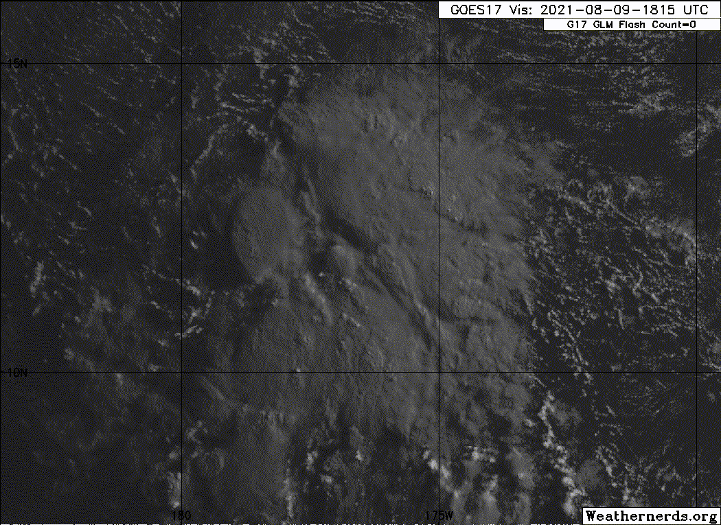
An elongated area of low pressure located around 1400 miles
southwest of Honolulu, Hawaii is producing disorganized showers and
thunderstorms. Environmental conditions should become less favorable
for development as this system moves west-northwest at 10 to 15
mph.
* Formation chance through 48 hours...low...10 percent.
* Formation chance through 5 days...low...10 percent.

Elsewhere, no tropical cyclones are expected during the next 5 days.

$$
Forecaster TS
0 likes   

Sciencerocks
Category 5
Category 5
Posts: 7282
Age: 38
Joined: Thu Jul 06, 2017 1:51 am

Re: CPAC: INVEST 91C

#22 Postby Sciencerocks » Mon Aug 09, 2021 4:43 pm

Image
2 likes   

User avatar
Ubuntwo
Category 5
Category 5
Posts: 1089
Age: 30
Joined: Thu Oct 05, 2017 10:41 pm

Re: CPAC: INVEST 91C

#23 Postby Ubuntwo » Mon Aug 09, 2021 6:44 pm

10% for this is honestly absurd. It's been a while since ASCAT hit but this looks much more organized than Kevin, circulation and all.
Image
10 likes   
Kendall -> SLO -> PBC

Memorable Storms: Katrina (for its Florida landfall...) Wilma Matthew Irma

User avatar
Kingarabian
S2K Supporter
S2K Supporter
Posts: 15432
Joined: Sat Aug 08, 2009 3:06 am
Location: Honolulu, Hawaii

Re: CPAC: INVEST 91C

#24 Postby Kingarabian » Mon Aug 09, 2021 6:47 pm

Ubuntwo wrote:10% for this is honestly absurd. It's been a while since ASCAT hit but this looks much more organized than Kevin, circulation and all.
https://media.discordapp.net/attachments/289981599448039425/874437700776783873/goes17_truecolor_91C_202108091835.gif?width=936&height=676


Yeah unfortunately the CPHC is very conservative. Maybe they''ll raise the odds when it develops a core an an eye becomes apparent.
6 likes   
RIP Kobe Bryant

Chris90
Category 2
Category 2
Posts: 637
Age: 34
Joined: Thu Jun 01, 2017 9:36 pm

Re: CPAC: INVEST 91C

#25 Postby Chris90 » Mon Aug 09, 2021 6:56 pm

This looks good and is probably worthy of classification. It's getting ready to move into the WPAC though so it'll be out of the CPHC area of responsibility very soon.

Also, there's another area that seems to have some spin and convection just to the east of 91C, over there around 167-168W. Central Pacific is managing to be mildly interesting in a down year.
3 likes   
Solar Aquarian
Lunar Cancerian
:uarrow: Sagittarian

User avatar
Yellow Evan
Professional-Met
Professional-Met
Posts: 15951
Age: 25
Joined: Fri Jul 15, 2011 12:48 pm
Location: Henderson, Nevada/Honolulu, HI
Contact:

Re: CPAC: INVEST 91C

#26 Postby Yellow Evan » Mon Aug 09, 2021 7:05 pm

An elongated area of low pressure located around 1500 miles
southwest of Lihue, Hawaii is producing disorganized showers and
thunderstorms. Because this system will be exiting the Central
Pacific shortly, there is little chance of development of in the
Central Pacific basin. Once the system crosses the Date Line, see
the Tropical Weather Advisory issued by the Joint Typhoon Warning
Center for information on development chances in the West Pacific.
* Formation chance through 48 hours...low...near 0 percent.
* Formation chance through 5 days...low...near 0 percent.
0 likes   

User avatar
Yellow Evan
Professional-Met
Professional-Met
Posts: 15951
Age: 25
Joined: Fri Jul 15, 2011 12:48 pm
Location: Henderson, Nevada/Honolulu, HI
Contact:

Re: CPAC: INVEST 91C

#27 Postby Yellow Evan » Mon Aug 09, 2021 7:09 pm

This is a tropical cyclone regardless of what happened the CPHC thinks. Also not sure why SAB hasn’t noticed it.
4 likes   

User avatar
Kingarabian
S2K Supporter
S2K Supporter
Posts: 15432
Joined: Sat Aug 08, 2009 3:06 am
Location: Honolulu, Hawaii

Re: CPAC: INVEST 91C

#28 Postby Kingarabian » Mon Aug 09, 2021 7:11 pm

Yellow Evan wrote:
An elongated area of low pressure located around 1500 miles
southwest of Lihue, Hawaii is producing disorganized showers and
thunderstorms. Because this system will be exiting the Central
Pacific shortly, there is little chance of development of in the
Central Pacific basin. Once the system crosses the Date Line, see
the Tropical Weather Advisory issued by the Joint Typhoon Warning
Center for information on development chances in the West Pacific.
* Formation chance through 48 hours...low...near 0 percent.
* Formation chance through 5 days...low...near 0 percent.


Producing disorganized showers and elongated lol. This should've gotten a CPAC name.
3 likes   
RIP Kobe Bryant

AlphaToOmega
Category 5
Category 5
Posts: 1448
Joined: Sat Jun 26, 2021 10:51 am
Location: Somewhere in Massachusetts

Re: CPAC: INVEST 91C

#29 Postby AlphaToOmega » Mon Aug 09, 2021 7:18 pm

Here is the best track data for Invest 91C
CP, 91, 2021080700, , BEST, 0, 77N, 1670W, 15, 1012, DB, 0, , 0, 0, 0, 0, 1013, 60, 30, 0, 0, C, 0, , 0, 0, INVEST, ,
CP, 91, 2021080706, , BEST, 0, 78N, 1678W, 20, 1011, DB, 0, , 0, 0, 0, 0, 1013, 60, 40, 0, 0, C, 0, , 0, 0, INVEST, ,
CP, 91, 2021080712, , BEST, 0, 80N, 1684W, 20, 1011, DB, 0, , 0, 0, 0, 0, 1013, 60, 40, 0, 0, C, 0, , 0, 0, INVEST, ,
CP, 91, 2021080718, , BEST, 0, 88N, 1688W, 25, 1011, DB, 0, , 0, 0, 0, 0, 1013, 60, 40, 0, 0, C, 0, , 0, 0, INVEST, S,
CP, 91, 2021080800, , BEST, 0, 95N, 1694W, 25, 1011, DB, 0, , 0, 0, 0, 0, 1013, 60, 40, 0, 0, C, 0, , 0, 0, INVEST, S,
CP, 91, 2021080806, , BEST, 0, 99N, 1705W, 20, 1010, DB, 0, , 0, 0, 0, 0, 1012, 50, 30, 0, 0, C, 0, , 0, 0, INVEST, S,
CP, 91, 2021080812, , BEST, 0, 100N, 1719W, 20, 1011, DB, 0, , 0, 0, 0, 0, 1012, 50, 30, 0, 0, C, 0, , 0, 0, INVEST, S,
CP, 91, 2021080818, , BEST, 0, 105N, 1730W, 20, 1011, DB, 0, , 0, 0, 0, 0, 1012, 50, 30, 0, 0, C, 0, , 0, 0, INVEST, ,
CP, 91, 2021080900, , BEST, 0, 110N, 1740W, 20, 1011, DB, 0, , 0, 0, 0, 0, 1012, 50, 30, 0, 0, C, 0, , 0, 0, INVEST, ,
CP, 91, 2021080906, , BEST, 0, 115N, 1751W, 20, 1011, DB, 0, , 0, 0, 0, 0, 1012, 50, 30, 0, 0, C, 0, , 0, 0, INVEST, S,
CP, 91, 2021080912, , BEST, 0, 117N, 1764W, 20, 1011, DB, 34, NEQ, 0, 0, 0, 0, 1012, 50, 30, 0, 0, C, 0, , 0, 0, INVEST, S,


According to this, Invest 91C never exceeded 25 knots in terms of maximum sustained wind speeds, so it probably would have not received a name regardless of whether it were a tropical cyclone or not. There is also post-season analysis.
0 likes   

User avatar
Yellow Evan
Professional-Met
Professional-Met
Posts: 15951
Age: 25
Joined: Fri Jul 15, 2011 12:48 pm
Location: Henderson, Nevada/Honolulu, HI
Contact:

Re: CPAC: INVEST 91C

#30 Postby Yellow Evan » Mon Aug 09, 2021 7:29 pm

CPHC misses systems like this all the time. This is consistent with the track record of being very conservative to upgrade.
7 likes   

User avatar
aspen
Category 5
Category 5
Posts: 8056
Joined: Sat Oct 12, 2019 7:10 pm
Location: Connecticut, USA

Re: CPAC: INVEST 91C

#31 Postby aspen » Mon Aug 09, 2021 7:36 pm

Jeez this has to be the worst miss I’ve ever seen. You can early see the LLC with rather persistent convection, outflow, and banding. What’s next? Giving a Cat 1 with an eye a 40/40 and saying it’s “showing signs of organization”?
6 likes   
Irene '11 Sandy '12 Hermine '16 5/15/2018 Derecho Fay '20 Isaias '20 Elsa '21 Henri '21 Ida '21

I am only a meteorology enthusiast who knows a decent amount about tropical cyclones. Look to the professional mets, the NHC, or your local weather office for the best information.

User avatar
Kingarabian
S2K Supporter
S2K Supporter
Posts: 15432
Joined: Sat Aug 08, 2009 3:06 am
Location: Honolulu, Hawaii

Re: CPAC: INVEST 91C

#32 Postby Kingarabian » Mon Aug 09, 2021 8:07 pm

It would make more sense if they transferred it to the JTWC with 80/90 odds. It's going to look weird when the JTWC instantly puts out a TCFA on what was supposed to be a 0/0 system.
5 likes   
RIP Kobe Bryant

User avatar
Yellow Evan
Professional-Met
Professional-Met
Posts: 15951
Age: 25
Joined: Fri Jul 15, 2011 12:48 pm
Location: Henderson, Nevada/Honolulu, HI
Contact:

Re: CPAC: INVEST 91C

#33 Postby Yellow Evan » Mon Aug 09, 2021 8:12 pm

aspen wrote:Jeez this has to be the worst miss I’ve ever seen. You can early see the LLC with rather persistent convection, outflow, and banding. What’s next? Giving a Cat 1 with an eye a 40/40 and saying it’s “showing signs of organization”?


Not even close to the biggest miss.

Image

This was a tropical cyclone that had just been *named*.
9 likes   

User avatar
aspen
Category 5
Category 5
Posts: 8056
Joined: Sat Oct 12, 2019 7:10 pm
Location: Connecticut, USA

Re: CPAC: INVEST 91C

#34 Postby aspen » Mon Aug 09, 2021 8:15 pm

Yellow Evan wrote:
aspen wrote:Jeez this has to be the worst miss I’ve ever seen. You can early see the LLC with rather persistent convection, outflow, and banding. What’s next? Giving a Cat 1 with an eye a 40/40 and saying it’s “showing signs of organization”?


Not even close to the biggest miss.

https://cdn.discordapp.com/attachments/733552978572869632/869282731069173800/1989052S27233.png

This was a tropical cyclone that had just been *named*.

Only one word can encapsulate the magnitude of this failure:

Bruh

Was that a system that formed in the South Pacific between 180-140W?
5 likes   
Irene '11 Sandy '12 Hermine '16 5/15/2018 Derecho Fay '20 Isaias '20 Elsa '21 Henri '21 Ida '21

I am only a meteorology enthusiast who knows a decent amount about tropical cyclones. Look to the professional mets, the NHC, or your local weather office for the best information.

AlphaToOmega
Category 5
Category 5
Posts: 1448
Joined: Sat Jun 26, 2021 10:51 am
Location: Somewhere in Massachusetts

Re: CPAC: INVEST 91C

#35 Postby AlphaToOmega » Mon Aug 09, 2021 8:23 pm


With that amount of banding, outflow, convection, and a closed low, this would have been named in the East Pacific or the Atlantic.
1 likes   

User avatar
Yellow Evan
Professional-Met
Professional-Met
Posts: 15951
Age: 25
Joined: Fri Jul 15, 2011 12:48 pm
Location: Henderson, Nevada/Honolulu, HI
Contact:

Re: CPAC: INVEST 91C

#36 Postby Yellow Evan » Mon Aug 09, 2021 8:25 pm

aspen wrote:
Yellow Evan wrote:
aspen wrote:Jeez this has to be the worst miss I’ve ever seen. You can early see the LLC with rather persistent convection, outflow, and banding. What’s next? Giving a Cat 1 with an eye a 40/40 and saying it’s “showing signs of organization”?


Not even close to the biggest miss.

https://cdn.discordapp.com/attachments/733552978572869632/869282731069173800/1989052S27233.png

This was a tropical cyclone that had just been *named*.

Only one word can encapsulate the magnitude of this failure:

Bruh

Was that a system that formed in the South Pacific between 180-140W?


https://en.wikipedia.org/wiki/1988%E2%8 ... one_Hinano

No, it actually formed near 130W during the middle of the second strongest La Nina on record.
1 likes   

User avatar
Hayabusa
Category 5
Category 5
Posts: 3736
Joined: Sun Sep 16, 2018 1:05 pm

Re: CPAC: INVEST 91C

#37 Postby Hayabusa » Mon Aug 09, 2021 8:37 pm

It's about to cross to the WPAC, 18Z JMA (analysis from 7 hours ago) is already showing it on their weather maps
WWJP27 RJTD 091800
WARNING AND SUMMARY 091800.
WARNING VALID 101800.
WARNING IS UPDATED EVERY 6 HOURS.
LOW PRESSURE AREA 1012 HPA NEAR 11N 179W WEST 10 KT.


00Z best track it has already crossed
91C.INVEST.20kts.1006mb.12.1N.179.7E

Image
2 likes   
ヤンデレ女が寝取られるているのを見たい!!!
ECMWF ensemble NWPAC plots: https://ecmwfensnwpac.imgbb.com/
Multimodel NWPAC plots: https://multimodelnwpac.imgbb.com/
GFS Ensemble NWPAC plots (16 & 35 day forecast): https://gefsnwpac.imgbb.com/
Plots updated automatically

User avatar
Hayabusa
Category 5
Category 5
Posts: 3736
Joined: Sun Sep 16, 2018 1:05 pm

Re: CPAC: INVEST 91C

#38 Postby Hayabusa » Mon Aug 09, 2021 8:43 pm

Kingarabian wrote:It would make more sense if they transferred it to the JTWC with 80/90 odds. It's going to look weird when the JTWC instantly puts out a TCFA on what was supposed to be a 0/0 system.

yeah and they did :lol:
Image
WTPN21 PGTW 100130
MSGID/GENADMIN/JOINT TYPHOON WRNCEN PEARL HARBOR HI//
SUBJ/TROPICAL CYCLONE FORMATION ALERT (INVEST 91C)//
RMKS/
1. FORMATION OF A SIGNIFICANT TROPICAL CYCLONE IS POSSIBLE WITHIN
130 NM EITHER SIDE OF A LINE FROM 12.0N 179.7W TO 13.3N 174.5E
WITHIN THE NEXT 12 TO 24 HOURS. AVAILABLE DATA DOES NOT JUSTIFY
ISSUANCE OF NUMBERED TROPICAL CYCLONE WARNINGS AT THIS TIME.
WINDS IN THE AREA ARE ESTIMATED TO BE 20 TO 25 KNOTS. METSAT
IMAGERY AT 100100Z INDICATES THAT A CIRCULATION CENTER IS LOCATED
NEAR 12.1N 179.7E. THE SYSTEM IS MOVING WESTWARD AT 14 KNOTS.
2. REMARKS: THE AREA OF CONVECTION (INVEST 91C) IS LOCATED NEAR
12.1N 179.7E, APPROXIMATELY 740NM EAST-NORTHEAST OF KWAJALEIN.
ANIMATED ENHANCED INFRARED (EIR) SATELLITE IMAGERY AND A 091641Z
SSMIS 91GHZ MICROWAVE IMAGE DEPICT DEEP CONVECTION OFFSET TO THE
EASTERN PERIPHERY OF AN EXPOSED, WELL-DEFINED LOW LEVEL CIRCULATION
CENTER (LLCC). ENVIRONMENTAL ANALYSIS INDICATES A FAVORABLE
ENVIRONMENT FOR DEVELOPMENT CHARACTERIZED BY RADIAL OUTFLOW, LOW (10-
15 KT) VERTICAL WIND SHEAR (VWS) AND WARM (28-29C) SEA SURFACE
TEMPERATURE. GLOBAL MODELS GENERALLY AGREE THAT INVEST 91C WILL
TRACK WESTWARD OVER THE NEXT 24 TO 48 HOURS, BUT SPLIT REGARDING
INTENSIFICATION, WITH ECMWF BEING THE MOST AGGRESSIVE AND NAVGEM/GFS
REMAINING BELOW WARNING CRITERIA. MAXIMUM SUSTAINED SURFACE WINDS
ARE ESTIMATED AT 20 TO 25 KNOTS. MINIMUM SEA LEVEL PRESSURE IS
ESTIMATED TO BE NEAR 1006 MB. THE POTENTIAL FOR THE DEVELOPMENT OF A
SIGNIFICANT TROPICAL CYCLONE WITHIN THE NEXT 24 HOURS IS HIGH.
3. THIS ALERT WILL BE REISSUED, UPGRADED TO WARNING OR CANCELLED BY
110130Z.//
NNNN
4 likes   
ヤンデレ女が寝取られるているのを見たい!!!
ECMWF ensemble NWPAC plots: https://ecmwfensnwpac.imgbb.com/
Multimodel NWPAC plots: https://multimodelnwpac.imgbb.com/
GFS Ensemble NWPAC plots (16 & 35 day forecast): https://gefsnwpac.imgbb.com/
Plots updated automatically

User avatar
Hayabusa
Category 5
Category 5
Posts: 3736
Joined: Sun Sep 16, 2018 1:05 pm

Re: WPAC: Tropical Depression 91C

#39 Postby Hayabusa » Tue Aug 10, 2021 3:17 am

WWJP25 RJTD 100600
WARNING AND SUMMARY 100600.
WARNING VALID 110600.
WARNING IS UPDATED EVERY 6 HOURS.
TROPICAL DEPRESSION 1010 HPA AT 12N 180E WEST 10 KT.
0 likes   
ヤンデレ女が寝取られるているのを見たい!!!
ECMWF ensemble NWPAC plots: https://ecmwfensnwpac.imgbb.com/
Multimodel NWPAC plots: https://multimodelnwpac.imgbb.com/
GFS Ensemble NWPAC plots (16 & 35 day forecast): https://gefsnwpac.imgbb.com/
Plots updated automatically

User avatar
InfernoFlameCat
Category 5
Category 5
Posts: 1966
Age: 21
Joined: Mon Dec 14, 2020 10:52 am
Location: Buford, GA

Re: WPAC: Tropical Depression 91C

#40 Postby InfernoFlameCat » Tue Aug 10, 2021 6:54 am

Wow see it’s been upgraded to a TD
0 likes   
I am by no means a professional. DO NOT look at my forecasts for official information or make decisions based on what I post.

Goal: to become a registered expert over tropical and subtropical cyclones.


Return to “2021”

Who is online

Users browsing this forum: No registered users and 18 guests