CPAC: LINDA - Post-Tropical

Moderator: S2k Moderators

Message
Author
User avatar
Kingarabian
S2K Supporter
S2K Supporter
Posts: 15434
Joined: Sat Aug 08, 2009 3:06 am
Location: Honolulu, Hawaii

Re: CPAC: LINDA - Post-Tropical

#521 Postby Kingarabian » Sun Aug 22, 2021 8:29 pm

Yellow Evan wrote:https://twitter.com/derekortt/status/1429603712322965514


This is very likely. Though Linda continues to have a very strong LLC, so popping off strong convection (favoring stronger winds) is still possible all the way until landfall since SST's only get warmer.
3 likes   
RIP Kobe Bryant

User avatar
Kingarabian
S2K Supporter
S2K Supporter
Posts: 15434
Joined: Sat Aug 08, 2009 3:06 am
Location: Honolulu, Hawaii

Re: CPAC: LINDA - Post-Tropical

#522 Postby Kingarabian » Sun Aug 22, 2021 9:04 pm

More hot towers:
Image
0 likes   
RIP Kobe Bryant

Sciencerocks
Category 5
Category 5
Posts: 7286
Age: 38
Joined: Thu Jul 06, 2017 1:51 am

Re: CPAC: LINDA - Post-Tropical

#523 Postby Sciencerocks » Sun Aug 22, 2021 9:21 pm

Image
3 likes   

SconnieCane
Category 4
Category 4
Posts: 913
Joined: Thu Aug 02, 2018 5:29 pm
Location: Madison, WI

Re: CPAC: LINDA - Post-Tropical

#524 Postby SconnieCane » Sun Aug 22, 2021 9:33 pm

That's crazy how it still has the same basic structure it had as an annular hurricane, complete with traces of the eye. It's just that all the convection is gone except for that small burst over the north side. One wonders if a system like this would be capable of re-intensifying very rapidly if it moved into an area of favorable conditions (low shear+warm SSTs).
4 likes   

User avatar
Yellow Evan
Professional-Met
Professional-Met
Posts: 15951
Age: 25
Joined: Fri Jul 15, 2011 12:48 pm
Location: Henderson, Nevada/Honolulu, HI
Contact:

Re: CPAC: LINDA - Post-Tropical

#525 Postby Yellow Evan » Sun Aug 22, 2021 9:38 pm

SconnieCane wrote:That's crazy how it still has the same basic structure it had as an annular hurricane, complete with traces of the eye. It's just that all the convection is gone except for that small burst over the north side. One wonders if a system like this would be capable of re-intensifying very rapidly if it moved into an area of favorable conditions (low shear+warm SSTs).


It’s ULAC is so impressive that it probably would.
1 likes   

User avatar
Kingarabian
S2K Supporter
S2K Supporter
Posts: 15434
Joined: Sat Aug 08, 2009 3:06 am
Location: Honolulu, Hawaii

Re: CPAC: LINDA - Post-Tropical

#526 Postby Kingarabian » Sun Aug 22, 2021 9:39 pm

SconnieCane wrote:That's crazy how it still has the same basic structure it had as an annular hurricane, complete with traces of the eye. It's just that all the convection is gone except for that small burst over the north side. One wonders if a system like this would be capable of re-intensifying very rapidly if it moved into an area of favorable conditions (low shear+warm SSTs).

Yeah it definitely would have. The LLC, the structure, the entire backbone behind Linda is very well defined. Don't see such scenarios very often.
1 likes   
RIP Kobe Bryant

User avatar
Bocadude85
Category 5
Category 5
Posts: 2941
Age: 37
Joined: Mon Apr 18, 2005 2:20 pm
Location: Honolulu,Hi

Re: CPAC: LINDA - Post-Tropical

#527 Postby Bocadude85 » Sun Aug 22, 2021 9:42 pm

Linda looks to be losing a little latitude, which will end up being a bad thing for Oahu.
0 likes   

User avatar
Kingarabian
S2K Supporter
S2K Supporter
Posts: 15434
Joined: Sat Aug 08, 2009 3:06 am
Location: Honolulu, Hawaii

Re: CPAC: LINDA - Post-Tropical

#528 Postby Kingarabian » Sun Aug 22, 2021 9:43 pm

Bocadude85 wrote:Linda looks to be losing a little latitude, which will end up being a bad thing for Oahu.

Sorta wobbling a bit because of the hot towers that keep going off which act to temporarily pull the circulation close to the convection.

Image
0 likes   
RIP Kobe Bryant

User avatar
Kingarabian
S2K Supporter
S2K Supporter
Posts: 15434
Joined: Sat Aug 08, 2009 3:06 am
Location: Honolulu, Hawaii

Re: CPAC: LINDA - Post-Tropical

#529 Postby Kingarabian » Sun Aug 22, 2021 10:13 pm

Possible T2.0/T2.5
Image
0 likes   
RIP Kobe Bryant

User avatar
Kingarabian
S2K Supporter
S2K Supporter
Posts: 15434
Joined: Sat Aug 08, 2009 3:06 am
Location: Honolulu, Hawaii

Re: CPAC: LINDA - Post-Tropical

#530 Postby Kingarabian » Sun Aug 22, 2021 10:17 pm

 https://twitter.com/PlinianWinds/status/1429615645285658625


Cold tops building halfway over the center:
Image
3 likes   
RIP Kobe Bryant

User avatar
Yellow Evan
Professional-Met
Professional-Met
Posts: 15951
Age: 25
Joined: Fri Jul 15, 2011 12:48 pm
Location: Henderson, Nevada/Honolulu, HI
Contact:

Re: CPAC: LINDA - Post-Tropical

#531 Postby Yellow Evan » Sun Aug 22, 2021 11:41 pm

1 likes   

Astromanía
Category 2
Category 2
Posts: 737
Age: 25
Joined: Sat Aug 25, 2018 10:34 pm
Location: Monterrey, N.L, México

Re: CPAC: LINDA - Post-Tropical

#532 Postby Astromanía » Mon Aug 23, 2021 12:24 am

Has ever been a tropical cyclone landfall in Oahu before?
0 likes   

User avatar
Bocadude85
Category 5
Category 5
Posts: 2941
Age: 37
Joined: Mon Apr 18, 2005 2:20 pm
Location: Honolulu,Hi

Re: CPAC: LINDA - Post-Tropical

#533 Postby Bocadude85 » Mon Aug 23, 2021 12:39 am

Astromanía wrote:Has ever been a tropical cyclone landfall in Oahu before?


As far as I know Oahu is the only main Hawaiian island to not have officially recorded a TS or greater landfall.
1 likes   

User avatar
Kingarabian
S2K Supporter
S2K Supporter
Posts: 15434
Joined: Sat Aug 08, 2009 3:06 am
Location: Honolulu, Hawaii

Re: CPAC: LINDA - Post-Tropical

#534 Postby Kingarabian » Mon Aug 23, 2021 12:52 am

Maintaining impressive convection in the face of 30kt shear...
Image

Gotta hope that convection dies down lol so we can get a remnant low landfall as promised.
5 likes   
RIP Kobe Bryant

User avatar
Bocadude85
Category 5
Category 5
Posts: 2941
Age: 37
Joined: Mon Apr 18, 2005 2:20 pm
Location: Honolulu,Hi

Re: CPAC: LINDA - Post-Tropical

#535 Postby Bocadude85 » Mon Aug 23, 2021 12:56 am

Kingarabian wrote:Maintaining impressive convection in the face of 30kt shear...
https://i.imgur.com/DHGVxrd.gif

Gotta hope that convection dies down lol so we can get a remnant low landfall as promised.


We live on Ala Moana Beach..secretly hoping for a little action tomorrow.
0 likes   

User avatar
Kingarabian
S2K Supporter
S2K Supporter
Posts: 15434
Joined: Sat Aug 08, 2009 3:06 am
Location: Honolulu, Hawaii

Re: CPAC: LINDA - Post-Tropical

#536 Postby Kingarabian » Mon Aug 23, 2021 2:23 am

Bocadude85 wrote:
Kingarabian wrote:Maintaining impressive convection in the face of 30kt shear...
https://i.imgur.com/DHGVxrd.gif

Gotta hope that convection dies down lol so we can get a remnant low landfall as promised.


We live on Ala Moana Beach..secretly hoping for a little action tomorrow.


Yeah looks like best track keeps it at 40kt and continues @ 21.0N/154.8W. Looks like the track is there. Not much time to deviate away Oahu. Comes down to how much convection Linda can sustain between now and the next 24 hours.
1 likes   
RIP Kobe Bryant

User avatar
Kingarabian
S2K Supporter
S2K Supporter
Posts: 15434
Joined: Sat Aug 08, 2009 3:06 am
Location: Honolulu, Hawaii

Re: CPAC: LINDA - Post-Tropical

#537 Postby Kingarabian » Mon Aug 23, 2021 2:33 am

Show me a tropical storm without saying its a tropical storm (or however that saying goes):

 https://twitter.com/NWSHonolulu/status/1429704053198557184


4 likes   
RIP Kobe Bryant

User avatar
Kingarabian
S2K Supporter
S2K Supporter
Posts: 15434
Joined: Sat Aug 08, 2009 3:06 am
Location: Honolulu, Hawaii

Re: CPAC: LINDA - Post-Tropical

#538 Postby Kingarabian » Mon Aug 23, 2021 2:51 am

What even is this? First look at the contradiction. Second, look at them sounding the alarm...
Local forecast by
"City, St" or ZIP code
Location Help
News Headlines

Local climate information will move to a new web address on August 26, 2021
NWS is seeking comments on an experimental GIS viewer through October 31, 2021

Honolulu, HI

Weather Forecast Office
Area Forecast Discussion for Hawaii
Weather.gov > Honolulu, HI > Area Forecast Discussion for Hawaii

Current Hazards
Current Conditions
Radar
Forecasts
Rivers and Lakes
Climate and Past Weather
Local Programs

Area Forecast Discussion Issued: 08/22/2021 08:35:31 PM HST


Issued: 8/22/2021, 8:35 PM HST

Synopsis

Expect significant deterioration of the weather situation across most of Hawaii through Monday as a gale low, which is the left over circulation associated with former Tropical Cyclone Linda, churns from east to west across the state. The smaller islands from Maui to Kauai appear to be in direct line to experience the worst impacts of this potent weather system. This includes strong and gusty winds, along with heavy rainfall and thunderstorms that could potentially produce flash flooding. Even the Big Island, which appears to be to the south of the low's track, will likely experience bouts of heavy rain, thunderstorms, and gusty winds.

Discussion

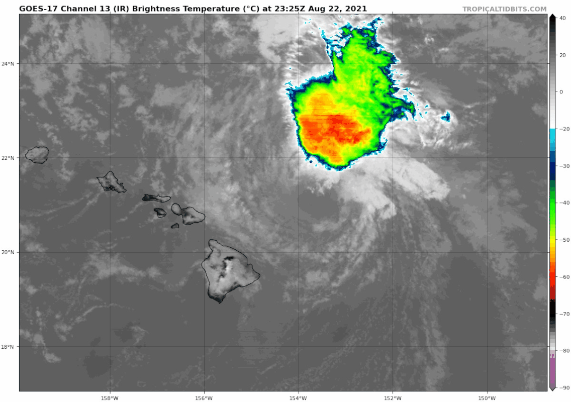
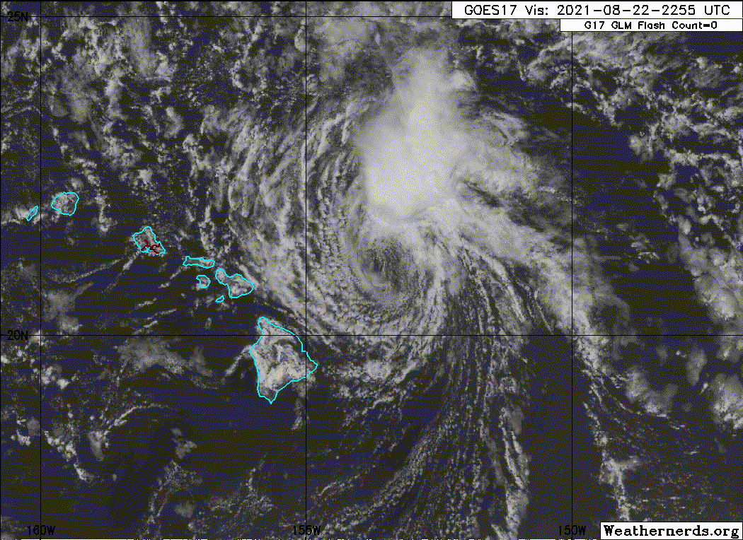
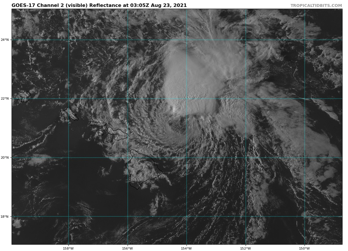
All eyes in the Hawaiian Islands need to focus on an very gloomy forecast that could impact the vast majority of the population, including visitors, during the next 24 to 36 hours. Loops of satellite imagery show the very prominent circulation associated with a gale low that appears to be centered near 21.0N 154.5W, or about 90 miles east of Hana. This low, which has been moving west at about 10 mph, has a large area of thunderstorms with tops in excess of 50 thousand feet to the north of the circulation center. Outer rainbands with heavy rainfall and strong gusty winds are also emanating from this low toward the west and southwest at this time. These rainbands are already impacting the portions of the northern Big Island, Maui, Lanai, and Molokai.

Gale force winds, which are sustained wind speeds of 39 mph or greater, have been observed near these thunderstorms on the north side of the low earlier today. There are likely much stronger wind gusts associated with the heavier rainbands, as well as these thunderstorms. More importantly, since this system has tropical origins, it has likely corralled significant deep moisture within its inner core. As the strong winds and the deep tropical moisture begin to interact with the islands as the night progresses, there will be a serious deterioration in the weather conditions from east to west.

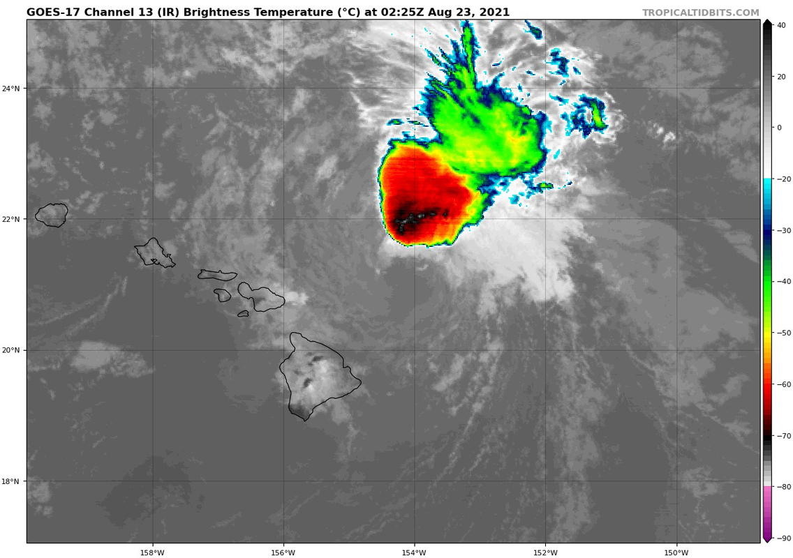
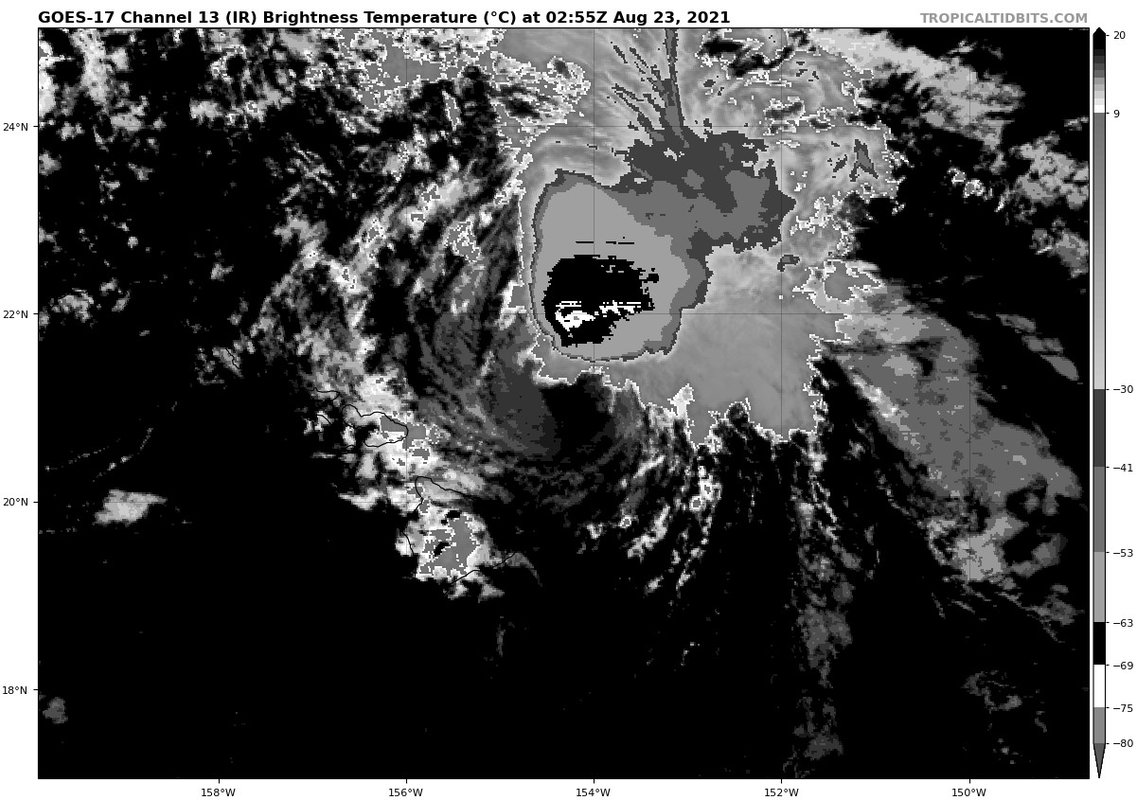
Based on the latest track guidance, we believe the center of the low will be on Maui's doorstep some time after midnight HST. It will continue to bring its heavy rain and gusty winds across the rest of Maui County through early Monday morning. Unfortunately for Oahu, this means that by daybreak Monday, the weather will likely take a serious turn for the worst. Since the track of the low center could be just south of the island, flooding rains with heavy thunderstorms and gusty winds could make the morning commute very challenging. These conditions could persist for several hours, so there could be some issues with tree branches falling, clogged drains, and spotty power outages into Monday afternoon. These adverse weather conditions will also likely spread to Kauai during the daytime hours Monday, where thunderstorms could also produce flash flooding and strong gusty winds.

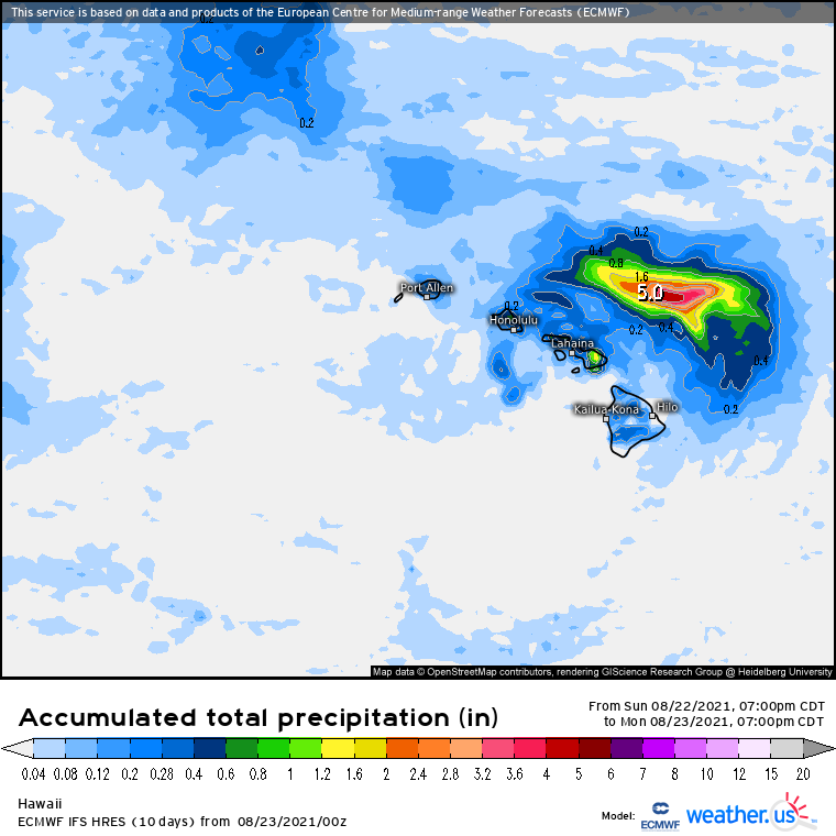
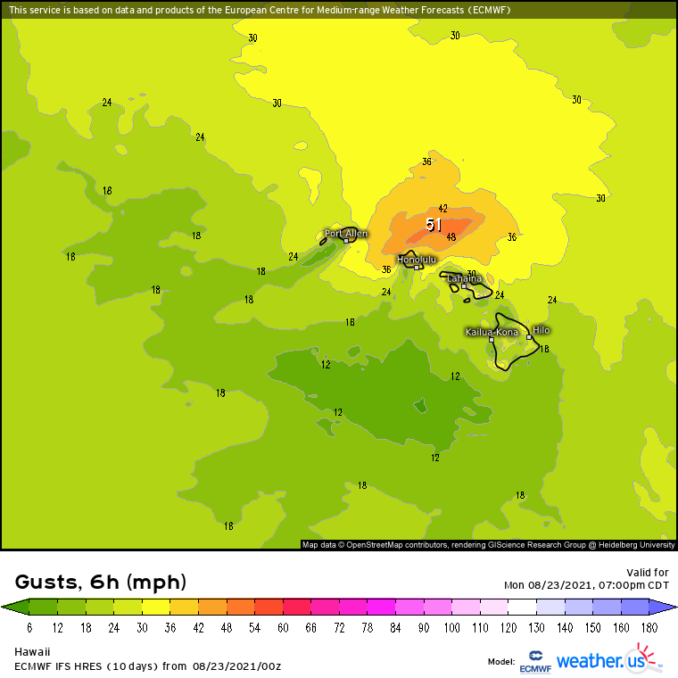
So the bottom line forecast is that the coverage of clouds and the intensity of the showers will increase through Monday, especially over most windward areas. A Flash Flood Watch remains in effect for the entire state through Monday night. A Wind Advisory, which includes wind gusts to 50 mph, has also been issued for all of the smaller islands from Maui to Kauai. The confidence in these strong winds occurring is highest for Oahu and Kauai, which will likely be in the stronger northern semicircle of the westward moving circulation. In addition, the thunderstorms have been in the northern side of the gale low, so this may put Oahu and Kauai in some of the heaviest rainfall. Note that for Maui County, the steadily backing wind profile as the low passes will lead to highly variable conditions with some areas experiencing light or variable winds with intermittent higher wind gusts, especially in thunderstorms.

The expanding windward showers will acquire increasing coverage and depth through early Monday morning, which will bring frequent moderate to locally heavy rainfall. A flash flood threat will exist during this time, but may be relatively modest. As deeper convection and stronger forcing advances over Oahu and Kauai during the day Monday, the potential for torrential rainfall capable of producing flash flooding will increase. This will particularly be the case over windward slopes and the higher terrain. More importantly, the fairly uniform southwesterly flow aloft will give rise to the potential for the deepest convection, including any thunderstorms, to anchor along windward terrain.

Finally, as the gale low center moves to west of each of the individual islands, moist southeast flow spreading up over the islands may produce bands of heavy rain within favored zones of leeward convergence Monday evening. Looking ahead, a more typical trade wind weather will gradually return from Tuesday into mid- week.


Why not just go with a tropical storm warning from the beginning? The public takes those warnings much more seriously. Instead, they're setting up Oahu morning and afternoon traffic to be a huge debacle. Putting the public in danger since very little know that a wind advisory is up and no one knows what a gale system is. People tomorrow will be dealing with "flooding, tree branches falling, clogged drains, and spotty power outages into Monday afternoon" and won't be prepared.

If something serious happens tomorrow on any of the islands, I think the NWS head needs to be contacted and a complaint should be filed against the CPHC . This is clearly a case of "ohhh just leave it, it will go away, the wind shear will get it nothing serious is going to happen" and that clearly is not happening.
Last edited by Kingarabian on Mon Aug 23, 2021 4:41 am, edited 1 time in total.
5 likes   
RIP Kobe Bryant

User avatar
Kingarabian
S2K Supporter
S2K Supporter
Posts: 15434
Joined: Sat Aug 08, 2009 3:06 am
Location: Honolulu, Hawaii

Re: CPAC: LINDA - Post-Tropical

#539 Postby Kingarabian » Mon Aug 23, 2021 3:44 am

CPHC does pretty good with track. You can see why they're concerned since this is what the Euro shows. The Euro track is north of the CPHC and has the center into Molokai/Oahu that would keep the worse north of the islands. If it tracks into Maui as the CPHC shows, then yeah its gonna be a rough 24-36 hours for an unprepared population.

Image
Image
0 likes   
RIP Kobe Bryant

User avatar
Kingarabian
S2K Supporter
S2K Supporter
Posts: 15434
Joined: Sat Aug 08, 2009 3:06 am
Location: Honolulu, Hawaii

Re: CPAC: LINDA - Post-Tropical

#540 Postby Kingarabian » Mon Aug 23, 2021 3:51 am

Former NHC specialist Kimberlain dropping the hammer. :double:

 https://twitter.com/ToddKimberlain/status/1429727523508736004


5 likes   
RIP Kobe Bryant


Return to “2021”

Who is online

Users browsing this forum: No registered users and 56 guests