

NHC 15Z position was within 20 miles of Mexico City with estimated peak wind 70 mph. Mexico City reports peak wind 11 kts. Less than 10 kts as the "center" passed. Mountains are 10,000-13,000 ft high that Grace just moved over. Nothing left but a remnant low at the surface. Mountains tend to do that.
MMMX 211649Z 14011KT 2SM -DZ BKN008 BKN015 OVC070 14/13 A3014 NOSIG RMK 60145 8/77/ HZY
MMMX 211621Z 12008KT 2SM RA BKN008 BKN015 OVC070 14/13 A3013 NOSIG RMK 8/77/ HZY
MMMX 211603Z 11007KT 3SM RA BKN008 BKN015 OVC070 14/12 A3013 NOSIG RMK 8/77/ HZY
MMMX 211542Z 13010KT 7SM -RA BKN008 BKN015 OVC070 14/12 A3012 NOSIG RMK 60065 8/77/ HZY
MMMX 211504Z 20003KT 7SM -RA SCT010 BKN015 OVC070 14/12 A3011 NOSIG RMK 8/77/ HZY
MMMX 211445Z 19004KT 5SM RA FEW010 BKN015 OVC070 14/12 A3011 NOSIG RMK SLP050 54000 991 60145 8/77/ HZY
MMMX 211346Z 25005KT 5SM RA BKN015 OVC070 14/12 A3010 NOSIG RMK 60175 8/52/ LWR VIS W LWR SC NW-N
MMMX 211245Z 27008KT 4SM RA BKN015 OVC070 14/12 A3010 NOSIG RMK 60265 8/52/ LWR VIS 3RD QUAD HZY LWR CLDS ARND
MMMX 211145Z 30010KT 5SM -RA SCT015 OVC070 14/13 A3011 NOSIG RMK SLP037 52003 988 60225 8/57/ HZY
ATL: GRACE - Remnants - Discussion
Moderator: S2k Moderators
Re: ATL: GRACE - Tropical Storm - Discussion
I'm out of the loop on Grace...what was the intensity of the cyclone at landfall?....did the system affect a populated area?....
0 likes
-
cycloneye

- Admin

- Posts: 139059
- Age: 67
- Joined: Thu Oct 10, 2002 10:54 am
- Location: San Juan, Puerto Rico
Re: ATL: GRACE - Tropical Storm - Discussion
underthwx wrote:I'm out of the loop on Grace...what was the intensity of the cyclone at landfall?....did the system affect a populated area?....
The landfall was at 125 mph in area less populated just south of Tuxpan.
0 likes
Visit the Caribbean-Central America Weather Thread where you can find at first post web cams,radars
and observations from Caribbean basin members Click Here
and observations from Caribbean basin members Click Here
-
cycloneye
- Admin
- Posts: 139059
- Age: 67
- Joined: Thu Oct 10, 2002 10:54 am
- Location: San Juan, Puerto Rico
Re: ATL: GRACE - Tropical Storm - Discussion
The Sierra Madre mountains.

9 likes
Visit the Caribbean-Central America Weather Thread where you can find at first post web cams,radars
and observations from Caribbean basin members Click Here
and observations from Caribbean basin members Click Here
-
Astromanía
- Category 2

- Posts: 737
- Age: 25
- Joined: Sat Aug 25, 2018 10:34 pm
- Location: Monterrey, N.L, México
-
Netzero9455
- Tropical Low

- Posts: 19
- Joined: Sun Oct 23, 2016 6:23 pm
Re: ATL: GRACE - Tropical Storm - Discussion
Just to note, this is actually a picture of the mountains in Sierra Madre Occidental, on the Pacific Coast of Mexico, specifically of the Puerto Vallarta area, where the mountains rise to 9,000 feet in around 40 miles from the coast, but start almost immediately at the coast, which of course weakens tropical cyclones extremely fast, think Patricia 2015 where in a few hours it basically disappeared from satellite. In the location where Grace came in, on the Gulf side, the mountains don't start rising until about 60-70 miles from the coast, but rise very rapidly after that, as wxman mentioned, to 13,000 feet in many areas, but immediate landfall location is a coastal plain, meaning that a large area took the full brunt of the storm.
8 likes
-
Astromanía
- Category 2
- Posts: 737
- Age: 25
- Joined: Sat Aug 25, 2018 10:34 pm
- Location: Monterrey, N.L, México
Re: ATL: GRACE - Tropical Storm - Discussion
The mountain range where Grace crossed first was the Sierra Madre Oriental with mountains up to 2000-3000 mts, then it passed to the transversal volcanic belt in central Mexico with mountains up to 5000 mts and as you say there is more plain ground around the gulf compared to the pacific coast in Mexico.
Mexico is mainly dominated by mountains that degrade cyclones fast but the rain is a major problem here
Mexico is mainly dominated by mountains that degrade cyclones fast but the rain is a major problem here
1 likes
-
Sciencerocks
- Category 5

- Posts: 7286
- Age: 38
- Joined: Thu Jul 06, 2017 1:51 am
-
bob rulz
- Category 5
- Posts: 1667
- Age: 34
- Joined: Sat Jan 28, 2006 7:30 pm
- Location: Salt Lake City, Utah
Re: ATL: GRACE - Tropical Storm - Discussion
Josh Morgerman updated - seems like they had a pretty intense ride. Got trapped by fallen trees on their way to their safe destination and had to ride out the back eyewall next to a house.
https://twitter.com/iCyclone/status/1429161049203281923
https://twitter.com/iCyclone/status/1429161049203281923
2 likes
-
Astromanía
- Category 2
- Posts: 737
- Age: 25
- Joined: Sat Aug 25, 2018 10:34 pm
- Location: Monterrey, N.L, México
-
cycloneye
- Admin
- Posts: 139059
- Age: 67
- Joined: Thu Oct 10, 2002 10:54 am
- Location: San Juan, Puerto Rico
Re: ATL: GRACE - Remnants - Discussion
BULLETIN
Remnants Of Grace Advisory Number 34
NWS National Hurricane Center Miami FL AL072021
400 PM CDT Sat Aug 21 2021
...GRACE WEAKENS TO A DISTURBANCE...
...THIS IS THE LAST ADVISORY...
Remnants Of Grace Advisory Number 34
NWS National Hurricane Center Miami FL AL072021
400 PM CDT Sat Aug 21 2021
...GRACE WEAKENS TO A DISTURBANCE...
...THIS IS THE LAST ADVISORY...
0 likes
Visit the Caribbean-Central America Weather Thread where you can find at first post web cams,radars
and observations from Caribbean basin members Click Here
and observations from Caribbean basin members Click Here

Re: ATL: GRACE - Remnants - Discussion
What a rollercoaster of a storm that was. Hopefully the rain and mudslides won’t be too bad. Didn’t someone mention Grace made landfall in an area with a rather low population?
1 likes
Irene '11 Sandy '12 Hermine '16 5/15/2018 Derecho Fay '20 Isaias '20 Elsa '21 Henri '21 Ida '21
I am only a meteorology enthusiast who knows a decent amount about tropical cyclones. Look to the professional mets, the NHC, or your local weather office for the best information.
I am only a meteorology enthusiast who knows a decent amount about tropical cyclones. Look to the professional mets, the NHC, or your local weather office for the best information.
-
toad strangler

- S2K Supporter

- Posts: 4162
- Joined: Sun Jul 28, 2013 3:09 pm
- Location: Earth
- Contact:
Re: ATL: GRACE - Remnants - Discussion
There won’t be any help tightening the NHC cone from this one.
0 likes
Re: ATL: GRACE - Tropical Storm - Discussion
That's a beautiful picture of the Sierra Madre mountains...
0 likes
-
Astromanía
- Category 2
- Posts: 737
- Age: 25
- Joined: Sat Aug 25, 2018 10:34 pm
- Location: Monterrey, N.L, México
Re: ATL: GRACE - Remnants - Discussion
Sadly for now there are 8 confirmed deaths and 3 missing people due to Grace, most of them by mudslides
https://youtu.be/Fw3UA18iNOU
https://youtu.be/Fw3UA18iNOU
0 likes
-
Nancy Smar

- Category 5
- Posts: 1081
- Age: 23
- Joined: Wed Aug 16, 2017 10:03 pm
Re: ATL: GRACE - Remnants - Discussion
WTNT21 PHNC 220100
MSGID/GENADMIN/JOINT TYPHOON WRNCEN PEARL HARBOR HI//
SUBJ/TROPICAL CYCLONE FORMATION ALERT (REMNANTS OF HURRICANE 07L)//
RMKS/
1. FORMATION OF A SIGNIFICANT TROPICAL CYCLONE IS POSSIBLE WITHIN
125 NM EITHER SIDE OF A LINE FROM 19.9N 98.9W TO 20.0N 109.8W
WITHIN THE NEXT 12 TO 24 HOURS. AVAILABLE DATA DOES NOT JUSTIFY
ISSUANCE OF NUMBERED TROPICAL CYCLONE WARNINGS AT THIS TIME.
WINDS IN THE AREA ARE ESTIMATED TO BE 25 TO 30 KNOTS. METSAT
IMAGERY AT 211800Z INDICATES THAT A CIRCULATION CENTER IS LOCATED
NEAR 19.7N 99.5W. THE SYSTEM IS MOVING WESTWARD AT 11 KNOTS.
2. REMARKS: AN AREA OF CONVECTION (REMNANTS OF HURRICANE 07L) HAS
PERSISTED NEAR 19.7N 99.5W, APPROXIMATELY 27 NM SOUTH OF MEXICO
CITY. ANIMATED MULTRISPECTRAL SATELLITE IMAGERY (MSI) DEPICTS A
SUSTAINED LOW LEVEL CIRCULATION CENTER (LLCC) TRACKING OVER MEXICO
WITH DEVELOPING CONVECTION ALONG THE WESTERN PERIPHERY OVER THE
WESTERN SHORELINE. THE SYSTEM IS FORECAST TO TRACK WESTWARD OVER
WARM (29-30C) SEA SURFACE TEMPERATURES (SST). GLOBAL MODELS INDICATE
THE REMNANTS OF HURRICANE 07L WILL BRIEFLY CONSOLIDATE AS IT TRACKS
WEST-NORTHWESTWARD OVER THE PACIFIC. MAXIMUM SUSTAINED SURFACE WINDS
ARE ESTIMATED AT 25 TO 30 KNOTS. MINIMUM SEA LEVEL PRESSURE IS
ESTIMATED TO BE NEAR 998 MB. THE POTENTIAL FOR THE DEVELOPMENT OF A
SIGNIFICANT TROPICAL CYCLONE WITHIN THE NEXT 24 HOURS IS HIGH.
3. THIS ALERT WILL BE REISSUED, UPGRADED TO WARNING OR CANCELLED BY
230100Z.//
0 likes
-
Category5Kaiju

- Category 5
- Posts: 3355
- Age: 22
- Joined: Thu Dec 24, 2020 12:45 pm
- Location: Seattle
Re: ATL: GRACE - Remnants - Discussion
It will probably happen someday, but it is interesting that we have yet to see a recorded Cat 4 or 5 hurricane in the BoC despite it being one of the most consistently favorable parts of the Atlantic for RI and powerful, compact cyclones.
1 likes
Unless explicitly stated, all information covered in my posts is based on my opinions and observations. Please refer to a professional meteorologist or an accredited weather research agency otherwise, especially if serious decisions must be made in the event of a potentially life-threatening tropical storm or hurricane.

Re: ATL: GRACE - Remnants - Discussion
aspen wrote:What a rollercoaster of a storm that was. Hopefully the rain and mudslides won’t be too bad. Didn’t someone mention Grace made landfall in an area with a rather low population?
Tuxpan had a population of over 100,000 but all the cell phone and internet links were likely down after a Cat 3.
At least they are ready for Henri in Watch Hills this afternoon.
https://www.youtube.com/watch?v=2s5xdY6MCeI
0 likes
-
cycloneye
- Admin
- Posts: 139059
- Age: 67
- Joined: Thu Oct 10, 2002 10:54 am
- Location: San Juan, Puerto Rico
Re: ATL: GRACE - Remnants - Discussion
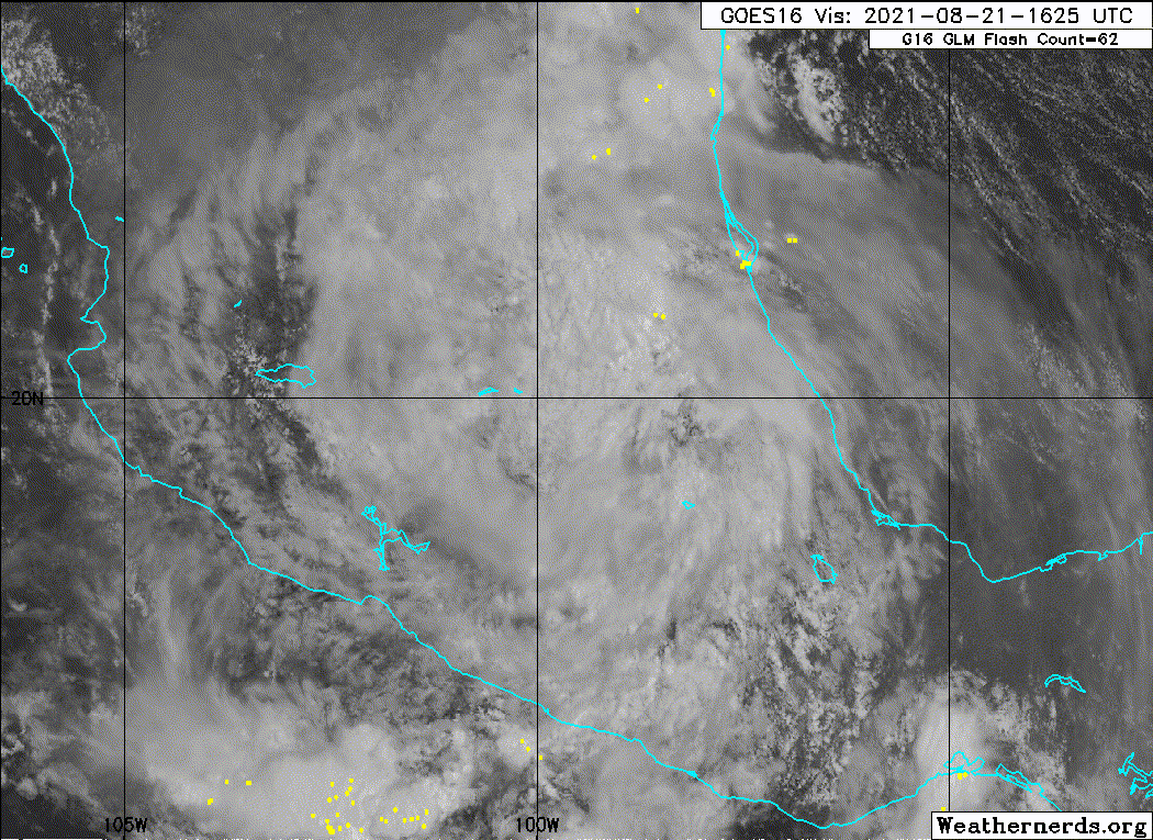
Image of some of the Sierra Madre mountains on the eastern side.

7 likes
Visit the Caribbean-Central America Weather Thread where you can find at first post web cams,radars
and observations from Caribbean basin members Click Here
and observations from Caribbean basin members Click Here
-
Astromanía
- Category 2
- Posts: 737
- Age: 25
- Joined: Sat Aug 25, 2018 10:34 pm
- Location: Monterrey, N.L, México
Re: ATL: GRACE - Remnants - Discussion
2 likes
Who is online
Users browsing this forum: No registered users and 60 guests