EPAC: MARTY - Remnants
Moderator: S2k Moderators
-
Sciencerocks
- Category 5

- Posts: 7282
- Age: 38
- Joined: Thu Jul 06, 2017 1:51 am
-
cycloneye

- Admin

- Posts: 139008
- Age: 67
- Joined: Thu Oct 10, 2002 10:54 am
- Location: San Juan, Puerto Rico
Re: EPAC: MARTY - Remnants
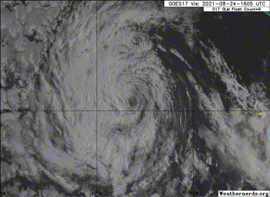
Post-Tropical Cyclone Marty Discussion Number 7
NWS National Hurricane Center Miami FL EP132021
200 PM PDT Tue Aug 24 2021
There has been no significant deep convection within 100 nmi of
Marty's center for more than 12 hours. As a result, Marty has
degenerated into a remnant low. The initial intensity has been
maintained at 30 kt based on ASCAT-B/-A passes between 1700-1800
UTC that still showed a significant fetch of 25-kt winds over much
of the northern quadrant, including a few embedded 28-kt vectors.
Since Marty is forecast to remain over sub-26C sea-surface
temperatures and within a large field of cold-air stratocumulus
clouds, gradual spin down of the vortex and weakening of the
cyclone's peak winds are expected until dissipation occurs in about
72 hours. The new NHC intensity forecast is similar to the previous
advisory, and closely follows a blend of the IVCN and NOAA-HCCA
intensity consensus models.
The initial motion estimate remains westward, or 270/10 kt. For
the next 36 hours or so, the remnant low is forecast to move
westward along the southern periphery of a sprawling deep-layer
ridge located northwest through northeast of Marty. Thereafter, a
motion toward the west-southwest is expected until the cyclone
dissipates. The new NHC forecast track is essentially just an
extension of the previous advisory track, and lies down the middle
of the tightly packed consensus models, which have shifted a little
to the south on this forecast cycle.
This is the last advisory being issued on Marty. For additional
information on the remnant low, please see High Seas Forecasts
issued by the National Weather Service under AWIPS header NFDHSFEPI
and WMO header FZPN02 KWBC.
FORECAST POSITIONS AND MAX WINDS
INIT 24/2100Z 20.5N 119.2W 30 KT 35 MPH...POST-TROP/REMNT LOW
12H 25/0600Z 20.5N 120.8W 25 KT 30 MPH...POST-TROP/REMNT LOW
24H 25/1800Z 20.5N 122.9W 25 KT 30 MPH...POST-TROP/REMNT LOW
36H 26/0600Z 20.4N 125.0W 20 KT 25 MPH...POST-TROP/REMNT LOW
48H 26/1800Z 20.2N 127.2W 20 KT 25 MPH...POST-TROP/REMNT LOW
60H 27/0600Z 19.8N 129.6W 20 KT 25 MPH...POST-TROP/REMNT LOW
72H 27/1800Z...DISSIPATED
$$
Forecaster Stewart
0 likes
Visit the Caribbean-Central America Weather Thread where you can find at first post web cams,radars
and observations from Caribbean basin members Click Here
and observations from Caribbean basin members Click Here
-
somethingfunny

- ChatStaff

- Posts: 3926
- Age: 35
- Joined: Thu May 31, 2007 10:30 pm
- Location: McKinney, Texas
Re: EPAC: MARTY - Remnants
Bye Grace! 
2 likes
I am not a meteorologist, and any posts made by me are not official forecasts or to be interpreted as being intelligent. These posts are just my opinions and are probably silly opinions.
-
Hypercane_Kyle

- Category 5
- Posts: 2899
- Joined: Sat Mar 07, 2015 7:58 pm
- Location: Cape Canaveral, FL
Re: EPAC: MARTY - Remnants
See ya, Grace.

1 likes
My posts are my own personal opinion, defer to the National Hurricane Center (NHC) and other NOAA products for decision making during hurricane season.
Who is online
Users browsing this forum: No registered users and 7 guests