EPAC: MARTY - Remnants
Moderator: S2k Moderators
-
Sciencerocks
- Category 5

- Posts: 7282
- Age: 38
- Joined: Thu Jul 06, 2017 1:51 am
-
Yellow Evan

- Professional-Met

- Posts: 15951
- Age: 25
- Joined: Fri Jul 15, 2011 12:48 pm
- Location: Henderson, Nevada/Honolulu, HI
- Contact:

-
Kingarabian

- S2K Supporter

- Posts: 15434
- Joined: Sat Aug 08, 2009 3:06 am
- Location: Honolulu, Hawaii
Re: EPAC: MARTY - Tropical Storm
Sciencerocks wrote:[url]https://imagizer.imageshack.com/img922/1860/CazGSx.gif[url]
Clear easterly shear.
0 likes
RIP Kobe Bryant
-
Sciencerocks
- Category 5
- Posts: 7282
- Age: 38
- Joined: Thu Jul 06, 2017 1:51 am
-
cycloneye

- Admin

- Posts: 139046
- Age: 67
- Joined: Thu Oct 10, 2002 10:54 am
- Location: San Juan, Puerto Rico
Re: EPAC: MARTY - Tropical Storm
Tropical Storm Marty Discussion Number 3
NWS National Hurricane Center Miami FL EP132021
300 PM MDT Mon Aug 23 2021
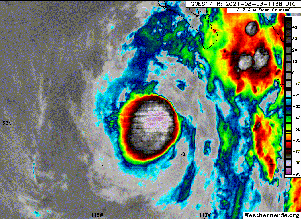
Marty remains a sheared tropical cyclone due to northeasterly
vertical wind shear of about 10 kt as assessed by the GFS and ECMWF
models, which seems underdone given the pronounced erosion of the
deep convection since the previous advisory. Having said that, Marty
has still managed to strengthen a little to 40 kt, which is based on
a 1521Z ASCAT-A pass that contained one 39-kt surface wind vector
embedded within a large field of 35-37-kt wind vectors located over
most of the northwest quadrant of the cyclone's circulation.
The initial motion estimate remains a little north of due westward,
or 280/13 kt. There are no significant changes to the previous
track forecast or synoptic reasoning. A strong ridge to the north of
Marty is expected to remain dominant across the eastern Pacific
basin, which should act to keep the cyclone moving on a general
westward track for the next 48 hours. Thereafter, the ridge is
forecast by the global and regional models to build slightly
southward, which should force a weakening Marty in a
west-southwestward direction. The new NHC track forecast is similar
to but a little north, or right, of the previous advisory track, and
lies along the southern edge of tightly packed consensus track
models, which have once again shifted slightly northward.
Although global model diagnostics indicate that the northeasterly
shear has abated to about 10 kt, one would never guess that by
looking at the visible and infrared satellite trends over the past
few hours, which show a noticeable erosion of the overall convective
pattern. Although the convection should re-develop some overnight
during the convective maximum period, it is unlikely that Marty will
strengthen due to the entrainment of nearby low-level stable
stratocumulus clouds that will act to reduce the amount of available
instability. The latest model runs continue to forecast the
deep-layer shear to weaken a little more and remain low through the
remainder of the forecast period. However, Marty will be moving over
sub-26C SSTs and into a drier and more stable airmass by 24 hours,
and those unfavorable environmental conditions should work to offset
the favorable shear conditions, resulting in slow but steady
weakening in the 24-96-h period. Marty is forecast to become a
depression by Tuesday night or Wednesday, degenerate into a remnant
low by Thursday, and dissipate on Friday. The official intensity
forecast is essentially just an update of the previous NHC forecast,
and closely follows the simple- and corrected consensus models IVCN,
NOAA-HCCA, and FSSE.
FORECAST POSITIONS AND MAX WINDS
INIT 23/2100Z 20.9N 114.1W 40 KT 45 MPH
12H 24/0600Z 21.0N 116.2W 40 KT 45 MPH
24H 24/1800Z 21.0N 118.6W 35 KT 40 MPH
36H 25/0600Z 21.0N 120.6W 30 KT 35 MPH
48H 25/1800Z 20.9N 122.6W 30 KT 35 MPH...POST-TROP/REMNT LOW
60H 26/0600Z 20.9N 124.8W 25 KT 30 MPH...POST-TROP/REMNT LOW
72H 26/1800Z 20.8N 127.0W 20 KT 25 MPH...POST-TROP/REMNT LOW
96H 27/1800Z 19.4N 131.9W 20 KT 25 MPH...POST-TROP/REMNT LOW
120H 28/1800Z...DISSIPATED
$$
Forecaster Stewart
NWS National Hurricane Center Miami FL EP132021
300 PM MDT Mon Aug 23 2021
Marty remains a sheared tropical cyclone due to northeasterly
vertical wind shear of about 10 kt as assessed by the GFS and ECMWF
models, which seems underdone given the pronounced erosion of the
deep convection since the previous advisory. Having said that, Marty
has still managed to strengthen a little to 40 kt, which is based on
a 1521Z ASCAT-A pass that contained one 39-kt surface wind vector
embedded within a large field of 35-37-kt wind vectors located over
most of the northwest quadrant of the cyclone's circulation.
The initial motion estimate remains a little north of due westward,
or 280/13 kt. There are no significant changes to the previous
track forecast or synoptic reasoning. A strong ridge to the north of
Marty is expected to remain dominant across the eastern Pacific
basin, which should act to keep the cyclone moving on a general
westward track for the next 48 hours. Thereafter, the ridge is
forecast by the global and regional models to build slightly
southward, which should force a weakening Marty in a
west-southwestward direction. The new NHC track forecast is similar
to but a little north, or right, of the previous advisory track, and
lies along the southern edge of tightly packed consensus track
models, which have once again shifted slightly northward.
Although global model diagnostics indicate that the northeasterly
shear has abated to about 10 kt, one would never guess that by
looking at the visible and infrared satellite trends over the past
few hours, which show a noticeable erosion of the overall convective
pattern. Although the convection should re-develop some overnight
during the convective maximum period, it is unlikely that Marty will
strengthen due to the entrainment of nearby low-level stable
stratocumulus clouds that will act to reduce the amount of available
instability. The latest model runs continue to forecast the
deep-layer shear to weaken a little more and remain low through the
remainder of the forecast period. However, Marty will be moving over
sub-26C SSTs and into a drier and more stable airmass by 24 hours,
and those unfavorable environmental conditions should work to offset
the favorable shear conditions, resulting in slow but steady
weakening in the 24-96-h period. Marty is forecast to become a
depression by Tuesday night or Wednesday, degenerate into a remnant
low by Thursday, and dissipate on Friday. The official intensity
forecast is essentially just an update of the previous NHC forecast,
and closely follows the simple- and corrected consensus models IVCN,
NOAA-HCCA, and FSSE.
FORECAST POSITIONS AND MAX WINDS
INIT 23/2100Z 20.9N 114.1W 40 KT 45 MPH
12H 24/0600Z 21.0N 116.2W 40 KT 45 MPH
24H 24/1800Z 21.0N 118.6W 35 KT 40 MPH
36H 25/0600Z 21.0N 120.6W 30 KT 35 MPH
48H 25/1800Z 20.9N 122.6W 30 KT 35 MPH...POST-TROP/REMNT LOW
60H 26/0600Z 20.9N 124.8W 25 KT 30 MPH...POST-TROP/REMNT LOW
72H 26/1800Z 20.8N 127.0W 20 KT 25 MPH...POST-TROP/REMNT LOW
96H 27/1800Z 19.4N 131.9W 20 KT 25 MPH...POST-TROP/REMNT LOW
120H 28/1800Z...DISSIPATED
$$
Forecaster Stewart
0 likes
Visit the Caribbean-Central America Weather Thread where you can find at first post web cams,radars
and observations from Caribbean basin members Click Here
and observations from Caribbean basin members Click Here
-
Kingarabian
- S2K Supporter
- Posts: 15434
- Joined: Sat Aug 08, 2009 3:06 am
- Location: Honolulu, Hawaii
Re: EPAC: MARTY - Tropical Storm
Sciencerocks wrote:[url]https://imagizer.imageshack.com/img924/6379/YOtdpH.gif[url]
Lol they all look and get sheared alike.
0 likes
RIP Kobe Bryant
-
Yellow Evan
- Professional-Met
- Posts: 15951
- Age: 25
- Joined: Fri Jul 15, 2011 12:48 pm
- Location: Henderson, Nevada/Honolulu, HI
- Contact:
-
Sciencerocks
- Category 5
- Posts: 7282
- Age: 38
- Joined: Thu Jul 06, 2017 1:51 am
-
Yellow Evan
- Professional-Met
- Posts: 15951
- Age: 25
- Joined: Fri Jul 15, 2011 12:48 pm
- Location: Henderson, Nevada/Honolulu, HI
- Contact:
Re: EPAC: MARTY - Tropical Storm
817
WTPZ43 KNHC 240236
TCDEP3
Tropical Storm Marty Discussion Number 4
NWS National Hurricane Center Miami FL EP132021
800 PM PDT Mon Aug 23 2021
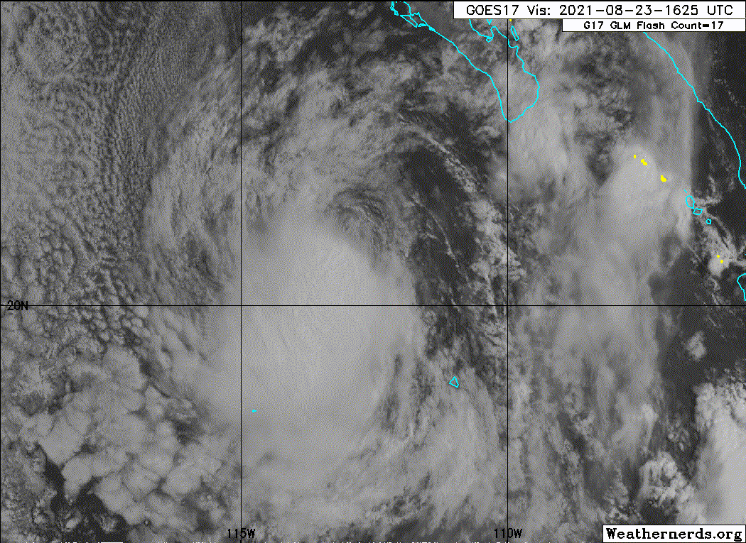
Northeasterly vertical wind shear continues to disrupt the
organization of Marty. The limited shower activity associated with
the cyclone remains displaced to the southwest of its exposed
low-level center. Despite its poor satellite appearance for much of
the day, earlier scatterometer data showed 35 to 40-kt winds in the
sheared cyclone. The latest objective satellite estimates and
subjective Dvorak classifications support an intensity of 35 kt.
However, the initial intensity for this advisory is conservatively
held at 40 kt, with hopes that new scatterometer data become
available overnight to better reassess Marty's intensity.
Marty is moving westward, or 270/15 kt. The subtropical ridge to the
north of Marty will continue to steer the cyclone generally westward
over the next couple days. Then, the weakening cyclone is forecast
to turn west-southwestward during the latter part of the week within
the low-level trade wind flow. The latest NHC track forecast is
adjusted just a bit south of the previous one, near the middle of
the guidance envelope and close to the multi-model consensus aids.
Despite the modest wind shear values diagnosed from the SHIPS
guidance, Marty is clearly struggling to maintain organized
convection. Furthermore, Marty only has a brief window over
sufficiently warm SSTs before it crosses the 26 deg C isotherm on
Tuesday and moves into a drier, more stable airmass. Therefore,
gradual weakening is expected to begin on Tuesday and continue
through the rest of the week. In fact, the latest global model
simulated satellite imagery suggests Marty could struggle to
generate any organized convection beyond tonight's convective
maximum period. The latest NHC intensity forecast is essentially
unchanged. Marty is forecast to weaken to a depression by early
Wednesday, degenerate into a remnant low by Wednesday night, and
dissipate late this week. But, it is possible these changes could
occur even sooner than forecast if Marty's convective structure does
not improve soon.
FORECAST POSITIONS AND MAX WINDS
INIT 24/0300Z 20.7N 115.8W 40 KT 45 MPH
12H 24/1200Z 20.7N 117.8W 35 KT 40 MPH
24H 25/0000Z 20.7N 119.9W 35 KT 40 MPH
36H 25/1200Z 20.7N 121.8W 30 KT 35 MPH
48H 26/0000Z 20.7N 123.9W 25 KT 30 MPH...POST-TROP/REMNT LOW
60H 26/1200Z 20.5N 126.0W 25 KT 30 MPH...POST-TROP/REMNT LOW
72H 27/0000Z 20.1N 128.5W 20 KT 25 MPH...POST-TROP/REMNT LOW
96H 28/0000Z 18.7N 133.1W 20 KT 25 MPH...POST-TROP/REMNT LOW
120H 29/0000Z...DISSIPATED
$$
Forecaster Reinhart/Pasch
WTPZ43 KNHC 240236
TCDEP3
Tropical Storm Marty Discussion Number 4
NWS National Hurricane Center Miami FL EP132021
800 PM PDT Mon Aug 23 2021
Northeasterly vertical wind shear continues to disrupt the
organization of Marty. The limited shower activity associated with
the cyclone remains displaced to the southwest of its exposed
low-level center. Despite its poor satellite appearance for much of
the day, earlier scatterometer data showed 35 to 40-kt winds in the
sheared cyclone. The latest objective satellite estimates and
subjective Dvorak classifications support an intensity of 35 kt.
However, the initial intensity for this advisory is conservatively
held at 40 kt, with hopes that new scatterometer data become
available overnight to better reassess Marty's intensity.
Marty is moving westward, or 270/15 kt. The subtropical ridge to the
north of Marty will continue to steer the cyclone generally westward
over the next couple days. Then, the weakening cyclone is forecast
to turn west-southwestward during the latter part of the week within
the low-level trade wind flow. The latest NHC track forecast is
adjusted just a bit south of the previous one, near the middle of
the guidance envelope and close to the multi-model consensus aids.
Despite the modest wind shear values diagnosed from the SHIPS
guidance, Marty is clearly struggling to maintain organized
convection. Furthermore, Marty only has a brief window over
sufficiently warm SSTs before it crosses the 26 deg C isotherm on
Tuesday and moves into a drier, more stable airmass. Therefore,
gradual weakening is expected to begin on Tuesday and continue
through the rest of the week. In fact, the latest global model
simulated satellite imagery suggests Marty could struggle to
generate any organized convection beyond tonight's convective
maximum period. The latest NHC intensity forecast is essentially
unchanged. Marty is forecast to weaken to a depression by early
Wednesday, degenerate into a remnant low by Wednesday night, and
dissipate late this week. But, it is possible these changes could
occur even sooner than forecast if Marty's convective structure does
not improve soon.
FORECAST POSITIONS AND MAX WINDS
INIT 24/0300Z 20.7N 115.8W 40 KT 45 MPH
12H 24/1200Z 20.7N 117.8W 35 KT 40 MPH
24H 25/0000Z 20.7N 119.9W 35 KT 40 MPH
36H 25/1200Z 20.7N 121.8W 30 KT 35 MPH
48H 26/0000Z 20.7N 123.9W 25 KT 30 MPH...POST-TROP/REMNT LOW
60H 26/1200Z 20.5N 126.0W 25 KT 30 MPH...POST-TROP/REMNT LOW
72H 27/0000Z 20.1N 128.5W 20 KT 25 MPH...POST-TROP/REMNT LOW
96H 28/0000Z 18.7N 133.1W 20 KT 25 MPH...POST-TROP/REMNT LOW
120H 29/0000Z...DISSIPATED
$$
Forecaster Reinhart/Pasch
0 likes
-
Sciencerocks
- Category 5
- Posts: 7282
- Age: 38
- Joined: Thu Jul 06, 2017 1:51 am
-
Yellow Evan
- Professional-Met
- Posts: 15951
- Age: 25
- Joined: Fri Jul 15, 2011 12:48 pm
- Location: Henderson, Nevada/Honolulu, HI
- Contact:
Re: EPAC: MARTY - Tropical Storm
811
WTPZ43 KNHC 240838
TCDEP3
Tropical Storm Marty Discussion Number 5
NWS National Hurricane Center Miami FL EP132021
200 AM PDT Tue Aug 24 2021
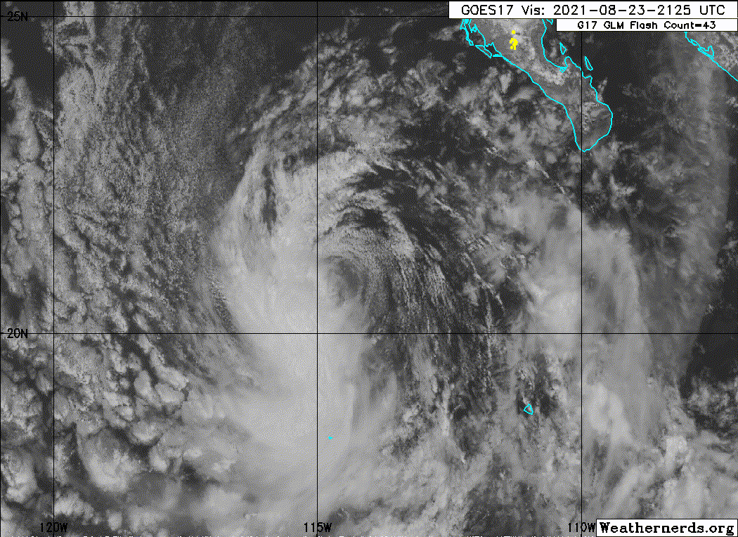
Satellite imagery indicates that Marty is currently a swirl of
low-level clouds with no associated convection, with this likely due
to a combination of northeasterly vertical shear and marginal sea
surface temperatures. Recent ASCAT data shows maximum winds of
30-35 kt over a small area in the northern semicircle, so the
initial intensity is reduced to 35 kt.
The initial motion is still westward, but slower than before, at
270/11 kt. The subtropical ridge to the north of Marty will
continue to steer the cyclone generally westward over the next day
or two. After that, the weakening cyclone is expected to turn west-
southwestward during the latter part of the week within the
low-level trade wind flow. The new forecast track is similar to,
but a little slower than the previous forecast, and it lies near the
various consensus models.
Although the current shear is forecast to diminish, a combination of
decreasing sea surface temperatures and a dryer air mass along the
forecast track should cause continued gradual weakening. The new
intensity forecast shows the system weakening to a depression in
about 24 h and degenerating to a remnant low by 48 h. If convection
does not re-develop near the center, both of these events could
occur earlier than forecast.
FORECAST POSITIONS AND MAX WINDS
INIT 24/0900Z 20.6N 117.0W 35 KT 40 MPH
12H 24/1800Z 20.6N 118.7W 35 KT 40 MPH
24H 25/0600Z 20.6N 120.9W 30 KT 35 MPH
36H 25/1800Z 20.7N 122.8W 25 KT 30 MPH
48H 26/0600Z 20.6N 124.8W 25 KT 30 MPH...POST-TROP/REMNT LOW
60H 26/1800Z 20.4N 127.0W 25 KT 30 MPH...POST-TROP/REMNT LOW
72H 27/0600Z 19.8N 129.5W 20 KT 25 MPH...POST-TROP/REMNT LOW
96H 28/0600Z 18.5N 134.5W 20 KT 25 MPH...POST-TROP/REMNT LOW
120H 29/0600Z...DISSIPATED
$$
Forecaster Beven
WTPZ43 KNHC 240838
TCDEP3
Tropical Storm Marty Discussion Number 5
NWS National Hurricane Center Miami FL EP132021
200 AM PDT Tue Aug 24 2021
Satellite imagery indicates that Marty is currently a swirl of
low-level clouds with no associated convection, with this likely due
to a combination of northeasterly vertical shear and marginal sea
surface temperatures. Recent ASCAT data shows maximum winds of
30-35 kt over a small area in the northern semicircle, so the
initial intensity is reduced to 35 kt.
The initial motion is still westward, but slower than before, at
270/11 kt. The subtropical ridge to the north of Marty will
continue to steer the cyclone generally westward over the next day
or two. After that, the weakening cyclone is expected to turn west-
southwestward during the latter part of the week within the
low-level trade wind flow. The new forecast track is similar to,
but a little slower than the previous forecast, and it lies near the
various consensus models.
Although the current shear is forecast to diminish, a combination of
decreasing sea surface temperatures and a dryer air mass along the
forecast track should cause continued gradual weakening. The new
intensity forecast shows the system weakening to a depression in
about 24 h and degenerating to a remnant low by 48 h. If convection
does not re-develop near the center, both of these events could
occur earlier than forecast.
FORECAST POSITIONS AND MAX WINDS
INIT 24/0900Z 20.6N 117.0W 35 KT 40 MPH
12H 24/1800Z 20.6N 118.7W 35 KT 40 MPH
24H 25/0600Z 20.6N 120.9W 30 KT 35 MPH
36H 25/1800Z 20.7N 122.8W 25 KT 30 MPH
48H 26/0600Z 20.6N 124.8W 25 KT 30 MPH...POST-TROP/REMNT LOW
60H 26/1800Z 20.4N 127.0W 25 KT 30 MPH...POST-TROP/REMNT LOW
72H 27/0600Z 19.8N 129.5W 20 KT 25 MPH...POST-TROP/REMNT LOW
96H 28/0600Z 18.5N 134.5W 20 KT 25 MPH...POST-TROP/REMNT LOW
120H 29/0600Z...DISSIPATED
$$
Forecaster Beven
0 likes
-
AlphaToOmega
- Category 5
- Posts: 1448
- Joined: Sat Jun 26, 2021 10:51 am
- Location: Somewhere in Massachusetts
-
Astromanía
- Category 2

- Posts: 737
- Age: 25
- Joined: Sat Aug 25, 2018 10:34 pm
- Location: Monterrey, N.L, México
-
AnnularCane

- S2K Supporter
- Posts: 2634
- Joined: Thu Jun 08, 2006 9:18 am
- Location: Wytheville, VA
Re: EPAC: MARTY - Tropical Storm
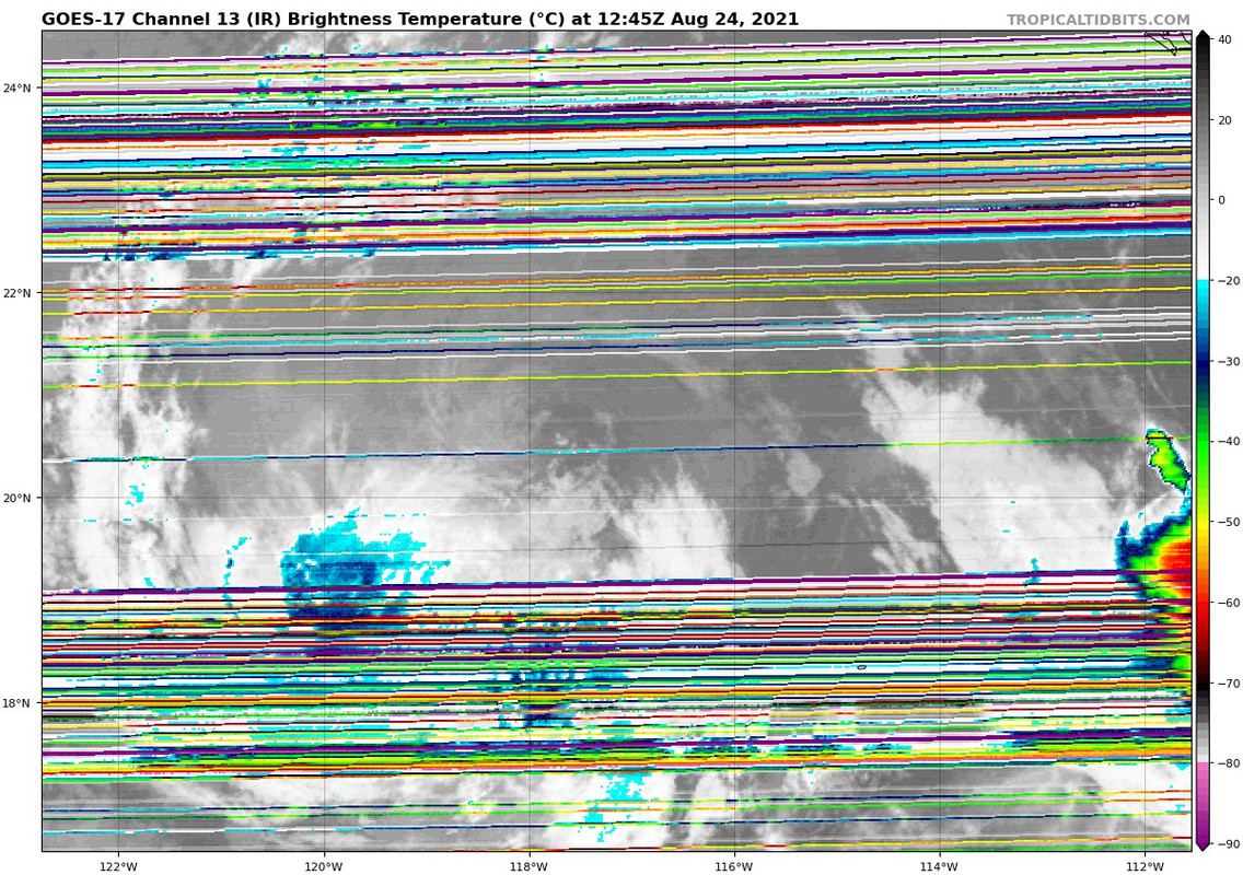
What's going on with the satellite out there?
0 likes
"But it never rained rain. It never snowed snow. And it never blew just wind. It rained things like soup and juice. It snowed mashed potatoes and green peas. And sometimes the wind blew in storms of hamburgers." -- Judi Barrett, Cloudy with a Chance of Meatballs
-
Yellow Evan
- Professional-Met
- Posts: 15951
- Age: 25
- Joined: Fri Jul 15, 2011 12:48 pm
- Location: Henderson, Nevada/Honolulu, HI
- Contact:
-
AlphaToOmega
- Category 5
- Posts: 1448
- Joined: Sat Jun 26, 2021 10:51 am
- Location: Somewhere in Massachusetts
Re: EPAC: MARTY - Tropical Depression
000
WTPZ43 KNHC 241433
TCDEP3
Tropical Depression Marty Discussion Number 6
NWS National Hurricane Center Miami FL EP132021
800 AM PDT Tue Aug 24 2021
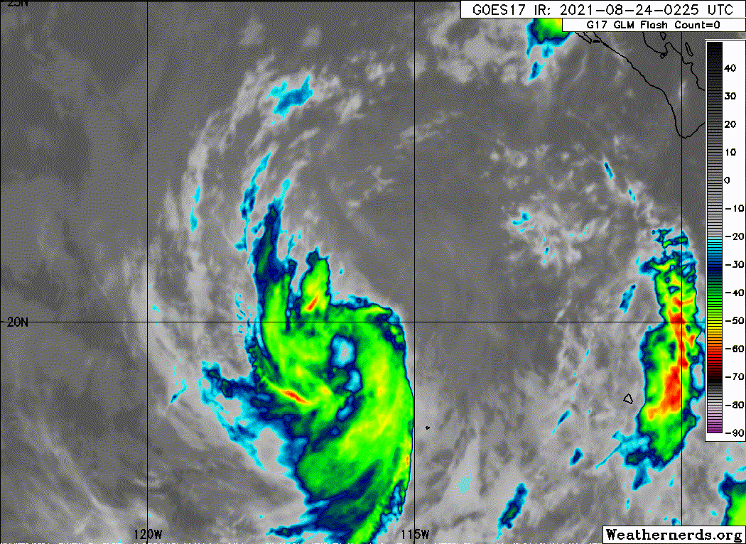
There has been no significant deep convection within 100 nmi of
Marty's center since about 0600 UTC. The cyclone's cloud pattern now
consists of some mid-level clouds and mostly low-level cold-air
stratocumulus clouds. The current intensity of 30 kt is based on a
unanimous Dvorak satellite classification of T1.5/2.5 (25 kt/35 kt)
from TAFB and SAB, which has resulted in Marty being downgraded to
a tropical depression. Due to the cyclone's future track remaining
over sub-26C sea-surface temperatures, coupled with additional
entrainment of stable low clouds, Marty is now forecast to
degenerate to a post-tropical remnant low later today. The new
NHC intensity forecast closely follows the trends of the intensity
consensus models IVCN and NOAA-HCCA.
The initial motion remains westward, or 270/10 kt. The strong
deep-layer ridge to the north of the weakening shallow cyclone is
expected to keep Marty on a generally westward track over the next
36 hours or so, followed by a west-southwestward motion thereafter
until the cyclone dissipates. The new official forecast track lies
near the extreme southern edge of the model guidance envelope, owing
to the models' slight poleward bias noted over the past 36 hours.
FORECAST POSITIONS AND MAX WINDS
INIT 24/1500Z 20.6N 118.1W 30 KT 35 MPH
12H 25/0000Z 20.6N 119.9W 25 KT 30 MPH...POST-TROP/REMNT LOW
24H 25/1200Z 20.6N 121.9W 25 KT 30 MPH...POST-TROP/REMNT LOW
36H 26/0000Z 20.6N 124.0W 20 KT 25 MPH...POST-TROP/REMNT LOW
48H 26/1200Z 20.5N 126.1W 20 KT 25 MPH...POST-TROP/REMNT LOW
60H 27/0000Z 20.2N 128.4W 20 KT 25 MPH...POST-TROP/REMNT LOW
72H 27/1200Z 19.6N 130.9W 20 KT 25 MPH...POST-TROP/REMNT LOW
96H 28/1200Z...POST-TROP/REMNT LOW
$$
Forecaster Stewart
WTPZ43 KNHC 241433
TCDEP3
Tropical Depression Marty Discussion Number 6
NWS National Hurricane Center Miami FL EP132021
800 AM PDT Tue Aug 24 2021
There has been no significant deep convection within 100 nmi of
Marty's center since about 0600 UTC. The cyclone's cloud pattern now
consists of some mid-level clouds and mostly low-level cold-air
stratocumulus clouds. The current intensity of 30 kt is based on a
unanimous Dvorak satellite classification of T1.5/2.5 (25 kt/35 kt)
from TAFB and SAB, which has resulted in Marty being downgraded to
a tropical depression. Due to the cyclone's future track remaining
over sub-26C sea-surface temperatures, coupled with additional
entrainment of stable low clouds, Marty is now forecast to
degenerate to a post-tropical remnant low later today. The new
NHC intensity forecast closely follows the trends of the intensity
consensus models IVCN and NOAA-HCCA.
The initial motion remains westward, or 270/10 kt. The strong
deep-layer ridge to the north of the weakening shallow cyclone is
expected to keep Marty on a generally westward track over the next
36 hours or so, followed by a west-southwestward motion thereafter
until the cyclone dissipates. The new official forecast track lies
near the extreme southern edge of the model guidance envelope, owing
to the models' slight poleward bias noted over the past 36 hours.
FORECAST POSITIONS AND MAX WINDS
INIT 24/1500Z 20.6N 118.1W 30 KT 35 MPH
12H 25/0000Z 20.6N 119.9W 25 KT 30 MPH...POST-TROP/REMNT LOW
24H 25/1200Z 20.6N 121.9W 25 KT 30 MPH...POST-TROP/REMNT LOW
36H 26/0000Z 20.6N 124.0W 20 KT 25 MPH...POST-TROP/REMNT LOW
48H 26/1200Z 20.5N 126.1W 20 KT 25 MPH...POST-TROP/REMNT LOW
60H 27/0000Z 20.2N 128.4W 20 KT 25 MPH...POST-TROP/REMNT LOW
72H 27/1200Z 19.6N 130.9W 20 KT 25 MPH...POST-TROP/REMNT LOW
96H 28/1200Z...POST-TROP/REMNT LOW
$$
Forecaster Stewart
0 likes
-
cycloneye
- Admin
- Posts: 139046
- Age: 67
- Joined: Thu Oct 10, 2002 10:54 am
- Location: San Juan, Puerto Rico
Re: EPAC: MARTY - Tropical Depression
Tropical Depression Marty Discussion Number 6
NWS National Hurricane Center Miami FL EP132021
800 AM PDT Tue Aug 24 2021
There has been no significant deep convection within 100 nmi of
Marty's center since about 0600 UTC. The cyclone's cloud pattern now
consists of some mid-level clouds and mostly low-level cold-air
stratocumulus clouds. The current intensity of 30 kt is based on a
unanimous Dvorak satellite classification of T1.5/2.5 (25 kt/35 kt)
from TAFB and SAB, which has resulted in Marty being downgraded to
a tropical depression. Due to the cyclone's future track remaining
over sub-26C sea-surface temperatures, coupled with additional
entrainment of stable low clouds, Marty is now forecast to
degenerate to a post-tropical remnant low later today. The new
NHC intensity forecast closely follows the trends of the intensity
consensus models IVCN and NOAA-HCCA.
The initial motion remains westward, or 270/10 kt. The strong
deep-layer ridge to the north of the weakening shallow cyclone is
expected to keep Marty on a generally westward track over the next
36 hours or so, followed by a west-southwestward motion thereafter
until the cyclone dissipates. The new official forecast track lies
near the extreme southern edge of the model guidance envelope, owing
to the models' slight poleward bias noted over the past 36 hours.
FORECAST POSITIONS AND MAX WINDS
INIT 24/1500Z 20.6N 118.1W 30 KT 35 MPH
12H 25/0000Z 20.6N 119.9W 25 KT 30 MPH...POST-TROP/REMNT LOW
24H 25/1200Z 20.6N 121.9W 25 KT 30 MPH...POST-TROP/REMNT LOW
36H 26/0000Z 20.6N 124.0W 20 KT 25 MPH...POST-TROP/REMNT LOW
48H 26/1200Z 20.5N 126.1W 20 KT 25 MPH...POST-TROP/REMNT LOW
60H 27/0000Z 20.2N 128.4W 20 KT 25 MPH...POST-TROP/REMNT LOW
72H 27/1200Z 19.6N 130.9W 20 KT 25 MPH...POST-TROP/REMNT LOW
96H 28/1200Z...POST-TROP/REMNT LOW
$$
Forecaster Stewart
0 likes
Visit the Caribbean-Central America Weather Thread where you can find at first post web cams,radars
and observations from Caribbean basin members Click Here
and observations from Caribbean basin members Click Here
-
Sciencerocks
- Category 5
- Posts: 7282
- Age: 38
- Joined: Thu Jul 06, 2017 1:51 am

-
Yellow Evan
- Professional-Met
- Posts: 15951
- Age: 25
- Joined: Fri Jul 15, 2011 12:48 pm
- Location: Henderson, Nevada/Honolulu, HI
- Contact:
Re: EPAC: MARTY - Tropical Depression
TXPZ24 KNES 241800
TCSENP
A. 13E (MARTY)
B. 24/1730Z
C. 20.4N
D. 118.4W
E. THREE/GOES-W
F. TOO WEAK
G. IR/EIR/VIS
H. REMARKS...THIS SYSTEM IS TOO WEAK TO CLASSIFY DUE TO A LACK OF
DEEP CONVECTION NEAR THE LLCC. THIS WILL BE THE FINAL BULLETIN UNLESS
REGENERATION OCCURS.
I. ADDL POSITIONS
NIL
...MLEVINE
TCSENP
A. 13E (MARTY)
B. 24/1730Z
C. 20.4N
D. 118.4W
E. THREE/GOES-W
F. TOO WEAK
G. IR/EIR/VIS
H. REMARKS...THIS SYSTEM IS TOO WEAK TO CLASSIFY DUE TO A LACK OF
DEEP CONVECTION NEAR THE LLCC. THIS WILL BE THE FINAL BULLETIN UNLESS
REGENERATION OCCURS.
I. ADDL POSITIONS
NIL
...MLEVINE
0 likes
-
Yellow Evan
- Professional-Met
- Posts: 15951
- Age: 25
- Joined: Fri Jul 15, 2011 12:48 pm
- Location: Henderson, Nevada/Honolulu, HI
- Contact:
Re: EPAC: MARTY - Tropical Depression
Has been devoid of deep convection for 12 hours. Plug can be pulled here.
0 likes
Who is online
Users browsing this forum: No registered users and 24 guests