ATL: KATE - Remnants - Discussion

Moderator: S2k Moderators

Message
Author
User avatar
cycloneye
Admin
Admin
Posts: 139008
Age: 67
Joined: Thu Oct 10, 2002 10:54 am
Location: San Juan, Puerto Rico

Re: ATL: TEN - Tropical Depression - Discussion

#101 Postby cycloneye » Sat Aug 28, 2021 9:38 am

Tropical Depression Ten Discussion Number 2
NWS National Hurricane Center Miami FL AL102021
1100 AM AST Sat Aug 28 2021

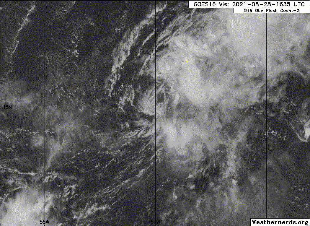
First light visible imagery shows that the rather disorganized
surface center is exposed near the western edge of the cloud mass.
The associated deep convection has been diminishing during the past
6 hours due to the stiff west-northwesterly shear and a rather
parched surrounding thermodynamic environment. The initial
intensity is held at 30 kt, consistent with the Dvorak satellite
intensity estimates from TAFB and SAB and the 1156 UTC METOP-A
scatterometer pass.

The statistical SHIPS intensity guidance shows that the shear should
decrease somewhat tonight and into Sunday, which should allow for
some strengthening. By Monday, the aforementioned model, along
with the deterministic guidance, indicates an increase in the shear
magnitude and even lower mid- tropospheric relative humidity
values, which should cap further strengthening and weaken the
cyclone back to a depression through the remainder of the forecast
period. There's more agreement in the large-scale models this
morning indicating that the depression will degenerate into a
remnant low toward the end of the week, and the NHC forecast
follows suit. This is the only change from the previous advisory,
and the NHC intensity forecast closely resembles the skilled IVCN
and HCCA intensity consensus aids.

The initial motion is estimated to be northward, or 350/7 kt. The
depression is embedded in low- to mid-level southerly flow produced
by a mid-Atlantic trough stretching from the northeast Atlantic to
the central tropical Atlantic. This feature, along with a
subtropical ridge situated over the east Atlantic and western
Africa, should steer the depression generally toward the north
through the 5-day period. The official track forecast has been
nudged to the right of the previous advisory beyond day 3, and is
close to the TVCN and NOAA HCCA multimodel guidance.

FORECAST POSITIONS AND MAX WINDS

INIT 28/1500Z 14.8N 50.0W 30 KT 35 MPH
12H 29/0000Z 15.7N 50.2W 30 KT 35 MPH
24H 29/1200Z 17.1N 50.1W 35 KT 40 MPH
36H 30/0000Z 18.6N 50.0W 35 KT 40 MPH
48H 30/1200Z 20.1N 49.7W 30 KT 35 MPH
60H 31/0000Z 21.4N 49.4W 30 KT 35 MPH
72H 31/1200Z 22.7N 49.4W 30 KT 35 MPH
96H 01/1200Z 25.4N 50.6W 30 KT 35 MPH
120H 02/1200Z 28.6N 51.6W 25 KT 30 MPH...POST-TROP/REMNT LOW

$$
Forecaster Roberts
0 likes   
Visit the Caribbean-Central America Weather Thread where you can find at first post web cams,radars
and observations from Caribbean basin members Click Here

User avatar
aspen
Category 5
Category 5
Posts: 8054
Joined: Sat Oct 12, 2019 7:10 pm
Location: Connecticut, USA

Re: ATL: TEN - Tropical Depression - Discussion

#102 Postby aspen » Sat Aug 28, 2021 10:28 am

I guess future 90L will be getting the name Julian…poor TD10 looks awful.
0 likes   
Irene '11 Sandy '12 Hermine '16 5/15/2018 Derecho Fay '20 Isaias '20 Elsa '21 Henri '21 Ida '21

I am only a meteorology enthusiast who knows a decent amount about tropical cyclones. Look to the professional mets, the NHC, or your local weather office for the best information.

AlphaToOmega
Category 5
Category 5
Posts: 1448
Joined: Sat Jun 26, 2021 10:51 am
Location: Somewhere in Massachusetts

Re: ATL: TEN - Tropical Depression - Discussion

#103 Postby AlphaToOmega » Sat Aug 28, 2021 10:43 am

aspen wrote:I guess future 90L will be getting the name Julian…poor TD10 looks awful.

The HWRF shows a tropical storm.
0 likes   

User avatar
wxman57
Moderator-Pro Met
Moderator-Pro Met
Posts: 22480
Age: 66
Joined: Sat Jun 21, 2003 8:06 pm
Location: Houston, TX (southwest)

Re: ATL: TEN - Tropical Depression - Discussion

#104 Postby wxman57 » Sat Aug 28, 2021 12:08 pm

Bones is having a hard look at this so-called depression... The non-depression to its north looks much more impressive (97L)
1 likes   

User avatar
EquusStorm
Category 5
Category 5
Posts: 1649
Age: 33
Joined: Thu Nov 07, 2013 1:04 pm
Location: Jasper, AL
Contact:

Re: ATL: TEN - Tropical Depression - Discussion

#105 Postby EquusStorm » Sat Aug 28, 2021 1:58 pm

This looked great yesterday evening then again when it was designated but honestly it's making TD11 2018 look good in comparison right now. Very fragile looking LLC; seems to me like a toss-up whether it makes it to better conditions. Interested to see what it does in the overnight convective maximum.
0 likes   
Colors of lost purpose on the canvas of irrelevance

Not a meteorologist, in fact more of an idiot than anything. You should probably check with the NHC or a local NWS office for official information.

Sciencerocks
Category 5
Category 5
Posts: 7282
Age: 38
Joined: Thu Jul 06, 2017 1:51 am

Re: ATL: TEN - Tropical Depression - Discussion

#106 Postby Sciencerocks » Sat Aug 28, 2021 3:06 pm

Image
0 likes   

User avatar
cycloneye
Admin
Admin
Posts: 139008
Age: 67
Joined: Thu Oct 10, 2002 10:54 am
Location: San Juan, Puerto Rico

Re: ATL: TEN - Tropical Depression - Discussion

#107 Postby cycloneye » Sat Aug 28, 2021 3:34 pm

BULLETIN
Tropical Depression Ten Advisory Number 3
NWS National Hurricane Center Miami FL AL102021
500 PM AST Sat Aug 28 2021

...DEPRESSION STILL STRUGGLING WHILE MOVING NORTHWARD...


SUMMARY OF 500 PM AST...2100 UTC...INFORMATION
----------------------------------------------
LOCATION...15.6N 50.0W
ABOUT 790 MI...1270 KM E OF THE LEEWARD ISLANDS
MAXIMUM SUSTAINED WINDS...35 MPH...55 KM/H
PRESENT MOVEMENT...N OR 360 DEGREES AT 8 MPH...13 KM/H
MINIMUM CENTRAL PRESSURE...1007 MB...29.74 INCHES


WATCHES AND WARNINGS
--------------------
There are no coastal watches or warnings in effect.


DISCUSSION AND OUTLOOK
----------------------
At 500 PM AST (2100 UTC), the center of Tropical Depression Ten was
located near latitude 15.6 North, longitude 50.0 West. The
depression is moving toward the north near 8 mph (13 km/h) and this
general motion is forecast to continue during the next several days.

Maximum sustained winds are near 35 mph (55 km/h) with higher gusts.
Some slight strengthening is forecast, and the depression is
expected to become a tropical storm by Sunday.

The estimated minimum central pressure is 1007 mb (29.74 inches).


HAZARDS AFFECTING LAND
----------------------
None.


NEXT ADVISORY
-------------
Next complete advisory at 1100 PM AST.

$$
Forecaster Roberts

Tropical Depression Ten Discussion Number 3
NWS National Hurricane Center Miami FL AL102021
500 PM AST Sat Aug 28 2021

This afternoon's satellite presentation consists of an exposed
surface circulation with a rather shapeless convective mass
displaced to the east and north of the center. Without question,
the 15 to 20 kt of west-northwesterly shear is doing a number on
the cloud pattern. Also evident, are a number of arc clouds
propagating away from the system's deep convection, certainly
indicative of dry air intrusion. Consequently, the initial
intensity is once again held at 30 kt for this advisory.

The global models as well as the Decay SHIPS (ECMWF/GFS) intensity
guidance still show the shear relaxing a bit tonight and into
Sunday, which should allow the depression to briefly become a
tropical storm. By Monday, however, the shear is forecast to
increase while the cyclone moves into an even more dry and stable
air mass. These inhibiting contributions should stifle further
strengthening and weaken the cyclone back to a depression through
the remainder of the forecast period. It's worth mentioning that
the GFS indicates that the depression will become a remnant low in
72 hours while turning northwestward to west-northwestward within
the tradewind flow and dissipate by the end of the week. For now,
the NHC forecast will stick with the consensus intensity models and
the SHIPS guidance which agree on maintaining a depression through
day 5.

The initial motion is estimated to be northward, or 360/7 kt. The
depression remains embedded in low- to mid-level southerly flow
produced by a mid-Atlantic trough dominating the central Atlantic.
This synoptic feature, along with a subtropical high pressure
located over the east Atlantic and western Africa, should influence
a generally northward motion through the 5-day period. The
official track forecast again is adjusted a little to the right of
the previous advisory beyond day 3, and lies between the TVCN and
HCCA multimodel solutions.


FORECAST POSITIONS AND MAX WINDS

INIT 28/2100Z 15.6N 50.0W 30 KT 35 MPH
12H 29/0600Z 16.6N 50.0W 35 KT 40 MPH
24H 29/1800Z 18.2N 49.9W 35 KT 40 MPH
36H 30/0600Z 19.8N 49.7W 30 KT 35 MPH
48H 30/1800Z 21.3N 49.3W 30 KT 35 MPH
60H 31/0600Z 22.5N 48.8W 30 KT 35 MPH
72H 31/1800Z 23.8N 49.0W 30 KT 35 MPH
96H 01/1800Z 27.2N 50.5W 30 KT 35 MPH
120H 02/1800Z 30.5N 51.5W 30 KT 35 MPH

$$
Forecaster Roberts
0 likes   
Visit the Caribbean-Central America Weather Thread where you can find at first post web cams,radars
and observations from Caribbean basin members Click Here

Sciencerocks
Category 5
Category 5
Posts: 7282
Age: 38
Joined: Thu Jul 06, 2017 1:51 am

Re: ATL: TEN - Tropical Depression - Discussion

#108 Postby Sciencerocks » Sat Aug 28, 2021 9:17 pm

Image
0 likes   

User avatar
Teban54
Category 5
Category 5
Posts: 1946
Joined: Sat May 19, 2018 1:19 pm

Re: ATL: TEN - Tropical Depression - Discussion

#109 Postby Teban54 » Sat Aug 28, 2021 9:18 pm


Back to life again for the time being... Still won't last long, but don't forget most models didn't even have this developing.
0 likes   

User avatar
weeniepatrol
Category 3
Category 3
Posts: 854
Joined: Sat Aug 22, 2020 5:30 pm
Location: WA State

Re: ATL: TEN - Tropical Depression - Discussion

#110 Postby weeniepatrol » Sat Aug 28, 2021 9:41 pm

Forecast to be strengthening at the end of the forecast period now.

Tropical Depression Ten Discussion Number 4
NWS National Hurricane Center Miami FL AL102021
1100 PM AST Sat Aug 28 2021

The center of the tropical depression remained exposed for much of
the evening, though in the past hour or so the center has become
located closer to a small, ragged area of convection. A more
pronounced curved band can also be seen east of the depression
though this feature is located over 120 n mi away. This structure is
due to ongoing west-southwesterly shear and the presence of some dry
air that continues to plague the cyclone. The latest Dvorak
intensity estimate from TAFB and wind data from a recent ASCAT-B
overpass indicate the initial intensity remains 30 kt.

Some slight strengthening is possible later tonight through Sunday
morning as a slight decrease in shear combined with the diurnal
convective maximum may allow the depression to become a tropical
storm. Thereafter through 60 h, the shear is forecast to increase,
while the system moves into an drier environment. Thus, no further
strengthening is forecast during this period, and the cyclone could
weaken back into a tropical depression. By around 72 h, global
models are suggesting that the shear will decrease again. So, some
gradual strengthening is forecast after that time. It should also be
noted that the GFS, which earlier forecast the system to degenerate
into a remnant low in a few days, now keeps the cyclone in tact and
deepens it when the shear lessens toward the end of the 5-day
forecast period. The latest NHC intensity forecast is close to the
previous one through 24 h, but is higher beyond 24 h. This forecast
is a blend of the SHIPS and IVCN guidance through 72 h, but is lower
than those solutions after that time.

The depression is moving toward the north at 9 kt toward a weakness
in the subtropical ridge, carved out by a mid- to upper-level trough
over the north-central Atlantic. This trough and associated ridge
weakness is forecast to remain in place for the next few days,
resulting in the cyclone continuing a general northward motion. By
late in the forecast period, the trough is expected to lift out
of the region and be replaced by a ridge, which would result in the
system turning northwestward. The latest NHC track forecast is
little changed from the previous one and lies near the various
multi-model consensus tracks.


FORECAST POSITIONS AND MAX WINDS

INIT 29/0300Z 16.6N 49.9W 30 KT 35 MPH
12H 29/1200Z 17.7N 49.9W 35 KT 40 MPH
24H 30/0000Z 19.4N 49.9W 35 KT 40 MPH
36H 30/1200Z 20.8N 49.7W 35 KT 40 MPH
48H 31/0000Z 22.3N 49.2W 35 KT 40 MPH
60H 31/1200Z 23.5N 49.0W 35 KT 40 MPH
72H 01/0000Z 25.0N 49.2W 40 KT 45 MPH
96H 02/0000Z 28.2N 50.6W 40 KT 45 MPH
120H 03/0000Z 31.5N 51.7W 45 KT 50 MPH

$$
Forecaster Latto
1 likes   

User avatar
galaxy401
Category 5
Category 5
Posts: 2298
Age: 28
Joined: Sat Aug 25, 2012 9:04 pm
Location: Casa Grande, Arizona

Re: ATL: TEN - Tropical Depression - Discussion

#111 Postby galaxy401 » Sat Aug 28, 2021 9:57 pm

Future Julian or Kate going to be around for awhile. Just going to slowly churn north. With that uncertainty, this storm could go either way intensity wise.
0 likes   
Got my eyes on moving right into Hurricane Alley: Florida.

User avatar
ElectricStorm
Category 5
Category 5
Posts: 4521
Age: 23
Joined: Tue Aug 13, 2019 11:23 pm
Location: Skiatook, OK / Norman, OK

Re: ATL: TEN - Tropical Depression - Discussion

#112 Postby ElectricStorm » Sat Aug 28, 2021 10:45 pm

Hmm maybe this little guy has a chance after all. Quite the reversal on the intensity forecast this advisory
1 likes   
I am in no way a professional. Take what I say with a grain of salt as I could be totally wrong. Please refer to the NHC, NWS, or SPC for official information.

Boomer Sooner!

User avatar
cycloneye
Admin
Admin
Posts: 139008
Age: 67
Joined: Thu Oct 10, 2002 10:54 am
Location: San Juan, Puerto Rico

Re: ATL: TEN - Tropical Depression - Discussion

#113 Postby cycloneye » Sat Aug 28, 2021 11:09 pm

It was going to dissipate but aparently is going to get pockets of less ahear to allow it to be a storm for a few days.
0 likes   
Visit the Caribbean-Central America Weather Thread where you can find at first post web cams,radars
and observations from Caribbean basin members Click Here

User avatar
aspen
Category 5
Category 5
Posts: 8054
Joined: Sat Oct 12, 2019 7:10 pm
Location: Connecticut, USA

Re: ATL: TEN - Tropical Depression - Discussion

#114 Postby aspen » Sun Aug 29, 2021 5:17 am

I was gonna write this guy off, but looks like it has a chance to contribute to the season’s ACE and not be a weak 12-24hr TS. Since it’ll be going due north instead of recurving, this’ll put it within a nice warm spot in the subtropics, which could allow it to become a high-latitude hurricane by midweek. The HWRF makes this a Cat 3 — typical HWRF, but the potential for a hurricane is there.
1 likes   
Irene '11 Sandy '12 Hermine '16 5/15/2018 Derecho Fay '20 Isaias '20 Elsa '21 Henri '21 Ida '21

I am only a meteorology enthusiast who knows a decent amount about tropical cyclones. Look to the professional mets, the NHC, or your local weather office for the best information.

Sciencerocks
Category 5
Category 5
Posts: 7282
Age: 38
Joined: Thu Jul 06, 2017 1:51 am

Re: ATL: TEN - Tropical Depression - Discussion

#115 Postby Sciencerocks » Sun Aug 29, 2021 5:24 am

Image
0 likes   

User avatar
cycloneye
Admin
Admin
Posts: 139008
Age: 67
Joined: Thu Oct 10, 2002 10:54 am
Location: San Juan, Puerto Rico

Re: ATL: TEN - Tropical Depression - Discussion

#116 Postby cycloneye » Sun Aug 29, 2021 6:26 am

Tropical Depression Ten Discussion Number 5
NWS National Hurricane Center Miami FL AL102021
500 AM AST Sun Aug 29 2021

Tropical Depression Ten continues to struggle against 25-30 kt of
northwesterly vertical wind shear, as diagnosed by the latest SHIPS
guidance. Convection has thus remained displaced primarily to the
southeast, though with some recent cells trying to develop closer to
the center. The most recent TAFB and SAB Dvorak estimates were
T2.5/35 kt and T2.0/30 kt with the objective ADT estimate at T2.3/33
kt. Given the disorganized nature of the current structure on IR
satellite, I have elected to stay on the conservative side of these
estimates and hold the intensity at 30 kt for this advisory.

The depression continues to move toward the north at 360/9 kt. A
large weakness in the mid-level ridging, due to a strong
upper-tropospheric trough, will allow the depression to continue
moving northward in the short-term, though there may be some
occasional eastward bends as downshear convection tugs at the
low-level vortex of the system. However by 72 h, some mid-level
ridging is expected to build back in, allowing the track to shift a
bit more leftward to the north-northwest after this point. The track
guidance has not shifted much over the forecast period, and the
latest NHC track forecast is nearly on top of the previous one,
continuing to favor a blend of the the consensus aids (HCCA, TVCN).

The poor current structure of the depression, under high shear
importing dry air, argues against much short term intensification.
However, the ECMWF-SHIPS guidance still suggests a brief respite in
the shear between 12-24 hours. For this reason, the NHC intensity
forecast still shows some slight strengthening to a tropical storm
in 24 hours. Another round of 25-30 kt of vertical wind shear
between 24-48 hours is then expected to keep the system in check,
and it remains possible that the cyclone could degenerate to a
remnant low over this time period. However, by 72 hours, the
upper-level trough shearing the system is forecast to cut-off to the
southwest, and this will shift the upper-level flow from
northwesterly to southeasterly, which should provide a more
favorable environment for strengthening. Thus, gradual
strengthening is shown beginning in 72 hours extending through the
end of the forecast. The latest NHC intensity forecast is quite
similar to the previous forecast, favoring the more pessimistic
ECMWF guidance versus the more aggressive GFS and regional hurricane
models. There is quite a bit of uncertainty in the latter portion of
this forecast since it is unclear how much of the cyclone will
survive the current unfavorable environment during the next 2-3
days.


FORECAST POSITIONS AND MAX WINDS

INIT 29/0900Z 17.3N 49.8W 30 KT 35 MPH
12H 29/1800Z 18.4N 49.8W 30 KT 35 MPH
24H 30/0600Z 19.9N 49.8W 35 KT 40 MPH
36H 30/1800Z 21.4N 49.4W 35 KT 40 MPH
48H 31/0600Z 22.7N 48.9W 35 KT 40 MPH
60H 31/1800Z 24.0N 48.9W 35 KT 40 MPH
72H 01/0600Z 25.6N 49.3W 40 KT 45 MPH
96H 02/0600Z 29.0N 50.5W 45 KT 50 MPH
120H 03/0600Z 32.0N 51.0W 50 KT 60 MPH

$$
Forecaster Papin
0 likes   
Visit the Caribbean-Central America Weather Thread where you can find at first post web cams,radars
and observations from Caribbean basin members Click Here

User avatar
aspen
Category 5
Category 5
Posts: 8054
Joined: Sat Oct 12, 2019 7:10 pm
Location: Connecticut, USA

Re: ATL: TEN - Tropical Depression - Discussion

#117 Postby aspen » Sun Aug 29, 2021 9:43 am

New forecast peak is up to 55kt. The NHC says this can become a TS anytime within the next 48 hours if some more convection stays over the LLC. Afterwards, shear will lessen while Kate is over 27-28C SSTs. I think it has a decent shot to become a hurricane.
1 likes   
Irene '11 Sandy '12 Hermine '16 5/15/2018 Derecho Fay '20 Isaias '20 Elsa '21 Henri '21 Ida '21

I am only a meteorology enthusiast who knows a decent amount about tropical cyclones. Look to the professional mets, the NHC, or your local weather office for the best information.

Sciencerocks
Category 5
Category 5
Posts: 7282
Age: 38
Joined: Thu Jul 06, 2017 1:51 am

Re: ATL: TEN - Tropical Depression - Discussion

#118 Postby Sciencerocks » Sun Aug 29, 2021 12:56 pm

Image
1 likes   

User avatar
ElectricStorm
Category 5
Category 5
Posts: 4521
Age: 23
Joined: Tue Aug 13, 2019 11:23 pm
Location: Skiatook, OK / Norman, OK

Re: ATL: TEN - Tropical Depression - Discussion

#119 Postby ElectricStorm » Sun Aug 29, 2021 1:39 pm

Weather Dude wrote:Almost a swirl alert. I don't really see this one getting very strong at all, maybe a weak TS, similar to the NHC forecast.

#badS2Ktakes :lol:
Yeah this one looks to have some potential after all. As long as Bermuda doesn't come into play I'll be rooting for it
1 likes   
I am in no way a professional. Take what I say with a grain of salt as I could be totally wrong. Please refer to the NHC, NWS, or SPC for official information.

Boomer Sooner!

Sciencerocks
Category 5
Category 5
Posts: 7282
Age: 38
Joined: Thu Jul 06, 2017 1:51 am

Re: ATL: TEN - Tropical Depression - Discussion

#120 Postby Sciencerocks » Sun Aug 29, 2021 2:59 pm

Image
1 likes   


Return to “2021”

Who is online

Users browsing this forum: No registered users and 10 guests