Tropical Storm Nora Discussion Number 10
NWS National Hurricane Center Miami FL EP142021
1000 PM CDT Fri Aug 27 2021
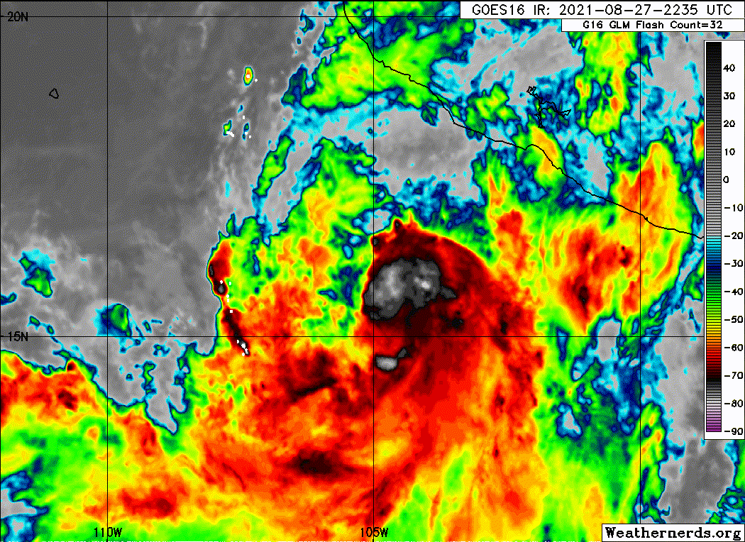
Nora's cloud pattern has not become much better organized since
earlier today. The central convection has diminished, but this is
likely a diurnal fluctuation. Upper-level outflow appears to be
fairly well-defined, with convective banding features most
prominent over the southern portion of the circulation. Dvorak
intensity estimates from both TAFB and SAB remain at 55 kt, so the
advisory intensity will be held at that value for now.
The storm has been moving a little to the east of the previous
track over the past few hours, but the longer-term motion estimate
is still northwestward, or 325/9 kt. Nora should move on a
northwestward or north-northwestward heading for the next 2-3 days
on the southwestern side of a mid-tropospheric anticyclone. Late
in the forecast period, the cyclone is forecast to turn northward
as the ridge to its north weakens. The official forecast track has
been nudged just a bit to the east of the previous one during the
next 72 hours or so, but not as far east as the latest dynamical
model consensus, TVCE.
Nora is expected to be in a moist, low-shear environment for the
next few days, so the atmospheric conditions should favor
intensification into a hurricane. Nonetheless, the majority of the
intensity guidance does not show much strengthening beyond 24 hours,
probably due to land interaction. The official intensity forecast
shows gradual strengthening for the next couple of days or so, and
is similar to the previous one. This is close to the LGEM guidance
based on the ECMWF global model fields. It should be noted that
there is significant uncertainty in the future strength of Nora
because of the possible influence of land.
Key Messages:
1. Nora is forecast to strengthen to a hurricane on Saturday while
passing nearby the coasts of the Mexican states of Jalisco and
Nayarit, and hurricane watches and tropical storm warnings are
in effect for portions of that coastline. Interests in these areas
should closely monitor the progress of Nora and subsequent updates
to the forecast.
2.Heavy rain associated with Nora is expected across coastal
sections of the Mexican states of Guerrero, Michoacan, Colima, and
Jalisco, as well as Baja California Sur. Life-threatening flash
flooding and mudslides are expected.
3. Nora is forecast to move over the Gulf of California as a
hurricane early next week, bringing a risk of wind and rain impacts
to portions of the Mexican states of Baja California Sur, Sinaloa,
and Sonora. Given the above-average uncertainty in the forecast,
it is still too soon to determine the magnitude and location of
these potential impacts.
FORECAST POSITIONS AND MAX WINDS
INIT 28/0300Z 16.3N 105.1W 55 KT 65 MPH
12H 28/1200Z 17.6N 105.6W 60 KT 70 MPH
24H 29/0000Z 19.6N 106.2W 65 KT 75 MPH
36H 29/1200Z 21.6N 107.0W 70 KT 80 MPH
48H 30/0000Z 22.7N 107.9W 75 KT 85 MPH
60H 30/1200Z 23.6N 108.6W 80 KT 90 MPH
72H 31/0000Z 24.5N 109.3W 80 KT 90 MPH
96H 01/0000Z 26.5N 111.0W 70 KT 80 MPH
120H 02/0000Z 29.5N 111.5W 45 KT 50 MPH...INLAND
$$
Forecaster Pasch