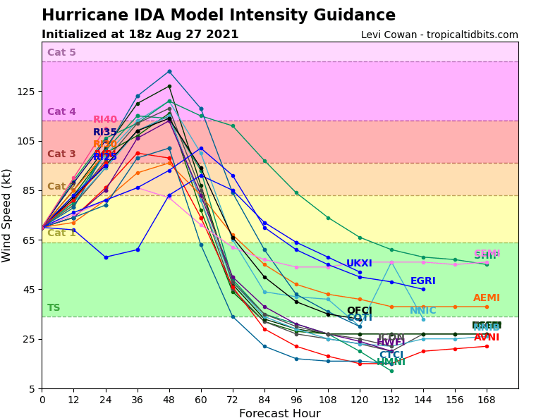
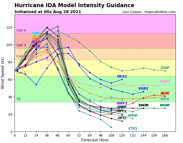
ATL: IDA - Models

Moderator: S2k Moderators

Message
Author
tolakram
Admin
Admin
Posts: 19165
Age: 60
Joined: Sun Aug 27, 2006 8:23 pm
Location: Florence, KY (name is Mark)

Re: ATL: IDA - Models

#981 Postby tolakram » Fri Aug 27, 2021 8:48 pm

LARanger wrote:
tolakram wrote:?? Spreading out?


See the "Global + Hurricane Models" Tidbits graphic now versus the last . . . the last one had a tighter group. Similarly, the model intensity guidance graphic no longer shows some straining toward 5, but instead clustering closer to the 3/4 border again.


Some of the models included in that graph are pure crap, and while interesting to look at are otherwise meaningless. Grouped or not grouped will be a little random.
4 likes   
M a r k
- - - - -
Join us in chat: Storm2K Chatroom Invite. Android and IOS apps also available.

The posts in this forum are NOT official forecasts and should not be used as such. Posts are NOT endorsed by any professional institution or STORM2K.org. For official information and forecasts, please refer to NHC and NWS products.

User avatar
Category5Kaiju
Category 5
Category 5
Posts: 3352
Age: 22
Joined: Thu Dec 24, 2020 12:45 pm
Location: Seattle

Re: ATL: IDA - Models

#982 Postby Category5Kaiju » Fri Aug 27, 2021 9:44 pm

chaser1 wrote:
TallahasseeMan wrote:Peak strength shown on HWRF over the last 4 runs.

0z 950mb
6z 940mb
12z 938mb
18z 933mb


A very scary trend indeed


Wouldn't be shocked to see a 920s mbar landfall on the next model run
0 likes   
Unless explicitly stated, all information covered in my posts is based on my opinions and observations. Please refer to a professional meteorologist or an accredited weather research agency otherwise, especially if serious decisions must be made in the event of a potentially life-threatening tropical storm or hurricane.

User avatar
PTPatrick
Category 5
Category 5
Posts: 1827
Joined: Sat Jun 12, 2004 8:38 am

Re: ATL: IDA - Models

#983 Postby PTPatrick » Fri Aug 27, 2021 9:45 pm

https://twitter.com/burgwx/status/1431442107135315971


Tomer Burg
@burgwx
The 18z run of the EPS + GEFS ensembles shows a concerning trend worth monitoring in future runs.

Ida's short-term track over the Gulf of Mexico has a more northerly component than the last run, shifting the ensemble distribution in landfall location east, closer to New Orleans.
0 likes   

shah83
Category 1
Category 1
Posts: 269
Joined: Sun Jul 31, 2016 4:55 pm

Re: ATL: IDA - Models

#984 Postby shah83 » Fri Aug 27, 2021 10:08 pm

00z icon getting pretty east shifty

edit to say that it's also showing a larger system, maybe a more important shift.
0 likes   

IcyTundra
Category 3
Category 3
Posts: 885
Joined: Mon Jun 07, 2021 9:32 pm
Location: Dickinson, Texas

Re: ATL: IDA - Models

#985 Postby IcyTundra » Fri Aug 27, 2021 10:15 pm

00Z ICON landfall over Port Fourchon.
0 likes   

BobHarlem
Category 5
Category 5
Posts: 1665
Joined: Thu Oct 20, 2005 6:11 pm

Re: ATL: IDA - Models

#986 Postby BobHarlem » Fri Aug 27, 2021 10:33 pm

Restating the above two posts, but 0z ICON shifts right quite a bit to Port Fourchon/Grand Isle. Only slightly stronger than the 18z run, though.
Image
0 likes   

User avatar
ElectricStorm
Category 5
Category 5
Posts: 4525
Age: 23
Joined: Tue Aug 13, 2019 11:23 pm
Location: Skiatook, OK / Norman, OK

Re: ATL: IDA - Models

#987 Postby ElectricStorm » Fri Aug 27, 2021 10:44 pm

0z GFS has it remaining around the current pressure for another 6 hours or so before taking off.
0 likes   
I am in no way a professional. Take what I say with a grain of salt as I could be totally wrong. Please refer to the NHC, NWS, or SPC for official information.

Boomer Sooner!

User avatar
PTPatrick
Category 5
Category 5
Posts: 1827
Joined: Sat Jun 12, 2004 8:38 am

Re: ATL: IDA - Models

#988 Postby PTPatrick » Fri Aug 27, 2021 10:51 pm

Weather Dude wrote:0z GFS has it remaining around the current pressure for another 6 hours or so before taking off.

And few mb stronger at 36 hrs but otherwise very little change from 18z so far
0 likes   

User avatar
ElectricStorm
Category 5
Category 5
Posts: 4525
Age: 23
Joined: Tue Aug 13, 2019 11:23 pm
Location: Skiatook, OK / Norman, OK

Re: ATL: IDA - Models

#989 Postby ElectricStorm » Fri Aug 27, 2021 10:54 pm

IMO the GFS is underdoing the intensity. Considering the current state of Ida and the conditions ahead of it, I just don't see how this will only get to 954mb. And that's pretty concerning as 954 is nothing to sneeze at.
2 likes   
I am in no way a professional. Take what I say with a grain of salt as I could be totally wrong. Please refer to the NHC, NWS, or SPC for official information.

Boomer Sooner!

PavelGaborik
Tropical Depression
Tropical Depression
Posts: 81
Joined: Thu Oct 06, 2016 11:13 pm

Re: ATL: IDA - Models

#990 Postby PavelGaborik » Fri Aug 27, 2021 10:55 pm

GFS actually looks slightly left.
0 likes   

shah83
Category 1
Category 1
Posts: 269
Joined: Sun Jul 31, 2016 4:55 pm

Re: ATL: IDA - Models

#991 Postby shah83 » Fri Aug 27, 2021 11:24 pm

00z CMC follows ICON, slightly west of 12z.
0 likes   

CrazyC83
Professional-Met
Professional-Met
Posts: 33393
Joined: Tue Mar 07, 2006 11:57 pm
Location: Deep South, for the first time!

Re: ATL: IDA - Models

#992 Postby CrazyC83 » Fri Aug 27, 2021 11:41 pm

shah83 wrote:00z CMC follows ICON, slightly west of 12z.


I think we're seeing everyone come into line in the Houma-Morgan City area then over or just west of Baton Rouge.
0 likes   

User avatar
InfernoFlameCat
Category 5
Category 5
Posts: 1966
Age: 21
Joined: Mon Dec 14, 2020 10:52 am
Location: Buford, GA

Re: ATL: IDA - Models

#993 Postby InfernoFlameCat » Fri Aug 27, 2021 11:51 pm

HWRF 00z has initialized. Lets see what it says now.
0 likes   
I am by no means a professional. DO NOT look at my forecasts for official information or make decisions based on what I post.

Goal: to become a registered expert over tropical and subtropical cyclones.

Shell Mound
Category 5
Category 5
Posts: 2434
Age: 31
Joined: Thu Sep 07, 2017 3:39 pm
Location: St. Petersburg, FL → Scandinavia

Re: ATL: IDA - Models

#994 Postby Shell Mound » Sat Aug 28, 2021 12:05 am

BobHarlem wrote:Restating the above two posts, but 0z ICON shifts right quite a bit to Port Fourchon/Grand Isle. Only slightly stronger than the 18z run, though.
https://i.imgur.com/rSGKBCA.png

It’s actually considerably weaker and smaller than earlier runs. 12Z showed 950 mb and 18Z 953 mb, yet 00Z shows 961 mb. The circulation is much smaller, too.
1 likes   
CVW / MiamiensisWx / Shell Mound
The posts in this forum are NOT official forecasts and should not be used as such. They are just the opinion of the poster and may or may not be backed by sound meteorological data. They are NOT endorsed by any professional institution or STORM2K. For official information, please refer to products from the NHC and NWS.

User avatar
PTrackerLA
Category 5
Category 5
Posts: 5248
Age: 40
Joined: Thu Oct 10, 2002 8:40 pm
Location: Lafayette, LA

Re: ATL: IDA - Models

#995 Postby PTrackerLA » Sat Aug 28, 2021 12:07 am

00z HMON
0 likes   

Shell Mound
Category 5
Category 5
Posts: 2434
Age: 31
Joined: Thu Sep 07, 2017 3:39 pm
Location: St. Petersburg, FL → Scandinavia

Re: ATL: IDA - Models

#996 Postby Shell Mound » Sat Aug 28, 2021 12:22 am

The 00Z HWRF is coming in notably weaker (944 mb) vs. 18Z (936 mb) as of 42h. LF is 940 mb vs. 18Z’s 933 mb. Structurally Ida looks slightly more sheared.
1 likes   
CVW / MiamiensisWx / Shell Mound
The posts in this forum are NOT official forecasts and should not be used as such. They are just the opinion of the poster and may or may not be backed by sound meteorological data. They are NOT endorsed by any professional institution or STORM2K. For official information, please refer to products from the NHC and NWS.

Shell Mound
Category 5
Category 5
Posts: 2434
Age: 31
Joined: Thu Sep 07, 2017 3:39 pm
Location: St. Petersburg, FL → Scandinavia

Re: ATL: IDA - Models

#997 Postby Shell Mound » Sat Aug 28, 2021 12:27 am

PTrackerLA wrote:00z HMON
https://imgur.com/EtRid6M

At 00Z HMON shifted slightly west and HWRF slightly east during LF. The strongest EC ensembles actually make LF farther W, due to a deeper TC feeling ML ridging.
0 likes   
CVW / MiamiensisWx / Shell Mound
The posts in this forum are NOT official forecasts and should not be used as such. They are just the opinion of the poster and may or may not be backed by sound meteorological data. They are NOT endorsed by any professional institution or STORM2K. For official information, please refer to products from the NHC and NWS.

User avatar
PTrackerLA
Category 5
Category 5
Posts: 5248
Age: 40
Joined: Thu Oct 10, 2002 8:40 pm
Location: Lafayette, LA

Re: ATL: IDA - Models

#998 Postby PTrackerLA » Sat Aug 28, 2021 12:29 am

00z HWRF bottoms out at 940mb with a slight shift east but still gains quite a bit of longitude after landfall :eek:

0 likes   

User avatar
PTrackerLA
Category 5
Category 5
Posts: 5248
Age: 40
Joined: Thu Oct 10, 2002 8:40 pm
Location: Lafayette, LA

Re: ATL: IDA - Models

#999 Postby PTrackerLA » Sat Aug 28, 2021 12:34 am

Shell Mound wrote:
PTrackerLA wrote:00z HMON
https://imgur.com/EtRid6M

At 00Z HMON shifted slightly west and HWRF slightly east during LF. The strongest EC ensembles actually make LF farther W, due to a deeper TC feeling ML ridging.


Interesting about the EC ensembles, most of the time it seems stronger = more right/poleward. I'm quite shocked the HMON and HWRF and even UKMET are still so far west but that coupled with the GFS inching westward and I'm not resting easy tonight in Lafayette.
0 likes   

Shell Mound
Category 5
Category 5
Posts: 2434
Age: 31
Joined: Thu Sep 07, 2017 3:39 pm
Location: St. Petersburg, FL → Scandinavia

Re: ATL: IDA - Models

#1000 Postby Shell Mound » Sat Aug 28, 2021 12:56 am

Image
Image
1 likes   
CVW / MiamiensisWx / Shell Mound
The posts in this forum are NOT official forecasts and should not be used as such. They are just the opinion of the poster and may or may not be backed by sound meteorological data. They are NOT endorsed by any professional institution or STORM2K. For official information, please refer to products from the NHC and NWS.


Return to “2021”

Who is online

Users browsing this forum: No registered users and 28 guests