ATL: LARRY - Models
Moderator: S2k Moderators
-
InfernoFlameCat

- Category 5

- Posts: 1966
- Age: 21
- Joined: Mon Dec 14, 2020 10:52 am
- Location: Buford, GA
Re: ATL: LARRY - Models
Also models seem to be trending stronger.
1 likes
I am by no means a professional. DO NOT look at my forecasts for official information or make decisions based on what I post.
Goal: to become a registered expert over tropical and subtropical cyclones.
Goal: to become a registered expert over tropical and subtropical cyclones.
-
GeneratorPower

- S2K Supporter

- Posts: 1648
- Age: 44
- Joined: Sun Dec 18, 2005 11:48 pm
- Location: Huntsville, AL
Re: ATL: LARRY - Models
0Z UKMET is again down to 922-3 mb and passes only 150 miles east of Bermuda then:
HURRICANE LARRY ANALYSED POSITION : 13.9N 36.8W
ATCF IDENTIFIER : AL122021
LEAD CENTRAL MAXIMUM WIND
VERIFYING TIME TIME POSITION PRESSURE (MB) SPEED (KNOTS)
-------------- ---- -------- ------------- -------------
0000UTC 03.09.2021 0 13.9N 36.8W 988 50
1200UTC 03.09.2021 12 14.5N 40.3W 986 49
0000UTC 04.09.2021 24 15.5N 43.1W 983 54
1200UTC 04.09.2021 36 16.6N 45.8W 979 60
0000UTC 05.09.2021 48 18.0N 47.8W 972 64
1200UTC 05.09.2021 60 19.4N 49.9W 971 66
0000UTC 06.09.2021 72 20.8N 52.0W 961 72
1200UTC 06.09.2021 84 22.0N 53.8W 950 84
0000UTC 07.09.2021 96 23.3N 55.5W 936 100
1200UTC 07.09.2021 108 25.2N 57.6W 933 97
0000UTC 08.09.2021 120 27.2N 59.5W 927 103
1200UTC 08.09.2021 132 29.5N 61.4W 922 112
0000UTC 09.09.2021 144 32.5N 62.5W 923 111
0 likes
Personal Forecast Disclaimer:
The posts in this forum are NOT official forecasts and should not be used as such. They are just the opinion of the poster and may or may not be backed by sound meteorological data. They are NOT endorsed by any professional institution or storm2k.org. For official information, please refer to the NHC and NWS products.
The posts in this forum are NOT official forecasts and should not be used as such. They are just the opinion of the poster and may or may not be backed by sound meteorological data. They are NOT endorsed by any professional institution or storm2k.org. For official information, please refer to the NHC and NWS products.

Re: ATL: LARRY - Models
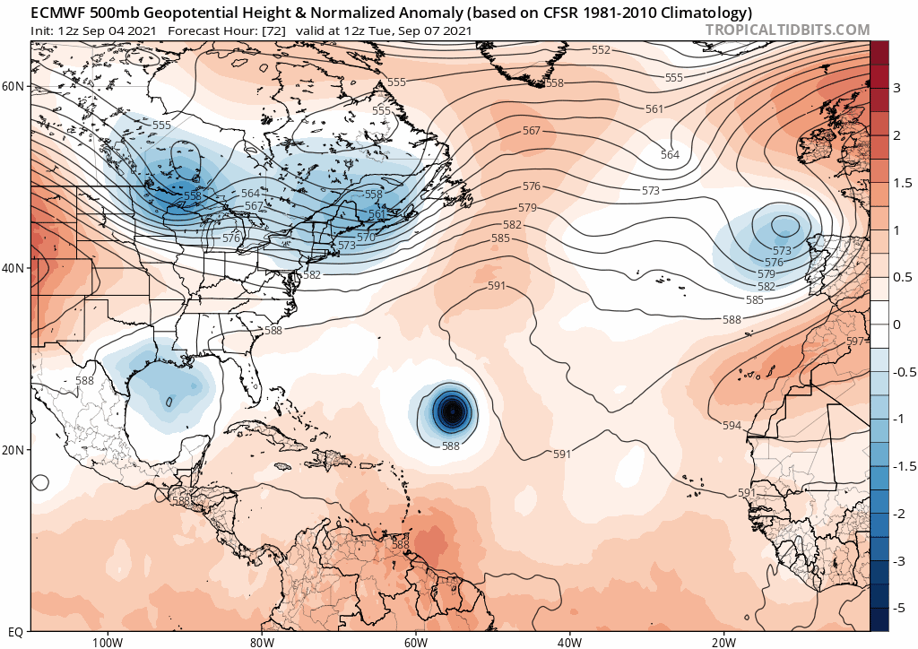
Do as you will with this, and I hope I'm capturing the correct correlation, please let me know if there is a better dynamic for analysis, but I always enjoy comparing UL/ML imagery to model runs and correlate that with NHC updates(speed/strength/direction)

Also here is a longer loop of the MLWV over the last few days..https://weather.cod.edu/satrad/?parms=g ... =undefined
and you can see getting towards the end that ULL building in and pushing NE from 25-30N/70-65W is that what will influence a more WNW/NNW pull, on the contrary I feel that watching this loop it is possible to see a cut off sooner rather than later judging by the speed that ridge is moving over the S IMAO obviously
0 likes
Once I see the REDS and GREENS Converge on a Base Velocity. ... I'm There!!
This is NOT an Official Forecast....Just my Opinion. For official information, please refer to the NHC and NWS products.
HIGHLIGHTS : '13 El Reno Tornado : 2013 Storm Chaser Tour, Joaquin; SC flood event, Matthew '16, Lowcountry Snow storm Jan '18
This is NOT an Official Forecast....Just my Opinion. For official information, please refer to the NHC and NWS products.
HIGHLIGHTS : '13 El Reno Tornado : 2013 Storm Chaser Tour, Joaquin; SC flood event, Matthew '16, Lowcountry Snow storm Jan '18
-
MJGarrison
- Tropical Storm

- Posts: 128
- Joined: Wed Aug 30, 2017 7:26 pm
Re: ATL: LARRY - Models
Kohlecane wrote:Do as you will with this, and I hope I'm capturing the correct correlation, please let me know if there is a better dynamic for analysis, but I always enjoy comparing UL/ML imagery to model runs and correlate that with NHC updates(speed/strength/direction)
Also here is a longer loop of the MLWV over the last few days..https://weather.cod.edu/satrad/?parms=g ... =undefined
and you can see getting towards the end that ULL building in and pushing NE from 25-30N/70-65W is that what will influence a more WNW/NNW pull, on the contrary I feel that watching this loop it is possible to see a cut off sooner rather than later judging by the speed that ridge is moving over the S IMAO obviously
I think for a more apples to apples comparison you might look at the gfs mid level humidity chart. The satellite band you have selected is mid level water vapor.
Sent from my iPad using Tapatalk
2 likes
-
RevanTheJedi96
- Tropical Storm
- Posts: 106
- Joined: Wed Sep 01, 2021 10:40 am
Re: ATL: LARRY - Models
How do you guys feel about Larry modeling? I think that the Westward shifts are stabilizing and all models keep showing a strong trough taking Larry OTS.
Unless this trough gets modeled differently I have a very hard time seeing Larry being anything more than a Bermuda/Atlantic Canada threat worst case scenario.
Unless this trough gets modeled differently I have a very hard time seeing Larry being anything more than a Bermuda/Atlantic Canada threat worst case scenario.
3 likes
Re: ATL: LARRY - Models
12Z UKMET: strongest yet (920mb!!) 250 miles E of Bermuda:
HURRICANE LARRY ANALYSED POSITION : 14.5N 40.1W
ATCF IDENTIFIER : AL122021
LEAD CENTRAL MAXIMUM WIND
VERIFYING TIME TIME POSITION PRESSURE (MB) SPEED (KNOTS)
-------------- ---- -------- ------------- -------------
1200UTC 03.09.2021 0 14.5N 40.1W 982 55
0000UTC 04.09.2021 12 15.5N 42.7W 981 58
1200UTC 04.09.2021 24 16.7N 45.4W 982 55
0000UTC 05.09.2021 36 17.8N 47.6W 980 59
1200UTC 05.09.2021 48 19.4N 49.7W 976 63
0000UTC 06.09.2021 60 21.1N 51.5W 970 67
1200UTC 06.09.2021 72 22.4N 53.5W 960 73
0000UTC 07.09.2021 84 23.6N 55.1W 949 88
1200UTC 07.09.2021 96 25.0N 56.9W 946 94
0000UTC 08.09.2021 108 26.6N 58.3W 928 105
1200UTC 08.09.2021 120 28.8N 59.7W 927 105
0000UTC 09.09.2021 132 31.4N 60.7W 920 110
1200UTC 09.09.2021 144 34.4N 61.1W 922 107
0 likes
Personal Forecast Disclaimer:
The posts in this forum are NOT official forecasts and should not be used as such. They are just the opinion of the poster and may or may not be backed by sound meteorological data. They are NOT endorsed by any professional institution or storm2k.org. For official information, please refer to the NHC and NWS products.
The posts in this forum are NOT official forecasts and should not be used as such. They are just the opinion of the poster and may or may not be backed by sound meteorological data. They are NOT endorsed by any professional institution or storm2k.org. For official information, please refer to the NHC and NWS products.
-
Stormybajan

- Category 1

- Posts: 428
- Joined: Thu May 20, 2021 3:21 pm
- Location: Windward Islands
Re: ATL: LARRY - Models
12z euro out to 144 hours looking like its heading straight for Bermuda ...
1 likes
Sad West Indies and Manchester United fan ⚽️
-
Iceresistance

- Category 5
- Posts: 8910
- Age: 20
- Joined: Sat Oct 10, 2020 9:45 am
- Location: Tecumseh, OK/Norman, OK
Re: ATL: LARRY - Models
12z Euro is stronger than the 12z GFS, think about that one . . .
1 likes
Bill 2015 & Beta 2020
Winter 2020-2021
All observations are in Tecumseh, OK unless otherwise noted.
Winter posts are focused mainly for Oklahoma & Texas.
Take any of my forecasts with a grain of salt, refer to the NWS, SPC, and NHC for official information
Never say Never with weather! Because ANYTHING is possible!
Winter 2020-2021
All observations are in Tecumseh, OK unless otherwise noted.
Winter posts are focused mainly for Oklahoma & Texas.
Take any of my forecasts with a grain of salt, refer to the NWS, SPC, and NHC for official information
Never say Never with weather! Because ANYTHING is possible!

Re: ATL: LARRY - Models
Iceresistance wrote:12z Euro is stronger than the 12z GFS, think about that one . . .
As the saying goes "When GFS bombs out wait for the next model run, it's probably gonna be okay. When the euro bombs out pack your stuff and leave right away". (just joking of course
1 likes

Re: ATL: LARRY - Models
Zonacane wrote:Look forward to coming into this thread Friday with Larry modeled to be in the Hebert Box
Not quite yet, but very close.
0 likes
-
PavelGaborik
- Tropical Depression

- Posts: 81
- Joined: Thu Oct 06, 2016 11:13 pm
Re: ATL: LARRY - Models
Bermuda definitely needs to keep a close eye on Larry.
Nova Scotia is looking less likely down the line, Newfoundland could still potentially receive a strike.
Nova Scotia is looking less likely down the line, Newfoundland could still potentially receive a strike.
1 likes
-
AtlanticWind
- S2K Supporter
- Posts: 1805
- Age: 65
- Joined: Sun Aug 08, 2004 9:57 pm
- Location: Plantation,Fla
Re: ATL: LARRY - Models
Did anyone see the 12z Euro at 240 hours?
It has Larry in approaching Europe as some type of HUGE hybrid storm at 958 mb.
Is that really possible?
No other models show anything like that.
Seems to turn into this massive cyclone, hope thats some model glitch.
It has Larry in approaching Europe as some type of HUGE hybrid storm at 958 mb.
Is that really possible?
No other models show anything like that.
Seems to turn into this massive cyclone, hope thats some model glitch.
0 likes

Re: ATL: LARRY - Models
Latest UK has caught my eye but what are the chances really?

5 likes
ヤンデレ女が寝取られるているのを見たい!!!
ECMWF ensemble NWPAC plots: https://ecmwfensnwpac.imgbb.com/
Multimodel NWPAC plots: https://multimodelnwpac.imgbb.com/
GFS Ensemble NWPAC plots (16 & 35 day forecast): https://gefsnwpac.imgbb.com/
Plots updated automatically
ECMWF ensemble NWPAC plots: https://ecmwfensnwpac.imgbb.com/
Multimodel NWPAC plots: https://multimodelnwpac.imgbb.com/
GFS Ensemble NWPAC plots (16 & 35 day forecast): https://gefsnwpac.imgbb.com/
Plots updated automatically
-
gatorcane

- S2K Supporter
- Posts: 23499
- Age: 46
- Joined: Sun Mar 13, 2005 3:54 pm
- Location: Boca Raton, FL
Re: ATL: LARRY - Models
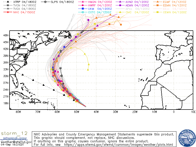
Wow very quiet model thread which makes sense given the model tracks. This post is just the 5th post in 24 hours in this thread. The Euro says “adios” with a fish track:
0 likes
-
Extratropical94

- Professional-Met

- Posts: 3535
- Age: 29
- Joined: Wed Oct 20, 2010 6:36 am
- Location: Hamburg, Germany
- Contact:
Re: ATL: LARRY - Models
AtlanticWind wrote:Did anyone see the 12z Euro at 240 hours?
It has Larry in approaching Europe as some type of HUGE hybrid storm at 958 mb.
Is that really possible?
No other models show anything like that.
Seems to turn into this massive cyclone, hope thats some model glitch.
Quite rare, but not impossible. The lowest recorded pressure in Ireland in September is 957mb, actually. Although usually occuring later in the year, some of the fall/winter storms up here dip into the 950s or even lower before moving over continental Europe
4 likes
54° 11' 59'' N, 9° 9' 20'' E
Boomer Sooner!
Go Broncos! Go Cards! Go Niners!
- Daniel
Boomer Sooner!
Go Broncos! Go Cards! Go Niners!
- Daniel

Re: ATL: LARRY - Models
The 12z nav gem is well pretty crazy with pressure and looks like landfall in Nova Scotia , obviously its a outlier
0 likes
Re: ATL: LARRY - Models
12Z UKMET: 915 mb just 100 miles east of Bermuda!
HURRICANE LARRY ANALYSED POSITION : 19.0N 49.5W
ATCF IDENTIFIER : AL122021
LEAD CENTRAL MAXIMUM WIND
VERIFYING TIME TIME POSITION PRESSURE (MB) SPEED (KNOTS)
-------------- ---- -------- ------------- -------------
1200UTC 05.09.2021 0 19.0N 49.5W 933 106
0000UTC 06.09.2021 12 20.5N 51.4W 942 95
1200UTC 06.09.2021 24 21.7N 53.2W 931 106
0000UTC 07.09.2021 36 22.8N 54.6W 929 110
1200UTC 07.09.2021 48 24.1N 56.3W 919 113
0000UTC 08.09.2021 60 25.8N 57.7W 916 116
1200UTC 08.09.2021 72 27.5N 59.7W 918 118
0000UTC 09.09.2021 84 29.5N 61.7W 918 114
1200UTC 09.09.2021 96 31.9N 63.3W 915 116
0000UTC 10.09.2021 108 35.7N 63.3W 925 105
1200UTC 10.09.2021 120 40.8N 61.2W 929 105
0000UTC 11.09.2021 132 46.5N 55.5W 943 85
1200UTC 11.09.2021 144 52.3N 48.3W 971 46
0 likes
Personal Forecast Disclaimer:
The posts in this forum are NOT official forecasts and should not be used as such. They are just the opinion of the poster and may or may not be backed by sound meteorological data. They are NOT endorsed by any professional institution or storm2k.org. For official information, please refer to the NHC and NWS products.
The posts in this forum are NOT official forecasts and should not be used as such. They are just the opinion of the poster and may or may not be backed by sound meteorological data. They are NOT endorsed by any professional institution or storm2k.org. For official information, please refer to the NHC and NWS products.
-
TheDreamTraveler

- Category 2

- Posts: 633
- Joined: Sun Aug 22, 2010 3:10 am
- Location: PA
Re: ATL: LARRY - Models
Newfoundland is still at risk of a landfall so keep an eye if you're there

0 likes
Who is online
Users browsing this forum: No registered users and 22 guests