ATL: LARRY - Models

Moderator: S2k Moderators

Message
Author
User avatar
aspen
Category 5
Category 5
Posts: 8057
Joined: Sat Oct 12, 2019 7:10 pm
Location: Connecticut, USA

Re: ATL: LARRY - Models

#121 Postby aspen » Wed Sep 01, 2021 5:28 pm

Blown Away wrote:18z GFS is @1 degree S and 5 degrees W compared to 06z this morning. Fortunately no matter how much SW adjustment, it doesn’t appear NE Caribbean is in play at this point.

If a ridge comes to block Larry while it’s that far SW, it won’t be the Caribbean that’ll have to worry.

Seems like every single model run, we’re seeing yet another SW shift. There has to be a point where any further SW is impossible. I also agree that the Caribbean will probably be safe from this — at the most, a very close call like Jose — and Larry won’t end up nearly as far SW as an Irma-like track.
5 likes   
Irene '11 Sandy '12 Hermine '16 5/15/2018 Derecho Fay '20 Isaias '20 Elsa '21 Henri '21 Ida '21

I am only a meteorology enthusiast who knows a decent amount about tropical cyclones. Look to the professional mets, the NHC, or your local weather office for the best information.

User avatar
Category5Kaiju
Category 5
Category 5
Posts: 3357
Age: 22
Joined: Thu Dec 24, 2020 12:45 pm
Location: Seattle

Re: ATL: LARRY - Models

#122 Postby Category5Kaiju » Wed Sep 01, 2021 5:45 pm

Some of the latest GEPS and GEFS ensembles have me stunned to say the least. They actually bring Larry in as a potent cyclone into the Carolinas or Georgia. I'm definitely not writing this storm off at this point as the trends have been somewhat unnerving to me, and I am keeping an eye on any additional westward shifts with myself being in coastal Virginia. I was more than happy to track a powerful fish storm, but as of now there are doubts I have that everything with Larry will be as simple as just turning out to sea harmlessly.
5 likes   
Unless explicitly stated, all information covered in my posts is based on my opinions and observations. Please refer to a professional meteorologist or an accredited weather research agency otherwise, especially if serious decisions must be made in the event of a potentially life-threatening tropical storm or hurricane.

User avatar
Blown Away
S2K Supporter
S2K Supporter
Posts: 9861
Joined: Wed May 26, 2004 6:17 am

Re: ATL: LARRY - Models

#123 Postby Blown Away » Wed Sep 01, 2021 5:54 pm

Category5Kaiju wrote:Some of the latest GEPS and GEFS ensembles have me stunned to say the least. They actually bring Larry in as a potent cyclone into the Carolinas or Georgia. I'm definitely not writing this storm off at this point as the trends have been somewhat unnerving to me, and I am keeping an eye on any additional westward shifts with myself being in coastal Virginia. I was more than happy to track a powerful fish storm, but as of now there are doubts I have that everything with Larry will be as simple as just turning out to sea harmlessly.

Can you post the graphic?
0 likes   
Hurricane Eye Experience: David 79, Irene 99, Frances 04, Jeanne 04, Wilma 05...
Hurricane Brush Experience: Andrew 92, Erin 95, Floyd 99, Matthew 16, Irma 17, Ian 22, Nicole 22…

User avatar
Category5Kaiju
Category 5
Category 5
Posts: 3357
Age: 22
Joined: Thu Dec 24, 2020 12:45 pm
Location: Seattle

Re: ATL: LARRY - Models

#124 Postby Category5Kaiju » Wed Sep 01, 2021 6:27 pm

Blown Away wrote:
Category5Kaiju wrote:Some of the latest GEPS and GEFS ensembles have me stunned to say the least. They actually bring Larry in as a potent cyclone into the Carolinas or Georgia. I'm definitely not writing this storm off at this point as the trends have been somewhat unnerving to me, and I am keeping an eye on any additional westward shifts with myself being in coastal Virginia. I was more than happy to track a powerful fish storm, but as of now there are doubts I have that everything with Larry will be as simple as just turning out to sea harmlessly.

Can you post the graphic?


I am not personally sure how to show an animated trend on S2K (and I’ll figure it out when I have more time), but you could access the ensembles on Tropical Tidbits; there’s a clear SW trend in many of the guidances, and I really hope that does not continue because eventually land will come into play
0 likes   
Unless explicitly stated, all information covered in my posts is based on my opinions and observations. Please refer to a professional meteorologist or an accredited weather research agency otherwise, especially if serious decisions must be made in the event of a potentially life-threatening tropical storm or hurricane.

User avatar
Category5Kaiju
Category 5
Category 5
Posts: 3357
Age: 22
Joined: Thu Dec 24, 2020 12:45 pm
Location: Seattle

Re: ATL: LARRY - Models

#125 Postby Category5Kaiju » Wed Sep 01, 2021 6:35 pm

Category5Kaiju wrote:Some of the latest GEPS and GEFS ensembles have me stunned to say the least. They actually bring Larry in as a potent cyclone into the Carolinas or Georgia. I'm definitely not writing this storm off at this point as the trends have been somewhat unnerving to me, and I am keeping an eye on any additional westward shifts with myself being in coastal Virginia. I was more than happy to track a powerful fish storm, but as of now there are doubts I have that everything with Larry will be as simple as just turning out to sea harmlessly.
Category5Kaiju wrote:
Blown Away wrote:
Category5Kaiju wrote:Some of the latest GEPS and GEFS ensembles have me stunned to say the least. They actually bring Larry in as a potent cyclone into the Carolinas or Georgia. I'm definitely not writing this storm off at this point as the trends have been somewhat unnerving to me, and I am keeping an eye on any additional westward shifts with myself being in coastal Virginia. I was more than happy to track a powerful fish storm, but as of now there are doubts I have that everything with Larry will be as simple as just turning out to sea harmlessly.

Can you post the graphic?


I am not personally sure how to show an animated trend on S2K (and I’ll figure it out when I have more time), but you could access the ensembles on Tropical Tidbits; there’s a clear SW trend in many of the guidances, and I really hope that does not continue because eventually land will come into play


Also correction: it's the GEPS not the GEFS that notably have some ensembles that hit the SE US Coast, my apologies. The GEFS still show a recurve, but every run seems to be slightly more SW
0 likes   
Unless explicitly stated, all information covered in my posts is based on my opinions and observations. Please refer to a professional meteorologist or an accredited weather research agency otherwise, especially if serious decisions must be made in the event of a potentially life-threatening tropical storm or hurricane.

User avatar
Blown Away
S2K Supporter
S2K Supporter
Posts: 9861
Joined: Wed May 26, 2004 6:17 am

Re: ATL: LARRY - Models

#126 Postby Blown Away » Wed Sep 01, 2021 6:47 pm

18z HWRF... Significant SW shift at 96 hours...
0 likes   
Hurricane Eye Experience: David 79, Irene 99, Frances 04, Jeanne 04, Wilma 05...
Hurricane Brush Experience: Andrew 92, Erin 95, Floyd 99, Matthew 16, Irma 17, Ian 22, Nicole 22…

AutoPenalti
Category 5
Category 5
Posts: 3949
Age: 27
Joined: Mon Aug 17, 2015 4:16 pm
Location: Ft. Lauderdale, Florida

Re: ATL: LARRY - Models

#127 Postby AutoPenalti » Wed Sep 01, 2021 7:00 pm

Forward speed will be an issue as well. HWRF seems to be showcasing this for the time being.
0 likes   
The posts in this forum are NOT official forecasts and should not be used as such. They are just the opinion of the poster and may or may not be backed by sound meteorological data. They are NOT endorsed by any professional institution or STORM2K. For official information, please refer to products from the NHC and NWS.


Model Runs Cheat Sheet:
GFS (5:30 AM/PM, 11:30 AM/PM)
HWRF, GFDL, UKMET, NAVGEM (6:30-8:00 AM/PM, 12:30-2:00 AM/PM)
ECMWF (1:45 AM/PM)

TCVN
is a weighted averaged

User avatar
Ubuntwo
Category 5
Category 5
Posts: 1089
Age: 30
Joined: Thu Oct 05, 2017 10:41 pm

Re: ATL: LARRY - Models

#128 Postby Ubuntwo » Wed Sep 01, 2021 7:04 pm

Category5Kaiju wrote:Some of the latest GEPS and GEFS ensembles have me stunned to say the least. They actually bring Larry in as a potent cyclone into the Carolinas or Georgia. I'm definitely not writing this storm off at this point as the trends have been somewhat unnerving to me, and I am keeping an eye on any additional westward shifts with myself being in coastal Virginia. I was more than happy to track a powerful fish storm, but as of now there are doubts I have that everything with Larry will be as simple as just turning out to sea harmlessly.

The 18z GEFS shifted west but still no CONUS landfalls. Two members of the 12z GEPS made landfall on the CONUS. Worth keeping an eye on, but nothing to freak out about yet.
0 likes   
Kendall -> SLO -> PBC

Memorable Storms: Katrina (for its Florida landfall...) Wilma Matthew Irma

User avatar
Ubuntwo
Category 5
Category 5
Posts: 1089
Age: 30
Joined: Thu Oct 05, 2017 10:41 pm

Re: ATL: LARRY - Models

#129 Postby Ubuntwo » Wed Sep 01, 2021 7:05 pm

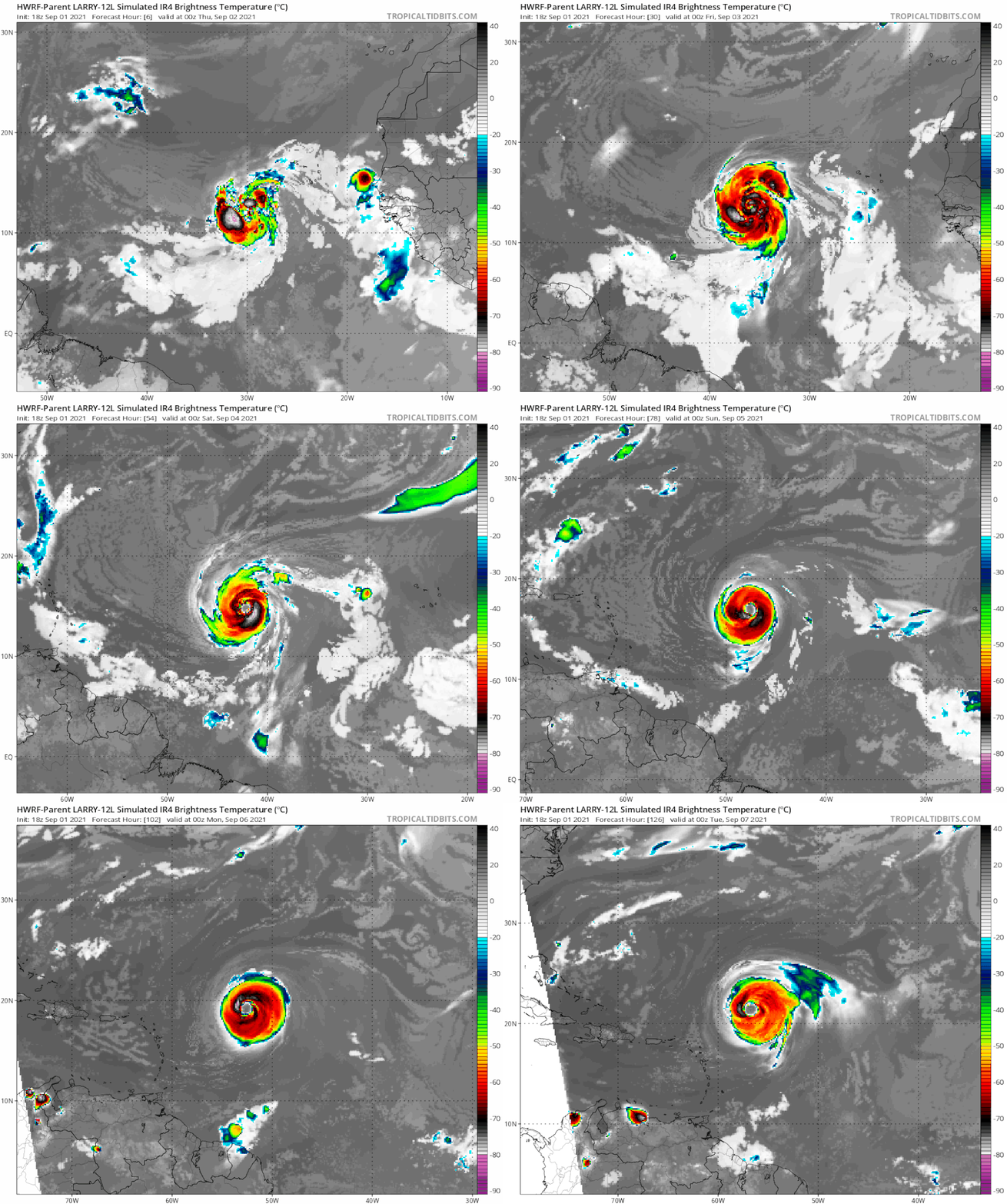
The 18z HWRF depicts an eyewall replacement cycle before Larry starts clearing a large eye and transitioning to annular.
0 likes   
Kendall -> SLO -> PBC

Memorable Storms: Katrina (for its Florida landfall...) Wilma Matthew Irma

User avatar
gatorcane
S2K Supporter
S2K Supporter
Posts: 23499
Age: 46
Joined: Sun Mar 13, 2005 3:54 pm
Location: Boca Raton, FL

Re: ATL: LARRY - Models

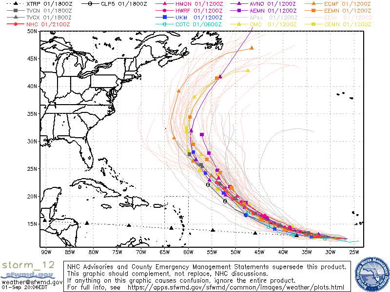
#130 Postby gatorcane » Wed Sep 01, 2021 7:18 pm

Strong recurve signal still:

Image
1 likes   

User avatar
Blown Away
S2K Supporter
S2K Supporter
Posts: 9861
Joined: Wed May 26, 2004 6:17 am

Re: ATL: LARRY - Models

#131 Postby Blown Away » Wed Sep 01, 2021 7:19 pm

18z HWRF... @1 degree S and 3-4 degrees W of previous runs... Closing in on the 20N/60W mark... Still likely showing a recurve just NE of the Caribbean at 126 hours...

@130 mph large hurricane...
0 likes   
Hurricane Eye Experience: David 79, Irene 99, Frances 04, Jeanne 04, Wilma 05...
Hurricane Brush Experience: Andrew 92, Erin 95, Floyd 99, Matthew 16, Irma 17, Ian 22, Nicole 22…

sma10
Category 5
Category 5
Posts: 1709
Joined: Tue Aug 02, 2005 1:13 pm

Re: ATL: LARRY - Models

#132 Postby sma10 » Wed Sep 01, 2021 7:21 pm

gatorcane wrote:Strong recurve signal still:

https://i.postimg.cc/qBhbW454/storm-12-ens.gif


Yes, there might be a bit of shifting to the SW run-to-run, but so long as there is consistent troughiness in the NE on days 6-10, there is little else for Larry to go
1 likes   

User avatar
Blown Away
S2K Supporter
S2K Supporter
Posts: 9861
Joined: Wed May 26, 2004 6:17 am

Re: ATL: LARRY - Models

#133 Postby Blown Away » Wed Sep 01, 2021 7:27 pm

gatorcane wrote:Strong recurve signal still:

https://i.postimg.cc/qBhbW454/storm-12-ens.gif


Agree that is most likely outcome, but the consistent large SW shifting in the model runs has been ongoing all day long...
0 likes   
Hurricane Eye Experience: David 79, Irene 99, Frances 04, Jeanne 04, Wilma 05...
Hurricane Brush Experience: Andrew 92, Erin 95, Floyd 99, Matthew 16, Irma 17, Ian 22, Nicole 22…

User avatar
Hurricaneman
Category 5
Category 5
Posts: 7281
Age: 43
Joined: Tue Aug 31, 2004 3:24 pm
Location: central florida

Re: ATL: LARRY - Models

#134 Postby Hurricaneman » Wed Sep 01, 2021 7:35 pm

Blown Away wrote:18z HWRF... @1 degree S and 3-4 degrees W of previous runs... Closing in on the 20N/60W mark... Still likely showing a recurve just NE of the Caribbean at 126 hours...

@130 mph large hurricane...


True it recurves, but the location of the recurve and direction could make the difference and any SW shifts from here could put the NE lesser Antilles in harms way
0 likes   

User avatar
Hurricaneman
Category 5
Category 5
Posts: 7281
Age: 43
Joined: Tue Aug 31, 2004 3:24 pm
Location: central florida

Re: ATL: LARRY - Models

#135 Postby Hurricaneman » Wed Sep 01, 2021 7:36 pm

Blown Away wrote:
gatorcane wrote:Strong recurve signal still:

https://i.postimg.cc/qBhbW454/storm-12-ens.gif


Agree that is most likely outcome, but the consistent large SW shifting in the model runs has been ongoing all day long...


That’s my fear for the NE lesser Antilles
1 likes   

tomatkins
Tropical Storm
Tropical Storm
Posts: 220
Joined: Wed Sep 05, 2018 2:11 pm

Re: ATL: LARRY - Models

#136 Postby tomatkins » Wed Sep 01, 2021 7:36 pm

gatorcane wrote:Strong recurve signal still:

https://i.postimg.cc/qBhbW454/storm-12-ens.gif


Until right this minute I never really noticed that Bermuda is just a little east of the eastern tip of Maine. I always imagine it being way out in the ocean, and only 20 miles further from block island than from hatteras.
1 likes   

User avatar
gatorcane
S2K Supporter
S2K Supporter
Posts: 23499
Age: 46
Joined: Sun Mar 13, 2005 3:54 pm
Location: Boca Raton, FL

Re: ATL: LARRY - Models

#137 Postby gatorcane » Wed Sep 01, 2021 8:23 pm

Looks like Larry becomes annular on the HWRF: :eek:

Image
5 likes   

User avatar
aspen
Category 5
Category 5
Posts: 8057
Joined: Sat Oct 12, 2019 7:10 pm
Location: Connecticut, USA

Re: ATL: LARRY - Models

#138 Postby aspen » Wed Sep 01, 2021 8:27 pm

The 00z model track guidance might warrant yet another SW shift for the NHC forecast track. Every model run makes a completely harmless recurve less and less likely. At the very least, this could be a problem for Bermuda.
3 likes   
Irene '11 Sandy '12 Hermine '16 5/15/2018 Derecho Fay '20 Isaias '20 Elsa '21 Henri '21 Ida '21

I am only a meteorology enthusiast who knows a decent amount about tropical cyclones. Look to the professional mets, the NHC, or your local weather office for the best information.

Sciencerocks
Category 5
Category 5
Posts: 7286
Age: 38
Joined: Thu Jul 06, 2017 1:51 am

Re: ATL: LARRY - Models

#139 Postby Sciencerocks » Wed Sep 01, 2021 8:29 pm

gatorcane wrote:Looks like Larry becomes annular on the HWRF: :eek:

https://i.postimg.cc/4NLVb9X5/hwrf-p-sat-IR-12-L-fh6-126.gif


Kind of reminds me of Isabel a little. Isabel tracked west-southwest in the eastern Atlantic and had very much the same model thinking.
0 likes   

User avatar
Blown Away
S2K Supporter
S2K Supporter
Posts: 9861
Joined: Wed May 26, 2004 6:17 am

Re: ATL: LARRY - Models

#140 Postby Blown Away » Wed Sep 01, 2021 9:10 pm

gatorcane wrote:Looks like Larry becomes annular on the HWRF: :eek:

https://i.postimg.cc/4NLVb9X5/hwrf-p-sat-IR-12-L-fh6-126.gif


How cool is that!! Odd to have the HWRF as the Left outlier...
0 likes   
Hurricane Eye Experience: David 79, Irene 99, Frances 04, Jeanne 04, Wilma 05...
Hurricane Brush Experience: Andrew 92, Erin 95, Floyd 99, Matthew 16, Irma 17, Ian 22, Nicole 22…


Return to “2021”

Who is online

Users browsing this forum: No registered users and 69 guests