ATL: LARRY - Models
Moderator: S2k Moderators
-
cycloneye

- Admin

- Posts: 139025
- Age: 67
- Joined: Thu Oct 10, 2002 10:54 am
- Location: San Juan, Puerto Rico
ATL: LARRY - Models
Only model runs.
0 likes
Visit the Caribbean-Central America Weather Thread where you can find at first post web cams,radars
and observations from Caribbean basin members Click Here
and observations from Caribbean basin members Click Here
-
AlphaToOmega
- Category 5

- Posts: 1448
- Joined: Sat Jun 26, 2021 10:51 am
- Location: Somewhere in Massachusetts


-
eastcoastFL

- Category 5
- Posts: 3437
- Age: 42
- Joined: Thu Apr 12, 2007 12:29 pm
- Location: Palm City, FL
Re: ATL: INVEST 90L - Models
Zonacane wrote:Repeat after me: Not. Guaranteed. To. Recurve
Yup. Globals looked to be trending a little west. Will have to see what they do when a well defined low forms
2 likes
Personal Forecast Disclaimer:
The posts in this forum are NOT official forecast and should not be used as such. They are just the opinion of the poster and may or may not be backed by sound meteorological data. They are NOT endorsed by any professional institution or storm2k.org. For official information, please refer to the NHC and NWS products.
The posts in this forum are NOT official forecast and should not be used as such. They are just the opinion of the poster and may or may not be backed by sound meteorological data. They are NOT endorsed by any professional institution or storm2k.org. For official information, please refer to the NHC and NWS products.
-
cycloneye
- Admin
- Posts: 139025
- Age: 67
- Joined: Thu Oct 10, 2002 10:54 am
- Location: San Juan, Puerto Rico
Re: ATL: INVEST 90L - Models

1 likes
Visit the Caribbean-Central America Weather Thread where you can find at first post web cams,radars
and observations from Caribbean basin members Click Here
and observations from Caribbean basin members Click Here
-
cycloneye
- Admin
- Posts: 139025
- Age: 67
- Joined: Thu Oct 10, 2002 10:54 am
- Location: San Juan, Puerto Rico
Re: ATL: INVEST 90L - Models
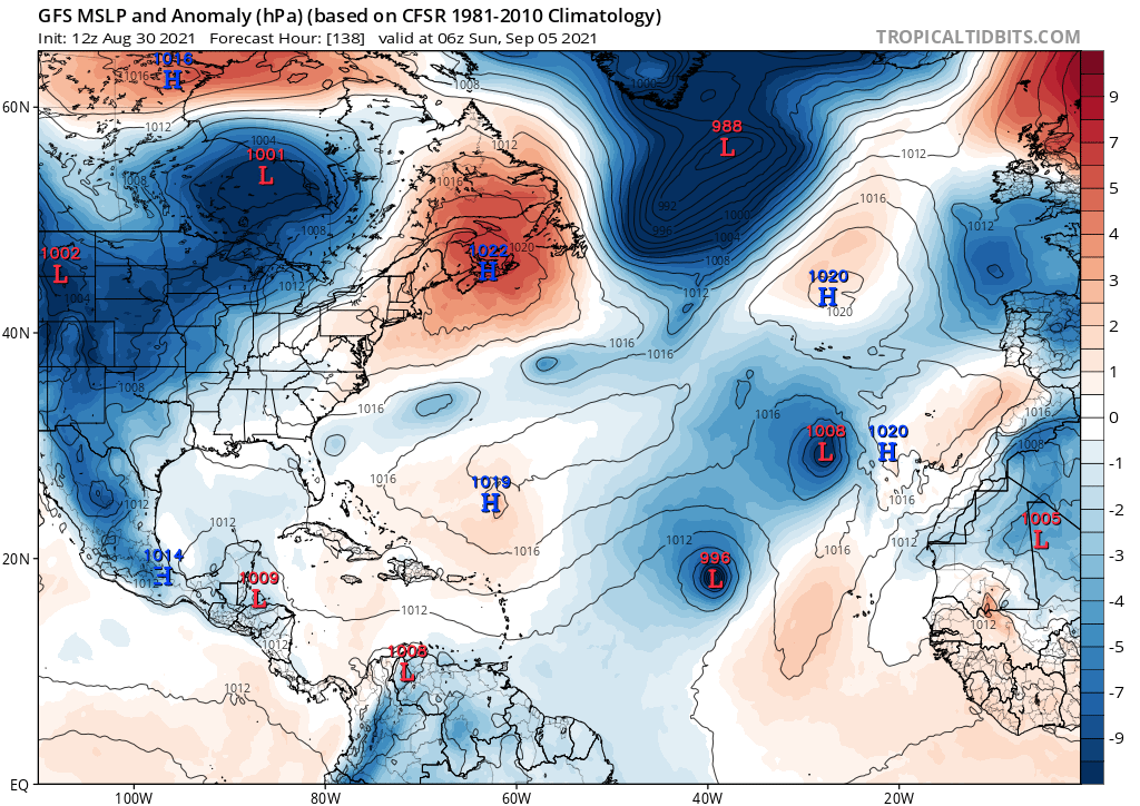
In this 12z run Euro gets closer to Bermuda.

0 likes
Visit the Caribbean-Central America Weather Thread where you can find at first post web cams,radars
and observations from Caribbean basin members Click Here
and observations from Caribbean basin members Click Here
-
AutoPenalti
- Category 5
- Posts: 3949
- Age: 27
- Joined: Mon Aug 17, 2015 4:16 pm
- Location: Ft. Lauderdale, Florida
Re: ATL: INVEST 90L - Models
Zonacane wrote:Repeat after me: Not. Guaranteed. To. Recurve
I was very skeptical in the beginning and continue to do so.
2 likes
The posts in this forum are NOT official forecasts and should not be used as such. They are just the opinion of the poster and may or may not be backed by sound meteorological data. They are NOT endorsed by any professional institution or STORM2K. For official information, please refer to products from the NHC and NWS.
Model Runs Cheat Sheet:
GFS (5:30 AM/PM, 11:30 AM/PM)
HWRF, GFDL, UKMET, NAVGEM (6:30-8:00 AM/PM, 12:30-2:00 AM/PM)
ECMWF (1:45 AM/PM)
TCVN is a weighted averaged
-
Hypercane_Kyle

- Category 5
- Posts: 2899
- Joined: Sat Mar 07, 2015 7:58 pm
- Location: Cape Canaveral, FL
Re: ATL: INVEST 90L - Models
12z GFS is a mess. Has two areas of low pressures tugging 90L north.
This is the Euro's storm. It correctly modeled this nearly two weeks in advance. I knock on the Euro a lot, but here it's done an incredibly impressive job predicting this.
This is the Euro's storm. It correctly modeled this nearly two weeks in advance. I knock on the Euro a lot, but here it's done an incredibly impressive job predicting this.
5 likes
My posts are my own personal opinion, defer to the National Hurricane Center (NHC) and other NOAA products for decision making during hurricane season.
-
Blown Away

- S2K Supporter

- Posts: 9861
- Joined: Wed May 26, 2004 6:17 am
Re: ATL: INVEST 90L - Models

12z EURO... Continues to shift slightly SW, still appears fishy... Look at the size of 90L at 240 hours compared to Ida...
3 likes
Hurricane Eye Experience: David 79, Irene 99, Frances 04, Jeanne 04, Wilma 05...
Hurricane Brush Experience: Andrew 92, Erin 95, Floyd 99, Matthew 16, Irma 17, Ian 22, Nicole 22…
Hurricane Brush Experience: Andrew 92, Erin 95, Floyd 99, Matthew 16, Irma 17, Ian 22, Nicole 22…
-
Blown Away
- S2K Supporter
- Posts: 9861
- Joined: Wed May 26, 2004 6:17 am
Re: ATL: INVEST 90L - Models

First model plot for 90L... Does the Ukmet always start way L of everything else.
0 likes
Hurricane Eye Experience: David 79, Irene 99, Frances 04, Jeanne 04, Wilma 05...
Hurricane Brush Experience: Andrew 92, Erin 95, Floyd 99, Matthew 16, Irma 17, Ian 22, Nicole 22…
Hurricane Brush Experience: Andrew 92, Erin 95, Floyd 99, Matthew 16, Irma 17, Ian 22, Nicole 22…
-
tolakram
- Admin
- Posts: 19165
- Age: 60
- Joined: Sun Aug 27, 2006 8:23 pm
- Location: Florence, KY (name is Mark)
Re: ATL: INVEST 90L - Models
Let's start with the Euro, beeline to Bermuda.

0 likes
M a r k
- - - - -
Join us in chat: Storm2K Chatroom Invite. Android and IOS apps also available.
The posts in this forum are NOT official forecasts and should not be used as such. Posts are NOT endorsed by any professional institution or STORM2K.org. For official information and forecasts, please refer to NHC and NWS products.
-
tolakram
- Admin
- Posts: 19165
- Age: 60
- Joined: Sun Aug 27, 2006 8:23 pm
- Location: Florence, KY (name is Mark)
Re: ATL: INVEST 90L - Models
GFS

0 likes
M a r k
- - - - -
Join us in chat: Storm2K Chatroom Invite. Android and IOS apps also available.
The posts in this forum are NOT official forecasts and should not be used as such. Posts are NOT endorsed by any professional institution or STORM2K.org. For official information and forecasts, please refer to NHC and NWS products.
- - - - -
Join us in chat: Storm2K Chatroom Invite. Android and IOS apps also available.
The posts in this forum are NOT official forecasts and should not be used as such. Posts are NOT endorsed by any professional institution or STORM2K.org. For official information and forecasts, please refer to NHC and NWS products.
-
tolakram
- Admin
- Posts: 19165
- Age: 60
- Joined: Sun Aug 27, 2006 8:23 pm
- Location: Florence, KY (name is Mark)
Re: ATL: INVEST 90L - Models
CMC

0 likes
M a r k
- - - - -
Join us in chat: Storm2K Chatroom Invite. Android and IOS apps also available.
The posts in this forum are NOT official forecasts and should not be used as such. Posts are NOT endorsed by any professional institution or STORM2K.org. For official information and forecasts, please refer to NHC and NWS products.
- - - - -
Join us in chat: Storm2K Chatroom Invite. Android and IOS apps also available.
The posts in this forum are NOT official forecasts and should not be used as such. Posts are NOT endorsed by any professional institution or STORM2K.org. For official information and forecasts, please refer to NHC and NWS products.
-
cheezyWXguy

- Category 5
- Posts: 5528
- Joined: Mon Feb 13, 2006 12:29 am
- Location: Dallas, TX
Re: ATL: INVEST 90L - Models
Really not a fan of that ridge building in at the end. Good thing it’s so far out.
2 likes
-
SEASON_CANCELED

- Category 3

- Posts: 887
- Joined: Mon Jul 06, 2009 5:17 am
- Location: 8 Bit Charlie Sheen
Re: ATL: INVEST 90L - Models
Looks like a fish spinner....but will keep an eye out
0 likes
i am a big stupid ugly moron with an ugly face and a big butt and my butt stinks and i like to kiss my own butt
-
SouthFLTropics

- Category 5
- Posts: 4156
- Age: 48
- Joined: Thu Aug 14, 2003 8:04 am
- Location: Port St. Lucie, Florida
Re: ATL: INVEST 90L - Models
All of the models seem to be onboard for this one and make it significant. Assuming this doesn't continue chugging west and stays a fish, I look forward to seeing what kind of potential this one has. I'm sure it is going to rack up some ACE.
5 likes
Fourth Generation Floridian...With lots of storm knowledge passed down from my elders...
Personal Storm History: David 79, Andrew 92, Erin 95, Floyd 99, Irene 99, Frances 04, Jeanne 04, Wilma 05, Matthew 16, Irma 17
Personal Storm History: David 79, Andrew 92, Erin 95, Floyd 99, Irene 99, Frances 04, Jeanne 04, Wilma 05, Matthew 16, Irma 17
-
gatorcane

- S2K Supporter
- Posts: 23499
- Age: 46
- Joined: Sun Mar 13, 2005 3:54 pm
- Location: Boca Raton, FL
Re: ATL: INVEST 90L - Models
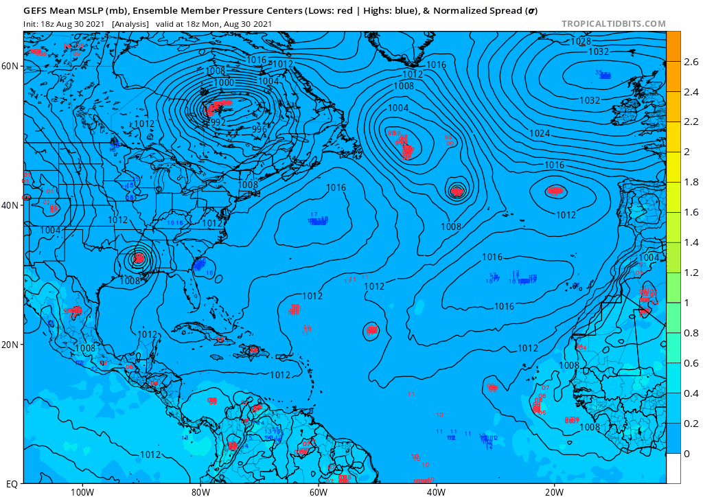
Looks like a strong fish signal thankfully, but we will need to wait a bit longer to know for sure and there is always Bermuda also:
0 likes
-
cheezyWXguy
- Category 5
- Posts: 5528
- Joined: Mon Feb 13, 2006 12:29 am
- Location: Dallas, TX
Re: ATL: INVEST 90L - Models
gatorcane wrote:Looks like a strong fish signal thankfully, but we will need to wait a bit longer to know for sure and there is always Bermuda also:
https://i.postimg.cc/qvpLLG0W/gfs-ememb-lowlocs-atl-fh0-168.gif
Problem is the gefs seems heavily influenced by the idea of 2 storms forming out of this region, which probably isn’t likely. I still ultimately think this will probably be a fish if it doesn’t run into Bermuda or scrape Canada, but I agree more with the euro’s westward evolution over the next 5-7 days.
0 likes
Re: ATL: INVEST 90L - Models
cheezyWXguy wrote:gatorcane wrote:Looks like a strong fish signal thankfully, but we will need to wait a bit longer to know for sure and there is always Bermuda also:
https://i.postimg.cc/qvpLLG0W/gfs-ememb-lowlocs-atl-fh0-168.gif
Problem is the gefs seems heavily influenced by the idea of 2 storms forming out of this region, which probably isn’t likely. I still ultimately think this will probably be a fish if it doesn’t run into Bermuda or scrape Canada, but I agree more with the euro’s westward evolution over the next 5-7 days.
Operational GFS sure does take its sweet time with Larry - still has it out in the central Atlantic on day 16 heading towards the Azores. Its a fish storm that is determined to take out all the fish.
0 likes
Re: ATL: INVEST 90L - Models
Here is the 18Z EPS at 144 (end of run): All 51 members are still recurving with already a NW to NNW movement by ~hour 120. And this includes those members moving W to WNW pretty far south initially in the eastern Atlantic. Granted, the mean is a bit further west than the prior runs. But still there's more than enough upper troughing coming into the NE US that follows Ida which all serve to keep the WAR quite weak for the next 7-10 days and thus enough steering to allow for a recurve well away from the SE US.
Nothing is ever close to being set in stone this far in advance in the tropics. So, it obviously is still worth monitoring. But I continue to like the odds a lot right now of avoiding the SE US. Besides, a storm named Larry shouldn't be one to fear.
Also, Bermuda, Canada, and even the NE US are in somewhat more danger, especially Bermuda. But that can be addressed later.
1 likes
Personal Forecast Disclaimer:
The posts in this forum are NOT official forecasts and should not be used as such. They are just the opinion of the poster and may or may not be backed by sound meteorological data. They are NOT endorsed by any professional institution or storm2k.org. For official information, please refer to the NHC and NWS products.
The posts in this forum are NOT official forecasts and should not be used as such. They are just the opinion of the poster and may or may not be backed by sound meteorological data. They are NOT endorsed by any professional institution or storm2k.org. For official information, please refer to the NHC and NWS products.
Who is online
Users browsing this forum: No registered users and 35 guests