ATL: MINDY - Post-Tropical - Discussion
Moderator: S2k Moderators
-
Sciencerocks
- Category 5

- Posts: 7282
- Age: 38
- Joined: Thu Jul 06, 2017 1:51 am
-
Iceresistance

- Category 5
- Posts: 8911
- Age: 20
- Joined: Sat Oct 10, 2020 9:45 am
- Location: Tecumseh, OK/Norman, OK
Re: ATL: MINDY - Tropical Storm - Discussion UPDATE = Mindy now at 45 mph
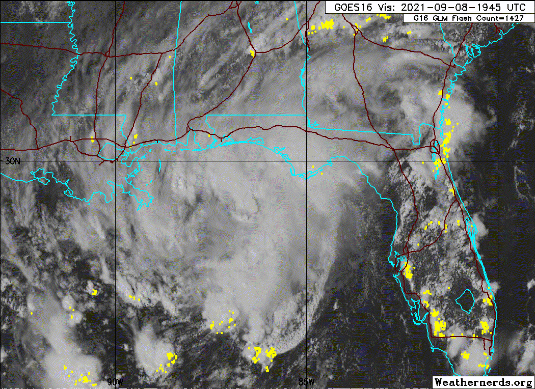
Tropical Storm Mindy Tropical Cyclone Update
NWS National Hurricane Center Miami FL AL132021
500 PM CDT Wed Sep 08 2021
...NOAA BUOY DATA INDICATES THAT MINDY IS A LITTLE STRONGER...
Recent data from NOAA buoy 42036 indicates that the maximum
sustained winds in Mindy are now near 45 mph (75 km/h) with higher
gusts.
SUMMARY OF 500 PM CDT...2200 UTC...INFORMATION
---------------------------------------------------
LOCATION...29.2N 86.1W
ABOUT 75 MI...120 KM WSW OF APALACHICOLA FLORIDA
MAXIMUM SUSTAINED WINDS...45 MPH...75 KM/H
PRESENT MOVEMENT...NE OR 50 DEGREES AT 21 MPH...33 KM/H
MINIMUM CENTRAL PRESSURE...1004 MB...29.65 INCHES
$$
Forecaster Beven
0 likes
Bill 2015 & Beta 2020
Winter 2020-2021
All observations are in Tecumseh, OK unless otherwise noted.
Winter posts are focused mainly for Oklahoma & Texas.
Take any of my forecasts with a grain of salt, refer to the NWS, SPC, and NHC for official information
Never say Never with weather! Because ANYTHING is possible!
Winter 2020-2021
All observations are in Tecumseh, OK unless otherwise noted.
Winter posts are focused mainly for Oklahoma & Texas.
Take any of my forecasts with a grain of salt, refer to the NWS, SPC, and NHC for official information
Never say Never with weather! Because ANYTHING is possible!
-
InfernoFlameCat

- Category 5
- Posts: 1966
- Age: 21
- Joined: Mon Dec 14, 2020 10:52 am
- Location: Buford, GA
Re: ATL: MINDY - Tropical Storm - Discussion
I see a surface circulation but the deep convection is lacking. Still a tc with a well defined outflow. Trough to its north north west could help squeeze out a little bit more wind from Mindy.
0 likes
I am by no means a professional. DO NOT look at my forecasts for official information or make decisions based on what I post.
Goal: to become a registered expert over tropical and subtropical cyclones.
Goal: to become a registered expert over tropical and subtropical cyclones.
-
grapealcoholic
- Category 2

- Posts: 634
- Joined: Tue Aug 10, 2021 3:26 pm
Re: ATL: MINDY - Tropical Storm - Discussion
I wouldn't want to be in the direct path of this thing is all im saying
0 likes
-
cheezyWXguy

- Category 5
- Posts: 5528
- Joined: Mon Feb 13, 2006 12:29 am
- Location: Dallas, TX
Re: ATL: MINDY - Tropical Storm - Discussion
It looks like it’s wrapped up quite a bit since the time of initial upgrade. If those radar velocities approaching 70mph in the SE quad are believable and not just related to range folding, this probably does have circulation related winds that meet the criteria now, instead of just being related to the attendant outflow boundary observed earlier. Agree with Tolakram’s earlier post though, this was likely upgraded at the time to get warnings out earlier, and on the premise that it would intensify.
Still, pre-Sally east of Florida last year would probably have some gripes with not being upgraded to TS on the same premise while exhibiting similar structure and intensity being called a mesovort.
Still, pre-Sally east of Florida last year would probably have some gripes with not being upgraded to TS on the same premise while exhibiting similar structure and intensity being called a mesovort.
5 likes
-
tolakram
- Admin

- Posts: 19165
- Age: 60
- Joined: Sun Aug 27, 2006 8:23 pm
- Location: Florence, KY (name is Mark)
Re: ATL: MINDY - Tropical Storm - Discussion
saved loop

10 likes
M a r k
- - - - -
Join us in chat: Storm2K Chatroom Invite. Android and IOS apps also available.
The posts in this forum are NOT official forecasts and should not be used as such. Posts are NOT endorsed by any professional institution or STORM2K.org. For official information and forecasts, please refer to NHC and NWS products.

Re: ATL: MINDY - Tropical Storm - Discussion
Lots of tree branches that slap the power lines when you get 50 mph gusts so good heads up for the power crews. Not a lot of rain and its moving fast so maybe just the beach communities will lose power.
1 likes

Re: ATL: MINDY - Tropical Storm - Discussion
Mindy has a legit little tight closed circulation, just like the GFS was persistent on having.

6 likes
-
TallyTracker
- Category 2
- Posts: 584
- Joined: Thu Oct 11, 2018 2:46 pm
Re: ATL: MINDY - Tropical Storm - Discussion
The center is looking much better defined on radar. I am interested to see the surface data as Mindy passes Apalachicola. This storm really reminds me of Emily 2017 even more now. Low chance to tropical storm with no warning.
1 likes
Fran '96, Georges '98, Gordon '00, Gabrielle '01, Charley '04, Frances '04, Jeanne '04, Barry '07, Fay '08, Debby '12, Matthew '16, Emily '17, Irma '17, Michael ‘18, Elsa ‘21, Fred ‘21, Mindy ‘21, Nicole ‘22, Idalia ‘23

Re: ATL: MINDY - Tropical Storm - Discussion
TallyTracker wrote:The center is looking much better defined on radar. I am interested to see the surface data as Mindy passes Apalachicola. This storm really reminds me of Emily 2017 even more now. Low chance to tropical storm with no warning.
On its current track, the strongest winds will pass well to the south of Apalachicola.
0 likes
Kendall -> SLO -> PBC
Memorable Storms: Katrina (for its Florida landfall...) Wilma Matthew Irma
Memorable Storms: Katrina (for its Florida landfall...) Wilma Matthew Irma
-
Sciencerocks
- Category 5
- Posts: 7282
- Age: 38
- Joined: Thu Jul 06, 2017 1:51 am
-
Iceresistance
- Category 5
- Posts: 8911
- Age: 20
- Joined: Sat Oct 10, 2020 9:45 am
- Location: Tecumseh, OK/Norman, OK
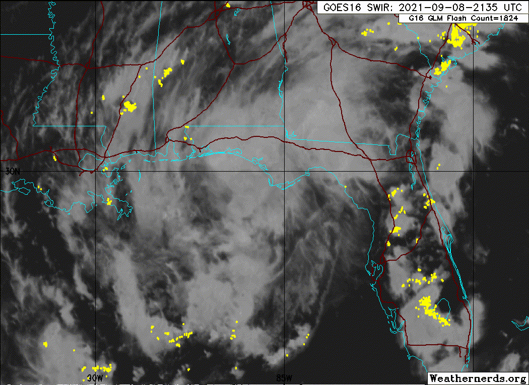
Re: ATL: MINDY - Tropical Storm - Discussion UPDATE = Mindy makes landfall over St. Vincent Island, Florida
Landfall
Tropical Storm Mindy Tropical Cyclone Update
NWS National Hurricane Center Miami FL AL132021
815 PM CDT Wed Sep 08 2021
...CENTER OF MINDY MAKES LANDFALL AT ST. VINCENT ISLAND FLORIDA...
National Weather Service Doppler radar data and surface
observations indicate that the center of Mindy has made landfall
over St. Vincent Island, Florida.
The Tyndall Air Force Base tower south of Apalachicola, Florida,
recently reported sustained winds of 44 mph (70 km/h) and a wind
gust of 55 mph (89 km/h) at an elevation of 115 ft (35 m).
SUMMARY OF 815 PM CDT...0115 UTC...INFORMATION
---------------------------------------------------
LOCATION...29.7N 85.2W
ABOUT 10 MI...15 KM WSW OF APALACHICOLA FLORIDA
MAXIMUM SUSTAINED WINDS...45 MPH...75 KM/H
PRESENT MOVEMENT...NE OR 50 DEGREES AT 21 MPH...33 KM/H
MINIMUM CENTRAL PRESSURE...1004 MB...29.65 INCHES
$$
Forecaster Beven
0 likes
Bill 2015 & Beta 2020
Winter 2020-2021
All observations are in Tecumseh, OK unless otherwise noted.
Winter posts are focused mainly for Oklahoma & Texas.
Take any of my forecasts with a grain of salt, refer to the NWS, SPC, and NHC for official information
Never say Never with weather! Because ANYTHING is possible!
Winter 2020-2021
All observations are in Tecumseh, OK unless otherwise noted.
Winter posts are focused mainly for Oklahoma & Texas.
Take any of my forecasts with a grain of salt, refer to the NWS, SPC, and NHC for official information
Never say Never with weather! Because ANYTHING is possible!
-
SouthernBreeze

- Category 1

- Posts: 284
- Age: 67
- Joined: Tue Aug 31, 2004 4:54 pm
- Location: SC/NC line- on the SC Coast
Re: ATL: MINDY - Tropical Storm - Discussion
"a wind gust of 55 mph (89 km/h) at an elevation of 115 ft" - I wonder what it was at ground level?
0 likes
My posts are NOT official forecast and should not be used as such. It's just my opinion and not backed by sound meteorological data, and NOT endorsed by any professional institution or storm2k.org. For official information, please refer to the NHC and NWS products.
grazed by many - most wind damage: Hugo (pre-cellphone days!) & most water: Floyd
grazed by many - most wind damage: Hugo (pre-cellphone days!) & most water: Floyd
-
grapealcoholic
- Category 2
- Posts: 634
- Joined: Tue Aug 10, 2021 3:26 pm
Re: ATL: MINDY - Tropical Storm - Discussion
The strongest winds are probably in the southern band
0 likes
-
TallyTracker
- Category 2
- Posts: 584
- Joined: Thu Oct 11, 2018 2:46 pm
Re: ATL: MINDY - Tropical Storm - Discussion Update=Makes Landfall
Looks like Mindy’s center will skirt the coast for the next several hours and not likely weaken until it reaches the St. Marks to Steinhatchee area.
0 likes
Fran '96, Georges '98, Gordon '00, Gabrielle '01, Charley '04, Frances '04, Jeanne '04, Barry '07, Fay '08, Debby '12, Matthew '16, Emily '17, Irma '17, Michael ‘18, Elsa ‘21, Fred ‘21, Mindy ‘21, Nicole ‘22, Idalia ‘23

Re: ATL: MINDY - Tropical Storm - Discussion Update=Makes Landfall
Nothing here in Pensacola. Some lower clouds and we had rain this morning early. But we were too far west. I'm watching a live cam in PCB, and there's not much there either except some surge onto the shore. Little wind there either. Definitely a low-end storm (I feel like a depression, but I'm not the experts), but I don't have a problem with the name. **** once again got going north of 28N but luckily wasn't much this time vis a vis Ida. But hopefully that doesn't spell doom again later this month or October.
1 likes
-
grapealcoholic
- Category 2
- Posts: 634
- Joined: Tue Aug 10, 2021 3:26 pm


Re: ATL: MINDY - Tropical Storm - Discussion Update=Makes Landfall
Drove through some heavy rain on the way home tonight on I75 between Gainesville and Ocala FL. Looks like a possible band? Certainly felt like driving through a rain band 
0 likes
-
HurricaneBelle

- S2K Supporter

- Posts: 974
- Joined: Sun Aug 27, 2006 6:12 pm
- Location: Clearwater, FL
Re: ATL: MINDY - Tropical Storm - Discussion Update=Makes Landfall
wxhorse wrote:Drove through some heavy rain on the way home tonight on I75 between Gainesville and Ocala FL. Looks like a possible band? Certainly felt like driving through a rain band
Yeah definitely a band that formed from what was originally an outflow boundary (can't get it to display in my preview):
https://imgur.com/a/Ys7Ky8U
0 likes
Re: ATL: MINDY - Tropical Storm - Discussion
HurricaneBelle wrote:wxhorse wrote:Drove through some heavy rain on the way home tonight on I75 between Gainesville and Ocala FL. Looks like a possible band? Certainly felt like driving through a rain band
Yeah definitely a band that formed from what was originally an outflow boundary (can't get it to display in my preview):
https://imgur.com/a/Ys7Ky8U
Yup, that's the one. Looks like a few more bands may be flung in our direction as well.
I didn't notice much gustiness. Really heavy rain. Enough to cause some ponding on the road and limit visibility. Heavier rain than an average summer afternoon storm in this area.
0 likes
Who is online
Users browsing this forum: No registered users and 25 guests