ATL: INVEST 92L - Discussion

Moderator: S2k Moderators

Message
Author
User avatar
SFLcane
S2K Supporter
S2K Supporter
Posts: 9606
Age: 46
Joined: Sat Jun 05, 2010 1:44 pm
Location: Lake Worth Florida

ATL: INVEST 92L - Discussion

#1 Postby SFLcane » Thu Sep 02, 2021 1:16 pm

AL, 92, 2021090218, , BEST, 0, 130N, 205W, 25, 1009, LO, 34, NEQ, 0, 0, 0, 0, 1011, 120, 60, 0, 0, L, 0, , 0, 0, INVEST, S, 0, , 0, 0, 0, 0, genesis-num, 029, SPAWNINVEST, al722021 to al922021,


https://ftp.nhc.noaa.gov/atcf/btk/
0 likes   

IcyTundra
Category 3
Category 3
Posts: 885
Joined: Mon Jun 07, 2021 9:32 pm
Location: Dickinson, Texas

Re: ATL: INVEST 92L - Discussion

#2 Postby IcyTundra » Thu Sep 02, 2021 1:26 pm

I don't think this going to do much early due to the shear from Larry's outflow. The bad thing about that though is that it could possibly get further west if it stays weaker or fails to develop in the MDR.
Last edited by IcyTundra on Thu Sep 02, 2021 1:31 pm, edited 1 time in total.
1 likes   

User avatar
ouragans
Category 1
Category 1
Posts: 465
Age: 52
Joined: Sun Jun 12, 2011 12:09 pm
Location: Abymes, Guadeloupe F.W.I
Contact:

Re: ATL: INVEST 92L - Discussion

#3 Postby ouragans » Thu Sep 02, 2021 1:26 pm

That one was quick. 3 hours and hop! 92L :eek:
0 likes   
Personal forecast disclaimer
This post is a personal point of view, not an information. Please refer to official statements for life-threatening decisions.

David '79, Frederic '79, Hugo '89, Iris, Luis & Marilyn '95, Georges '98, Lenny '99, Dean '07, Irma '17, Maria '17, Fiona '22, Philippe '23, Tammy '23
16°13'33.3,"6N -61°36'39.5"W

User avatar
ouragans
Category 1
Category 1
Posts: 465
Age: 52
Joined: Sun Jun 12, 2011 12:09 pm
Location: Abymes, Guadeloupe F.W.I
Contact:

Re: ATL: INVEST 92L - Discussion

#4 Postby ouragans » Thu Sep 02, 2021 1:28 pm
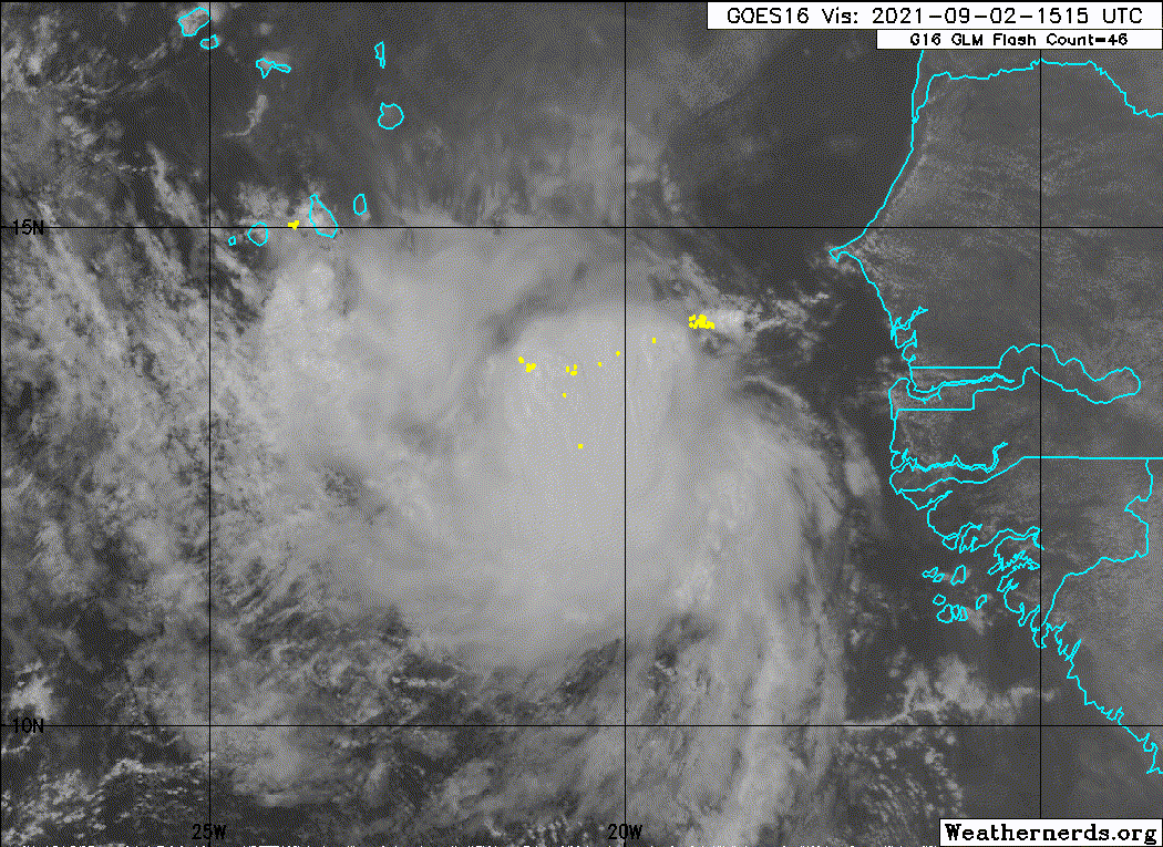
Invest 92L
As of 18:00 UTC Sep 02, 2021:

Location: 13.0°N 20.5°W
Maximum Winds: 25 kt Gusts: N/A
Minimum Central Pressure: 1009 mb
Environmental Pressure: N/A
Radius of Circulation: N/A
Radius of Maximum wind: 60 nm
0 likes   
Personal forecast disclaimer
This post is a personal point of view, not an information. Please refer to official statements for life-threatening decisions.

David '79, Frederic '79, Hugo '89, Iris, Luis & Marilyn '95, Georges '98, Lenny '99, Dean '07, Irma '17, Maria '17, Fiona '22, Philippe '23, Tammy '23
16°13'33.3,"6N -61°36'39.5"W

User avatar
ElectricStorm
Category 5
Category 5
Posts: 4530
Age: 23
Joined: Tue Aug 13, 2019 11:23 pm
Location: Skiatook, OK / Norman, OK

Re: ATL: INVEST 92L - Discussion

#5 Postby ElectricStorm » Thu Sep 02, 2021 1:32 pm

Not expecting much out of this for now due to the outflow from Larry. Maybe it can get something going further west down the road.
0 likes   
I am in no way a professional. Take what I say with a grain of salt as I could be totally wrong. Please refer to the NHC, NWS, or SPC for official information.

Boomer Sooner!

Sciencerocks
Category 5
Category 5
Posts: 7286
Age: 38
Joined: Thu Jul 06, 2017 1:51 am

Re: ATL: INVEST 92L - Discussion

#6 Postby Sciencerocks » Thu Sep 02, 2021 1:46 pm

Image
5 likes   

Sciencerocks
Category 5
Category 5
Posts: 7286
Age: 38
Joined: Thu Jul 06, 2017 1:51 am

Re: ATL: INVEST 92L - Discussion

#7 Postby Sciencerocks » Thu Sep 02, 2021 2:01 pm

Within my opinion this probably has a LLC and is probably pretty close to classifiable. We will see if the convection can sustain itsself of course.
4 likes   

User avatar
Hurricaneman
Category 5
Category 5
Posts: 7281
Age: 43
Joined: Tue Aug 31, 2004 3:24 pm
Location: central florida

Re: ATL: INVEST 92L - Discussion

#8 Postby Hurricaneman » Thu Sep 02, 2021 2:11 pm

This could be a sleeper that gets much farther west as seen in the Canadian but it all depends on the space between this and Larry as more space could allow the ridge to build back in and send it possibly near the US but if not sufficient space could get dragged up around 60w and absorbed. It will be a long few days of watching 92L
0 likes   

User avatar
Hurricaneman
Category 5
Category 5
Posts: 7281
Age: 43
Joined: Tue Aug 31, 2004 3:24 pm
Location: central florida

Re: ATL: INVEST 92L - Discussion

#9 Postby Hurricaneman » Thu Sep 02, 2021 2:17 pm

IcyTundra wrote:I don't think this going to do much early due to the shear from Larry's outflow. The bad thing about that though is that it could possibly get further west if it stays weaker or fails to develop in the MDR.


Actually looking at this it has just enough space to be outside the outflow but could get close enough to get northerly shear from outflow if it gets any closer to Larry
0 likes   

AutoPenalti
Category 5
Category 5
Posts: 3949
Age: 27
Joined: Mon Aug 17, 2015 4:16 pm
Location: Ft. Lauderdale, Florida

Re: ATL: INVEST 92L - Discussion

#10 Postby AutoPenalti » Thu Sep 02, 2021 2:19 pm

You know for a wave that looks to dissipate quickly because of outflow shear, it looks pretty healthy.
7 likes   
The posts in this forum are NOT official forecasts and should not be used as such. They are just the opinion of the poster and may or may not be backed by sound meteorological data. They are NOT endorsed by any professional institution or STORM2K. For official information, please refer to products from the NHC and NWS.


Model Runs Cheat Sheet:
GFS (5:30 AM/PM, 11:30 AM/PM)
HWRF, GFDL, UKMET, NAVGEM (6:30-8:00 AM/PM, 12:30-2:00 AM/PM)
ECMWF (1:45 AM/PM)

TCVN
is a weighted averaged

User avatar
cycloneye
Admin
Admin
Posts: 139065
Age: 67
Joined: Thu Oct 10, 2002 10:54 am
Location: San Juan, Puerto Rico

Re: ATL: INVEST 92L - Discussion

#11 Postby cycloneye » Thu Sep 02, 2021 6:41 pm

Showers and thunderstorms associated with an area of low pressure
located a couple of hundred miles southeast of the southernmost Cabo
Verde Islands continue to show some signs of organization. Some
limited development of this system could occur tonight and on
Friday as the low moves generally westward at 10 to 15 mph. After
that time, conditions are expected to become less conducive for
development. Interests in the Cabo Verde Islands should monitor
the progress of this system.
* Formation chance through 48 hours...low...30 percent.
* Formation chance through 5 days...low...30 percent.
0 likes   
Visit the Caribbean-Central America Weather Thread where you can find at first post web cams,radars
and observations from Caribbean basin members Click Here

User avatar
cycloneye
Admin
Admin
Posts: 139065
Age: 67
Joined: Thu Oct 10, 2002 10:54 am
Location: San Juan, Puerto Rico

Re: ATL: INVEST 92L - Discussion

#12 Postby cycloneye » Fri Sep 03, 2021 6:35 am

An eastern Atlantic tropical wave has its axis along 25W, from 04N
to 19N, moving W around 15 kt. The weak low pressure that had been
associated with this wave has diminished early this morning and
related showers and thunderstorms have also continued to decrease.
In addition, recent satellite derived wind data indicate that the
system does not have a closed circulation. This disturbance is
expected to move westward into an environment less conducive for
development during the next couple of days, and the chances of
formation appear to be decreasing. This system could bring showers
and gusty winds to portions of the southernmost Cabo Verde
Islands during the next several hours. The disturbance has a low
chance of tropical cyclone formation during the next 48 hr.
0 likes   
Visit the Caribbean-Central America Weather Thread where you can find at first post web cams,radars
and observations from Caribbean basin members Click Here

User avatar
cycloneye
Admin
Admin
Posts: 139065
Age: 67
Joined: Thu Oct 10, 2002 10:54 am
Location: San Juan, Puerto Rico

Re: ATL: INVEST 92L - Discussion

#13 Postby cycloneye » Fri Sep 03, 2021 6:59 am

Minimal shower and thunderstorm activity is occurring in
association with an area of disturbed weather located about 150
miles southwest of the southernmost Cabo Verde Islands. This
disturbance is expected to move westward into an environment less
conducive for development during the next couple of days, and the
chances of formation are decreasing. This system could bring
showers and gusty winds to portions of the southernmost Cabo Verde
Islands for a few more hours.
* Formation chance through 48 hours...low...near 0 percent.
* Formation chance through 5 days...low...near 0 percent.
0 likes   
Visit the Caribbean-Central America Weather Thread where you can find at first post web cams,radars
and observations from Caribbean basin members Click Here

otowntiger
Category 5
Category 5
Posts: 1787
Joined: Tue Aug 31, 2004 7:06 pm
Location: Orlando

Re: ATL: INVEST 92L - Discussion

#14 Postby otowntiger » Fri Sep 03, 2021 10:00 am

cycloneye wrote:
Minimal shower and thunderstorm activity is occurring in
association with an area of disturbed weather located about 150
miles southwest of the southernmost Cabo Verde Islands. This
disturbance is expected to move westward into an environment less
conducive for development during the next couple of days, and the
chances of formation are decreasing. This system could bring
showers and gusty winds to portions of the southernmost Cabo Verde
Islands for a few more hours.
* Formation chance through 48 hours...low...near 0 percent.
* Formation chance through 5 days...low...near 0 percent.


soooo... poof. 8-) :wink:
0 likes   


Return to “2021”

Who is online

Users browsing this forum: No registered users and 66 guests