Subjective dovrak is less than useless right now. ADT seems pretty spot-on for intensity
Unfortunately we won't get anything more than a CAT2 until TCR
EPAC: OLAF - Post-Tropical
Moderator: S2k Moderators
-
supercane4867
- Category 5

- Posts: 4966
- Joined: Wed Nov 14, 2012 10:43 am
Re: EPAC: OLAF - Hurricane
1 likes
-
bob rulz
- Category 5
- Posts: 1667
- Age: 34
- Joined: Sat Jan 28, 2006 7:30 pm
- Location: Salt Lake City, Utah
Re: EPAC: OLAF - Hurricane
Definite big burst of intensification right before landfall. Very impressive for a hurricane that was barely expected to make cat 1 and just miss the peninsula to the west.
4 likes
-
Yellow Evan

- Professional-Met

- Posts: 15951
- Age: 25
- Joined: Fri Jul 15, 2011 12:48 pm
- Location: Henderson, Nevada/Honolulu, HI
- Contact:
Re: EPAC: OLAF - Hurricane
----- Current Analysis -----
Date : 10 SEP 2021 Time : 015031 UTC
Lat : 22:57:35 N Lon : 109:26:24 W
CI# /Pressure/ Vmax
5.3 / 957.6mb/ 97.2kt
Final T# Adj T# Raw T#
5.3 5.9 6.0
Estimated radius of max. wind based on IR : 12 km
Center Temp : -5.1C Cloud Region Temp : -67.4C
Scene Type : EYE
Date : 10 SEP 2021 Time : 015031 UTC
Lat : 22:57:35 N Lon : 109:26:24 W
CI# /Pressure/ Vmax
5.3 / 957.6mb/ 97.2kt
Final T# Adj T# Raw T#
5.3 5.9 6.0
Estimated radius of max. wind based on IR : 12 km
Center Temp : -5.1C Cloud Region Temp : -67.4C
Scene Type : EYE
0 likes
-
Kingarabian

- S2K Supporter

- Posts: 15432
- Joined: Sat Aug 08, 2009 3:06 am
- Location: Honolulu, Hawaii
Re: EPAC: OLAF - Hurricane
Pretty much landfall. Looks like land friction really helped it tighten up.
5 likes
RIP Kobe Bryant

Re: EPAC: OLAF - Hurricane
Olaf's unexpected intensification and last-minute convective bursts just before landfall remind me a lot of Grace. I think recon would have found a major if they were in the storm.
0 likes
-
Yellow Evan
- Professional-Met
- Posts: 15951
- Age: 25
- Joined: Fri Jul 15, 2011 12:48 pm
- Location: Henderson, Nevada/Honolulu, HI
- Contact:
Re: EPAC: OLAF - Hurricane
Kingarabian wrote:Pretty much landfall. Looks like land friction really helped it tighten up.
https://i.postimg.cc/0541MtQt/goes17-ir-goes17-meso2.gif
Agreed. Also the third storm this season to deepen while making landfall.
1 likes
-
grapealcoholic
- Category 2

- Posts: 634
- Joined: Tue Aug 10, 2021 3:26 pm


-
Kingarabian
- S2K Supporter
- Posts: 15432
- Joined: Sat Aug 08, 2009 3:06 am
- Location: Honolulu, Hawaii
Re: EPAC: OLAF - Hurricane
Satellite imagery and radar show landfall but the NHC doesn't yet call it:
Hurricane Olaf Advisory Number 10
NWS National Hurricane Center Miami FL EP152021
900 PM MDT Thu Sep 09 2021
...EYE OF OLAF ABOUT TO MAKE LANDFALL AT SAN JOSE DEL CABO MEXICO...
...HURRICANE CONDITIONS SPREADING ACROSS THE SOUTHERN PORTION OF
BAJA CALIFORNIA SUR...
SUMMARY OF 900 PM MDT...0300 UTC...INFORMATION
----------------------------------------------
LOCATION...23.0N 109.6W
ABOUT 20 MI...35 KM ENE OF CABO SAN LUCAS MEXICO
ABOUT 95 MI...150 KM SSE OF LA PAZ MEXICO
MAXIMUM SUSTAINED WINDS...100 MPH...155 KM/H
PRESENT MOVEMENT...NW OR 325 DEGREES AT 12 MPH...19 KM/H
MINIMUM CENTRAL PRESSURE...974 MB...28.77 INCHES
WATCHES AND WARNINGS
--------------------
CHANGES WITH THIS ADVISORY:
None.
SUMMARY OF WATCHES AND WARNINGS IN EFFECT:
A Hurricane Warning is in effect for...
* Baja California Sur Mexico from Los Barriles to Cabo San Lazaro.
A Tropical Storm Warning is in effect for...
* Baja California Sur Mexico north of Cabo San Lazaro to Puerto San
Andresito
* Baja California Sur Mexico north of Los Barriles to Loreto
A Hurricane Warning means that hurricane conditions are expected
somewhere within the hurricane warning area, in this case within
the next 12 to 24 hours. Preparations to protect life and property
should be rushed to completion.
A Tropical Storm Warning means that tropical storm conditions are
expected somewhere within the tropical storm warning area within 36
hours.
Interests elsewhere in Baja California Sur should monitor the
progress of Olaf.
For storm information specific to your area, please monitor
products issued by your national meteorological service.
0 likes
RIP Kobe Bryant
-
Kingarabian
- S2K Supporter
- Posts: 15432
- Joined: Sat Aug 08, 2009 3:06 am
- Location: Honolulu, Hawaii
Re: EPAC: OLAF - Hurricane
WTPZ45 KNHC 100248
TCDEP5
Hurricane Olaf Discussion Number 10
NWS National Hurricane Center Miami FL EP152021
900 PM MDT Thu Sep 09 2021
Imagery from the Mexican radar at Cabo San Lucas, along with
satellite imagery, indicates that the eye of Olaf is about to
make landfall near San Jose del Cabo, and that hurricane conditions
in the northwestern eyewall have already spread onshore. The
eyewall cloud tops have cooled during the past few hours, and the
objective intensity estimate from the CIMSS ADT technique has
increased to 90 kt. Based on this and an increase in the
organization of the eyewall on the Cabo radar imagery, the initial
intensity is increased to 85 kt.
The initial motion is 325/10. Olaf should continue moving
northwestward to north-northwestward for the next 12-24 h, with the
center moving near or over the southern portion of the Baja
California peninsula during this time. After that, a mid-level
ridge extending westward from the southwestern United States should
cause Olaf to turn westward, and this should be followed by a
southwestward motion as the weakening cyclone becomes steered by
low-level northeasterly flow. The forecast guidance has changed
little since the previous advisory, and the new forecast track has
only minor adjustments from the previous forecast.
A gradual weakening is expected during the first 24 h as Olaf
interacts with the Baja California peninsula. When the cyclone
turns westward after 24 h, it should move over colder water and
into a drier air mass. This combination should cause the
convection to decay, with the system becoming a post-tropical low
by 60 h and a remnant low by 72 h. The new intensity forecast has
some minor changes from the previous forecast, and it lies in the
middle of the intensity guidance envelope.
Key Messages:
1. Olaf is forecast to move very near or over the southern portion
of Baja California Sur tonight and Friday. Hurricane conditions
have begun within the southern portion of the hurricane warning
area tonight and will spread northward through Friday.
2. Heavy rains associated with Olaf are expected across portions of
southern Baja California Sur through Friday. This will pose a threat
of significant and life-threatening flash flooding and mudslides.
FORECAST POSITIONS AND MAX WINDS
INIT 10/0300Z 23.0N 109.6W 85 KT 100 MPH
12H 10/1200Z 23.9N 110.7W 75 KT 85 MPH...INLAND
24H 11/0000Z 24.6N 112.3W 65 KT 75 MPH...OVER WATER
36H 11/1200Z 24.8N 113.6W 55 KT 65 MPH
48H 12/0000Z 24.4N 114.8W 45 KT 50 MPH
60H 12/1200Z 23.7N 115.9W 35 KT 40 MPH...POST-TROPICAL
72H 13/0000Z 23.0N 117.2W 30 KT 35 MPH...POST-TROP/REMNT LOW
96H 14/0000Z 21.6N 120.0W 25 KT 30 MPH...POST-TROP/REMNT LOW
120H 15/0000Z 21.0N 122.0W 20 KT 25 MPH...POST-TROP/REMNT LOW
$$
Forecaster Beven
0 likes
RIP Kobe Bryant
-
Yellow Evan
- Professional-Met
- Posts: 15951
- Age: 25
- Joined: Fri Jul 15, 2011 12:48 pm
- Location: Henderson, Nevada/Honolulu, HI
- Contact:
Re: EPAC: OLAF - Hurricane
Good decision by him earlier to go east to San Jose del Cabo
https://twitter.com/icyclone/status/1436159320345939970
https://twitter.com/icyclone/status/1436159320345939970
Last edited by NDG on Thu Sep 09, 2021 9:52 pm, edited 1 time in total.
2 likes
-
grapealcoholic
- Category 2
- Posts: 634
- Joined: Tue Aug 10, 2021 3:26 pm
Re: EPAC: OLAF - Hurricane
Yellow Evan wrote:https://twitter.com/icyclone/status/1436159320345939970?s=21
Interesting. Needed more time
4 likes
-
Kingarabian
- S2K Supporter
- Posts: 15432
- Joined: Sat Aug 08, 2009 3:06 am
- Location: Honolulu, Hawaii
Re: EPAC: OLAF - Hurricane
Very possible that the pressure and winds didn't catch up to the rapid deepening.
0 likes
RIP Kobe Bryant
-
grapealcoholic
- Category 2
- Posts: 634
- Joined: Tue Aug 10, 2021 3:26 pm
Re: EPAC: OLAF - Hurricane
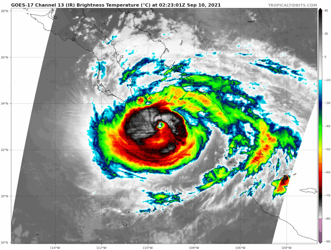
Current Intensity Analysis
UW - CIMSS
ADVANCED DVORAK TECHNIQUE
ADT-Version 9.0
Tropical Cyclone Intensity Algorithm
----- Current Analysis -----
Date : 10 SEP 2021 Time : 022031 UTC
Lat : 23:02:24 N Lon : 109:25:11 W
CI# /Pressure/ Vmax
5.5 / 953.7mb/102.0kt
Final T# Adj T# Raw T#
5.5 5.9 6.1
Estimated radius of max. wind based on IR : 14 km
Center Temp : -6.6C Cloud Region Temp : -68.6C
Scene Type : EYE
1 likes
-
Yellow Evan
- Professional-Met
- Posts: 15951
- Age: 25
- Joined: Fri Jul 15, 2011 12:48 pm
- Location: Henderson, Nevada/Honolulu, HI
- Contact:
Re: EPAC: OLAF - Hurricane
Kingarabian wrote:Very possible that the pressure and winds didn't catch up to the rapid deepening.
This is likely what happened. Olaf probably reaches Cat 3 with another six hours with no problem assuming a deepening rate of 2.5 mbar/hour.
1 likes
-
grapealcoholic
- Category 2
- Posts: 634
- Joined: Tue Aug 10, 2021 3:26 pm
-
Yellow Evan
- Professional-Met
- Posts: 15951
- Age: 25
- Joined: Fri Jul 15, 2011 12:48 pm
- Location: Henderson, Nevada/Honolulu, HI
- Contact:
-
Yellow Evan
- Professional-Met
- Posts: 15951
- Age: 25
- Joined: Fri Jul 15, 2011 12:48 pm
- Location: Henderson, Nevada/Honolulu, HI
- Contact:
-
Yellow Evan
- Professional-Met
- Posts: 15951
- Age: 25
- Joined: Fri Jul 15, 2011 12:48 pm
- Location: Henderson, Nevada/Honolulu, HI
- Contact:
Who is online
Users browsing this forum: No registered users and 24 guests