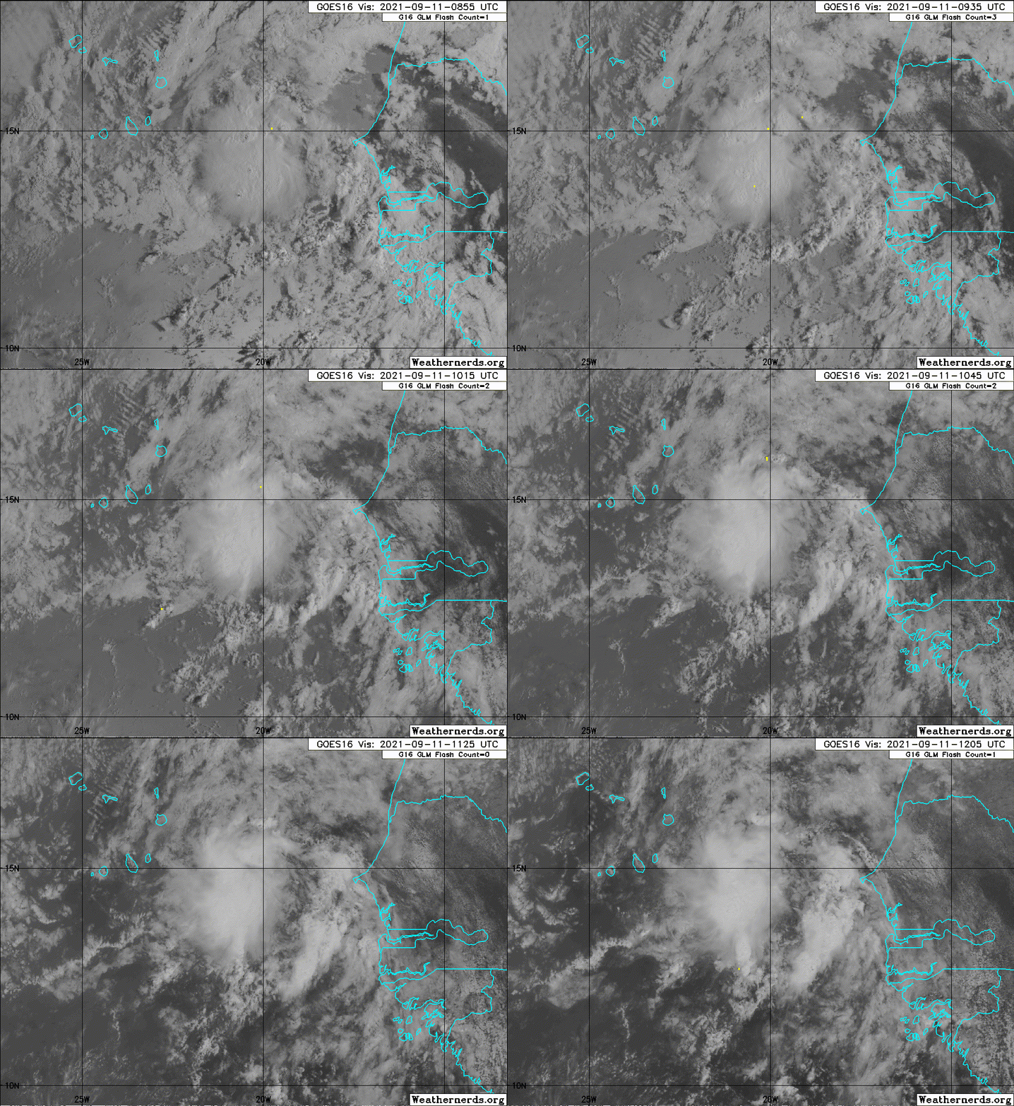
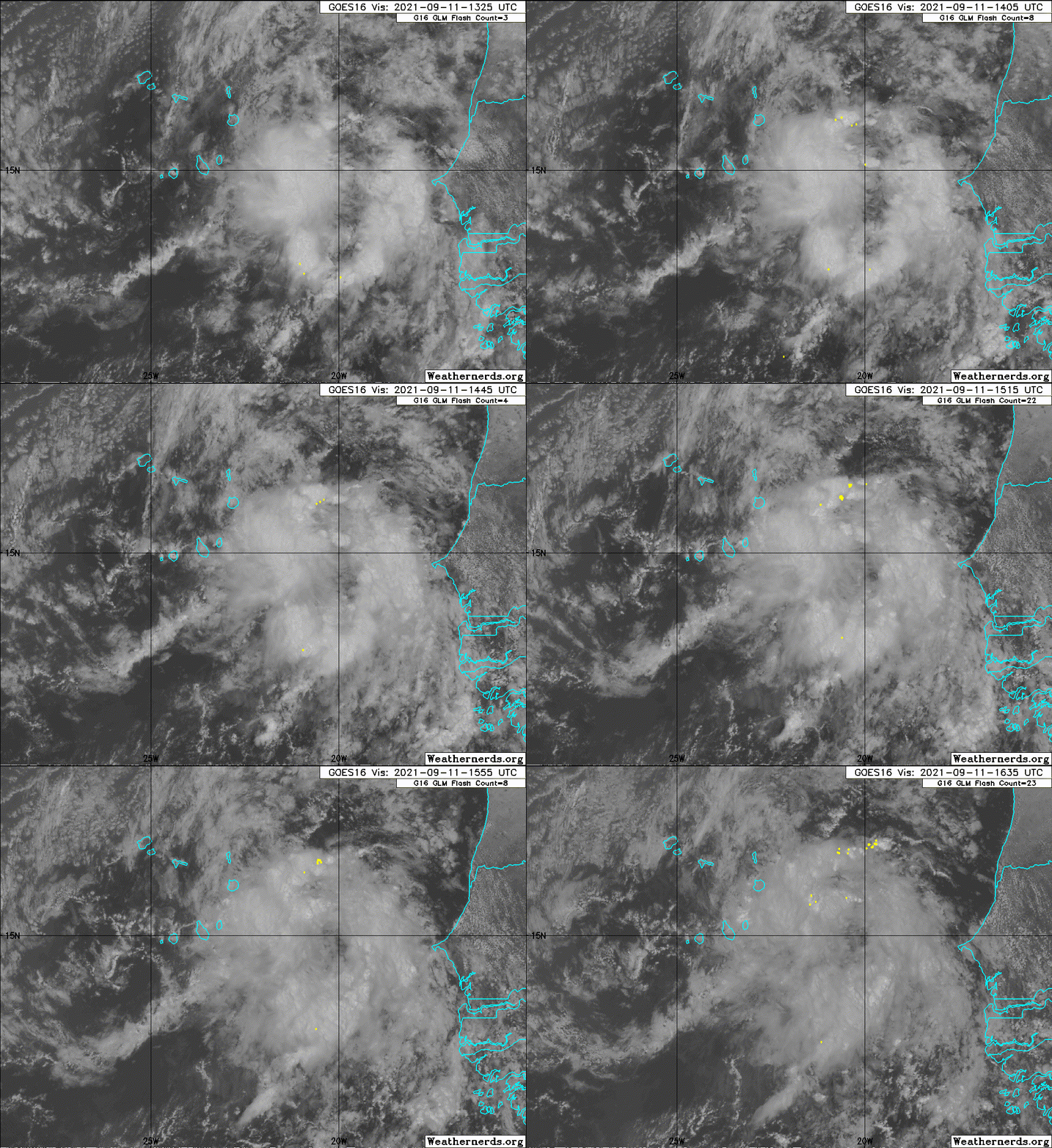
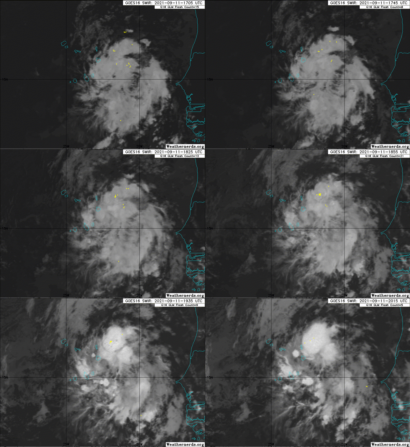
ATL: INVEST 93L - Discussion

Moderator: S2k Moderators

Message
Author
AlphaToOmega
Category 5
Category 5
Posts: 1448
Joined: Sat Jun 26, 2021 10:51 am
Location: Somewhere in Massachusetts

Re: ATL: INVEST 93L - Discussion

#21 Postby AlphaToOmega » Sat Sep 11, 2021 5:00 am

Kohlecane wrote:
AlphaToOmega wrote:
CrazyC83 wrote:It seems the models are not too impressed with this though. Poor conditions ahead?

Ensembles are still impressed

https://i.imgur.com/9TkJh0u.png
I know this is the discussion, but it seems that yes ensembles do support but it looks like AOI below 93L is getting the majority of support, then again I could be mistaken.

Ensembles also support Invest 93L itself.
0 likes   

User avatar
Kohlecane
Category 2
Category 2
Posts: 565
Age: 32
Joined: Sun Jul 31, 2011 11:03 pm
Location: Beaufort, SC

Re: ATL: INVEST 93L - Discussion

#22 Postby Kohlecane » Sat Sep 11, 2021 5:07 am

AlphaToOmega wrote:
CrazyC83 wrote:It seems the models are not too impressed with this though. Poor conditions ahead?

Ensembles are still impressed


I know this is the 93L discussion, but it seems that yes! ensembles do like support, but it looks like AOI below 93L future 95L just south (unless that SE coast AOI pops up sooner) is getting the majority of support, then again I could be mistaken.
Image
EDIT: sorry duplicate post tried to delete old but has been replied/quoted already, just putting up image*
Last edited by Kohlecane on Sat Sep 11, 2021 5:12 am, edited 1 time in total.
1 likes   
Once I see the REDS and GREENS Converge on a Base Velocity. ... I'm There!!

This is NOT an Official Forecast....Just my Opinion. For official information, please refer to the NHC and NWS products.
HIGHLIGHTS : '13 El Reno Tornado : 2013 Storm Chaser Tour, Joaquin; SC flood event, Matthew '16, Lowcountry Snow storm Jan '18

AlphaToOmega
Category 5
Category 5
Posts: 1448
Joined: Sat Jun 26, 2021 10:51 am
Location: Somewhere in Massachusetts

Re: ATL: INVEST 93L - Discussion

#23 Postby AlphaToOmega » Sat Sep 11, 2021 5:11 am

The models still all show closed lows. This is likely to develop into a weak 40-knot tropical storm.
0 likes   

User avatar
aspen
Category 5
Category 5
Posts: 8054
Joined: Sat Oct 12, 2019 7:10 pm
Location: Connecticut, USA

Re: ATL: INVEST 93L - Discussion

#24 Postby aspen » Sat Sep 11, 2021 6:07 am

Seems like all models agree on a westward track instead of an early recurve. Assuming 93L can survive the tough road ahead (SHIPS has 20-25 kt of shear in the 4-6 day range), we might have to worry about this developing closer to the Caribbean and CONUS.
1 likes   
Irene '11 Sandy '12 Hermine '16 5/15/2018 Derecho Fay '20 Isaias '20 Elsa '21 Henri '21 Ida '21

I am only a meteorology enthusiast who knows a decent amount about tropical cyclones. Look to the professional mets, the NHC, or your local weather office for the best information.

User avatar
cycloneye
Admin
Admin
Posts: 139010
Age: 67
Joined: Thu Oct 10, 2002 10:54 am
Location: San Juan, Puerto Rico

Re: ATL: INVEST 93L - Discussion

#25 Postby cycloneye » Sat Sep 11, 2021 6:43 am

A tropical wave continues to produce a concentrated area of showers
and thunderstorms just southeast of the Cabo Verde Islands.
Environmental conditions appear generally conducive for gradual
development, and a tropical depression is likely to form late this
weekend or early next week while the system moves westward over the
far eastern Atlantic. Regardless of development, this system is
likely to bring gusty winds and locally heavy rain across the Cabo
Verde Islands later today and tonight.
* Formation chance through 48 hours...medium...50 percent.
* Formation chance through 5 days...high...70 percent.
0 likes   
Visit the Caribbean-Central America Weather Thread where you can find at first post web cams,radars
and observations from Caribbean basin members Click Here

Sciencerocks
Category 5
Category 5
Posts: 7282
Age: 38
Joined: Thu Jul 06, 2017 1:51 am

Re: ATL: INVEST 93L - Discussion

#26 Postby Sciencerocks » Sat Sep 11, 2021 7:28 am

Image
2 likes   

User avatar
ouragans
Category 1
Category 1
Posts: 464
Age: 52
Joined: Sun Jun 12, 2011 12:09 pm
Location: Abymes, Guadeloupe F.W.I
Contact:

Re: ATL: INVEST 93L - Discussion

#27 Postby ouragans » Sat Sep 11, 2021 8:02 am

Invest 93L
As of 12:00 UTC Sep 11, 2021:

Location: 14.2°N 21.1°W
Maximum Winds: 25 kt Gusts: N/A
Minimum Central Pressure: 1010 mb
Environmental Pressure: N/A
Radius of Circulation: N/A
Radius of Maximum wind: 60 nm
0 likes   
Personal forecast disclaimer
This post is just a personal point of view, not an information. Please refer to official statements for life-threatening decisions.

David '79, Frederic '79, Hugo '89, Iris '95, Luis '95, Marilyn '95, Georges '98, Lenny '99, Dean '07, Irma '17, Maria '17, Fiona '22
16°13'33.3,"6N -61°36'39.5"W

User avatar
CyclonicFury
Category 5
Category 5
Posts: 1970
Age: 25
Joined: Sun Jul 02, 2017 12:32 pm
Location: NC
Contact:

Re: ATL: INVEST 93L - Discussion

#28 Postby CyclonicFury » Sat Sep 11, 2021 10:32 am

AlphaToOmega wrote:The models still all show closed lows. This is likely to develop into a weak 40-knot tropical storm.

A closed circulation on the model does not always indicate a TC. Organized deep convection is another requirement for classification. With the expected marginal SSTs and dry mid level environment, this one may struggle to produce consistent deep convection.
3 likes   
NCSU B.S. in Meteorology Class of 2021. Tropical weather blogger at http://www.cyclonicfury.com. My forecasts and thoughts are NOT official, for official forecasts please consult the National Hurricane Center.

AlphaToOmega
Category 5
Category 5
Posts: 1448
Joined: Sat Jun 26, 2021 10:51 am
Location: Somewhere in Massachusetts

Re: ATL: INVEST 93L - Discussion

#29 Postby AlphaToOmega » Sat Sep 11, 2021 10:37 am

I would surprise me if it does not become at least a tropical storm. The NHC and ensembles are enthused by this system. I have seen many systems, namely Kate, Julian, and Mindy, become tropical cyclones with little operational global model support.
1 likes   

LarryWx
Category 5
Category 5
Posts: 5694
Joined: Sun Sep 07, 2003 2:04 pm
Location: GA

Re: ATL: INVEST 93L - Discussion

#30 Postby LarryWx » Sat Sep 11, 2021 10:47 am

AlphaToOmega wrote:I would surprise me if it does not become at least a tropical storm. The NHC and ensembles are enthused by this system. I have seen many systems, namely Kate, Julian, and Mindy, become tropical cyclones with little operational global model support.


Most of the non-GFS models have not done well with this so far. The Euro and UKMET have been downright awful. Keeping this in mind, there’s no telling what it may end up doing. They now MAY be downplaying this. SSTs are warm enough to support a TC. And depending on how it does or doesn’t progress developmentwise, dry air may not be enough to prevent a formidable TC within a few days. Shear doesn’t appear to be prohibitively too high even if it isn’t light right now. There seems to be a decent LLC. We’re at the peak in La Niña. I wouldn’t downplay what this MAY do at this point, especially as it reaches warmer SSTs. And this may have a big influence on the next AEW that the Euro is going crazy over.
1 likes   
Personal Forecast Disclaimer:
The posts in this forum are NOT official forecasts and should not be used as such. They are just the opinion of the poster and may or may not be backed by sound meteorological data. They are NOT endorsed by any professional institution or storm2k.org. For official information, please refer to the NHC and NWS products.

TallyTracker
Category 2
Category 2
Posts: 584
Joined: Thu Oct 11, 2018 2:46 pm

Re: ATL: INVEST 93L - Discussion

#31 Postby TallyTracker » Sat Sep 11, 2021 10:58 am

SSTs are more than adequate for the next couple of days and shouldn’t impede development. Dry air is gonna be the bigger issue. If it moves north of the Cabo Verde’s, then SSTs become an issue. The OHC is low in this area, but that only matters for stronger storms.
1 likes   
Fran '96, Georges '98, Gordon '00, Gabrielle '01, Charley '04, Frances '04, Jeanne '04, Barry '07, Fay '08, Debby '12, Matthew '16, Emily '17, Irma '17, Michael ‘18, Elsa ‘21, Fred ‘21, Mindy ‘21, Nicole ‘22, Idalia ‘23

User avatar
Teban54
Category 5
Category 5
Posts: 1946
Joined: Sat May 19, 2018 1:19 pm

Re: ATL: INVEST 93L - Discussion

#32 Postby Teban54 » Sat Sep 11, 2021 11:06 am

Am I even looking at the same storm as you guys? 93L is able to produce persistent convection since last night, despite not very cold cloud tops. Should be enough for at least a weak TD/TS if this continues IMO.
4 likes   

Sciencerocks
Category 5
Category 5
Posts: 7282
Age: 38
Joined: Thu Jul 06, 2017 1:51 am

Re: ATL: INVEST 93L - Discussion

#33 Postby Sciencerocks » Sat Sep 11, 2021 12:02 pm

Image
1 likes   

User avatar
cycloneye
Admin
Admin
Posts: 139010
Age: 67
Joined: Thu Oct 10, 2002 10:54 am
Location: San Juan, Puerto Rico

Re: ATL: INVEST 93L - Discussion

#34 Postby cycloneye » Sat Sep 11, 2021 12:44 pm

Showers and thunderstorms have not become any better organized in
association with a tropical wave located just southeast of the Cabo
Verde Islands. Environmental conditions appear generally conducive
for gradual development, and a tropical depression is likely to form
late this weekend or early next week while the system moves westward
over the far eastern Atlantic. Regardless of development, this
disturbance is likely to bring gusty winds and locally heavy rain
across the Cabo Verde Islands later today and tonight.
* Formation chance through 48 hours...medium...50 percent.
* Formation chance through 5 days...high...70 percent.
0 likes   
Visit the Caribbean-Central America Weather Thread where you can find at first post web cams,radars
and observations from Caribbean basin members Click Here

User avatar
ElectricStorm
Category 5
Category 5
Posts: 4521
Age: 23
Joined: Tue Aug 13, 2019 11:23 pm
Location: Skiatook, OK / Norman, OK

Re: ATL: INVEST 93L - Discussion

#35 Postby ElectricStorm » Sat Sep 11, 2021 12:48 pm

As of right now I think we might see a TD/weak TS out of this but not much more. If it says weak and makes it further west, we may have to watch out for it down the line.
0 likes   
I am in no way a professional. Take what I say with a grain of salt as I could be totally wrong. Please refer to the NHC, NWS, or SPC for official information.

Boomer Sooner!

User avatar
aspen
Category 5
Category 5
Posts: 8054
Joined: Sat Oct 12, 2019 7:10 pm
Location: Connecticut, USA

Re: ATL: INVEST 93L - Discussion

#36 Postby aspen » Sat Sep 11, 2021 1:44 pm

It doesn’t look bad now, but nothing really develops this anymore. Could end up as a sleeper wave or a weak system that struggles until it gets further west…or it’ll be a Vicky/Wilfred repeat.
0 likes   
Irene '11 Sandy '12 Hermine '16 5/15/2018 Derecho Fay '20 Isaias '20 Elsa '21 Henri '21 Ida '21

I am only a meteorology enthusiast who knows a decent amount about tropical cyclones. Look to the professional mets, the NHC, or your local weather office for the best information.

Sciencerocks
Category 5
Category 5
Posts: 7282
Age: 38
Joined: Thu Jul 06, 2017 1:51 am

Re: ATL: INVEST 93L - Discussion

#37 Postby Sciencerocks » Sat Sep 11, 2021 3:40 pm

Image
0 likes   

hipshot
Category 1
Category 1
Posts: 468
Joined: Tue Jul 06, 2010 9:18 pm
Location: Dallas, Texas

Re: ATL: INVEST 93L - Discussion

#38 Postby hipshot » Sat Sep 11, 2021 4:59 pm

LarryWx wrote:
AlphaToOmega wrote:I would surprise me if it does not become at least a tropical storm. The NHC and ensembles are enthused by this system. I have seen many systems, namely Kate, Julian, and Mindy, become tropical cyclones with little operational global model support.


Most of the non-GFS models have not done well with this so far. The Euro and UKMET have been downright awful. Keeping this in mind, there’s no telling what it may end up doing. They now MAY be downplaying this. SSTs are warm enough to support a TC. And depending on how it does or doesn’t progress developmentwise, dry air may not be enough to prevent a formidable TC within a few days. Shear doesn’t appear to be prohibitively too high even if it isn’t light right now. There seems to be a decent LLC. We’re at the peak in La Niña. I wouldn’t downplay what this MAY do at this point, especially as it reaches warmer SSTs. And this may have a big influence on the next AEW that the Euro is going crazy over.

What is an "AEW"? African ?? Wave?
0 likes   

AlphaToOmega
Category 5
Category 5
Posts: 1448
Joined: Sat Jun 26, 2021 10:51 am
Location: Somewhere in Massachusetts

Re: ATL: INVEST 93L - Discussion

#39 Postby AlphaToOmega » Sat Sep 11, 2021 5:02 pm

hipshot wrote:
LarryWx wrote:
AlphaToOmega wrote:I would surprise me if it does not become at least a tropical storm. The NHC and ensembles are enthused by this system. I have seen many systems, namely Kate, Julian, and Mindy, become tropical cyclones with little operational global model support.


Most of the non-GFS models have not done well with this so far. The Euro and UKMET have been downright awful. Keeping this in mind, there’s no telling what it may end up doing. They now MAY be downplaying this. SSTs are warm enough to support a TC. And depending on how it does or doesn’t progress developmentwise, dry air may not be enough to prevent a formidable TC within a few days. Shear doesn’t appear to be prohibitively too high even if it isn’t light right now. There seems to be a decent LLC. We’re at the peak in La Niña. I wouldn’t downplay what this MAY do at this point, especially as it reaches warmer SSTs. And this may have a big influence on the next AEW that the Euro is going crazy over.

What is an "AEW"? African ?? Wave?

AEW = African Easterly Wave = tropical wave coming off the coast of West Africa
1 likes   

LarryWx
Category 5
Category 5
Posts: 5694
Joined: Sun Sep 07, 2003 2:04 pm
Location: GA

Re: ATL: INVEST 93L - Discussion

#40 Postby LarryWx » Sat Sep 11, 2021 5:02 pm

hipshot wrote:
LarryWx wrote:
AlphaToOmega wrote:I would surprise me if it does not become at least a tropical storm. The NHC and ensembles are enthused by this system. I have seen many systems, namely Kate, Julian, and Mindy, become tropical cyclones with little operational global model support.


Most of the non-GFS models have not done well with this so far. The Euro and UKMET have been downright awful. Keeping this in mind, there’s no telling what it may end up doing. They now MAY be downplaying this. SSTs are warm enough to support a TC. And depending on how it does or doesn’t progress developmentwise, dry air may not be enough to prevent a formidable TC within a few days. Shear doesn’t appear to be prohibitively too high even if it isn’t light right now. There seems to be a decent LLC. We’re at the peak in La Niña. I wouldn’t downplay what this MAY do at this point, especially as it reaches warmer SSTs. And this may have a big influence on the next AEW that the Euro is going crazy over.

What is an "AEW"? African ?? Wave?


Yes, African Easterly Wave.
0 likes   
Personal Forecast Disclaimer:
The posts in this forum are NOT official forecasts and should not be used as such. They are just the opinion of the poster and may or may not be backed by sound meteorological data. They are NOT endorsed by any professional institution or storm2k.org. For official information, please refer to the NHC and NWS products.


Return to “2021”

Who is online

Users browsing this forum: No registered users and 11 guests