ATL: NICHOLAS - Post-Tropical - Discussion

Moderator: S2k Moderators

Message
Author
User avatar
Steve
S2K Supporter
S2K Supporter
Posts: 8603
Joined: Sat Apr 05, 2003 11:41 pm
Location: Not a state-caster

Re: ATL: NICHOLAS - Tropical Depression - Discussion

#1181 Postby Steve » Wed Sep 15, 2021 9:49 am

underthwx wrote:Good morning all ...I'm taking advantage of a few minutes of signal on my phone to wish all of you affected by both Ida and Nicholas well....no power here....but it's all good....could have been much worse....yall be good....stay safe..


Glad to hear from you under. We ended up staying up to about 2am on the porch watching a strong band come in. Still seeing some light bands today rolling in and across the area but not that much heavy rain.
1 likes   

User avatar
runnergal70
Tropical Wave
Tropical Wave
Posts: 6
Age: 54
Joined: Mon Jun 06, 2016 10:04 am
Contact:

Re: ATL: NICHOLAS - Tropical Depression - Discussion

#1182 Postby runnergal70 » Wed Sep 15, 2021 9:53 am

Raining non-stop over here along Mobile Bay in South Alabama. I have been having deja vu from last year Sally that hit this time last year and didn't sleep most of the night. I know Nicholas is just a rain maker for us but the thought of what happen last year here in my little town kind of freaks me out. So far we are only under a Flash Flood Watch and Tornado Watch according to my phone. Well off to work-I'm a delivery driver so I get the full fun of (Not) of driving in this rain. Thanks for all you do here and keeping us updated. I will definitely be tuning in and hoping this thing fizzles out completely.
4 likes   

User avatar
jasons2k
Storm2k Executive
Storm2k Executive
Posts: 8069
Age: 50
Joined: Wed Jul 06, 2005 12:32 pm
Location: The Woodlands, TX

Re: ATL: NICHOLAS - Tropical Depression - Discussion

#1183 Postby jasons2k » Wed Sep 15, 2021 9:57 am

The remnants of Nicholas look cutoff to me.
0 likes   

underthwx
Category 5
Category 5
Posts: 1928
Joined: Sat Jul 30, 2011 2:14 pm
Location: Brazoria County Texas

Re: ATL: NICHOLAS - Tropical Depression - Discussion

#1184 Postby underthwx » Wed Sep 15, 2021 10:02 am

Steve wrote:
underthwx wrote:Good morning all ...I'm taking advantage of a few minutes of signal on my phone to wish all of you affected by both Ida and Nicholas well....no power here....but it's all good....could have been much worse....yall be good....stay safe..


Glad to hear from you under. We ended up staying up to about 2am on the porch watching a strong band come in. Still seeing some light bands today rolling in and across the area but not that much heavy rain.


Appreciate it Steve....yall stay safe...and dry my friend....
1 likes   

Sciencerocks
Category 5
Category 5
Posts: 7266
Age: 38
Joined: Thu Jul 06, 2017 1:51 am

Re: ATL: NICHOLAS - Tropical Depression - Discussion

#1185 Postby Sciencerocks » Wed Sep 15, 2021 11:13 am

Image
1 likes   

User avatar
ScottNAtlanta
Category 5
Category 5
Posts: 1990
Joined: Sat May 25, 2013 3:11 pm
Location: Atlanta, GA

Re: ATL: NICHOLAS - Tropical Depression - Discussion

#1186 Postby ScottNAtlanta » Wed Sep 15, 2021 11:34 am

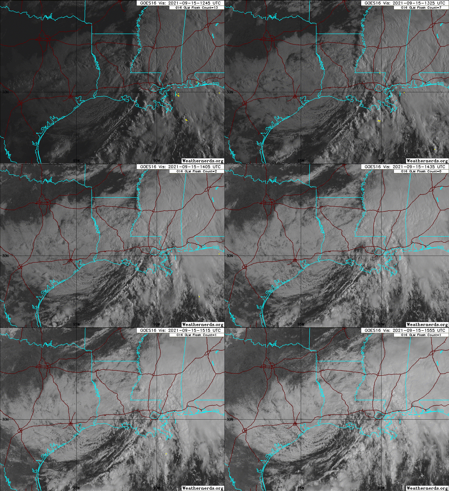
What are those dark spot flying across the animation? Whatever they are, they are going pretty darn fast. It is even more evident with the higher sun angle. If you are flying LAX MIA you are going to have a substantially shorter flight that normal.

Image
3 likes   
The posts in this forum are NOT official forecast and should not be used as such. They are just the opinion of the poster and may or may not be backed by sound meteorological data. They are NOT endorsed by any professional institution or storm2k.org. For official information, please refer to the NHC and NWS products.

User avatar
MississippiWx
S2K Supporter
S2K Supporter
Posts: 1535
Joined: Sat Aug 14, 2010 1:44 pm
Location: Hattiesburg, Mississippi

Re: ATL: NICHOLAS - Tropical Depression - Discussion

#1187 Postby MississippiWx » Wed Sep 15, 2021 12:14 pm

ScottNAtlanta wrote:What are those dark spot flying across the animation? Whatever they are, they are going pretty darn fast. It is even more evident with the higher sun angle. If you are flying LAX MIA you are going to have a substantially shorter flight that normal.

https://i.imgur.com/Crogrgp.gif


Those are high cirrus clouds casting shadows on top of the lower stratus clouds below. They show you why Nicholas no longer has thunderstorms near its center. Very high westerly shear. :wink:
8 likes   
This post is not an official forecast and should not be used as such. It is just the opinion of MississippiWx and may or may not be backed by sound meteorological data. It is not endorsed by any professional institution including storm2k.org. For Official Information please refer to the NHC and NWS products.

LARanger
Tropical Depression
Tropical Depression
Posts: 82
Joined: Wed Oct 07, 2020 12:45 pm

Re: ATL: NICHOLAS - Tropical Storm - Discussion

#1188 Postby LARanger » Wed Sep 15, 2021 2:10 pm

LARanger wrote:At the risk of offending any hydrologists nearby, I've learned just from watching the Amite and Tangi like a damn hawk that the river forecasts are a bit dodgy in relation to unique weather events like 2016 or hurricanes. Don't get me wrong . . . sometimes they're spot on, despite being updated with far less frequency than, say, the NHC forecasts. Other times, even when something's been known to be coming for awhile, they lag or drastically change. In the case of this event, my guess would be that the Little Natalbany won't go much higher than today's forecast, if at all, but that they still got the timing wrong.


Well, as of 30 minutes ago, the Little Natalbany, which was forecast as of the writing above to crest at 14.5, 1.5 below flood stage, is actually at 15.1 and minor flooding at 16.5 is now forecast for 1am crest tonight. So, yes, that's the lag and dodginess I spoke of, but here we also see that my guesses are iffy at best.

Good luck, SG!

As for local observations here, I was surprised to find pretty decent ditch and road flooding at 4am, but it was receding then and, with the rain basically over, the water's dropped back to near normal. I'd guesstimate that this was nearly a match for Ida insofar as water accumulation, but I don't have any data on recorded rainfall amounts for either in this parish.
3 likes   
Baton Rouge area cyclone dilettante, PSWAGGER* tropical weather & hydrology model developer
(* Pseudo-Scientific Wild-A** Guesses Generally Expressed Ridiculously)
The GFDL would've had all this figured out by now.

User avatar
Steve
S2K Supporter
S2K Supporter
Posts: 8603
Joined: Sat Apr 05, 2003 11:41 pm
Location: Not a state-caster

Re: ATL: NICHOLAS - Tropical Depression - Discussion

#1189 Postby Steve » Wed Sep 15, 2021 5:46 pm

Yeah. Earlier in the day you could see what almost looked like a jet blowing fast above the top of Nicholas. You could also see the rain moving off to the east far removed from the remnant center as that energy decoupled. Remnant center looks to be almost back in the Gulf, but it doesn’t look like it can get any mid or upper support and thus will likely spin itself out. Super cool system to track and deal with over the last few days for us here in metro New Orleans.
2 likes   

User avatar
jasons2k
Storm2k Executive
Storm2k Executive
Posts: 8069
Age: 50
Joined: Wed Jul 06, 2005 12:32 pm
Location: The Woodlands, TX

Re: ATL: NICHOLAS - Tropical Depression - Discussion

#1190 Postby jasons2k » Wed Sep 15, 2021 10:09 pm

Steve wrote:Yeah. Earlier in the day you could see what almost looked like a jet blowing fast above the top of Nicholas. You could also see the rain moving off to the east far removed from the remnant center as that energy decoupled. Remnant center looks to be almost back in the Gulf, but it doesn’t look like it can get any mid or upper support and thus will likely spin itself out. Super cool system to track and deal with over the last few days for us here in metro New Orleans.

Can you imagine the amount of rainfall without the shear ripping this thing apart? And this is the peak of the season. It could have been a lot worse from Texas across to Louisiana & MS/AL.
5 likes   

LARanger
Tropical Depression
Tropical Depression
Posts: 82
Joined: Wed Oct 07, 2020 12:45 pm

Re: ATL: NICHOLAS - Tropical Storm - Discussion

#1191 Postby LARanger » Thu Sep 16, 2021 1:12 am

LARanger wrote:Well, as of 30 minutes ago, the Little Natalbany, which was forecast as of the writing above to crest at 14.5, 1.5 below flood stage, is actually at 15.1 and minor flooding at 16.5 is now forecast for 1am crest tonight. So, yes, that's the lag and dodginess I spoke of, but here we also see that my guesses are iffy at best.

Good luck, SG!


Turns out my guesses aren't too bad after all . . . that river never even made it to 15.2, and as of a few minutes ago only a long decline is forecast. That's close enough to my "not much higher, if at all" for me to mark it as a W.
2 likes   
Baton Rouge area cyclone dilettante, PSWAGGER* tropical weather & hydrology model developer
(* Pseudo-Scientific Wild-A** Guesses Generally Expressed Ridiculously)
The GFDL would've had all this figured out by now.

User avatar
Steve
S2K Supporter
S2K Supporter
Posts: 8603
Joined: Sat Apr 05, 2003 11:41 pm
Location: Not a state-caster

Re: ATL: NICHOLAS - Post-Tropical - Discussion

#1192 Postby Steve » Fri Sep 17, 2021 10:02 am

Remnant low has set up some bands which are causing flash flooding over on the MS Coast this morning. There is a boundary backing west which is getting hit by shear but producing some lines of storms that will train today. That appears to be part of a tropical surge from the SE. I figured this would mostly be dissipated by this morning, but that's not the case.

https://www.tropicaltidbits.com/sat/sat ... t=vis-swir

https://radar.weather.gov/?settings=v1_ ... OjAuNn19#/
0 likes   

User avatar
Nimbus
Category 5
Category 5
Posts: 4928
Joined: Mon Jul 19, 2004 10:54 am

Re: ATL: NICHOLAS - Post-Tropical - Discussion

#1193 Postby Nimbus » Fri Sep 17, 2021 10:56 am

Steve wrote:Remnant low has set up some bands which are causing flash flooding over on the MS Coast this morning. There is a boundary backing west which is getting hit by shear but producing some lines of storms that will train today. That appears to be part of a tropical surge from the SE. I figured this would mostly be dissipated by this morning, but that's not the case.

https://www.tropicaltidbits.com/sat/sat ... t=vis-swir

https://radar.weather.gov/?settings=v1_ ... OjAuNn19#/


Definitely enhancing the afternoon thunderstorm activity from NOLA all the way up to Mobile.
I think the peak rain accumulation was near 14 inches in Texas in some small area that got trapped under a squall line of thunderstorms.

A lot of people didn't get their roofs covered with a tarp in time.
1 likes   

User avatar
SoupBone
Category 5
Category 5
Posts: 3073
Joined: Tue Sep 20, 2005 5:24 pm

Re: ATL: NICHOLAS - Post-Tropical - Discussion

#1194 Postby SoupBone » Fri Sep 17, 2021 7:20 pm

Are you guys seeing the rotation on Radarscope? This thing won't die.
2 likes   
Personal Forecast Disclaimer:
The posts in this forum are NOT official forecast and should not be used as such. They are just the opinion of the poster and may or may not be backed by sound meteorological data. They are NOT endorsed by any professional institution or storm2k.org. For official information, please refer to the NHC and NWS products.

sikkar
Category 1
Category 1
Posts: 323
Joined: Sun Aug 26, 2012 1:44 am
Location: Florida

Re: ATL: NICHOLAS - Post-Tropical - Discussion

#1195 Postby sikkar » Fri Sep 17, 2021 9:02 pm

Naked swirl was clearly visible most of the day, also still generating convection.
2 likes   
Personal Forecast Disclaimer:
The posts in this forum are NOT official forecast and should not be used as such. They are just the opinion of the poster and may or may not be backed by sound meteorological data. For official information, please refer to the NHC and NWS products.

User avatar
Steve
S2K Supporter
S2K Supporter
Posts: 8603
Joined: Sat Apr 05, 2003 11:41 pm
Location: Not a state-caster

Re: ATL: NICHOLAS - Post-Tropical - Discussion

#1196 Postby Steve » Sat Sep 18, 2021 12:29 pm

sikkar wrote:Naked swirl was clearly visible most of the day, also still generating convection.


We are still in the warm sector and still getting lines coming in off the gulf. Thunderstorms in Metairie at the moment. Definitely qualifies for the thing that wouldn’t leave for any old SNL fans.
1 likes   

User avatar
InfernoFlameCat
Category 5
Category 5
Posts: 1966
Age: 20
Joined: Mon Dec 14, 2020 10:52 am
Location: Buford, GA

Re: ATL: NICHOLAS - Post-Tropical - Discussion

#1197 Postby InfernoFlameCat » Sun Sep 19, 2021 1:24 pm

The storm is still around. Wow. That is one long lasting remnant low.
1 likes   
I am by no means a professional. DO NOT look at my forecasts for official information or make decisions based on what I post.

Goal: to become a registered expert over tropical and subtropical cyclones.

User avatar
Steve
S2K Supporter
S2K Supporter
Posts: 8603
Joined: Sat Apr 05, 2003 11:41 pm
Location: Not a state-caster

Re: ATL: NICHOLAS - Post-Tropical - Discussion

#1198 Postby Steve » Sun Sep 19, 2021 1:36 pm

InfernoFlameCat wrote:The storm is still around. Wow. That is one long lasting remnant low.


Yeah. We have a line of t-storms moving in from the southwest. It’s thundering now. Glad this had limited precipitation overall or you’d better have that ark ready. It was mostly MJO Phase 3 too. So I’m counting my luck.
2 likes   


Return to “2021”

Who is online

Users browsing this forum: No registered users and 11 guests