ATL: PHILIPPE - Models
Moderator: S2k Moderators
-
cycloneye

- Admin

- Posts: 139338
- Age: 67
- Joined: Thu Oct 10, 2002 10:54 am
- Location: San Juan, Puerto Rico
Re: ATL: PHILIPPE - Models
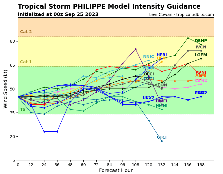
Wow, ECMWF for two runs in a row dissipates Philippe.
0 likes
Visit the Caribbean-Central America Weather Thread where you can find at first post web cams,radars
and observations from Caribbean basin members Click Here
and observations from Caribbean basin members Click Here


Re: ATL: PHILIPPE - Models
18z hurricane model runs:
- HWRF: 969.8 mb, 95.6 kt @ 114 hrs
- HMON: min pressure 992 mb, max wind around 45 kt
- HAFS-A: 984.9 mb, 66.7 kt @ 96 hrs; 984.0mb, 60.8 kt @ 120 hrs
- HAFS-B: 985.8 mb, 62.5 kt @ 123 hrs
- GFS: 978.9 mb, 68.1 kt @ 84 hrs; 975.7 mb, 68.0 kt @ 168 hrs
0 likes
Re: ATL: PHILIPPE - Models
cycloneye wrote:Wow, ECMWF for two runs in a row dissipates Philippe.
Euro seems to want to kill Philippe, but spin up the one behind it. And in doing so, that keeps the second one from getting pulled north.
GFS develops Philippe and that basically kills off the one behind it and pulls whatever remains of the second one north behind it. Its a pretty substantial difference for being inside the 5 day window.
1 likes
-
cycloneye
- Admin
- Posts: 139338
- Age: 67
- Joined: Thu Oct 10, 2002 10:54 am
- Location: San Juan, Puerto Rico
ATL: PHILIPPE - Tropical Storm - Discussion
They say GFS is an outlier.
There is a vast amount of spread in the
track models this morning with the GFS and its ensemble mean on the
far right side of the guidance envelope and the ECMWF on the left
side. An examination of the GFS model fields suggests that the
model is showing a vortex that is likely too vertically aligned, and
not representative of the environmental conditions. Therefore,
that model is considered an outlier for the time being.
0 likes
Visit the Caribbean-Central America Weather Thread where you can find at first post web cams,radars
and observations from Caribbean basin members Click Here
and observations from Caribbean basin members Click Here
Re: ATL: PHILIPPE - Models
Surprised nobody mentioned the overnight runs for this, such as it dipping into the Caribbean islands, Canadian actually making it dominant over 91L and recovering, and the Euro hinting it might recover over or north of the Bahamas. 6z GFS tries to get it going before moving into North Carolina. Heck even the forecast track animation for Phillipe https://www.nhc.noaa.gov/archive/2023/P ... e_and_wind is pretty high on the errors and is beginning to make me wonder if it's a sleeper backdoor type of system.


0 likes
-
Blown Away

- S2K Supporter

- Posts: 9867
- Joined: Wed May 26, 2004 6:17 am
Re: ATL: PHILIPPE - Models
It appears the remnants of Philippe make a comeback near the SE CONUS per the Euro...
1 likes
Hurricane Eye Experience: David 79, Irene 99, Frances 04, Jeanne 04, Wilma 05... EYE COMING MY WAY IN 2024…
Hurricane Brush Experience: Andrew 92, Erin 95, Floyd 99, Matthew 16, Irma 17, Ian 22, Nicole 22…
Hurricane Brush Experience: Andrew 92, Erin 95, Floyd 99, Matthew 16, Irma 17, Ian 22, Nicole 22…
Re: ATL: PHILIPPE - Models
BobHarlem wrote:Surprised nobody mentioned the overnight runs for this, such as it dipping into the Caribbean islands, Canadian actually making it dominant over 91L and recovering, and the Euro hinting it might recover over or north of the Bahamas. 6z GFS tries to get it going before moving into North Carolina. Heck even the forecast track animation for Phillipe https://www.nhc.noaa.gov/archive/2023/P ... e_and_wind is pretty high on the errors and is beginning to make me wonder if it's a sleeper backdoor type of system.
https://i.imgur.com/LdYlFgy.gif
https://i.imgur.com/1i4Q3oK.gif
The interaction between 91L and Phillipe is obviously key here. All the models seem to have Phillipe dying out and taking a southwest track into the northeastern Caribbean. But from there they diverge pretty wildly on which or 91L and Phillipe ends up being dominant and where either goes after that (it seems like the ones that keep Phillipe weaker tend to have it contributing to a coastal southeastern US low.)
1 likes
-
cycloneye
- Admin
- Posts: 139338
- Age: 67
- Joined: Thu Oct 10, 2002 10:54 am
- Location: San Juan, Puerto Rico
Re: ATL: PHILIPPE - Models
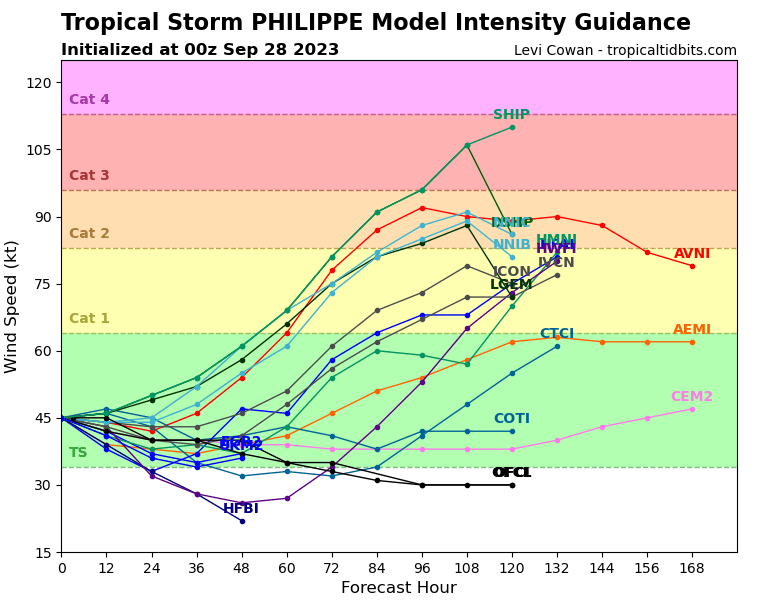
Huge change by GFS keeping Philippe strong.

0 likes
Visit the Caribbean-Central America Weather Thread where you can find at first post web cams,radars
and observations from Caribbean basin members Click Here
and observations from Caribbean basin members Click Here
-
cycloneye
- Admin
- Posts: 139338
- Age: 67
- Joined: Thu Oct 10, 2002 10:54 am
- Location: San Juan, Puerto Rico
Re: ATL: PHILIPPE - Models
0 likes
Visit the Caribbean-Central America Weather Thread where you can find at first post web cams,radars
and observations from Caribbean basin members Click Here
and observations from Caribbean basin members Click Here
-
MarioProtVI
- Category 2

- Posts: 671
- Age: 22
- Joined: Sun Sep 29, 2019 7:33 pm
- Location: New Jersey
Re: ATL: PHILIPPE - Models
12z euro is sending Philippe south of Hispaniola now, while the GFS is abrupt north turn. NHC may have to put up watches for the islands, I do NOT envy them on this setup.
3 likes

Re: ATL: PHILIPPE - Models
Phillipe eats 91L and bombs out into a major on the 18z GFS.
1 likes
Irene '11 Sandy '12 Hermine '16 5/15/2018 Derecho Fay '20 Isaias '20 Elsa '21 Henri '21 Ida '21
I am only a meteorology enthusiast who knows a decent amount about tropical cyclones. Look to the professional mets, the NHC, or your local weather office for the best information.
I am only a meteorology enthusiast who knows a decent amount about tropical cyclones. Look to the professional mets, the NHC, or your local weather office for the best information.
-
cycloneye
- Admin
- Posts: 139338
- Age: 67
- Joined: Thu Oct 10, 2002 10:54 am
- Location: San Juan, Puerto Rico
Re: ATL: PHILIPPE - Models
The more slower it moves, it favors the GFS scenario.
0 likes
Visit the Caribbean-Central America Weather Thread where you can find at first post web cams,radars
and observations from Caribbean basin members Click Here
and observations from Caribbean basin members Click Here
Re: ATL: PHILIPPE - Models
0z global models:
- GFS: Philippe bombs out on the recurve, 91L dies
- CMC: Both try to get going, but neither become anything more than A TS
- ICON: Missing frames on TT, but it seems to be Philippe that's bombing out on the recurve
1 likes

Re: ATL: PHILIPPE - Models
tomatkins wrote:BobHarlem wrote:Surprised nobody mentioned the overnight runs for this, such as it dipping into the Caribbean islands, Canadian actually making it dominant over 91L and recovering, and the Euro hinting it might recover over or north of the Bahamas. 6z GFS tries to get it going before moving into North Carolina. Heck even the forecast track animation for Phillipe https://www.nhc.noaa.gov/archive/2023/P ... e_and_wind is pretty high on the errors and is beginning to make me wonder if it's a sleeper backdoor type of system.
https://i.imgur.com/LdYlFgy.gif
https://i.imgur.com/1i4Q3oK.gif
The interaction between 91L and Phillipe is obviously key here. All the models seem to have Phillipe dying out and taking a southwest track into the northeastern Caribbean. But from there they diverge pretty wildly on which or 91L and Phillipe ends up being dominant and where either goes after that (it seems like the ones that keep Phillipe weaker tend to have it contributing to a coastal southeastern US low.)
Phillipe is a wacky one indeed, it does make me a bit concerned for the islands should he dip into the northern Caribbean and go over Hispaniola or PR. Sixty years ago around this same time, a hurricane named Flora meandered over Cuba and Hispaniola, causing a massive flood disaster over the area. Always worth keeping a close eye on something that gets into this area of the Carib in Late September into Early October. Definitely could be a sleeper IMO.
1 likes
Georges '98, Irene '99, Frances '04, Jeanne '04, Katrina '05, Wilma '05, Gustav '08, Isaac '12, Matthew '16, Florence '18, Michael '18, Ian '22
-
IsabelaWeather
- Tropical Storm

- Posts: 219
- Age: 34
- Joined: Tue Jul 07, 2020 7:29 am
- Location: Isabela, Puerto Rico
Re: ATL: PHILIPPE - Models
FireRat wrote:tomatkins wrote:BobHarlem wrote:Surprised nobody mentioned the overnight runs for this, such as it dipping into the Caribbean islands, Canadian actually making it dominant over 91L and recovering, and the Euro hinting it might recover over or north of the Bahamas. 6z GFS tries to get it going before moving into North Carolina. Heck even the forecast track animation for Phillipe https://www.nhc.noaa.gov/archive/2023/P ... e_and_wind is pretty high on the errors and is beginning to make me wonder if it's a sleeper backdoor type of system.
https://i.imgur.com/LdYlFgy.gif
https://i.imgur.com/1i4Q3oK.gif
The interaction between 91L and Phillipe is obviously key here. All the models seem to have Phillipe dying out and taking a southwest track into the northeastern Caribbean. But from there they diverge pretty wildly on which or 91L and Phillipe ends up being dominant and where either goes after that (it seems like the ones that keep Phillipe weaker tend to have it contributing to a coastal southeastern US low.)
Phillipe is a wacky one indeed, it does make me a bit concerned for the islands should he dip into the northern Caribbean and go over Hispaniola or PR. Sixty years ago around this same time, a hurricane named Flora meandered over Cuba and Hispaniola, causing a massive flood disaster over the area. Always worth keeping a close eye on something that gets into this area of the Carib in Late September into Early October. Definitely could be a sleeper IMO.
There is basically no chance it dips south and becomes a problem. We really need this storm to hit the island, NW PR is in a very bad drought right now and my reservoir has made zero appreciable gains this year. We are coming up to the dry season in mid november, if it doesnt fill up there are going to be massive issues.
https://waterdata.usgs.gov/monitoring-location/50010800/#parameterCode=72375&period=P365D&showMedian=true
0 likes

Re: ATL: PHILIPPE - Models
Teban54 wrote:0z global models:Not gonna stay up for the Euro, but 12z Euro favored 91L.
- GFS: Philippe bombs out on the recurve, 91L dies
- CMC: Both try to get going, but neither become anything more than A TS
- ICON: Missing frames on TT, but it seems to be Philippe that's bombing out on the recurve
Cantore this morning said he foresees Fujiwhara effect with these two.
0 likes
Cleo - 1964, Betsy - 1965, David - 1979, Andrew - 1992, Charlie (Francis, Ivan, Jeanne) - 2004, Irma - 2017, Ian - 2022
Who is online
Users browsing this forum: No registered users and 5 guests