EPAC: BEATRIZ - Remnants - Discussion

Moderator: S2k Moderators

Message
Author
User avatar
cycloneye
Admin
Admin
Posts: 139456
Age: 67
Joined: Thu Oct 10, 2002 10:54 am
Location: San Juan, Puerto Rico

Re: EPAC: BEATRIZ - Tropical Storm - Discussion

#41 Postby cycloneye » Thu Jun 29, 2023 4:04 pm

BULLETIN
Tropical Storm Beatriz Advisory Number 4
NWS National Hurricane Center Miami FL EP022023
400 PM CDT Thu Jun 29 2023

...TROPICAL STORM BEATRIZ FORMS OFF THE SOUTHERN COAST OF MEXICO...
...FORECAST TO RAPIDLY INTENSIFY, HURRICANE WARNING ISSUED FOR
PORTIONS OF THE SOUTHWESTERN COAST OF MEXICO...


SUMMARY OF 400 PM CDT...2100 UTC...INFORMATION
----------------------------------------------
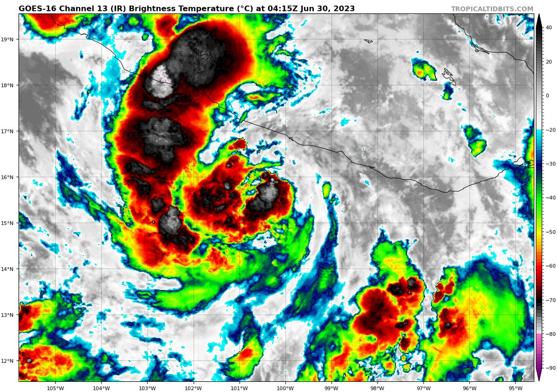
LOCATION...15.0N 99.4W
ABOUT 105 MI...170 KM SSW OF PUNTA MALDONADO MEXICO
ABOUT 135 MI...220 KM SSE OF ACAPULCO MEXICO
MAXIMUM SUSTAINED WINDS...40 MPH...65 KM/H
PRESENT MOVEMENT...WNW OR 300 DEGREES AT 12 MPH...19 KM/H
MINIMUM CENTRAL PRESSURE...1004 MB...29.65 INCHES


WATCHES AND WARNINGS
--------------------
CHANGES WITH THIS ADVISORY:

The government of Mexico has issued a Hurricane Warning from
Zihuatanejo to Playa Perula. A Tropical Storm Watch has been
issued north of Cabo Corrientes to Punta Mita.

SUMMARY OF WATCHES AND WARNINGS IN EFFECT:

A Hurricane Warning is in effect for...
* Zihuatanejo to Playa Perula Mexico

A Hurricane Watch is in effect for...
* North of Playa Perula to Cabo Corrientes Mexico

A Tropical Storm Warning is in effect for...
* South of Zihuatanejo to Punta Maldonado Mexico

A Tropical Storm Watch is in effect for...
* North of Cabo Corrientes to Punta Mita Mexico


Tropical Storm Beatriz Discussion Number 4
NWS National Hurricane Center Miami FL EP022023
400 PM CDT Thu Jun 29 2023

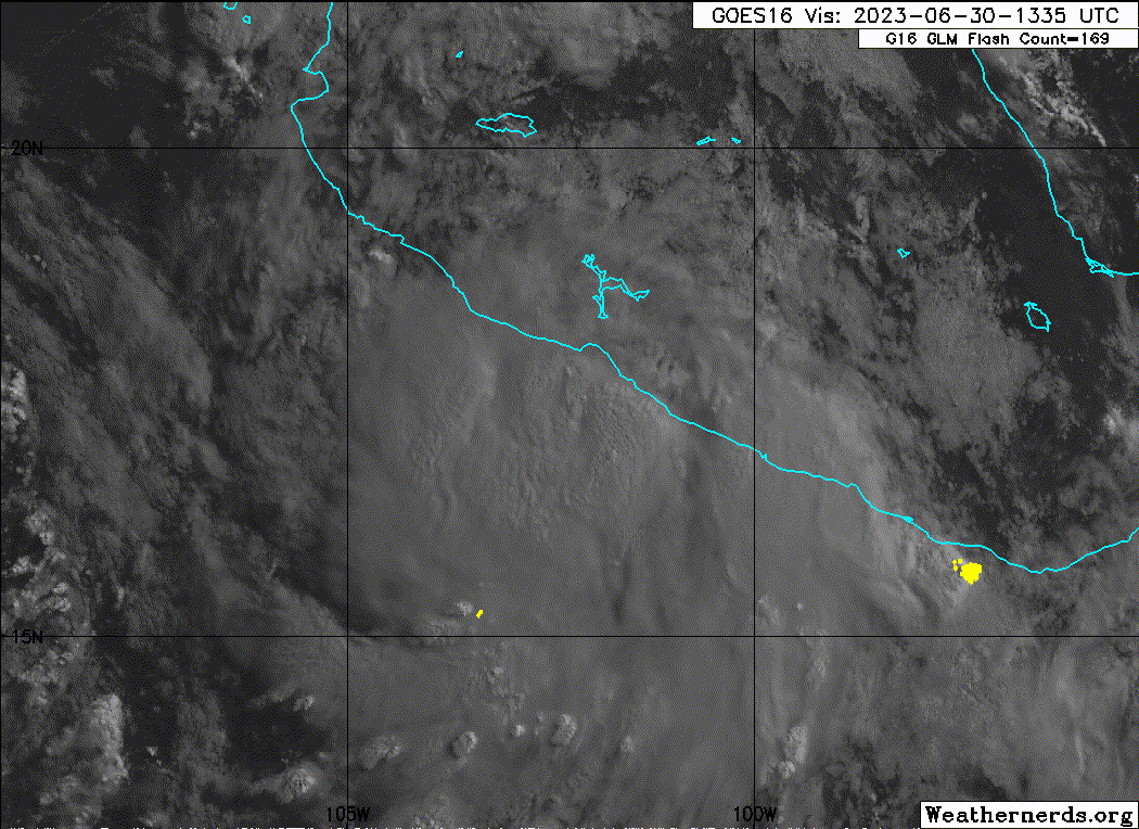
The cyclone's satellite presentation, at least in visible imagery,
has improved markedly through the day, and the low-level center had
become apparent in a relatively cloud-free region (which has
recently become obscured) surrounded by developing deep convection.
Dvorak satellite intensity estimates are T2.5/35 kt from TAFB and
T2.0/30 kt from SAB (with similar objective numbers), so the initial
intensity is raised to 35 kt, with the cyclone now designated as
Tropical Storm Beatriz.

Beatriz is moving toward the west-northwest, or 300/10 kt, along
the southern periphery of a mid-level ridge located over northern
Mexico. This ridge is forecast to weaken a bit during the next few
days, and Beatriz is therefore expected to move northwestward for
the next 4 days or so. The track guidance has continued to shift
to the right, closer to the coast of Mexico, and some models (in
particular the ECMWF and HCCA) bring the center inland in about
24-36 hours. The NHC track forecast has been shifted to the east as
well, and now shows the center of Beatriz grazing the coasts of
Michoacan, Colima, and Jalisco in the next 24-48 hours. It is
important to remember that Beatriz's oblique angle of approach to
the southwestern coast of Mexico makes it difficult to know exactly
where the center might come onshore, if at all, and therefore a
larger-than-normal part of the coastline is at risk of some effects
from the storm.

Beatriz is now expected to rapidly intensify during the next 24
hours in an environment of low shear and abundant moisture, and
over very warm waters of 30-31 degrees Celsius. Following the
trend from this morning, the intensity guidance shows significant
strengthening in the short term, and the NHC intensity forecast has
been raised to the high end of the guidance, closest to the HAFS-A
and HCCA solutions at 24 hours. After that time, Beatriz's
intensity will largely depend on if the center reaches land. Based
on the official track forecast's proximity to land, intensification
is shown through 36 hours, with weakening thereafter. Faster
weakening is anticipated near the end of the forecast period due to
drier air and cooler sea surface temperatures, and global model
guidance suggests that Beatriz could degenerate into a remnant low
by day 5, if not sooner.


KEY MESSAGES:

1. Beatriz is forecast to rapidly intensify and become a hurricane
on Friday, bringing a risk of hurricane-force winds and a dangerous
storm surge to portions of the southwestern coast of Mexico during
the next couple of days. A Hurricane Warning is now in effect for
portions of the coasts of Guerrero, Michoacan, Colima, and Jalisco,
and hurricane conditions are expected somewhere in those areas
Friday and Saturday.

2. Locally heavy rainfall is expected across southern Mexico from
the state of Oaxaca westward to the state of Jalisco. These rains
could lead to life-threatening flash flooding and mudslides.


FORECAST POSITIONS AND MAX WINDS

INIT 29/2100Z 15.0N 99.4W 35 KT 40 MPH
12H 30/0600Z 15.9N 100.7W 50 KT 60 MPH
24H 30/1800Z 17.2N 102.4W 65 KT 75 MPH
36H 01/0600Z 18.7N 104.1W 70 KT 80 MPH
48H 01/1800Z 20.0N 105.7W 60 KT 70 MPH
60H 02/0600Z 20.8N 106.7W 55 KT 65 MPH
72H 02/1800Z 21.6N 107.6W 45 KT 50 MPH
96H 03/1800Z 22.5N 109.1W 35 KT 40 MPH
120H 04/1800Z 23.5N 111.5W 20 KT 25 MPH...POST-TROP/REMNT LOW

$$
Forecaster Berg


Image
0 likes   
Visit the Caribbean-Central America Weather Thread where you can find at first post web cams,radars
and observations from Caribbean basin members Click Here

User avatar
Yellow Evan
Professional-Met
Professional-Met
Posts: 15959
Age: 25
Joined: Fri Jul 15, 2011 12:48 pm
Location: Henderson, Nevada/Honolulu, HI
Contact:

Re: EPAC: BEATRIZ - Tropical Storm - Discussion

#42 Postby Yellow Evan » Thu Jun 29, 2023 6:58 pm

GFS, HAFSA, and HAFSB seemed to insist on pretty explosive intensification in the next 24 hours, exceeding 75 knots at peak. Upper-environment is only decent and the storm does not have central convection so I am skeptical, though it is over some of the warmest waters in the planet.
0 likes   

Sciencerocks
Category 5
Category 5
Posts: 7292
Age: 38
Joined: Thu Jul 06, 2017 1:51 am

Re: EPAC: BEATRIZ - Tropical Storm - Discussion

#43 Postby Sciencerocks » Thu Jun 29, 2023 7:29 pm

Image
0 likes   

User avatar
cycloneye
Admin
Admin
Posts: 139456
Age: 67
Joined: Thu Oct 10, 2002 10:54 am
Location: San Juan, Puerto Rico

Re: EPAC: BEATRIZ - Tropical Storm - Discussion

#44 Postby cycloneye » Thu Jun 29, 2023 8:35 pm

Is some dry air penetrated? Doesn't look great now.

Image
0 likes   
Visit the Caribbean-Central America Weather Thread where you can find at first post web cams,radars
and observations from Caribbean basin members Click Here

User avatar
cycloneye
Admin
Admin
Posts: 139456
Age: 67
Joined: Thu Oct 10, 2002 10:54 am
Location: San Juan, Puerto Rico

Re: EPAC: BEATRIZ - Tropical Storm - Discussion

#45 Postby cycloneye » Thu Jun 29, 2023 9:42 pm

BULLETIN
Tropical Storm Beatriz Advisory Number 5
NWS National Hurricane Center Miami FL EP022023
1000 PM CDT Thu Jun 29 2023

...BEATRIZ EXPECTED TO BEGIN TO RAPIDLY INTENSIFY SOON...
...WILL BRING HEAVY RAINS AND STRONG WINDS TO THE SOUTHWEST COAST
OF MEXICO...


SUMMARY OF 1000 PM CDT...0300 UTC...INFORMATION
-----------------------------------------------
LOCATION...15.5N 100.3W
ABOUT 100 MI...160 KM SSW OF ACAPULCO MEXICO
MAXIMUM SUSTAINED WINDS...40 MPH...65 KM/H
PRESENT MOVEMENT...WNW OR 300 DEGREES AT 12 MPH...19 KM/H
MINIMUM CENTRAL PRESSURE...1004 MB...29.65 INCHES


Tropical Storm Beatriz Discussion Number 5
NWS National Hurricane Center Miami FL EP022023
1000 PM CDT Thu Jun 29 2023

Beatriz is still in the organizing stage at this time. Some
convective banding features are starting to develop near and west
of the estimated center location. Although the outer cloud
structure is becoming better defined, deep convection is
currently not very strong near the center. Dvorak satellite
intensity estimates from SAB and TAFB remain at 30 and 35 kt
respectively, so the intensity is held at 35 kt for this advisory.

Although the center is not that easy to locate, the latest center
fixes indicate that the motion is west-northwestward, or 300/10 kt.
Over the next few days, a mid-level ridge to the north and northeast
of Beatriz should steer the cyclone on a generally northwestward
heading. There continues to be significant difference among the
track models, however, with the HAFS and ECMWF models bringing the
center onshore in 36-48 hours and the GFS, HWRF, and HMON
guidance keeping the core of Beatriz offshore. The official
forecast is similar to the previous one and shows the center on the
coast in the 36-hour time frame, in closer agreement with the ECMWF
solution. It is important to note that Beatriz's oblique angle of
approach to the southwestern coast of Mexico makes it difficult to
know exactly where the center might come onshore, if at all, and
therefore a larger-than-normal part of the coastline is at risk of
some effects from the storm. Over the weekend the ridge weakens,
and the forward motion of Beatriz is likely to slow.

The atmospheric and oceanic environment for Beatriz appears to be
quite conducive for strengthening, with low vertical shear, high
mid-level humidity, and SSTs near 30 deg C. The SHIP rapid
intensification (RI) indices show a greater than normal chance for
RI during the next day or so, and the official forecast calls for
Beatriz to become a hurricane in just 24 hours. This is on the
high side of the intensity model guidance. The cyclone's intensity
in 36-48 hours will be dependent on how much the system interacts
with land. At this time, the official forecast calls for at least
some land interaction and weakening in a couple of days. Later in
the forecast period, drier air and cooler waters are expected to
cause weakening, and the model guidance indicates that Beatriz will
degenerate into a remnant low by day 5.


KEY MESSAGES:

1. Beatriz is forecast to rapidly intensify and become a hurricane
later on Friday, bringing a risk of hurricane-force winds and a
dangerous storm surge to portions of the southwestern coast of
Mexico during the next couple of days. A Hurricane Warning is now
in effect for portions of the coasts of Guerrero, Michoacan, Colima,
and Jalisco, and hurricane conditions are expected somewhere in
those areas Friday and Saturday.

2. Locally heavy rainfall is expected across southern Mexico from
the state of Oaxaca westward to the state of Jalisco. These rains
could lead to life-threatening flash flooding and mudslides.


FORECAST POSITIONS AND MAX WINDS

INIT 30/0300Z 15.5N 100.3W 35 KT 40 MPH
12H 30/1200Z 16.5N 101.5W 50 KT 60 MPH
24H 01/0000Z 17.9N 103.2W 65 KT 75 MPH
36H 01/1200Z 19.3N 104.9W 70 KT 80 MPH...ON COAST
48H 02/0000Z 20.1N 106.0W 60 KT 70 MPH
60H 02/1200Z 21.0N 107.2W 55 KT 65 MPH
72H 03/0000Z 21.5N 108.0W 45 KT 50 MPH
96H 04/0000Z 22.1N 109.4W 35 KT 40 MPH
120H 05/0000Z 23.0N 112.0W 20 KT 25 MPH...POST-TROP/REMNT LOW

$$
Forecaster Pasch
0 likes   
Visit the Caribbean-Central America Weather Thread where you can find at first post web cams,radars
and observations from Caribbean basin members Click Here

Sciencerocks
Category 5
Category 5
Posts: 7292
Age: 38
Joined: Thu Jul 06, 2017 1:51 am

Re: EPAC: BEATRIZ - Tropical Storm - Discussion

#46 Postby Sciencerocks » Thu Jun 29, 2023 9:46 pm

Image
0 likes   

User avatar
Kingarabian
S2K Supporter
S2K Supporter
Posts: 15454
Joined: Sat Aug 08, 2009 3:06 am
Location: Honolulu, Hawaii

Re: EPAC: BEATRIZ - Tropical Storm - Discussion

#47 Postby Kingarabian » Thu Jun 29, 2023 11:30 pm

That's a mean feeder band. If it can get some sort of core/cdo going it can become a major.
Image
0 likes   
RIP Kobe Bryant

User avatar
ElectricStorm
Category 5
Category 5
Posts: 4617
Age: 23
Joined: Tue Aug 13, 2019 11:23 pm
Location: Skiatook, OK / Norman, OK

Re: EPAC: BEATRIZ - Tropical Storm - Discussion

#48 Postby ElectricStorm » Fri Jun 30, 2023 12:04 am

Looks like it's starting to build a CDO pretty quickly now, I think we'll see some RI soon.
0 likes   
I am in no way a professional. Take what I say with a grain of salt as I could be totally wrong. Please refer to the NHC, NWS, or SPC for official information.

Boomer Sooner!

User avatar
ElectricStorm
Category 5
Category 5
Posts: 4617
Age: 23
Joined: Tue Aug 13, 2019 11:23 pm
Location: Skiatook, OK / Norman, OK

Re: EPAC: BEATRIZ - Tropical Storm - Discussion

#49 Postby ElectricStorm » Fri Jun 30, 2023 12:50 am

BULLETIN
Tropical Storm Beatriz Intermediate Advisory Number 5A
NWS National Hurricane Center Miami FL EP022023
100 AM CDT Fri Jun 30 2023

...BEATRIZ NOW INTENSIFYING...
...WILL BRING HEAVY RAINS AND STRONG WINDS TO THE SOUTHWEST COAST
OF MEXICO...


SUMMARY OF 100 AM CDT...0600 UTC...INFORMATION
----------------------------------------------
LOCATION...15.9N 100.9W
ABOUT 95 MI...155 KM SW OF ACAPULCO MEXICO
MAXIMUM SUSTAINED WINDS...50 MPH...80 KM/H
PRESENT MOVEMENT...WNW OR 300 DEGREES AT 12 MPH...19 KM/H
MINIMUM CENTRAL PRESSURE...1001 MB...29.56 INCHES
0 likes   
I am in no way a professional. Take what I say with a grain of salt as I could be totally wrong. Please refer to the NHC, NWS, or SPC for official information.

Boomer Sooner!

User avatar
cycloneye
Admin
Admin
Posts: 139456
Age: 67
Joined: Thu Oct 10, 2002 10:54 am
Location: San Juan, Puerto Rico

Re: EPAC: BEATRIZ - Tropical Storm - Discussion

#50 Postby cycloneye » Fri Jun 30, 2023 3:46 am

BULLETIN
Tropical Storm Beatriz Advisory Number 6
NWS National Hurricane Center Miami FL EP022023
400 AM CDT Fri Jun 30 2023

...BEATRIZ WILL BRING HEAVY RAINS AND STRONG WINDS TO THE SOUTHWEST
COAST OF MEXICO...
...NEW WARNINGS AND WATCHES ISSUED FOR PORTIONS OF THE COAST OF
MEXICO...


SUMMARY OF 400 AM CDT...0900 UTC...INFORMATION
----------------------------------------------
LOCATION...16.3N 101.3W
ABOUT 100 MI...165 KM WSW OF ACAPULCO MEXICO
ABOUT 270 MI...435 KM SE OF MANZANILLO MEXICO
MAXIMUM SUSTAINED WINDS...60 MPH...95 KM/H
PRESENT MOVEMENT...NW OR 305 DEGREES AT 13 MPH...20 KM/H
MINIMUM CENTRAL PRESSURE...997 MB...29.44 INCHES


WATCHES AND WARNINGS
--------------------
CHANGES WITH THIS ADVISORY:

The Government of Mexico has issued a Hurricane Warning for the
Pacific coast of Mexico from Playa Perula to Cabo Corrientes.

The Government of Mexico has also issued a Hurricane Watch and a
Tropical Storm Warning for the Pacific coast of Mexico north of
Cabo Corrientes to Punta Mita, and a Tropical Storm Watch for
the Pacific coast of Mexico north of Punta Mita to San Blas.

The Government of Mexico has discontinued the Tropical Storm
Warning for the Pacific coast of Mexico east of Acapulco.

SUMMARY OF WATCHES AND WARNINGS IN EFFECT:

A Hurricane Warning is in effect for...
* Zihuatanejo to Cabo Corrientes Mexico

A Hurricane Watch is in effect for...
* North of Cabo Corrientes to Punta Mita Mexico

A Tropical Storm Warning is in effect for...
* South of Zihuatanejo to Acapulco Mexico
* North of Cabo Corrientes to Punta Mita Mexico

A Tropical Storm Watch is in effect for...
* North of Punta Mita to San Blas Mexico

Tropical Storm Beatriz Discussion Number 6
NWS National Hurricane Center Miami FL EP022023
400 AM CDT Fri Jun 30 2023

The convective pattern associated with Beatriz has become more
concentrated since the last advisory, with stronger convection near
the center and more convective banding. Two ASCAT overpasses back
around 04Z showed winds of 45-50 kt located about 20 n mi to the
northeast of the center. Based on this data and the increase in
organization since that time, the initial intensity is increased to
a possibly conservative 50 kt.

The initial motion is now 305/11 kt. During the next several days,
a combination of a mid-level ridge to the north-northeast and
Hurricane Adrian to the west should steer Beatriz generally
northwestward. While the models generally agree with this scenario,
there are important differences among them on how close Beatriz will
get to the coast of Mexico. The GFS and the HWRF are on the left
side of the guidance envelope and keep the center a significant
distance offshore. On the other hand, the ECMWF, the UKMET, and the
Canadian models all bring the center onshore in western Mexico in
24-36 h. The early part of the new track forecast keeps the center
just offshore of the coast through 36 h as a blend of the previous
forecast and the HFIP Corrected Consensus model. However, any
motion to the right of the track would result in Beatriz making
landfall in Mexico. The remainder of the forecast track shows
Beatriz slowing its forward motion and turning more toward the west
in response to mid-level ridging to the north, with the center
passing south or near the southern end of the Baja California
peninsula.

Beatriz is in an area of light- to moderate northeasterly shear and
over very warm sea surface temperatures. Based on these conditions,
and on the inner core convective structure seen earlier in 37-GHz
microwave imagery, steady to rapid intensification is expected
during the next 24 h as long as the center stays offshore. Beatriz
is expected to become a hurricane later today and maintain hurricane
strength through 48 h. After that time, decreasing sea surface
temperatures along the forecast track should lead to weakening, with
the system currently forecast to decay to a remnant low by 120 h.
If the center moves inland over Mexico, the mountainous terrain
should cause rapid weakening, and Beatriz, if it survives, would be
much weaker than currently forecast.


KEY MESSAGES:

1. Beatriz is forecast to rapidly intensify and become a hurricane
later today, bringing a risk of hurricane-force winds and a
dangerous storm surge to portions of the southwestern coast of
Mexico during the next couple of days. A Hurricane Warning is now
in effect for portions of the coasts of Guerrero, Michoacan, Colima,
and Jalisco, and hurricane conditions are expected somewhere in
those areas later today and on Saturday.

2. Locally heavy rainfall is expected across southern Mexico from
the state of Oaxaca westward to the state of Nayarit. These rains
could lead to life-threatening flash flooding and mudslides.


FORECAST POSITIONS AND MAX WINDS

INIT 30/0900Z 16.3N 101.3W 50 KT 60 MPH
12H 30/1800Z 17.3N 102.7W 65 KT 75 MPH
24H 01/0600Z 18.7N 104.4W 70 KT 80 MPH
36H 01/1800Z 20.0N 106.0W 70 KT 80 MPH
48H 02/0600Z 21.0N 107.3W 65 KT 75 MPH
60H 02/1800Z 21.7N 108.4W 60 KT 70 MPH
72H 03/0600Z 22.1N 109.2W 55 KT 65 MPH
96H 04/0600Z 22.5N 111.0W 35 KT 40 MPH
120H 05/0600Z 23.0N 113.0W 20 KT 25 MPH...POST-TROP/REMNT LOW

$$
Forecaster Beven
0 likes   
Visit the Caribbean-Central America Weather Thread where you can find at first post web cams,radars
and observations from Caribbean basin members Click Here

User avatar
Yellow Evan
Professional-Met
Professional-Met
Posts: 15959
Age: 25
Joined: Fri Jul 15, 2011 12:48 pm
Location: Henderson, Nevada/Honolulu, HI
Contact:

Re: EPAC: BEATRIZ - Tropical Storm - Discussion

#51 Postby Yellow Evan » Fri Jun 30, 2023 4:09 am

Kingarabian wrote:That's a mean feeder band. If it can get some sort of core/cdo going it can become a major.
https://i.postimg.cc/yY5f2hvz/image.png


Given how close this is to Mexico and the time of day, this is likely added by nightitme downslope flow. Almost certain to recede once the diurnal cycle reverses.
0 likes   

User avatar
Yellow Evan
Professional-Met
Professional-Met
Posts: 15959
Age: 25
Joined: Fri Jul 15, 2011 12:48 pm
Location: Henderson, Nevada/Honolulu, HI
Contact:

Re: EPAC: BEATRIZ - Tropical Storm - Discussion

#52 Postby Yellow Evan » Fri Jun 30, 2023 4:12 am

KMNI ASCAT supports 48 knots but given low bias established in Chou 2013 and the small RMW here, you could argue for as high as 60 knots.
0 likes   

Sciencerocks
Category 5
Category 5
Posts: 7292
Age: 38
Joined: Thu Jul 06, 2017 1:51 am

Re: EPAC: BEATRIZ - Tropical Storm - Discussion

#53 Postby Sciencerocks » Fri Jun 30, 2023 6:14 am

Image
0 likes   

User avatar
aspen
Category 5
Category 5
Posts: 8059
Joined: Sat Oct 12, 2019 7:10 pm
Location: Connecticut, USA

Re: EPAC: BEATRIZ - Tropical Storm - Discussion

#54 Postby aspen » Fri Jun 30, 2023 9:36 am

I think I see an eye forming. Good thing we have recon en route to check things out.
0 likes   
Irene '11 Sandy '12 Hermine '16 5/15/2018 Derecho Fay '20 Isaias '20 Elsa '21 Henri '21 Ida '21

I am only a meteorology enthusiast who knows a decent amount about tropical cyclones. Look to the professional mets, the NHC, or your local weather office for the best information.

User avatar
cycloneye
Admin
Admin
Posts: 139456
Age: 67
Joined: Thu Oct 10, 2002 10:54 am
Location: San Juan, Puerto Rico

Re: EPAC: BEATRIZ - Tropical Storm - Discussion

#55 Postby cycloneye » Fri Jun 30, 2023 9:46 am

Image
0 likes   
Visit the Caribbean-Central America Weather Thread where you can find at first post web cams,radars
and observations from Caribbean basin members Click Here

User avatar
cycloneye
Admin
Admin
Posts: 139456
Age: 67
Joined: Thu Oct 10, 2002 10:54 am
Location: San Juan, Puerto Rico

Re: EPAC: BEATRIZ - Hurricane - Discussion

#56 Postby cycloneye » Fri Jun 30, 2023 10:10 am

TCPEP2

BULLETIN
Hurricane Beatriz Advisory Number 7
NWS National Hurricane Center Miami FL EP022023
1000 AM CDT Fri Jun 30 2023

...BEATRIZ BECOMES A HURRICANE...
...STRONG WINDS AND HEAVY RAINS EXPECTED ALONG PORTIONS OF THE
SOUTHWESTERN COAST OF MEXICO THROUGH SATURDAY...


SUMMARY OF 1000 AM CDT...1500 UTC...INFORMATION
-----------------------------------------------
LOCATION...17.3N 102.3W
ABOUT 50 MI...80 KM S OF LAZARO CARDENAS MEXICO
ABOUT 175 MI...285 KM SE OF MANZANILLO MEXICO
MAXIMUM SUSTAINED WINDS...75 MPH...120 KM/H
PRESENT MOVEMENT...NW OR 310 DEGREES AT 13 MPH...20 KM/H
MINIMUM CENTRAL PRESSURE...991 MB...29.27 INCHES


WATCHES AND WARNINGS
--------------------
CHANGES WITH THIS ADVISORY:

The government of Mexico has issued a Tropical Storm Watch for Las
Islas Marias. The Tropical Storm Warning south of Tecpan de
Galeana has been discontinued.

SUMMARY OF WATCHES AND WARNINGS IN EFFECT:

A Hurricane Warning is in effect for...
* Zihuatanejo to Cabo Corrientes Mexico

A Hurricane Watch is in effect for...
* North of Cabo Corrientes to Punta Mita Mexico

A Tropical Storm Warning is in effect for...
* South of Zihuatanejo to Tecpan de Galeana Mexico
* North of Cabo Corrientes to Punta Mita Mexico

A Tropical Storm Watch is in effect for...
* North of Punta Mita to San Blas Mexico
* Las Islas Marias


Hurricane Beatriz Discussion Number 7
NWS National Hurricane Center Miami FL EP022023
1000 AM CDT Fri Jun 30 2023

Recent GOES 1-minute visible and infrared satellite imagery show
that an eye is forming. A special classification from TAFB yielded
an estimate of T4.0/65 kt, and raw UW-CIMSS ADT values are also up
to 4.0. Therefore, Beatriz has been upgraded to a hurricane with
maximum winds estimated to be 65 kt. An Air Force Reserve Hurricane
plane is scheduled to investigate the storm in a few hours,
hopefully providing a refinement in the estimated intensity.

Beatriz's initial motion remains northwestward, or 305/11 kt. The
storm is expected to continue moving northwestward during the next
48 hours as it moves along the southwestern periphery of a
mid-level ridge located over the southern United States and
northern Mexico. However, as is often the case with cyclones
paralleling the west coast of Mexico, there is significant
uncertainty as to whether Beatriz's center will continue to skirt
the coast or move inland at some point. The NHC track forecast
continues to show a scenario where Beatriz grazes the coast during
the next 24-36 hours, but models such as the ECMWF and UKMET do
bring the system inland and show dissipation. If Beatriz survives
the next 48 hours, it would then likely slow down and turn toward
the west-northwest as a mid-level ridge builds over the
southwestern U.S.

If Beatriz's center remains offshore, environmental conditions
should otherwise be conducive for additional strengthening during
the next 12-24 hours, and the storm is forecast to remain a
hurricane until after it passes Cabo Corrientes. On the other hand,
if the center reaches land, the mountainous terrain of Mexico would
likely cause rapid weakening. Assuming survival during the next 36
hours, increasing shear out of the east-northeast, cooler sea
surface temperatures, and a drier, more subsident environment would
likely lead to gradual weakening on days 2 and 3. Based on the
latest global model guidance, Beatriz is likely to have degenerated
into a remnant low by day 4 and dissipate by day 5.


KEY MESSAGES:

1. Beatriz is forecast to continue strengthening and remain a
hurricane through Saturday, bringing a risk of hurricane-force
winds and a dangerous storm surge to portions of the southwestern
coast of Mexico during the next day or so. A Hurricane Warning is
in effect for portions of the coasts of Guerrero, Michoacan, Colima,
and Jalisco, and hurricane conditions are expected somewhere in
those areas later today and on Saturday.

2. Locally heavy rainfall is expected across southern Mexico from
the state of Oaxaca westward to the state of Nayarit. These rains
could lead to life-threatening flash flooding and mudslides.


FORECAST POSITIONS AND MAX WINDS

INIT 30/1500Z 17.3N 102.3W 65 KT 75 MPH
12H 01/0000Z 18.2N 103.4W 70 KT 80 MPH
24H 01/1200Z 19.4N 105.1W 70 KT 80 MPH
36H 02/0000Z 20.4N 106.6W 65 KT 75 MPH
48H 02/1200Z 21.3N 107.8W 60 KT 70 MPH
60H 03/0000Z 21.7N 108.7W 50 KT 60 MPH
72H 03/1200Z 22.0N 109.4W 40 KT 45 MPH
96H 04/1200Z 22.6N 111.2W 30 KT 35 MPH...POST-TROP/REMNT LOW
120H 05/1200Z...DISSIPATED

$$
Forecaster Berg
0 likes   
Visit the Caribbean-Central America Weather Thread where you can find at first post web cams,radars
and observations from Caribbean basin members Click Here

User avatar
Yellow Evan
Professional-Met
Professional-Met
Posts: 15959
Age: 25
Joined: Fri Jul 15, 2011 12:48 pm
Location: Henderson, Nevada/Honolulu, HI
Contact:

Re: EPAC: BEATRIZ - Hurricane - Discussion

#57 Postby Yellow Evan » Fri Jun 30, 2023 10:32 am

Image
0 likes   

Sciencerocks
Category 5
Category 5
Posts: 7292
Age: 38
Joined: Thu Jul 06, 2017 1:51 am

Re: EPAC: BEATRIZ - Hurricane - Discussion

#58 Postby Sciencerocks » Fri Jun 30, 2023 12:01 pm

Image
0 likes   

User avatar
cycloneye
Admin
Admin
Posts: 139456
Age: 67
Joined: Thu Oct 10, 2002 10:54 am
Location: San Juan, Puerto Rico

Re: EPAC: BEATRIZ - Hurricane - Discussion

#59 Postby cycloneye » Fri Jun 30, 2023 12:59 pm

BULLETIN
Hurricane Beatriz Intermediate Advisory Number 7A
NWS National Hurricane Center Miami FL EP022023
100 PM CDT Fri Jun 30 2023

...BEATRIZ CONTINUES TO STRENGTHEN...
...CONDITIONS DETERIORATING ALONG THE COAST OF MICHOACAN...


SUMMARY OF 100 PM CDT...1800 UTC...INFORMATION
----------------------------------------------
LOCATION...17.5N 102.6W
ABOUT 45 MI...70 KM SW OF LAZARO CARDENAS MEXICO
ABOUT 150 MI...245 KM SE OF MANZANILLO MEXICO
MAXIMUM SUSTAINED WINDS...80 MPH...130 KM/H
PRESENT MOVEMENT...NW OR 310 DEGREES AT 13 MPH...20 KM/H
MINIMUM CENTRAL PRESSURE...992 MB...29.29 INCHES


WATCHES AND WARNINGS
--------------------
CHANGES WITH THIS ADVISORY:

None.

SUMMARY OF WATCHES AND WARNINGS IN EFFECT:

A Hurricane Warning is in effect for...
* Zihuatanejo to Cabo Corrientes Mexico

A Hurricane Watch is in effect for...
* North of Cabo Corrientes to Punta Mita Mexico

A Tropical Storm Warning is in effect for...
* South of Zihuatanejo to Tecpan de Galeana Mexico
* North of Cabo Corrientes to Punta Mita Mexico

A Tropical Storm Watch is in effect for...
* North of Punta Mita to San Blas Mexico
* Las Islas Marias

A Hurricane Warning means that hurricane conditions are expected
somewhere within the warning area. A warning is typically issued
36 hours before the anticipated first occurrence of
tropical-storm-force winds, conditions that make outside
preparations difficult or dangerous. Preparations to protect life
and property should be rushed to completion.

A Hurricane Watch means that hurricane conditions are possible
within the watch area, in this case within the next 24 to 36 hours.

A Tropical Storm Warning means that tropical storm conditions are
expected somewhere within the warning area within 36 hours.

A Tropical Storm Watch means that tropical storm conditions are
possible within the watch area, generally within 48 hours.

Interests elsewhere along the west-central coast of Mexico and in
the southern portion of the Baja California peninsula should
monitor the progress of this system. Additional watches or
warnings may be required later today or on Saturday.

For storm information specific to your area, please monitor
products issued by your national meteorological service.


DISCUSSION AND OUTLOOK
----------------------
At 100 PM CDT (1800 UTC), the center of Hurricane Beatriz was
located by an Air Force Reserve Hurricane Hunter aircraft near
latitude 17.5 North, longitude 102.6 West. Beatriz is moving toward
the northwest near 13 mph (20 km/h), and this motion with some
decrease in forward speed is expected through early Sunday. A turn
toward the west-northwest with an additional decrease in forward
speed is expected on Sunday. On the forecast track, the center of
Beatriz is expected to move near or over portions of the coast of
southwestern Mexico later today through Saturday. Beatriz is then
expected to move away from the west-central coast of Mexico
Saturday night and Sunday.

Preliminary reconnaissance reports and recent satellite images
indicate that Beatriz continues to strengthen, and maximum sustained
winds have increased to near 80 mph (130 km/h) with higher gusts.
Additional strengthening is possible today and tonight if Beatriz's
center remains over water. Weakening is expected to begin on Sunday.

Hurricane-force winds extend outward up to 10 miles (20 km) from
the center and tropical-storm-force winds extend outward up to 70
miles (110 km).

The minimum central pressure reported by aircraft data is 992 mb
(29.29 inches).
0 likes   
Visit the Caribbean-Central America Weather Thread where you can find at first post web cams,radars
and observations from Caribbean basin members Click Here

User avatar
Yellow Evan
Professional-Met
Professional-Met
Posts: 15959
Age: 25
Joined: Fri Jul 15, 2011 12:48 pm
Location: Henderson, Nevada/Honolulu, HI
Contact:

Re: EPAC: BEATRIZ - Hurricane - Discussion

#60 Postby Yellow Evan » Fri Jun 30, 2023 1:51 pm

EP, 02, 2023063018, , BEST, 0, 175N, 1027W, 75, 992, HU, 64, NEQ, 20, 15, 10, 20, 1009, 90, 10, 0, 0, E, 0, , 0, 0, BEATRIZ, D,
0 likes   


Return to “2023”

Who is online

Users browsing this forum: No registered users and 6 guests