ATL: TAMMY - Post-Tropical - Discussion
Moderator: S2k Moderators
-
MarioProtVI
- Category 2

- Posts: 671
- Age: 22
- Joined: Sun Sep 29, 2019 7:33 pm
- Location: New Jersey
Re: ATL: INVEST 94L - Discussion
94L is rapidly organizing faster then I anticipated, and is likely close to becoming a TC and will likely do so later today if it keeps this up. With the GFS, CMC, ICON and the EURO (00z is also likely strong seeing how 18z uptrended) plus the ensembles all beginning to agree on at least a Cat 2, we could be heading for unprecedented territory here - and I don’t think they’re bluffing seeing as this consensus was very reminiscent of Lee last month.
2 likes
-
ElectricStorm

- Category 5

- Posts: 4597
- Age: 23
- Joined: Tue Aug 13, 2019 11:23 pm
- Location: Skiatook, OK / Norman, OK
Re: ATL: INVEST 94L - Discussion
1. Eastern Tropical Atlantic (AL94):
Shower and thunderstorm activity associated with an area of low
pressure located several hundred miles southwest of the Cabo Verde
Islands has increased overnight and is showing signs of
organization. Environmental conditions are expected to become
more conducive for development this weekend and early next week,
and a tropical depression is likely to form within the next few
days while the system moves westward or west-northwestward across
the central and western tropical Atlantic.
* Formation chance through 48 hours...medium...60 percent.
* Formation chance through 7 days...high...80 percent.
1 likes
I am in no way a professional. Take what I say with a grain of salt as I could be totally wrong. Please refer to the NHC, NWS, or SPC for official information.
Boomer Sooner!
Boomer Sooner!


Re: ATL: INVEST 94L - Discussion
MarioProtVI wrote:94L is rapidly organizing faster then I anticipated, and is likely close to becoming a TC and will likely do so later today if it keeps this up. With the GFS, CMC, ICON and the EURO (00z is also likely strong seeing how 18z uptrended) plus the ensembles all beginning to agree on at least a Cat 2, we could be heading for unprecedented territory here - and I don’t think they’re bluffing seeing as this consensus was very reminiscent of Lee last month.
Already starting to get that classic shrimp look:

4 likes
-
MarioProtVI
- Category 2
- Posts: 671
- Age: 22
- Joined: Sun Sep 29, 2019 7:33 pm
- Location: New Jersey
Re: ATL: INVEST 94L - Discussion
abajan wrote:MarioProtVI wrote:94L is rapidly organizing faster then I anticipated, and is likely close to becoming a TC and will likely do so later today if it keeps this up. With the GFS, CMC, ICON and the EURO (00z is also likely strong seeing how 18z uptrended) plus the ensembles all beginning to agree on at least a Cat 2, we could be heading for unprecedented territory here - and I don’t think they’re bluffing seeing as this consensus was very reminiscent of Lee last month.
Already starting to get that classic shrimp look:
https://images2.imgbox.com/6a/29/xn9Us6SC_o.gif
Yeah this is definitely a TD now. Advisories certainly later today.
0 likes

-
cycloneye

- Admin

- Posts: 139327
- Age: 67
- Joined: Thu Oct 10, 2002 10:54 am
- Location: San Juan, Puerto Rico
Re: ATL: INVEST 94L - Discussion
1 likes
Visit the Caribbean-Central America Weather Thread where you can find at first post web cams,radars
and observations from Caribbean basin members Click Here
and observations from Caribbean basin members Click Here
-
cycloneye
- Admin
- Posts: 139327
- Age: 67
- Joined: Thu Oct 10, 2002 10:54 am
- Location: San Juan, Puerto Rico
Re: ATL: INVEST 94L - Discussion
Eastern Tropical Atlantic (AL94):
Showers and thunderstorms associated with an area of low pressure
located several hundred miles southwest of the Cabo Verde Islands
have become more concentrated, and better organized during the past
several hours. Environmental conditions are becoming more conducive
for further development, and a tropical depression is likely to form
within the next couple of days while the system moves westward or
west-northwestward across the central and western tropical Atlantic.
* Formation chance through 48 hours...high...70 percent.
* Formation chance through 7 days...high...90 percent.
0 likes
Visit the Caribbean-Central America Weather Thread where you can find at first post web cams,radars
and observations from Caribbean basin members Click Here
and observations from Caribbean basin members Click Here
-
Hurricane2022

- Category 4

- Posts: 945
- Joined: Tue Aug 23, 2022 11:38 pm
- Location: Araçatuba, Brazil
Re: ATL: INVEST 94L - Discussion
ZCZC MIATWOAT ALL
TTAA00 KNHC DDHHMM
Tropical Weather Outlook
NWS National Hurricane Center Miami FL
800 AM EDT Sat Oct 14 2023
For the North Atlantic...Caribbean Sea and the Gulf of Mexico:
Active Systems:
The National Hurricane Center is issuing advisories on Tropical
Storm Sean, located over the central tropical Atlantic.
1. Eastern Tropical Atlantic (AL94):
Showers and thunderstorms associated with an area of low pressure
located several hundred miles southwest of the Cabo Verde Islands
have become more concentrated, and better organized during the past
several hours. Environmental conditions are becoming more conducive
for further development, and a tropical depression is likely to form
within the next couple of days while the system moves westward or
west-northwestward across the central and western tropical Atlantic.
* Formation chance through 48 hours...high...70 percent.
* Formation chance through 7
days...high...90 percent.
Forecaster Kelly
https://twitter.com/TheSteveCop/status/1713078874404159817
0 likes
Sorry for the bad English sometimes...!
For reliable and detailed information for any meteorological phenomenon, please consult the National Hurricane Center, Joint Typhoon Warning Center , or your local Meteo Center.
--------
Una cvm Christo, pro Christo, et in Christo. Sit nomen Domini benedictvm.
For reliable and detailed information for any meteorological phenomenon, please consult the National Hurricane Center, Joint Typhoon Warning Center , or your local Meteo Center.
--------
Una cvm Christo, pro Christo, et in Christo. Sit nomen Domini benedictvm.
-
WalterWhite

- Category 1

- Posts: 311
- Joined: Fri Mar 17, 2023 5:53 pm
Re: ATL: INVEST 94L - Discussion
This could be upgraded to Tropical Depression 20L in the next best track.
0 likes
-
Hurricane2022
- Category 4
- Posts: 945
- Joined: Tue Aug 23, 2022 11:38 pm
- Location: Araçatuba, Brazil
Re: ATL: INVEST 94L - Discussion
WalterWhite wrote:Tropical Depression 20L
No. We have an strengthening El Nino now.
0 likes
Sorry for the bad English sometimes...!
For reliable and detailed information for any meteorological phenomenon, please consult the National Hurricane Center, Joint Typhoon Warning Center , or your local Meteo Center.
--------
Una cvm Christo, pro Christo, et in Christo. Sit nomen Domini benedictvm.
For reliable and detailed information for any meteorological phenomenon, please consult the National Hurricane Center, Joint Typhoon Warning Center , or your local Meteo Center.
--------
Una cvm Christo, pro Christo, et in Christo. Sit nomen Domini benedictvm.
-
cycloneye
- Admin
- Posts: 139327
- Age: 67
- Joined: Thu Oct 10, 2002 10:54 am
- Location: San Juan, Puerto Rico
Re: ATL: INVEST 94L - Discussion
If this develops as the models are showing, it may cause the North Atlantic ACE to reach hyperactive threshold. As of 10/14/23 at 12z, is at 130.4.
2 likes
Visit the Caribbean-Central America Weather Thread where you can find at first post web cams,radars
and observations from Caribbean basin members Click Here
and observations from Caribbean basin members Click Here
-
WalterWhite
- Category 1
- Posts: 311
- Joined: Fri Mar 17, 2023 5:53 pm
Re: ATL: INVEST 94L - Discussion
This still remains an Invest.
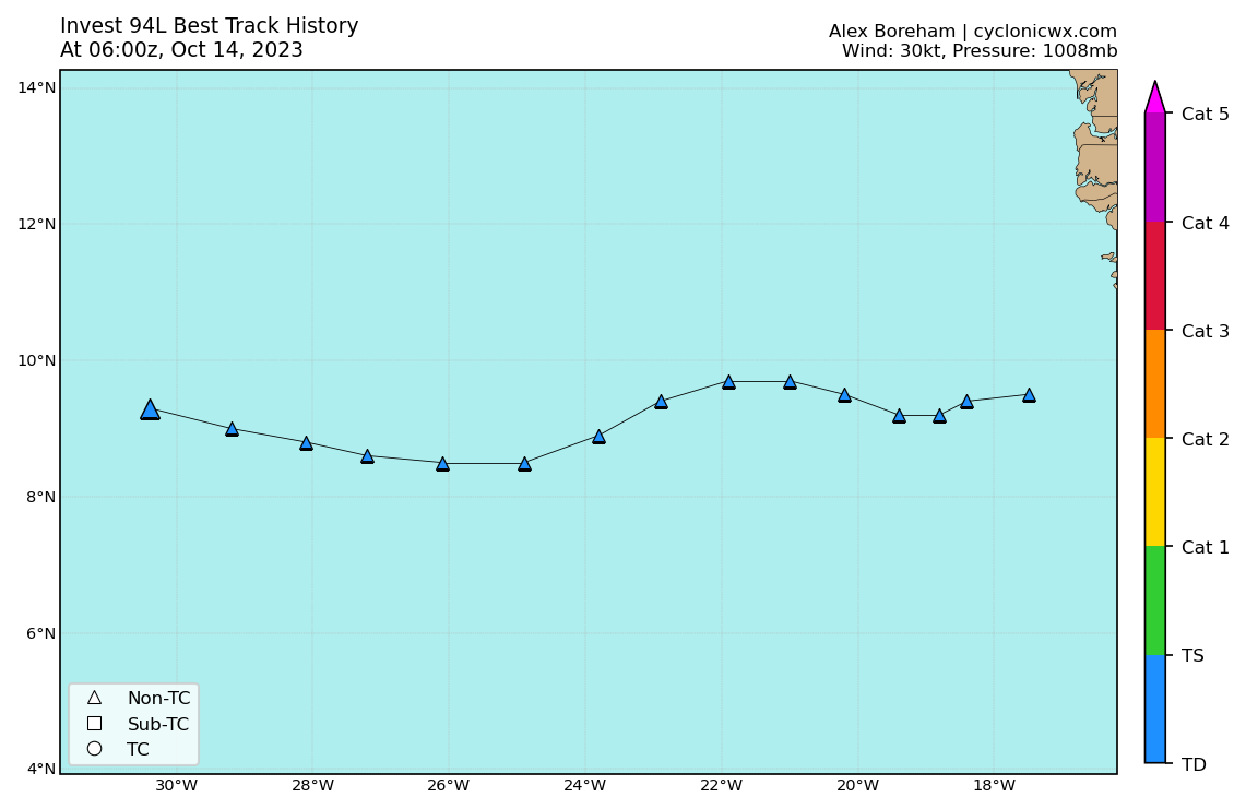
AL, 94, 2023101412, , BEST, 0, 95N, 317W, 30, 1008, LO, 34, NEQ, 0, 0, 0, 0, 1011, 150, 120, 0, 0, L, 0, , 0, 0, INVEST, S, 0, , 0, 0, 0, 0, genesis-num, 040,
1 likes
-
WeatherBoy2000
- Tropical Depression

- Posts: 93
- Joined: Mon Apr 10, 2023 9:29 am
Re: ATL: INVEST 94L - Discussion
It's looking increasingly more likely that there will be a strong to even major CV hurricane within the mdr in coming days. This is very rare for this time of year. Using NOAA's historical track tool, only a handful occurred after October 1st and mostly prior to 1900. Recent examples include Jose 1999, Tomas 2010, and Gonzalo 2014. 94l has a good chance of seeing development further east than those storms as well.
1 likes
-
cycloneye
- Admin
- Posts: 139327
- Age: 67
- Joined: Thu Oct 10, 2002 10:54 am
- Location: San Juan, Puerto Rico
Re: ATL: INVEST 94L - Discussion
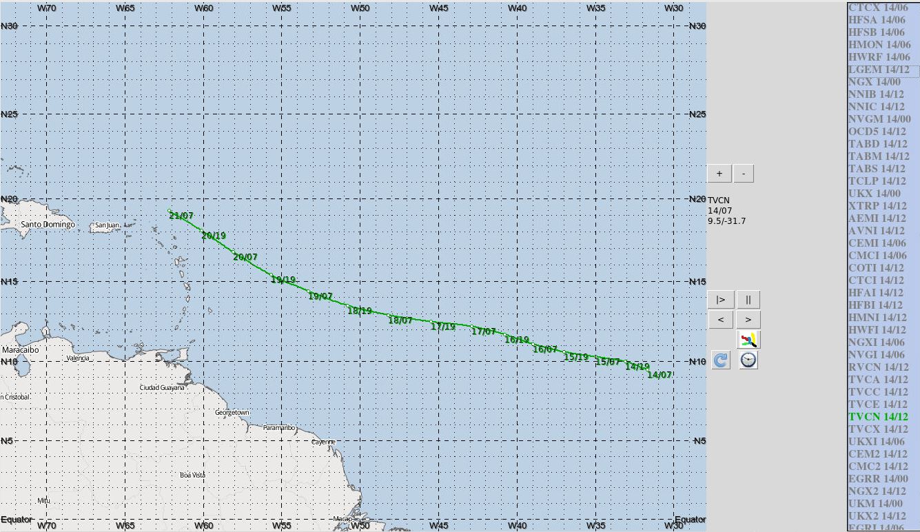
Moving at 280 degrees west at 12kt.
FORECAST TRACK FROM OFPI INITIAL HEADING/SPEED (DEG/KT):280/ 12

FORECAST TRACK FROM OFPI INITIAL HEADING/SPEED (DEG/KT):280/ 12
0 likes
Visit the Caribbean-Central America Weather Thread where you can find at first post web cams,radars
and observations from Caribbean basin members Click Here
and observations from Caribbean basin members Click Here
-
WalterWhite
- Category 1
- Posts: 311
- Joined: Fri Mar 17, 2023 5:53 pm
Re: ATL: INVEST 94L - Discussion
WeatherBoy2000 wrote:It's looking increasingly more likely that there will be a strong to even major CV hurricane within the mdr in coming days. This is very rare for this time of year. Using NOAA's historical track tool, only a handful occurred after October 1st and mostly prior to 1900. Recent examples include Jose 1999, Tomas 2010, and Gonzalo 2014. 94l has a good chance of seeing development further east than those storms as well.
Jose (1999) and Tomas (2010) were not major hurricanes. This would be an ever rarer event than your post indicates.
1 likes
-
wxman57

- Moderator-Pro Met

- Posts: 22484
- Age: 66
- Joined: Sat Jun 21, 2003 8:06 pm
- Location: Houston, TX (southwest)
Re: ATL: INVEST 94L - Discussion
Models have been over predicting MDR development all season. Only Lee managed to develop into a hurricane. Consensus takes it NE of the islands by 7am Saturday. Numbers along the track are date/CDT. I'm not very confident in track or intensity forecast.
4 likes
-
WeatherBoy2000
- Tropical Depression
- Posts: 93
- Joined: Mon Apr 10, 2023 9:29 am
Re: ATL: INVEST 94L - Discussion
WalterWhite wrote:WeatherBoy2000 wrote:It's looking increasingly more likely that there will be a strong to even major CV hurricane within the mdr in coming days. This is very rare for this time of year. Using NOAA's historical track tool, only a handful occurred after October 1st and mostly prior to 1900. Recent examples include Jose 1999, Tomas 2010, and Gonzalo 2014. 94l has a good chance of seeing development further east than those storms as well.
Jose (1999) and Tomas (2010) were not major hurricanes. This would be an ever rarer event than your post indicates.
I never said they were, but they did become hurricanes east of the Antilles, and later on strong storms of at least cat 2 intensity.
0 likes
-
cycloneye
- Admin
- Posts: 139327
- Age: 67
- Joined: Thu Oct 10, 2002 10:54 am
- Location: San Juan, Puerto Rico
Re: ATL: INVEST 94L - Discussion
Bingo. ASCAT hits partially but has a closed low and is more south than the 12z Best Track position.

6 likes
Visit the Caribbean-Central America Weather Thread where you can find at first post web cams,radars
and observations from Caribbean basin members Click Here
and observations from Caribbean basin members Click Here
-
Sciencerocks
- Category 5
- Posts: 7287
- Age: 38
- Joined: Thu Jul 06, 2017 1:51 am

Who is online
Users browsing this forum: No registered users and 20 guests