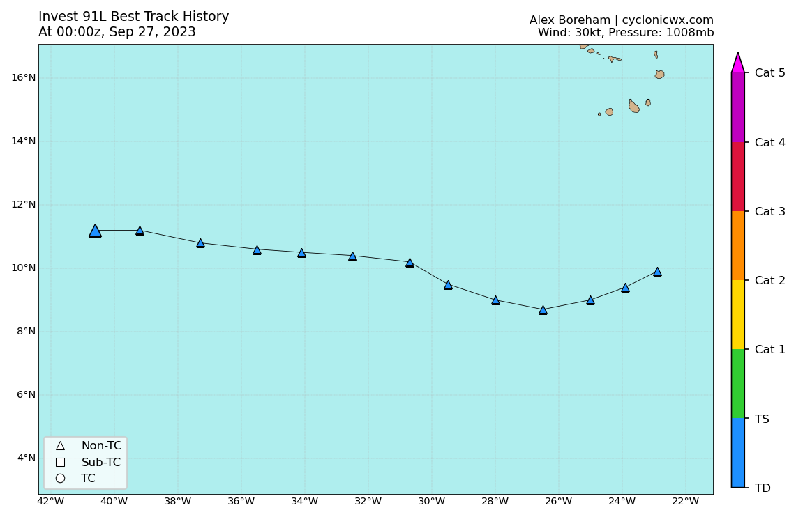
AL, 91, 2023092700, , BEST, 0, 112N, 406W, 30, 1008, LO
ATL: RINA - Remnants - Discussion
Moderator: S2k Moderators
-
cycloneye

- Admin

- Posts: 139338
- Age: 67
- Joined: Thu Oct 10, 2002 10:54 am
- Location: San Juan, Puerto Rico
Re: ATL: INVEST 91L - Discussion
1 likes
Visit the Caribbean-Central America Weather Thread where you can find at first post web cams,radars
and observations from Caribbean basin members Click Here
and observations from Caribbean basin members Click Here
-
ScottNAtlanta

- Category 5

- Posts: 2006
- Joined: Sat May 25, 2013 3:11 pm
- Location: Atlanta, GA
Re: ATL: INVEST 91L - Discussion
Most of the models had this turning NW by now. I don't see any evidence it's getting ready to make a turn more northerly. It's moving west at a pretty good clip. Looks like a center is trying to form at about 11N 43W. Both the GFS and ECMWF have this gaining some serious latitude in the next 12 hours
Last edited by ScottNAtlanta on Tue Sep 26, 2023 8:41 pm, edited 1 time in total.
1 likes
The posts in this forum are NOT official forecast and should not be used as such. They are just the opinion of the poster and may or may not be backed by sound meteorological data. They are NOT endorsed by any professional institution or storm2k.org. For official information, please refer to the NHC and NWS products.


Re: ATL: INVEST 91L - Discussion
cycloneye wrote:AL, 91, 2023092700, , BEST, 0, 112N, 406W, 30, 1008, LO
0 likes
Re: ATL: INVEST 91L - Discussion
wxman57 wrote:Models were forecasting Philippe to be a long-lasting and intense hurricane. Well, that didn't happen. Will this one have the same fate? There just isn't any high pressure to its north to move it west through the Caribbean. Season appears to be winding down. Still have to watch the NW Caribbean for any late-season Florida mischief.
Late season mischief ?
0 likes
-
Sciencerocks
- Category 5
- Posts: 7287
- Age: 38
- Joined: Thu Jul 06, 2017 1:51 am

Re: ATL: INVEST 91L - Discussion
Best Track:
Still moving west.
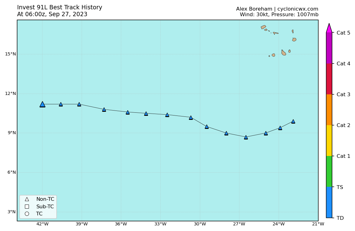
AL, 91, 2023092706, , BEST, 0, 112N, 420W, 30, 1007, LO
Still moving west.
1 likes
-
cycloneye
- Admin
- Posts: 139338
- Age: 67
- Joined: Thu Oct 10, 2002 10:54 am
- Location: San Juan, Puerto Rico
Re: ATL: INVEST 91L - Discussion
8 AM:
Central Tropical Atlantic (AL91):
Showers and thunderstorms continue to show signs of organization
in association with an area of low pressure located roughly halfway
between the Cabo Verde Islands and the Lesser Antilles.
Environmental conditions are forecast to be conducive for
development, and a tropical depression or storm is expected to form
in the next day or so while the system moves west-northwestward
across the central tropical Atlantic. Additional information on this
system, including gale warnings, can be found in High Seas Forecasts
issued by the National Weather Service.
* Formation chance through 48 hours...high...90 percent.
* Formation chance through 7 days...high...90 percent.
1 likes
Visit the Caribbean-Central America Weather Thread where you can find at first post web cams,radars
and observations from Caribbean basin members Click Here
and observations from Caribbean basin members Click Here
Re: ATL: INVEST 91L - Discussion
Best Track:
AL, 91, 2023092712, , BEST, 0, 116N, 435W, 30, 1007, LO
0 likes
-
Sciencerocks
- Category 5
- Posts: 7287
- Age: 38
- Joined: Thu Jul 06, 2017 1:51 am

-
ScottNAtlanta
- Category 5
- Posts: 2006
- Joined: Sat May 25, 2013 3:11 pm
- Location: Atlanta, GA
Re: ATL: INVEST 91L - Discussion
There is probably some interaction between 91L and Philippe. I think that models assumed a north moving Philippe would pull this with it. I think right now it is just to close to Philippe to develop and will probably follow it west
1 likes
The posts in this forum are NOT official forecast and should not be used as such. They are just the opinion of the poster and may or may not be backed by sound meteorological data. They are NOT endorsed by any professional institution or storm2k.org. For official information, please refer to the NHC and NWS products.

Re: ATL: INVEST 91L - Discussion
This sort of reminds me of 09L and Ida back in 2015. They were pretty close together for most of their life and shear shredded both of them so they never really had much of a future past being designated as a TD or TS. What I think may happen here as well.
0 likes
-
MarioProtVI
- Category 2

- Posts: 671
- Age: 22
- Joined: Sun Sep 29, 2019 7:33 pm
- Location: New Jersey
Re: ATL: INVEST 91L - Discussion
WiscoWx02 wrote:This sort of reminds me of 09L and Ida back in 2015. They were pretty close together for most of their life and shear shredded both of them so they never really had much of a future past being designated as a TD or TS. What I think may happen here as well.
Except Philippe might have a shot at hurricane intensity if it interacts more with 91L and gets pulled more south towards the favorable environment.
2 likes
Re: ATL: INVEST 91L - Discussion
2PM:
Central Tropical Atlantic (AL91):
Showers and thunderstorms have not become any better organized
in association with an area of low pressure located roughly halfway
between the Cabo Verde Islands and the Lesser Antilles.
Environmental conditions are forecast to be conducive for
development, and a tropical depression or storm is expected to form
in the next day or so while the system moves west-northwestward
across the central tropical Atlantic. Additional information on this
system, including gale warnings, can be found in High Seas Forecasts
issued by the National Weather Service.
* Formation chance through 48 hours...high...90 percent.
* Formation chance through 7 days...high...90 percent.
0 likes
-
WalterWhite

- Category 1

- Posts: 311
- Joined: Fri Mar 17, 2023 5:53 pm
Re: ATL: INVEST 91L - Discussion
Is it even still a certainty at this point that 91L becomes Rina?
1 likes
-
Sciencerocks
- Category 5
- Posts: 7287
- Age: 38
- Joined: Thu Jul 06, 2017 1:51 am

-
StormSkeptic
- Tropical Low

- Posts: 34
- Joined: Tue Sep 30, 2003 8:40 pm
- Location: New Jersey
Re: ATL: INVEST 91L - Discussion
WalterWhite wrote:Is it even still a certainty at this point that 91L becomes Rina?
Think a fair question. The models want to develop it, at least someswhat, but not impressed with how it looks at the moment. Also, think it depends on whether Philippe really fades away.
1 likes
-
cycloneye
- Admin
- Posts: 139338
- Age: 67
- Joined: Thu Oct 10, 2002 10:54 am
- Location: San Juan, Puerto Rico
Re: ATL: INVEST 91L - Discussion
8 PM.
Central Tropical Atlantic (AL91):
Showers and thunderstorms have become a little more concentrated
with an area of low pressure located roughly halfway between the
Cabo Verde Islands and the Lesser Antilles. Environmental conditions
are forecast to be conducive for development, as long as this system
remains far enough removed from Tropical Storm Philippe to its west.
A tropical depression or storm is expected to form in the next day
or so while the system moves northwestward across the central
tropical Atlantic. Additional information on this system, including
gale warnings, can be found in High Seas Forecasts issued by the
National Weather Service.
* Formation chance through 48 hours...high...90 percent.
* Formation chance through 7 days...high...90 percent.
0 likes
Visit the Caribbean-Central America Weather Thread where you can find at first post web cams,radars
and observations from Caribbean basin members Click Here
and observations from Caribbean basin members Click Here
-
cycloneye
- Admin
- Posts: 139338
- Age: 67
- Joined: Thu Oct 10, 2002 10:54 am
- Location: San Juan, Puerto Rico
Re: ATL: INVEST 91L - Discussion
Looks better tonight. As long it not gets close to Philippe, it has a good chance to develop.

0 likes
Visit the Caribbean-Central America Weather Thread where you can find at first post web cams,radars
and observations from Caribbean basin members Click Here
and observations from Caribbean basin members Click Here
-
cycloneye
- Admin
- Posts: 139338
- Age: 67
- Joined: Thu Oct 10, 2002 10:54 am
- Location: San Juan, Puerto Rico
Re: ATL: INVEST 91L - Discussion
First dvorak update.
A. TROPICAL DISTURBANCE (91L)
B. 28/0000Z
C. 14.1N
D. 44.1W
E. FIVE/GOES-E
F. T1.5/1.5
G. IR/EIR/SWIR
H. REMARKS...3/10 BANDING RESULTS IN A DT OF 1.5. 2118Z SSMIS PASS SHOWED
A DEFINED LLCC. ROBUST OUTER CONVECTIVE BAND NE-E-SE QUADS. SYSTEM APPEARS
TO BE REMAINING DISCRETE FM 17L. MET=1.0 AND PT=1.5. FT BASED ON DT.
I. ADDL POSITIONS
NIL
...KONON
0 likes
Visit the Caribbean-Central America Weather Thread where you can find at first post web cams,radars
and observations from Caribbean basin members Click Here
and observations from Caribbean basin members Click Here
Who is online
Users browsing this forum: No registered users and 4 guests