ATL: TAMMY - Post-Tropical - Discussion
Moderator: S2k Moderators

ATL: INVEST 94L - Models
the relatively safe recurve pattern away from land continues it seems.......wow what persistence and good fortune! 
0 likes
-
cheezyWXguy

- Category 5

- Posts: 5556
- Joined: Mon Feb 13, 2006 12:29 am
- Location: Dallas, TX
Re: ATL: INVEST 94L - Models
mantis83 wrote:the relatively safe recurve pattern away from land continues it seems.......wow what persistence and good fortune!
Can’t really say this til it passes the islands. Circulation center was found further south than best track indicates, which has a chance of altering track to some degree. Also several eps members still showing a hit. We shouldn’t be inviting people to let their guard down.
9 likes
-
cycloneye

- Admin

- Posts: 139327
- Age: 67
- Joined: Thu Oct 10, 2002 10:54 am
- Location: San Juan, Puerto Rico
Re: ATL: INVEST 94L - Discussion
5 likes
Visit the Caribbean-Central America Weather Thread where you can find at first post web cams,radars
and observations from Caribbean basin members Click Here
and observations from Caribbean basin members Click Here
-
WeatherBoy2000
- Tropical Depression

- Posts: 93
- Joined: Mon Apr 10, 2023 9:29 am
Re: ATL: INVEST 94L - Discussion
Really wild for mid October, at this rate we'll be having mdr invests into November. Luckily, most of the mdr stuff has been weak and/or recurved early on, hopefully this is the case here for the islands.
3 likes
-
Category5Kaiju

- Category 5
- Posts: 3402
- Age: 22
- Joined: Thu Dec 24, 2020 12:45 pm
- Location: Seattle
Re: ATL: INVEST 94L - Models
mantis83 wrote:the relatively safe recurve pattern away from land continues it seems.......wow what persistence and good fortune!
Don't jinx it
Because what if this new system ends up being an exception? Have to be prepared in the event like that at all times!
1 likes
Unless explicitly stated, all information covered in my posts is based on my opinions and observations. Please refer to a professional meteorologist or an accredited weather research agency otherwise, especially if serious decisions must be made in the event of a potentially life-threatening tropical storm or hurricane.
-
cycloneye
- Admin
- Posts: 139327
- Age: 67
- Joined: Thu Oct 10, 2002 10:54 am
- Location: San Juan, Puerto Rico
Re: ATL: INVEST 94L - Discussion
Eastern Tropical Atlantic (AL94):
Showers and thunderstorms associated with an area of low pressure
located several hundred miles southwest of the Cabo Verde Islands
have not become any better organized this afternoon. Environmental
conditions are becoming more conducive for further development, and
a tropical depression or tropical storm is likely to form within the
next couple of days while the system moves westward or
west-northwestward across the central and western tropical Atlantic.
Additional information on this system, including gale warnings, can
be found in High Seas Forecasts issued by the National Weather
Service.
* Formation chance through 48 hours...high...70 percent.
* Formation chance through 7 days...high...90 percent.
1 likes
Visit the Caribbean-Central America Weather Thread where you can find at first post web cams,radars
and observations from Caribbean basin members Click Here
and observations from Caribbean basin members Click Here
-
HurricaneRyan
- Category 2

- Posts: 712
- Age: 30
- Joined: Sun Dec 05, 2010 3:05 pm
Re: ATL: INVEST 94L - Models
Category5Kaiju wrote:mantis83 wrote:the relatively safe recurve pattern away from land continues it seems.......wow what persistence and good fortune!
Don't jinx it
Because what if this new system ends up being an exception? Have to be prepared in the event like that at all times!
This. Especially because the next name on the list is Tammy. I had a half-sister with that name and she wasn't exactly nice. If I had to pick between which names on the list left sounded the nastiest, Tammy sounds the worst.
1 likes
Kay '22 Hilary '23
-
WalterWhite

- Category 1

- Posts: 311
- Joined: Fri Mar 17, 2023 5:53 pm
Re: ATL: INVEST 94L - Discussion
cycloneye wrote:Bingo. ASCAT hits partially but has a closed low and is more south than the 12z Best Track position.
https://i.imgur.com/pVOU0NT.png
Why has the NHC not classified this a tropical cyclone yet?
1 likes
-
cycloneye
- Admin
- Posts: 139327
- Age: 67
- Joined: Thu Oct 10, 2002 10:54 am
- Location: San Juan, Puerto Rico
Re: ATL: INVEST 94L - Discussion
No TD at 18z Best Track.

AL, 94, 2023101418, , BEST, 0, 94N, 318W, 30, 1008, LO
1 likes
Visit the Caribbean-Central America Weather Thread where you can find at first post web cams,radars
and observations from Caribbean basin members Click Here
and observations from Caribbean basin members Click Here

Re: ATL: INVEST 94L - Discussion
WalterWhite wrote:cycloneye wrote:Bingo. ASCAT hits partially but has a closed low and is more south than the 12z Best Track position.
https://i.imgur.com/pVOU0NT.png
Why has the NHC not classified this a tropical cyclone yet?
Convection is quite anemic today despite the closed circulation. If we get some convective activity later tonight, the NHC may finally pull the trigger.
4 likes
Irene '11 Sandy '12 Hermine '16 5/15/2018 Derecho Fay '20 Isaias '20 Elsa '21 Henri '21 Ida '21
I am only a meteorology enthusiast who knows a decent amount about tropical cyclones. Look to the professional mets, the NHC, or your local weather office for the best information.
I am only a meteorology enthusiast who knows a decent amount about tropical cyclones. Look to the professional mets, the NHC, or your local weather office for the best information.
Re: ATL: INVEST 94L - Discussion
And it will be a T storm during what may end up being a strong El Nino year. Really quite amazing if not even unprecedented in the era of records? After a few slow(ish) years 2013-2015, we have really seen increased activity in the Atlantic since 2017 relative to the post 1995 background state.
6 likes
All posts by Dean_175 are NOT official forecasts and should not be used as such. They are just the opinion of the poster and may or may not be backed by sound meteorological data. They are NOT endorsed by any professional institution or storm2k.org. For official information, please refer to the NHC and NWS products.

Re: ATL: INVEST 94L - Discussion
aspen wrote:WalterWhite wrote:cycloneye wrote:Bingo. ASCAT hits partially but has a closed low and is more south than the 12z Best Track position.
https://i.imgur.com/pVOU0NT.png
Why has the NHC not classified this a tropical cyclone yet?
Convection is quite anemic today despite the closed circulation. If we get some convective activity later tonight, the NHC may finally pull the trigger.
The weak and west track is bad for the island forecast with ridging north of the track.
The models are pulling this north only after it reaches Tropical storm or hurricane strength where the steering would be different.
3 likes
-
cycloneye
- Admin
- Posts: 139327
- Age: 67
- Joined: Thu Oct 10, 2002 10:54 am
- Location: San Juan, Puerto Rico
Re: ATL: INVEST 94L - Discussion
8 PM:
Eastern Tropical Atlantic (AL94):
Showers and thunderstorms associated with an area of low pressure
located several hundred miles southwest of the Cabo Verde Islands
have become less organized since this morning. However,
environmental conditions are forecast to become more conducive for
development, and a tropical depression or tropical storm is likely
to form within the next couple of days while the system moves
westward or west-northwestward across the central and western
tropical Atlantic. Additional information on this system, including
gale warnings, can be found in High Seas Forecasts issued by the
National Weather Service.
* Formation chance through 48 hours...high...70 percent.
* Formation chance through 7 days...high...90 percent.
0 likes
Visit the Caribbean-Central America Weather Thread where you can find at first post web cams,radars
and observations from Caribbean basin members Click Here
and observations from Caribbean basin members Click Here
-
MEANINGLESS_NUMBERS
- Tropical Depression
- Posts: 61
- Joined: Mon Nov 02, 2020 1:43 pm
Re: ATL: INVEST 94L - Models
mantis83 wrote:the relatively safe recurve pattern away from land continues it seems.......wow what persistence and good fortune!
Those “recurve” tracks are over Bermuda.
0 likes
-
cycloneye
- Admin
- Posts: 139327
- Age: 67
- Joined: Thu Oct 10, 2002 10:54 am
- Location: San Juan, Puerto Rico
Re: ATL: INVEST 94L - Discussion
Interesting that the winds are down from 30kt to 25kt.
AL, 94, 2023101500, , BEST, 0, 95N, 325W, 25, 1009, LO
2 likes
Visit the Caribbean-Central America Weather Thread where you can find at first post web cams,radars
and observations from Caribbean basin members Click Here
and observations from Caribbean basin members Click Here
-
cycloneye
- Admin
- Posts: 139327
- Age: 67
- Joined: Thu Oct 10, 2002 10:54 am
- Location: San Juan, Puerto Rico
Re: ATL: INVEST 94L - Discussion
A. TROPICAL DISTURBANCE (94L)
B. 15/0000Z
C. 9.5N
D. 33.2W
E. FIVE/MET-10
F. T1.5/1.5
G. IR/EIR/SWIR
H. REMARKS...3/10 BANDING SUGGESTS A DT=1.5. THE MET AND PT AGREE. THE
FT IS BASED ON THE MET SINCE A DISCRETE LLCC COULD NOT BE LOCATED AND
MAY BE OBSCURED BY EITHER OF TWO FLARE-UPS OF CONVECTION ASSOCIATED WITH
THE SYSTEM.
I. ADDL POSITIONS
NIL
1 likes
Visit the Caribbean-Central America Weather Thread where you can find at first post web cams,radars
and observations from Caribbean basin members Click Here
and observations from Caribbean basin members Click Here
-
Sciencerocks
- Category 5
- Posts: 7287
- Age: 38
- Joined: Thu Jul 06, 2017 1:51 am

Re: ATL: INVEST 94L - Discussion
Small recent hot tower just south of 10N probably locates the center between the two larger areas of convection.
Shear keeping these systems weak but look at that narrow tropical ridge circulation rolling east over PR in the WV.
Shear keeping these systems weak but look at that narrow tropical ridge circulation rolling east over PR in the WV.
0 likes


Re: ATL: INVEST 94L - Discussion
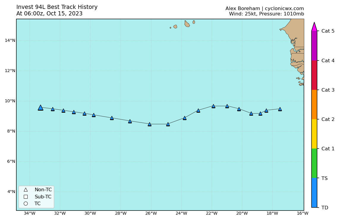
abajan wrote:AL, 94, 2023101506, , BEST, 0, 96N, 333W, 25, 1010, LO
https://images2.imgbox.com/15/42/xYvdH1IU_o.png
Models downtrending, bust, dry air next
1 likes
blonde stacey (xe/xem/xir)
Who is online
Users browsing this forum: No registered users and 16 guests