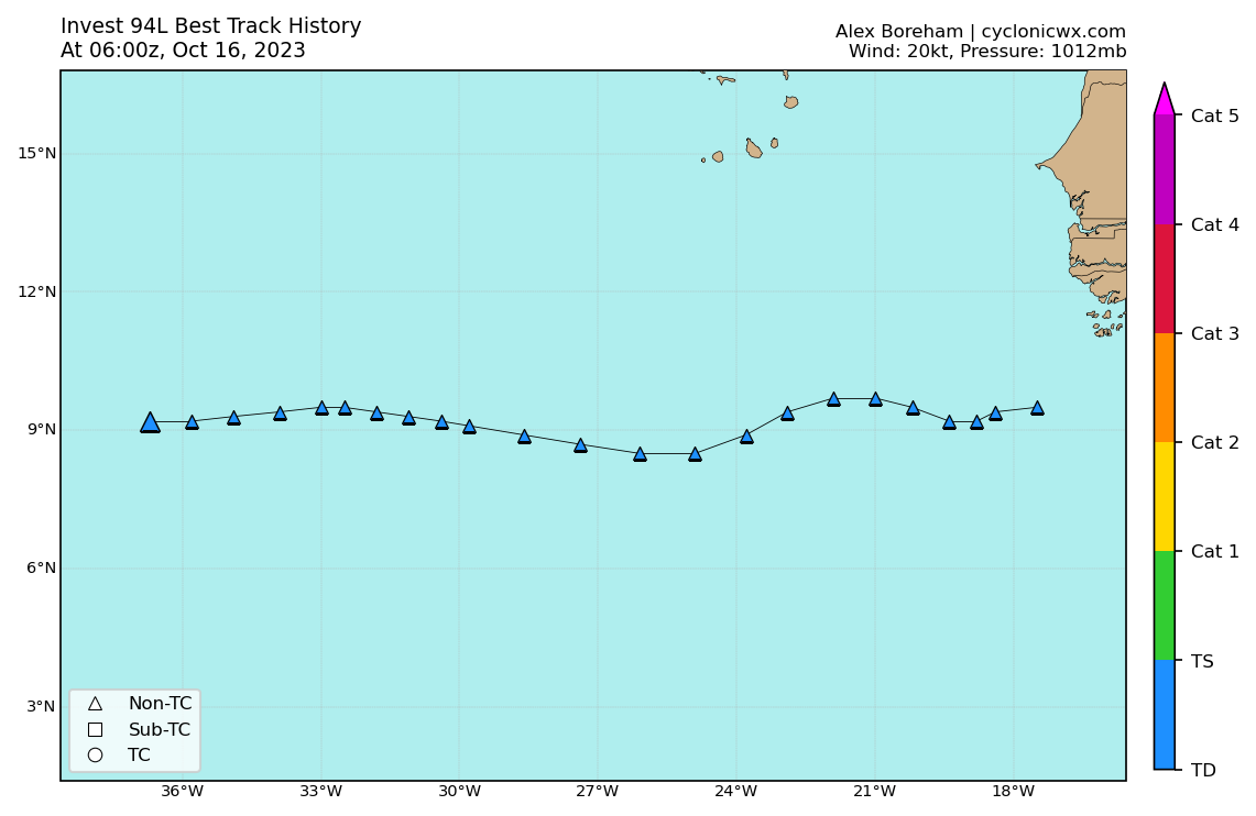
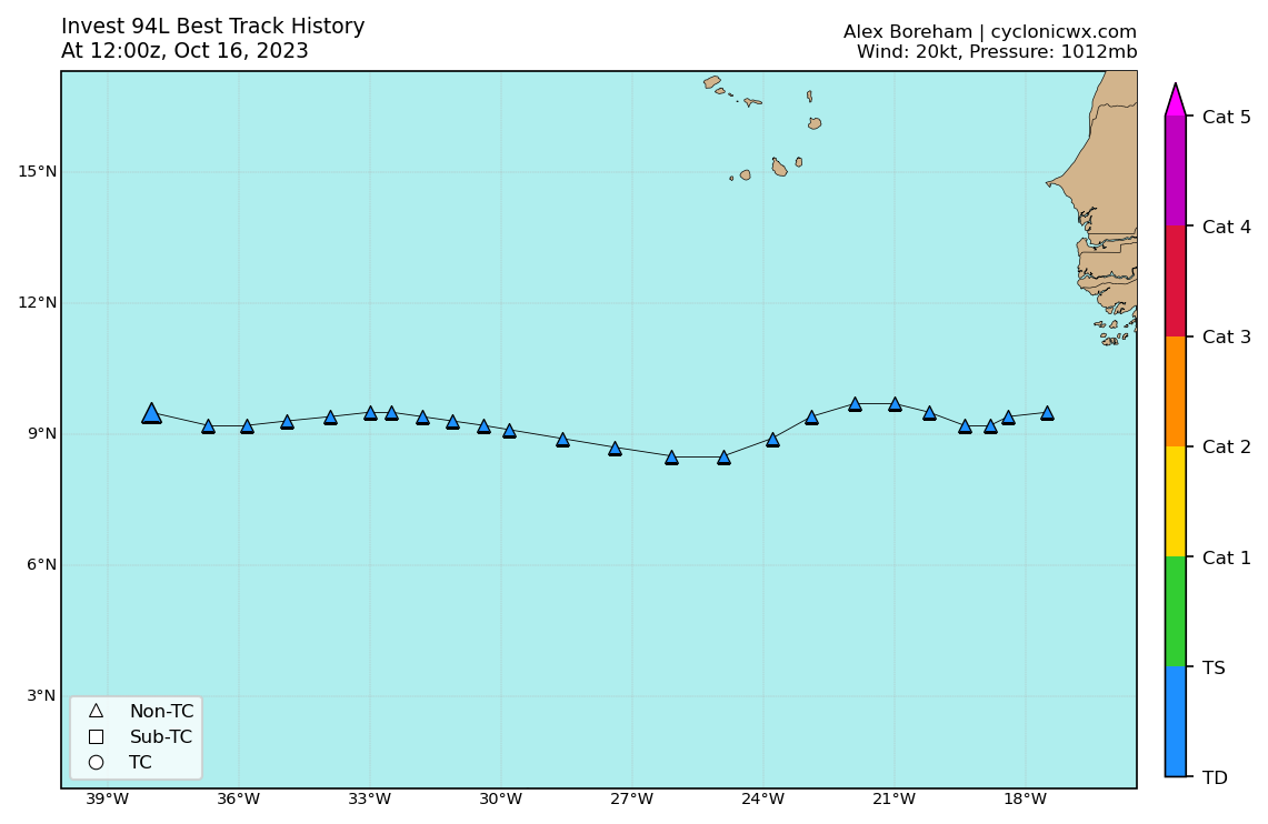
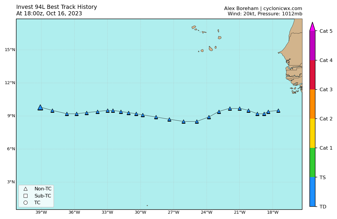
ATL: TAMMY - Post-Tropical - Discussion

Moderator: S2k Moderators

Message
Author
al78
Professional-Met
Professional-Met
Posts: 249
Joined: Thu Nov 01, 2018 12:20 pm

Re: ATL: INVEST 94L - Discussion

#81 Postby al78 » Sun Oct 15, 2023 4:05 am

Dean_175 wrote:


And it will be a T storm during what may end up being a strong El Nino year. Really quite amazing if not even unprecedented in the era of records? After a few slow(ish) years 2013-2015, we have really seen increased activity in the Atlantic since 2017 relative to the post 1995 background state.


After the quiet years of 2013-2015 I recall some people were asking whether the multi-decadal active phase had ended, illustrating one needs to be cautious about reacting to the here and now.
0 likes   

User avatar
cycloneye
Admin
Admin
Posts: 139327
Age: 67
Joined: Thu Oct 10, 2002 10:54 am
Location: San Juan, Puerto Rico

Re: ATL: INVEST 94L - Discussion

#82 Postby cycloneye » Sun Oct 15, 2023 6:58 am

8 AM:

Central Tropical Atlantic (AL94):
A broad area of low pressure located several hundred miles
southwest of the Cabo Verde Islands is producing disorganized
showers and thunderstorms. While this system has become less
organized since yesterday, the overall environmental conditions are
forecast to become more conducive for development, and a tropical
depression or tropical storm is still likely to form within the
next few days while the system moves westward or west-northwestward
across the central and western tropical Atlantic. Additional
information on this system, including gale warnings, can be found in
High Seas Forecasts issued by the National Weather Service.
* Formation chance through 48 hours...medium...60 percent.
* Formation chance through 7 days...high...90 percent.
1 likes   
Visit the Caribbean-Central America Weather Thread where you can find at first post web cams,radars
and observations from Caribbean basin members Click Here

User avatar
cycloneye
Admin
Admin
Posts: 139327
Age: 67
Joined: Thu Oct 10, 2002 10:54 am
Location: San Juan, Puerto Rico

Re: ATL: INVEST 94L - Discussion

#83 Postby cycloneye » Sun Oct 15, 2023 7:58 am

Pressure is up to 1011 mbs and winds are down to 20kt.

AL, 94, 2023101512, , BEST, 0, 98N, 347W, 20, 1011, LO


Image
2 likes   
Visit the Caribbean-Central America Weather Thread where you can find at first post web cams,radars
and observations from Caribbean basin members Click Here

User avatar
WiscoWx02
Category 1
Category 1
Posts: 341
Age: 21
Joined: Sat Jul 31, 2021 8:09 pm
Location: Minnesota

Re: ATL: INVEST 94L - Discussion

#84 Postby WiscoWx02 » Sun Oct 15, 2023 9:07 am

DioBrando wrote:
abajan wrote:
AL, 94, 2023101506, , BEST, 0, 96N, 333W, 25, 1010, LO


https://images2.imgbox.com/15/42/xYvdH1IU_o.png

Models downtrending, bust, dry air next


Yeah I have to agree to be honest. Climatology is a hard thing to overcome too. Models have been way over doing hurricane intensification since Imelda and I think this could very well be another case here. Even Derek Ort seems to be backing off on this one. I think it could still develop but the odds of it becoming a hurricane are thinning out fast imo.
2 likes   

User avatar
Hurricane2022
Category 4
Category 4
Posts: 945
Joined: Tue Aug 23, 2022 11:38 pm
Location: Araçatuba, Brazil

Re: ATL: INVEST 94L - Discussion

#85 Postby Hurricane2022 » Sun Oct 15, 2023 11:29 am

If 94L becomes nothing in this region, what will be its future?
- Will it go to the Central Caribbean and become a threat to the United States/Mexico/Cuba?
- Will it dissipate somewhere once and for all?
- Or will it go to the East Pacific and become a tropical cyclone there?
1 likes   
Sorry for the bad English sometimes...!
For reliable and detailed information for any meteorological phenomenon, please consult the National Hurricane Center, Joint Typhoon Warning Center , or your local Meteo Center.

--------

Una cvm Christo, pro Christo, et in Christo. Sit nomen Domini benedictvm.

User avatar
abajan
S2K Supporter
S2K Supporter
Posts: 4175
Joined: Sun Sep 07, 2003 5:10 am
Location: Barbados

Re: ATL: INVEST 94L - Discussion

#86 Postby abajan » Sun Oct 15, 2023 12:31 pm

2PM:
A broad area of low pressure located several hundred miles southwest
of the Cabo Verde Islands is producing some showers and
thunderstorms. While this system is less organized since yesterday,
the overall environmental conditions are forecast to become more
conducive for development, and a tropical depression is still likely
to form around midweek while the system moves westward or
west-northwestward across the central and western tropical Atlantic.
* Formation chance through 48 hours...medium...40 percent.
* Formation chance through 7 days...high...80 percent.
1 likes   

User avatar
DioBrando
Category 4
Category 4
Posts: 917
Age: 27
Joined: Sun Aug 12, 2018 12:45 pm

Re: ATL: INVEST 94L - Discussion

#87 Postby DioBrando » Sun Oct 15, 2023 1:31 pm

WiscoWx02 wrote:
DioBrando wrote:
abajan wrote:
AL, 94, 2023101506, , BEST, 0, 96N, 333W, 25, 1010, LO


https://images2.imgbox.com/15/42/xYvdH1IU_o.png

Models downtrending, bust, dry air next


Yeah I have to agree to be honest. Climatology is a hard thing to overcome too. Models have been way over doing hurricane intensification since Imelda and I think this could very well be another case here. Even Derek Ort seems to be backing off on this one. I think it could still develop but the odds of it becoming a hurricane are thinning out fast imo.


Climatology wins. this prob won't form as it's looking even worse now.
0 likes   
blonde stacey (xe/xem/xir)

User avatar
cycloneye
Admin
Admin
Posts: 139327
Age: 67
Joined: Thu Oct 10, 2002 10:54 am
Location: San Juan, Puerto Rico

Re: ATL: INVEST 94L - Discussion

#88 Postby cycloneye » Sun Oct 15, 2023 1:55 pm

abajan They fixed the Best Track file.

AL, 94, 2023101418, , BEST, 0, 94N, 318W, 30, 1008, LO, 0, , 0, 0, 0, 0, 1011, 150, 120, 40, 0, L, 0, , 0, 0, INVEST, S, 0, , 0, 0, 0, 0, genesis-num, 040,
AL, 94, 2023101500, , BEST, 0, 95N, 325W, 25, 1009, LO, 0, , 0, 0, 0, 0, 1011, 150, 120, 35, 0, L, 0, , 0, 0, INVEST, S, 0, , 0, 0, 0, 0, genesis-num, 040,
AL, 94, 2023101506, , BEST, 0, 95N, 329W, 25, 1010, LO, 0, , 0, 0, 0, 0, 1012, 150, 120, 35, 0, L, 0, , 0, 0, INVEST, S, 0, , 0, 0, 0, 0, genesis-num, 040,
AL, 94, 2023101512, , BEST, 0, 95N, 335W, 20, 1011, LO, 0, , 0, 0, 0, 0, 1012, 150, 120, 30, 0, L, 0, , 0, 0, INVEST, S, 0, , 0, 0, 0, 0, genesis-num, 040,
AL, 94, 2023101518, , BEST, 0, 95N, 340W, 20, 1011, LO


Image
1 likes   
Visit the Caribbean-Central America Weather Thread where you can find at first post web cams,radars
and observations from Caribbean basin members Click Here

User avatar
cycloneye
Admin
Admin
Posts: 139327
Age: 67
Joined: Thu Oct 10, 2002 10:54 am
Location: San Juan, Puerto Rico

Re: ATL: INVEST 94L - Discussion

#89 Postby cycloneye » Sun Oct 15, 2023 6:45 pm

8 PM:

Central Tropical Atlantic (AL94):
A broad area of low pressure located over the central tropical
Atlantic is producing some shower and thunderstorm activity.
Although the environment may not support much development during
the next couple of days, conditions are expected to become more
conducive thereafter, and a tropical depression is still likely to
form mid to late week while moving westward or west-northwestward
across the central and western tropical Atlantic.
* Formation chance through 48 hours...low...30 percent.
* Formation chance through 7 days...high...70 percent.
0 likes   
Visit the Caribbean-Central America Weather Thread where you can find at first post web cams,radars
and observations from Caribbean basin members Click Here

User avatar
ElectricStorm
Category 5
Category 5
Posts: 4597
Age: 23
Joined: Tue Aug 13, 2019 11:23 pm
Location: Skiatook, OK / Norman, OK

ATL: INVEST 94L - Models

#90 Postby ElectricStorm » Sun Oct 15, 2023 6:52 pm

I think there could be a somewhat brief window it can possibly develop still but I doubt it gets strong. Perhaps a 45kt TS or so, but that's probably about it.
0 likes   
I am in no way a professional. Take what I say with a grain of salt as I could be totally wrong. Please refer to the NHC, NWS, or SPC for official information.

Boomer Sooner!

User avatar
cycloneye
Admin
Admin
Posts: 139327
Age: 67
Joined: Thu Oct 10, 2002 10:54 am
Location: San Juan, Puerto Rico

Re: ATL: INVEST 94L - Discussion

#91 Postby cycloneye » Sun Oct 15, 2023 7:38 pm

A. TROPICAL DISTURBANCE (94L)

B. 16/0000Z

C. 10.5N

D. 37.2W

E. FIVE/GOES-E

F. TOO WEAK

G. IR/EIR/SWIR

H. REMARKS...THIS SYSTEM IS TOO WEAK TO CLASSIFY DUE TO CONVECTION
WITH <2/10 BANDING AND LACK OF CERTAINTY IN THE PRESENCE OF A CLOSED
CIRCULATION. THIS WILL BE THE FINAL BULLETIN UNLESS THE SYSTEM
RESTRENGTHENS AND REORGANIZES ENOUGH TO BE CLASSIFIABLE.

I. ADDL POSITIONS

NIL


...CLARK
0 likes   
Visit the Caribbean-Central America Weather Thread where you can find at first post web cams,radars
and observations from Caribbean basin members Click Here

User avatar
cycloneye
Admin
Admin
Posts: 139327
Age: 67
Joined: Thu Oct 10, 2002 10:54 am
Location: San Juan, Puerto Rico

Re: ATL: INVEST 94L - Discussion

#92 Postby cycloneye » Sun Oct 15, 2023 7:58 pm

AL, 94, 2023101600, , BEST, 0, 92N, 358W, 20, 1012, LO


Image
1 likes   
Visit the Caribbean-Central America Weather Thread where you can find at first post web cams,radars
and observations from Caribbean basin members Click Here

User avatar
abajan
S2K Supporter
S2K Supporter
Posts: 4175
Joined: Sun Sep 07, 2003 5:10 am
Location: Barbados

Re: ATL: INVEST 94L - Discussion

#93 Postby abajan » Mon Oct 16, 2023 4:08 am

AL, 94, 2023101606, , BEST, 0, 92N, 367W, 20, 1012, LO


Image
0 likes   

User avatar
Hurricane2022
Category 4
Category 4
Posts: 945
Joined: Tue Aug 23, 2022 11:38 pm
Location: Araçatuba, Brazil

Re: ATL: INVEST 94L - Discussion

#94 Postby Hurricane2022 » Mon Oct 16, 2023 4:31 am

Another bust, but I think we can also consider that this was (another) collective delusion of the forecast models, since 94L simply obeyed the climatology and is succumbing in the midst of unfavorable conditions for a TCG in the MDR.
1 likes   
Sorry for the bad English sometimes...!
For reliable and detailed information for any meteorological phenomenon, please consult the National Hurricane Center, Joint Typhoon Warning Center , or your local Meteo Center.

--------

Una cvm Christo, pro Christo, et in Christo. Sit nomen Domini benedictvm.

User avatar
abajan
S2K Supporter
S2K Supporter
Posts: 4175
Joined: Sun Sep 07, 2003 5:10 am
Location: Barbados

Re: ATL: INVEST 94L - Discussion

#95 Postby abajan » Mon Oct 16, 2023 6:49 am

8AM:
A broad area of low pressure located over the central tropical
Atlantic about midway between the Windward Islands and western
Africa is producing disorganized shower activity. The low-level
circulation has become better defined since yesterday and, since
environmental conditions are expected to remain conducive for
further development, a tropical depression is still likely to form
within a few days. This system is forecast to move westward or
west-northwestward across the central and western tropical Atlantic
during the next several days.
* Formation chance through 48 hours...low...30 percent.
* Formation chance through 7 days...high...70 percent.
0 likes   

User avatar
abajan
S2K Supporter
S2K Supporter
Posts: 4175
Joined: Sun Sep 07, 2003 5:10 am
Location: Barbados

Re: ATL: INVEST 94L - Discussion

#96 Postby abajan » Mon Oct 16, 2023 7:56 am

AL, 94, 2023101612, , BEST, 0, 95N, 380W, 20, 1012, LO


Image

Image
0 likes   

User avatar
Teban54
Category 5
Category 5
Posts: 1974
Joined: Sat May 19, 2018 1:19 pm

Re: ATL: INVEST 94L - Discussion

#97 Postby Teban54 » Mon Oct 16, 2023 11:00 am

Is 2 days near the record for the expectations to shift from "30+ ACE major threatening the islands with 900 mb ensemble members" to "may not even develop"?
10 likes   

User avatar
aspen
Category 5
Category 5
Posts: 8057
Joined: Sat Oct 12, 2019 7:10 pm
Location: Connecticut, USA

Re: ATL: INVEST 94L - Discussion

#98 Postby aspen » Mon Oct 16, 2023 11:48 am

Just a few days ago this looked like it was so close to becoming a TC…then poof. Looks like El Niño won this round against the hyper-warm MDR. If this was a -ENSO year with such an active and warm MDR, this probably would’ve developed.
3 likes   
Irene '11 Sandy '12 Hermine '16 5/15/2018 Derecho Fay '20 Isaias '20 Elsa '21 Henri '21 Ida '21

I am only a meteorology enthusiast who knows a decent amount about tropical cyclones. Look to the professional mets, the NHC, or your local weather office for the best information.

User avatar
cycloneye
Admin
Admin
Posts: 139327
Age: 67
Joined: Thu Oct 10, 2002 10:54 am
Location: San Juan, Puerto Rico

Re: ATL: INVEST 94L - Discussion

#99 Postby cycloneye » Mon Oct 16, 2023 1:32 pm

Tropical Weather Outlook
NWS National Hurricane Center Miami FL
200 PM EDT Mon Oct 16 2023

For the North Atlantic...Caribbean Sea and the Gulf of Mexico:

1. Central Tropical Atlantic (AL94):
A broad area of low pressure located over the central tropical
Atlantic about midway between the Windward Islands and western
Africa is producing a large area of disorganized showers and
thunderstorms. Satellite data indicate that the low-level
circulation continues to become better defined and, since
environmental conditions are expected to remain conducive for
further development, a tropical depression is likely to form within
a few days. This system is forecast to move westward to
west-northwestward across the central and western tropical Atlantic
during the next several days.
* Formation chance through 48 hours...medium...40 percent.
* Formation chance through 7 days...high...80 percent.

Forecaster Blake
2 likes   
Visit the Caribbean-Central America Weather Thread where you can find at first post web cams,radars
and observations from Caribbean basin members Click Here

User avatar
abajan
S2K Supporter
S2K Supporter
Posts: 4175
Joined: Sun Sep 07, 2003 5:10 am
Location: Barbados

Re: ATL: INVEST 94L - Discussion

#100 Postby abajan » Mon Oct 16, 2023 3:12 pm

AL, 94, 2023101618, , BEST, 0, 98N, 391W, 20, 1012, LO


Image

Image
2 likes   


Return to “2023”

Who is online

Users browsing this forum: No registered users and 13 guests