Banda Sea: Invest 90P - TCFA Canceled

Moderator: S2k Moderators

Message
Author
User avatar
HURAKAN
Professional-Met
Professional-Met
Posts: 46086
Age: 37
Joined: Thu May 20, 2004 4:34 pm
Location: Key West, FL
Contact:

Banda Sea: Invest 90P - TCFA Canceled

#1 Postby HURAKAN » Sat Mar 28, 2009 10:21 pm

29/0230 UTC 8.2S 129.5E T1.5/1.5 90P -- Southeast Indian

Floater: http://www.ssd.noaa.gov/PS/TROP/mtsatfloat1.html

Image

Image
0 likes   

User avatar
HURAKAN
Professional-Met
Professional-Met
Posts: 46086
Age: 37
Joined: Thu May 20, 2004 4:34 pm
Location: Key West, FL
Contact:

#2 Postby HURAKAN » Sat Mar 28, 2009 10:22 pm

Australian Government Bureau of Meteorology
Northern Territory
Darwin Regional Forecasting Centre

40:2:1:24:08S129E999:11:00
SECURITE

HIGH SEAS WEATHER WARNING

HIGH SEAS WEATHER WARNING FOR METAREA 10/11
Issued by the AUSTRALIAN BUREAU OF METEOROLOGY, DARWIN
Issued at 0149 UTC 29 MARCH 2009

PLEASE BE AWARE
Wind gusts can be a further 40 percent stronger than the averages given here,
and maximum waves may be up to twice the height.

GALE WARNING FOR NORTHERN AREA

SITUATION
At 0000 UTC a Tropical Low was centred within 50 nautical miles of
latitude eight decimal zero south [8.0S]
longitude one hundred and twenty nine decimal two east [129.2E]
Recent movement : near stationary
Maximum winds : 25 knots
Central pressure: 1004 hPa
The low may develop into a tropical cyclone in the next 18 to 24 hours.

AREA AFFECTED
Within 60 nautical miles of the centre.

FORECAST
Clockwise winds 20/25 knots may increase to 30/40 knots from 1800 UTC 29 March,
with rough to very rough seas and moderate swell.

Forecast positions
At 1200 UTC 29 March: Within 80 nautical miles of 8.1 south 128.9 east
Central pressure 1002 hPa.
Winds to 30 knots.
At 0000 UTC 30 March: Within 110 nautical miles of 8.2 south 127.6 east
Central pressure 998 hPa.
Winds to 40 knots.

REMARKS
All ships in the area please send weather reports every three hours.
Regular weather observing ships use normal channels.
Other ships please use either email to nttcwc@bom.gov.au or fax to +6189203829
or satellite to SAC 1241 through Land Earth Station Perth 212.

Next warning will be issued by 0730 UTC 29 March 2009.

DARWIN Tropical Cyclone Warning Centre
0 likes   

User avatar
HURAKAN
Professional-Met
Professional-Met
Posts: 46086
Age: 37
Joined: Thu May 20, 2004 4:34 pm
Location: Key West, FL
Contact:

#3 Postby HURAKAN » Sat Mar 28, 2009 10:35 pm

TROPICAL CYCLONE TECHNICAL BULLETIN: AUSTRALIA - NORTHERN REGION
Issued by DARWIN TROPICAL CYCLONE WARNING CENTRE
at: 0329 UTC 29/03/2009
Name: Tropical Low
Identifier: 21U
Data At: 0000 UTC
Latitude: 8.0S
Longitude: 129.2E
Location Accuracy: within 50 nm [95 km]
Movement Towards: west [270 deg]
Speed of Movement: 1 knots [2 km/h]
Maximum 10-Minute Wind: 25 knots [45 km/h]
Maximum 3-Second Wind Gust: 45 knots [85 km/h]
Central Pressure: 1004 hPa
Radius of 34-knot winds NE quadrant:
Radius of 34-knot winds SE quadrant:
Radius of 34-knot winds SW quadrant:
Radius of 34-knot winds NW quadrant:
Radius of 48-knot winds NE quadrant:
Radius of 48-knot winds SE quadrant:
Radius of 48-knot winds SW quadrant:
Radius of 48-knot winds NW quadrant:
Radius of 64-knot winds:
Radius of Maximum Winds:
Dvorak Intensity Code: T2.0/2.0/D1.0/24HRS
Pressure of outermost isobar: 1008 hPa
Radius of outermost closed isobar: 90 nm [165 km]
Storm Depth: Medium
FORECAST DATA
Date/Time : Location : Loc. Accuracy: Max Wind : Central Pressure
[UTC] : degrees : nm [km]: knots[km/h]: hPa
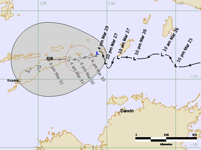
+12: 29/1200: 8.1S 128.9E: 080 [150]: 030 [055]: 1002
+24: 30/0000: 8.2S 127.6E: 110 [205]: 040 [075]: 998
+36: 30/1200: 8.5S 126.7E: 145 [265]: 040 [075]: 997
+48: 31/0000: 8.4S 125.4E: 175 [325]: 040 [075]: 998
+60: 31/1200: 8.2S 122.8E: 225 [415]: :
+72: 01/0000: 7.8S 120.2E: 270 [500]: :
REMARKS:
Tropical low has exhibited good convective development overnight. Low level
circulation centre is obscured beneath convection, so position is uncertain,
based on 2330UTC MTSAT vis imagery. Dvorak FT of 2.0 based on MET of 2.5
reduced to 2.0 in PT. DT based on spiral wrap which has fluctuated between 0.35
at 2230 UTC and 0.2 at 2330 UTC vis imagery, so on average in 1.5 +/- 0.5 range.


Environmental vertical shear has decreased significantly recently, allowing
development which is forecast to continue at standard rate in short term.
Longer term intensity forecast is uncertain as it will depend sensitively on
track and resulting effect of islands, in particular the mountains of Timor.
Dry air from the south may also become an inhibiting factor in the longer term.
Therefore development forecast has been held at T3.0.

Low has been moving very slowly west for last 24 hours. Model consensus track
suggests slow westward movement initially followed by an acceleration to the
west. Westward movement is consistent with the current mid-level ridge to the
south, but model forecasts suggest that the 500hPa ridge will weaken in the next
few days as a trough approaches Australia from the Indian Ocean, so model
westward acceleration in that time frame may be a due to models representing the
system as a shallow circulation being steered by the lower levels of the
atmosphere. If it is still a deep system in the next 2-3 days it may more more
slowly west than suggested by NWP consensus. Forecast track is based on
consensus slowed down to account for this possibility, and speed of longer-term
westward motion is quite uncertain.


Copyright Commonwealth of Australia
==
The next bulletin for this system will be issued by: 29/0730 UTC by Darwin TCWC.
0 likes   

User avatar
HURAKAN
Professional-Met
Professional-Met
Posts: 46086
Age: 37
Joined: Thu May 20, 2004 4:34 pm
Location: Key West, FL
Contact:

#4 Postby HURAKAN » Sun Mar 29, 2009 6:46 am

Image

TROPICAL CYCLONE TECHNICAL BULLETIN: AUSTRALIA - NORTHERN REGION
Issued by DARWIN TROPICAL CYCLONE WARNING CENTRE
at: 0735 UTC 29/03/2009
Name: Tropical Low
Identifier: 21U
Data At: 0600 UTC
Latitude: 8.1S
Longitude: 129.3E
Location Accuracy: within 50 nm [95 km]
Movement Towards: south [180 deg]
Speed of Movement: 1 knot [1 km/h]
Maximum 10-Minute Wind: 25 knots [45 km/h]
Maximum 3-Second Wind Gust: 45 knots [85 km/h]
Central Pressure: 1002 hPa
Radius of 34-knot winds NE quadrant:
Radius of 34-knot winds SE quadrant:
Radius of 34-knot winds SW quadrant:
Radius of 34-knot winds NW quadrant:
Radius of 48-knot winds NE quadrant:
Radius of 48-knot winds SE quadrant:
Radius of 48-knot winds SW quadrant:
Radius of 48-knot winds NW quadrant:
Radius of 64-knot winds:
Radius of Maximum Winds:
Dvorak Intensity Code: T2.0/2.0/D1.0/24HRS
Pressure of outermost isobar: 1006 hPa
Radius of outermost closed isobar: 90 nm [165 km]
Storm Depth: Medium
FORECAST DATA
Date/Time : Location : Loc. Accuracy: Max Wind : Central Pressure
[UTC] : degrees : nm [km]: knots[km/h]: hPa
+12: 29/1800: 8.3S 128.8E: 080 [150]: 035 [065]: 998
+24: 30/0600: 8.5S 128.0E: 110 [205]: 040 [075]: 995
+36: 30/1800: 8.5S 127.3E: 140 [265]: 040 [075]: 995
+48: 31/0600: 8.5S 125.7E: 175 [325]: 030 [055]: 1001
+60: 31/1800: 8.3S 124.1E: 220 [410]: 030 [055]: 1001
+72: 01/0600: 7.6S 121.8E: 270 [500]: 030 [055]: 1002
REMARKS:
Tropical low has exhibited good convective development overnight. Low level
circulation centre is obscured beneath cirrus, so position, based on 0530UTC
MTSAT vis imagery, is poor, but is supported by 0149UTC TRMM 85 GHz imagery.
Dvorak FT of 2.0 based on MET of 2.5 reduced to 2.0 in PT. DT based on spiral
wrap of 0.25 [Vis] or 0.35 [IR], so on average in DT 1.5 +/- 0.5 range.

Environmental vertical shear has decreased significantly recently, allowing
development which is forecast to continue at standard rate in short term.
Longer term intensity forecast is uncertain as it will depend sensitively on
track and resulting effect of islands, in particular the mountains of Timor.
Dry air from the south may also become an inhibiting factor in the longer term.


Low has become slow moving in last 12 hours. Latest model consensus [06Z GFS,
00Z TXLAPS, JMA, UK and 12Z EC] has the system slow moving then moving westward
over Timor and weakening after interaction with the island. Westward movement
is consistent with the current mid-level ridge to the south. Model forecasts
suggest that the 500hPa ridge will weaken in the next few days as a trough
approaches Australia from the Indian Ocean, but by that stage the weakened
system will be more influenced by the low level easterly flow which will push it
more quickly west.

Intensity forecast based on expected track has weakening below cyclone intensity
in 48 hours as the system interacts with East Timor, but if the system is slower
moving or takes a more southwesterly track than forecast, there is potential for
the system to retain cyclone intensity for longer.


Copyright Commonwealth of Australia
==
The next bulletin for this system will be issued by: 29/1330 UTC by Darwin TCWC.
0 likes   

User avatar
HURAKAN
Professional-Met
Professional-Met
Posts: 46086
Age: 37
Joined: Thu May 20, 2004 4:34 pm
Location: Key West, FL
Contact:

Re: Banda Sea: Invest 90P

#5 Postby HURAKAN » Sun Mar 29, 2009 6:48 am

Image

Image

WTXS21 PGTW 290900
MSGID/GENADMIN/NAVMARFCSTCEN PEARL HARBOR HI/JTWC//
SUBJ/TROPICAL CYCLONE FORMATION ALERT//
RMKS/
1. FORMATION OF A SIGNIFICANT TROPICAL CYCLONE IS POSSIBLE WITHIN
095 NM EITHER SIDE OF A LINE FROM 8.4S 129.6E TO 8.4S 126.7E
WITHIN THE NEXT 12 TO 24 HOURS. AVAILABLE DATA DOES NOT JUSTIFY
ISSUANCE OF NUMBERED TROPICAL CYCLONE WARNINGS AT THIS TIME.
WINDS IN THE AREA ARE ESTIMATED TO BE 25 TO 30 KNOTS. METSAT IM-
AGERY AT 290730Z INDICATES THAT A CIRCULATION CENTER IS LOCATED
NEAR 8.2S 129.3E. THE SYSTEM IS MOVING WESTWARD AT 04 KNOTS.
2. REMARKS: THE AREA OF CONVECTION PREVIOUSLY LOCATED 8.5S 129.6E IS
NOW LOCATED NEAR 8.2S 129.3E, APPROXIMATELY 280 NM NORTH-NORTHWEST OF
DARWIN, AUSTRALIA. RECENT ANIMATED MULTISPECTRAL IMAGERY INDICATES
INCREASED CONVECTION BEGINNING TO FORM INTO BANDS WRAPPING INTO THE
LOW LEVEL CIRCULATION CENTER. A 200 MB ANTICYCLONE PREVIOUSLY OVER
NORTHERN AUSTRALIA HAS MOVED NORTHWARD AND IS NOW POSITIONED OVER THE
DISTURBANCE. THIS ANTICYCLONE IS CONTRIBUTING TO GOOD DIFFLUENCE
ALOFT AND LOW VERTICAL WIND SHEAR, MAKING THE UPPER LEVEL ENVIRONMENT
FAVORABLE FOR FURTHER DEVELOPMENT. MINIMUM SEA LEVEL PRESSURE IS
ESTIMATED TO BE NEAR 1004 MB. THE POTENTIAL FOR THE DEVELOPMENT OF A
SIGNIFICANT TROPICAL CYCLONE WITHIN THE NEXT 24 HOURS IS GOOD.
3. THIS ALERT WILL BE REISSUED, UPGRADED TO WARNING OR CANCELLED BY
300900Z.
0 likes   

User avatar
KWT
Category 5
Category 5
Posts: 31390
Joined: Tue Aug 17, 2004 11:02 am
Location: UK!!!

#6 Postby KWT » Sun Mar 29, 2009 7:55 am

Looks like its heading right into land so even if it forms it probably won't last long.
0 likes   

User avatar
Chacor
Category 5
Category 5
Posts: 10229
Joined: Mon Oct 02, 2006 10:43 pm
Location: Singapore

#7 Postby Chacor » Sun Mar 29, 2009 10:47 am

AXAU01 ADRM 291344
IDD20020
TROPICAL CYCLONE TECHNICAL BULLETIN: AUSTRALIA - NORTHERN REGION
Issued by DARWIN TROPICAL CYCLONE WARNING CENTRE
at: 1343 UTC 29/03/2009
Name: Tropical Low
Identifier: 21U
Data At: 1200 UTC
Latitude: 8.5S
Longitude: 129.3E
Location Accuracy: within 65 nm [120 km]
Movement Towards: near stationary
Speed of Movement: slow
Maximum 10-Minute Wind: 25 knots [45 km/h]
Maximum 3-Second Wind Gust: 45 knots [85 km/h]
Central Pressure: 1005 hPa
Radius of 34-knot winds NE quadrant:
Radius of 34-knot winds SE quadrant:
Radius of 34-knot winds SW quadrant:
Radius of 34-knot winds NW quadrant:
Radius of 48-knot winds NE quadrant:
Radius of 48-knot winds SE quadrant:
Radius of 48-knot winds SW quadrant:
Radius of 48-knot winds NW quadrant:
Radius of 64-knot winds:
Radius of Maximum Winds:
Dvorak Intensity Code: T1.5/2.0/D0.5/24HRS
Pressure of outermost isobar: 1008 hPa
Radius of outermost closed isobar: 90 nm [165 km]
Storm Depth: Medium
FORECAST DATA
Date/Time : Location : Loc. Accuracy: Max Wind : Central Pressure
[UTC] : degrees : nm [km]: knots[km/h]: hPa
+12: 30/0000: 8.6S 128.9E: 095 [175]: 035 [065]: 999
+24: 30/1200: 8.6S 128.5E: 125 [230]: 040 [075]: 996
+36: 31/0000: 8.7S 127.7E: 160 [290]: 045 [085]: 994
+48: 31/1200: 8.6S 126.0E: 190 [350]: 030 [055]: 1003

REMARKS:
The low level circulation centre remains difficult to locate accurately on
infrared satellite imagery, so position, based on 1130UTC MTSAT IR imagery, is
poor, but is supported by 0930UTC scatterometer winds. Dvorak FT of 1.5 based
on MET of 2.0 reduced to 1.5 in PT. DT based on spiral wrap of 0.2 [IR], so on
average in DT 1.5 +/- 0.5 range.

Environmental vertical shear has decreased significantly over the last 24 hours,
allowing development which is forecast to continue in short term. Longer term
intensity forecast remains uncertain due to the proximity of nearby land,
particularly the mountains of Timor. Dry air from the south may also become an
inhibiting factor in the longer term.

Latest model consensus [06UTC GFS, 00UTC TXLAPS, JMA, UK and EC] maintains slow
system movement in the short-term, and then westward over Timor. The low is
expected to weaken significantly over Timor due to interaction with the land.

Intensity forecast based on expected track has the system weakening below
cyclone intensity in 48 hours as the system interacts with East Timor, but if
the system is slower moving or takes a more southwesterly track than forecast,
there is potential for the system to retain cyclone intensity for longer.


Copyright Commonwealth of Australia
==
The next bulletin for this system will be issued by: 29/1930 UTC by Darwin TCWC.
0 likes   

User avatar
HURAKAN
Professional-Met
Professional-Met
Posts: 46086
Age: 37
Joined: Thu May 20, 2004 4:34 pm
Location: Key West, FL
Contact:

#8 Postby HURAKAN » Sun Mar 29, 2009 6:35 pm

TROPICAL CYCLONE OUTLOOK
FOR THE AREA BETWEEN LONGITUDES 125 EAST - 142 EAST
Issued by the BUREAU OF METEOROLOGY, DARWIN
at 2:15 pm CST Sunday 29 March 2009

A developing TROPICAL LOW, 1004 hPa, is situated in the southern BANDA SEA. At
11am Sunday the low was centred near latitude 8.0S longitude 129.2E, about 530
km north northwest of Darwin, moving slowly west. The TROPICAL LOW is expected
to continue moving to the west during the next few days. The TROPICAL LOW may
intensify further, but it is not expected to threaten the North Australian coast
during the next three days, and may have weakened or moved out of the Outlook
area by Wednesday.

The likelihood of a Tropical Cyclone occurring in the region in the next three
days is:
Monday: high,
Tuesday: moderate,
Wednesday: low.

NOTE: Development Potential is an estimate of the probability of tropical
cyclone development for each day... Low = 10% or less, Moderate = 20% - 40%,
High = 50% or more.

DARWIN Regional Forecasting Centre.
0 likes   

User avatar
HURAKAN
Professional-Met
Professional-Met
Posts: 46086
Age: 37
Joined: Thu May 20, 2004 4:34 pm
Location: Key West, FL
Contact:

#9 Postby HURAKAN » Sun Mar 29, 2009 9:12 pm

TROPICAL CYCLONE TECHNICAL BULLETIN: AUSTRALIA - NORTHERN REGION
Issued by DARWIN TROPICAL CYCLONE WARNING CENTRE
at: 0158 UTC 30/03/2009
Name: Tropical Low
Identifier: 21U
Data At: 0000 UTC
Latitude: 9.0S
Longitude: 129.0E
Location Accuracy: within 90 nm [165 km]
Movement Towards: near stationary
Speed of Movement: 3 knots [5 km/h]
Maximum 10-Minute Wind: 25 knots [45 km/h]
Maximum 3-Second Wind Gust: 45 knots [85 km/h]
Central Pressure: 1005 hPa
Radius of 34-knot winds NE quadrant:
Radius of 34-knot winds SE quadrant:
Radius of 34-knot winds SW quadrant:
Radius of 34-knot winds NW quadrant:
Radius of 48-knot winds NE quadrant:
Radius of 48-knot winds SE quadrant:
Radius of 48-knot winds SW quadrant:
Radius of 48-knot winds NW quadrant:
Radius of 64-knot winds:
Radius of Maximum Winds:
Dvorak Intensity Code: T1.5/1.5/W0.5/24HRS
Pressure of outermost isobar: 1008 hPa
Radius of outermost closed isobar: 1008 nm [250 km]
Storm Depth:
FORECAST DATA
Date/Time : Location : Loc. Accuracy: Max Wind : Central Pressure
[UTC] : degrees : nm [km]: knots[km/h]: hPa
+12: 30/1200: 9.2S 128.5E: 120 [220]: 030 [055]: 1002
+24: 31/0000: 9.0S 127.6E: 150 [280]: 035 [065]: 998
+36: 31/1200: 8.3S 126.9E: 180 [340]: 030 [055]: 1001
+48: 01/0000: 7.6S 124.1E: 215 [400]: 025 [045]: 1007
+60: 01/1200: 7.1S 122.3E: 260 [485]: 025 [045]: 1006
+72: 02/0000: : : :

REMARKS:
The low level circulation centre remains difficult to locate and is under an
area of disorganised deep convection. Poor position fix based on 2330UTC MTSAT
VIS imagery and persistence. Dvorak FT of 1.5 based on PAT 1.5, with MET of 2.0
and steady 24-hour change. No reliable DT assessment possible, although LLCC is
close to the edge of cold cloud, so DT=1.5/2.0 based on shear pattern.

Despite vertical wind shear and upper divergence remaining favourable for
further development, there has been a reduction in cloud organisation during the
past 24 hours. Ingestion of dry air from the northwest, the lack of a
well-defined middle-level circulation and an unfavourable broadscale environment
[lack of low-level wind surges and inactive MJO phase] may be factors affecting
the system.

Slow westward movement is forecast initially, then steady west northwest
movement under the influence of a strengthening low- to mid-level ridge to the
south. Dry air is expected to advect into the area within 24-48 hours.

The intensity forecast indicates marginal TC intensity at the diurnally
favourable time of 1800 UTC Tuesday, then constant intensity until landfall on
the south coast of East Timor later the same day. If the low takes a more
westward track, TC intensity may be maintained for a slightly longer period.

Rapid weakening is forecast after landfall due to interaction with high
topography, but reintensification to TC intensity is unlikely after the system
move back over waters to the north of Timor.

Copyright Commonwealth of Australia
==
The next bulletin for this system will be issued by: 30/0730 UTC by Darwin TCWC.
0 likes   

User avatar
Chacor
Category 5
Category 5
Posts: 10229
Joined: Mon Oct 02, 2006 10:43 pm
Location: Singapore

#10 Postby Chacor » Mon Mar 30, 2009 6:17 am

AXAU01 ADRM 300748
IDD20020
TROPICAL CYCLONE TECHNICAL BULLETIN: AUSTRALIA - NORTHERN REGION
Issued by DARWIN TROPICAL CYCLONE WARNING CENTRE
at: 0748 UTC 30/03/2009
Name: Tropical Low
Identifier: 21U
Data At: 0600 UTC
Latitude: 9.1S
Longitude: 128.6E
Location Accuracy: within 90 nm [165 km]
Movement Towards: near stationary
Speed of Movement: 4 knots [7 km/h]
Maximum 10-Minute Wind: 25 knots [45 km/h]
Maximum 3-Second Wind Gust: 45 knots [85 km/h]
Central Pressure: 1005 hPa
Radius of 34-knot winds NE quadrant:
Radius of 34-knot winds SE quadrant:
Radius of 34-knot winds SW quadrant:
Radius of 34-knot winds NW quadrant:
Radius of 48-knot winds NE quadrant:
Radius of 48-knot winds SE quadrant:
Radius of 48-knot winds SW quadrant:
Radius of 48-knot winds NW quadrant:
Radius of 64-knot winds:
Radius of Maximum Winds:
Dvorak Intensity Code: T1.5/2.0/S0.0/24HRS
Pressure of outermost isobar: 1008 hPa
Radius of outermost closed isobar: 1008 nm [250 km]
Storm Depth:
FORECAST DATA
Date/Time : Location : Loc. Accuracy: Max Wind : Central Pressure
[UTC] : degrees : nm [km]: knots[km/h]: hPa
+12: 30/1800: 9.1S 127.9E: 120 [220]: 030 [055]: 1002
+24: 31/0600: 9.0S 127.1E: 150 [280]: 035 [065]: 1000
+36: 31/1800: 8.7S 125.8E: 180 [340]: 030 [055]: 1003
+48: 01/0600: 7.9S 123.2E: 220 [405]: 025 [045]: 1006
+60: 01/1800: : : :
+72: 02/0600: : : :

REMARKS:
The low level circulation centre remains difficult to locate under high-level
cloud. Convective structure remains disorganised with an area of deep convection
being sheared to the southeast of the LLCC. Poor position fix based on MTSAT VIS
animation and persistence. Dvorak DT=1.5 based on shear pattern with LLCC
greater than 1.25deg from overcast. FT=MET=1.5 but CI held at 2.0.

Vertical wind shear has increased, with low-level easterly steering flow below
700 hPa and westerly flow in mid-levels associated with a deep trough over
eastern Australia. Some dry air may have restricted convection in the northwest
sector which combined with increasing shear and an inactive MJO phase has
limited the intensification of the low during the past 24 hours.

Intensity forecast assumes intensification overnight and slow westward movement
under light mid-level steering. Movement may be faster towards the west if the
low remains ill-defined and shallow. The intensity forecast indicates marginal
TC intensity by 0000 UTC Tuesday, then landfall on the south coast of East Timor
overnight.Rapid weakening is forecast after landfall due to interaction with
high topography and reintensification to TC intensity is unlikely after the
system moves back over waters to the north of Timor.

Copyright Commonwealth of Australia
==
The next bulletin for this system will be issued by: 30/1330 UTC by Darwin TCWC.
0 likes   

User avatar
HURAKAN
Professional-Met
Professional-Met
Posts: 46086
Age: 37
Joined: Thu May 20, 2004 4:34 pm
Location: Key West, FL
Contact:

#11 Postby HURAKAN » Mon Mar 30, 2009 7:55 am

Image

So far, nothing to get excited.
0 likes   

User avatar
HURAKAN
Professional-Met
Professional-Met
Posts: 46086
Age: 37
Joined: Thu May 20, 2004 4:34 pm
Location: Key West, FL
Contact:

#12 Postby HURAKAN » Mon Mar 30, 2009 8:40 am

TROPICAL CYCLONE TECHNICAL BULLETIN: AUSTRALIA - NORTHERN REGION
Issued by DARWIN TROPICAL CYCLONE WARNING CENTRE
at: 1340 UTC 30/03/2009
Name: Tropical Low
Identifier: 21U
Data At: 1200 UTC
Latitude: 9.1S
Longitude: 128.4E
Location Accuracy: within 90 nm [165 km]
Movement Towards: west [260 deg]
Speed of Movement: 3 knots [6 km/h]
Maximum 10-Minute Wind: 25 knots [45 km/h]
Maximum 3-Second Wind Gust: 45 knots [85 km/h]
Central Pressure: 1003 hPa
Radius of 34-knot winds NE quadrant:
Radius of 34-knot winds SE quadrant:
Radius of 34-knot winds SW quadrant:
Radius of 34-knot winds NW quadrant:
Radius of 48-knot winds NE quadrant:
Radius of 48-knot winds SE quadrant:
Radius of 48-knot winds SW quadrant:
Radius of 48-knot winds NW quadrant:
Radius of 64-knot winds:
Radius of Maximum Winds:
Dvorak Intensity Code: T1.5/1.5/S0.0/24HRS
Pressure of outermost isobar: 1006 hPa
Radius of outermost closed isobar: 1008 nm [250 km]
Storm Depth: Medium
FORECAST DATA
Date/Time : Location : Loc. Accuracy: Max Wind : Central Pressure
[UTC] : degrees : nm [km]: knots[km/h]: hPa
+12: 31/0000: 8.9S 127.6E: 120 [220]: 030 [055]: 1001
+24: 31/1200: 8.5S 126.3E: 150 [280]: 025 [045]: 1004
+36: 01/0000: 7.9S 124.1E: 180 [340]: 025 [045]: 1004
+48: 01/1200: 7.9S 121.7E: 215 [400]: 025 [045]: 1005
+60: 02/0000: 8.2S 118.9E: 260 [485]: 025 [045]: 1004
+72: 02/1200: 8.6S 116.3E: 310 [570]: 025 [045]: 1005

REMARKS:
The low level circulation centre remains difficult to locate under high-level
cloud. Convective structure remains disorganised with an area of deep convection
to the east of the LLCC. Poor position fix based on MTSAT IR animation and
persistence. Dvorak DT<1.5 based on 0.2 wrap curved band. MET=1.0 but FT/CI
based on PT of 1.5.

Increasing low to mid-level shear has limited the intensification of the low
during the past 24 hours.

TC formation now seems more uncertain. Intensity forecast assumes
intensification overnight and slow westward movement under light mid-level
steering. Movement may be faster towards the west if the low remains ill-defined
and shallow. The intensity forecast indicates marginal TC intensity by 0600 UTC
Tuesday, then landfall on the south coast of East Timor overnight. Rapid
weakening is forecast after landfall due to interaction with high topography and
reintensification to TC intensity is unlikely after the system moves back over
waters to the north of Timor, particularly with forecast increase of dry air
from the south.

Copyright Commonwealth of Australia
==
The next bulletin for this system will be issued by: 30/1930 UTC by Darwin TCWC.
0 likes   

User avatar
Chacor
Category 5
Category 5
Posts: 10229
Joined: Mon Oct 02, 2006 10:43 pm
Location: Singapore

#13 Postby Chacor » Mon Mar 30, 2009 9:29 am

Still expecting a TC, even if it isn't expressly shown in the forecast data.

AXAU01 ADRM 301340
IDD20020
TROPICAL CYCLONE TECHNICAL BULLETIN: AUSTRALIA - NORTHERN REGION
Issued by DARWIN TROPICAL CYCLONE WARNING CENTRE
at: 1340 UTC 30/03/2009
Name: Tropical Low
Identifier: 21U
Data At: 1200 UTC
Latitude: 9.1S
Longitude: 128.4E
Location Accuracy: within 90 nm [165 km]
Movement Towards: west [260 deg]
Speed of Movement: 3 knots [6 km/h]
Maximum 10-Minute Wind: 25 knots [45 km/h]
Maximum 3-Second Wind Gust: 45 knots [85 km/h]
Central Pressure: 1003 hPa
Radius of 34-knot winds NE quadrant:
Radius of 34-knot winds SE quadrant:
Radius of 34-knot winds SW quadrant:
Radius of 34-knot winds NW quadrant:
Radius of 48-knot winds NE quadrant:
Radius of 48-knot winds SE quadrant:
Radius of 48-knot winds SW quadrant:
Radius of 48-knot winds NW quadrant:
Radius of 64-knot winds:
Radius of Maximum Winds:
Dvorak Intensity Code: T1.5/1.5/S0.0/24HRS
Pressure of outermost isobar: 1006 hPa
Radius of outermost closed isobar: 1008 nm [250 km]
Storm Depth: Medium
FORECAST DATA
Date/Time : Location : Loc. Accuracy: Max Wind : Central Pressure
[UTC] : degrees : nm [km]: knots[km/h]: hPa
+12: 31/0000: 8.9S 127.6E: 120 [220]: 030 [055]: 1001
+24: 31/1200: 8.5S 126.3E: 150 [280]: 025 [045]: 1004
+36: 01/0000: 7.9S 124.1E: 180 [340]: 025 [045]: 1004
+48: 01/1200: 7.9S 121.7E: 215 [400]: 025 [045]: 1005
+60: 02/0000: 8.2S 118.9E: 260 [485]: 025 [045]: 1004
+72: 02/1200: 8.6S 116.3E: 310 [570]: 025 [045]: 1005

REMARKS:
The low level circulation centre remains difficult to locate under high-level
cloud. Convective structure remains disorganised with an area of deep convection
to the east of the LLCC. Poor position fix based on MTSAT IR animation and
persistence. Dvorak DT<1.5 based on 0.2 wrap curved band. MET=1.0 but FT/CI
based on PT of 1.5.

Increasing low to mid-level shear has limited the intensification of the low
during the past 24 hours.

TC formation now seems more uncertain. Intensity forecast assumes
intensification overnight and slow westward movement under light mid-level
steering. Movement may be faster towards the west if the low remains ill-defined
and shallow. The intensity forecast indicates marginal TC intensity by 0600 UTC
Tuesday, then landfall on the south coast of East Timor overnight.
Rapid
weakening is forecast after landfall due to interaction with high topography and
reintensification to TC intensity is unlikely after the system moves back over
waters to the north of Timor, particularly with forecast increase of dry air
from the south.

Copyright Commonwealth of Australia
==
The next bulletin for this system will be issued by: 30/1930 UTC by Darwin TCWC.
0 likes   

User avatar
HURAKAN
Professional-Met
Professional-Met
Posts: 46086
Age: 37
Joined: Thu May 20, 2004 4:34 pm
Location: Key West, FL
Contact:

#14 Postby HURAKAN » Mon Mar 30, 2009 10:33 am

Image
0 likes   

User avatar
cycloneye
Admin
Admin
Posts: 139019
Age: 67
Joined: Thu Oct 10, 2002 10:54 am
Location: San Juan, Puerto Rico

Re: Banda Sea: Invest 90P - TCFA

#15 Postby cycloneye » Mon Mar 30, 2009 6:49 pm

TCFA canceled:

WTXS21 PGTW 302100
MSGID/GENADMIN/NAVMARFCSTCEN PEARL HARBOR HI/JTWC//
SUBJ/TROPICAL CYCLONE FORMATION ALERT CANCELLATION//
REF/A/RMG/NAVMARFCSTCEN PEARL HARBOR HI/300051ZMAR2009//
AMPN/REF A IS TROPICAL CYCLONE FORMATION ALERT (WTXS21 PGTW 300100)//
RMKS/
1. REMARKS: THIS CANCELS REF A. RECENT ANIMATED INFRARED IMAGERY
SHOWS THE CIRCULATION HAS SIGNIFICANTLY WEAKENED WITH A DRAMATIC
LOSS OF CONVECTION NEAR THE LOW LEVEL CIRCULATION CENTER (LLCC). A
300907 QUIKSCAT IMAGE SHOWS ELONGATED TROUGHING ON THE SURFACE IN
THE VICINITY OF BABAR ISLAND, INDONESIA. UPPER LEVEL ANALYSIS
INDICATES THAT THE LLCC IS NO LONGER UNDER THE UPPER LEVEL
ANTICYCLONE, AND IS SUBJECT TO LOW TO MODERATE LEVELS OF VERTICAL
WIND SHEAR. DUE TO THE VICINITY OF LAND TO THE LLCC AND THE UPPER
LEVEL ENVIRONMENT, THE POTENTIAL FOR THE DEVELOPMENT OF A
SIGNIFICANT TROPICAL CYCLONE WITHIN THE NEXT 24 HOURS IS DOWNGRADED
TO POOR.//
NNNN

Image
0 likes   

User avatar
Chacor
Category 5
Category 5
Posts: 10229
Joined: Mon Oct 02, 2006 10:43 pm
Location: Singapore

#16 Postby Chacor » Tue Mar 31, 2009 2:40 am

AXAU01 ADRM 310712
IDD20020
TROPICAL CYCLONE TECHNICAL BULLETIN: AUSTRALIA - NORTHERN REGION
Issued by DARWIN TROPICAL CYCLONE WARNING CENTRE
at: 0711 UTC 31/03/2009
Name: Tropical Low
Identifier: 21U
Data At: 0000 UTC
Latitude: 8.5S
Longitude: 129.5E
Location Accuracy: within 90 nm [165 km]
Movement Towards: near stationary
Speed of Movement: slow moving
Maximum 10-Minute Wind: 20 knots [35 km/h]
Maximum 3-Second Wind Gust: 45 knots [85 km/h]
Central Pressure: 1009 hPa
Radius of 34-knot winds NE quadrant:
Radius of 34-knot winds SE quadrant:
Radius of 34-knot winds SW quadrant:
Radius of 34-knot winds NW quadrant:
Radius of 48-knot winds NE quadrant:
Radius of 48-knot winds SE quadrant:
Radius of 48-knot winds SW quadrant:
Radius of 48-knot winds NW quadrant:
Radius of 64-knot winds:
Radius of Maximum Winds:
Dvorak Intensity Code: T1.5/1.5/W0.5/24HRS
Pressure of outermost isobar: 1010 hPa
Radius of outermost closed isobar: 1008 nm [250 km]
Storm Depth:
FORECAST DATA
Date/Time : Location : Loc. Accuracy: Max Wind : Central Pressure
[UTC] : degrees : nm [km]: knots[km/h]: hPa
+12: 31/1200: 8.0S 128.7E: 120 [220]: 020 [035]: 1011
+24: 01/0000: 7.5S 127.5E: 150 [280]: 025 [045]: 1009
+36: 01/1200: 7.3S 126.0E: 180 [340]: 025 [045]: 1009
+48: 02/0000: 7.7S 124.0E: 215 [400]: 020 [035]: 1011
+60: 02/1200: : : :
+72: 03/0000: : : :

REMARKS:
The low remains weak and disorganised, and has shown no improvement in structure
during the past 12 hours. Scatterometer data indicates a very weak LLCC located
to the north of the main area of deep convection, near 8S 128E. The mid-level
circulation centre that was evident in IR animation yesterday has drifted east
southeast under the influence of a trough over eastern Australia. Convection
associated with this feature has weakened. Dvorak DT was unclassifiable; FT
based on PAT=1.5 adjusted down from MET=2.0.

TC formation is now unlikely due to low to mid-level dry air advecting into the
area associated with a strong ridge to the southeast. The weak tropical low is
forecast to move with low-level steering flow towards the west northwest,
passing into the Banda Sea, to the north of the island of Timor.

Copyright Commonwealth of Australia
==
There will be no further bulletins for this system unless it reintensifies.
0 likes   

User avatar
KWT
Category 5
Category 5
Posts: 31390
Joined: Tue Aug 17, 2004 11:02 am
Location: UK!!!

#17 Postby KWT » Tue Mar 31, 2009 4:30 am

So it seems like we won't get a TC with this invest afterall then, not surprising given how close it is to land as well.
0 likes   

Grifforzer
Category 1
Category 1
Posts: 418
Joined: Thu Feb 26, 2009 11:27 pm

#18 Postby Grifforzer » Wed Apr 01, 2009 12:47 am

Tropical Cyclone Warning Center Perth
TROPICAL CYCLONE OUTLOOK
Forecast for area south of 10S between 110E-125E
2:00 PM WDT April 1 2009
=====================================
There are no significant tropical lows evident in the region. A slow moving low near 9S 129E is expected to drift slowly westwards [outside the region] but is not expected to develop into a tropical cyclone.

The likelihood of a tropical cyclone occurring in the next three days is:
Wednesday : Low
Thursday : Low
Friday : Low

** NOTE: Development potential is an estimate of the probability of **
** tropical cyclone development within a 24 hour period. **
** LOW = 10% or less MODERATE = 20-40% HIGH = 50% or more **
0 likes   


Return to “2009”

Who is online

Users browsing this forum: No registered users and 21 guests