EAST COAST : Tropical Depression ONE

Moderator: S2k Moderators

Message
Author
User avatar
cycloneye
Admin
Admin
Posts: 139019
Age: 67
Joined: Thu Oct 10, 2002 10:54 am
Location: San Juan, Puerto Rico

Re: Recon : INVEST 91L

#41 Postby cycloneye » Tue May 26, 2009 1:01 pm

wxman57 wrote:
cycloneye wrote:First mission will depart at 1:30 PM EDT on Tuesday.... snip...


You meant Wednesday, right? There's no recon scheduled for today, is there?


Yes Wednesday :)
0 likes   

User avatar
HURAKAN
Professional-Met
Professional-Met
Posts: 46086
Age: 37
Joined: Thu May 20, 2004 4:34 pm
Location: Key West, FL
Contact:

#42 Postby HURAKAN » Tue May 26, 2009 1:02 pm

Image

Convection is shallow at best.
0 likes   

User avatar
HURAKAN
Professional-Met
Professional-Met
Posts: 46086
Age: 37
Joined: Thu May 20, 2004 4:34 pm
Location: Key West, FL
Contact:

#43 Postby HURAKAN » Tue May 26, 2009 1:10 pm

Image

Image
0 likes   

OuterBanker
S2K Supporter
S2K Supporter
Posts: 1704
Joined: Wed Feb 26, 2003 10:53 am
Location: Nags Head, NC
Contact:

#44 Postby OuterBanker » Tue May 26, 2009 1:30 pm

If this were August (or even July) this could be a real concern. But let's face it the SST's just won't support much convection. We maybe could receive some rain and a little wind, nothing we aren't used too.

On the other hand we already have had two close in developments, is this a sign of the season to come?

Let's hope not.
0 likes   

User avatar
cycloneye
Admin
Admin
Posts: 139019
Age: 67
Joined: Thu Oct 10, 2002 10:54 am
Location: San Juan, Puerto Rico

Re: Model Guidance : INVEST 91L

#45 Postby cycloneye » Tue May 26, 2009 1:32 pm

18:00 UTC Model Suite


WHXX01 KWBC 261827
CHGHUR
TROPICAL CYCLONE GUIDANCE MESSAGE
NWS TPC/NATIONAL HURRICANE CENTER MIAMI FL
1827 UTC TUE MAY 26 2009

DISCLAIMER...NUMERICAL MODELS ARE SUBJECT TO LARGE ERRORS.
PLEASE REFER TO NHC OFFICIAL FORECASTS FOR TROPICAL CYCLONE
AND SUBTROPICAL CYCLONE INFORMATION.

ATLANTIC OBJECTIVE AIDS FOR

DISTURBANCE INVEST (AL912009) 20090526 1800 UTC

...00 HRS... ...12 HRS... ...24 HRS. .. ...36 HRS...
090526 1800 090527 0600 090527 1800 090528 0600

LAT LON LAT LON LAT LON LAT LON
BAMS 30.6N 75.4W 32.2N 75.6W 34.1N 75.2W 36.0N 73.9W
BAMD 30.6N 75.4W 32.7N 75.5W 34.7N 74.8W 36.4N 72.8W
BAMM 30.6N 75.4W 32.4N 75.5W 34.3N 75.0W 36.0N 73.4W
LBAR 30.6N 75.4W 32.8N 74.9W 34.9N 73.8W 36.6N 71.7W
SHIP 25KTS 31KTS 37KTS 40KTS
DSHP 25KTS 31KTS 37KTS 40KTS

...48 HRS... ...72 HRS... ...96 HRS. .. ..120 HRS...
090528 1800 090529 1800 090530 1800 090531 1800

LAT LON LAT LON LAT LON LAT LON
BAMS 37.8N 71.2W 41.6N 62.9W 44.8N 52.4W 46.3N 46.3W
BAMD 37.7N 69.5W 39.1N 59.8W 38.6N 49.0W 35.3N 41.5W
BAMM 37.6N 70.5W 40.2N 61.4W 41.1N 49.4W 37.4N 40.1W
LBAR 37.8N 67.9W 38.1N 56.5W 35.6N 46.0W 28.1N 47.9W
SHIP 44KTS 47KTS 44KTS 36KTS
DSHP 44KTS 47KTS 44KTS 36KTS

...INITIAL CONDITIONS...
LATCUR = 30.6N LONCUR = 75.4W DIRCUR = 355DEG SPDCUR = 13KT
LATM12 = 28.0N LONM12 = 75.0W DIRM12 = 347DEG SPDM12 = 14KT
LATM24 = 25.3N LONM24 = 74.6W
WNDCUR = 25KT RMAXWD = 45NM WNDM12 = 20KT
CENPRS = 1010MB OUTPRS = 1013MB OUTRAD = 200NM SDEPTH = M
RD34NE = 0NM RD34SE = 0NM RD34SW = 0NM RD34NW = 0NM

0 likes   

User avatar
HURAKAN
Professional-Met
Professional-Met
Posts: 46086
Age: 37
Joined: Thu May 20, 2004 4:34 pm
Location: Key West, FL
Contact:

#46 Postby HURAKAN » Tue May 26, 2009 1:33 pm

18Z

AL, 91, 2009052618, , BEST, 0, 306N, 754W, 25, 1010

Pressure up 1 mb
0 likes   

User avatar
KWT
Category 5
Category 5
Posts: 31390
Joined: Tue Aug 17, 2004 11:02 am
Location: UK!!!

#47 Postby KWT » Tue May 26, 2009 2:49 pm

Convection is indeed shallow though will be interesting to see exactly what sort of state the core of this system is in, certainly not impossible that this is a subtropical type feature.
0 likes   

User avatar
wxman57
Moderator-Pro Met
Moderator-Pro Met
Posts: 22480
Age: 66
Joined: Sat Jun 21, 2003 8:06 pm
Location: Houston, TX (southwest)

Re: East Coast : INVEST 91L

#48 Postby wxman57 » Tue May 26, 2009 3:07 pm

Note that the NHC did not identify any areas of possible development on their graphical TDO. Surface obs suggest that the rotation we're seeing is aloft and nowhere near the surface.

It only has about another 24 hours before it begins accelerating off to the NNE, so not much time to organize. Looks like just a rainmaker for eastern NC.
0 likes   

User avatar
HURAKAN
Professional-Met
Professional-Met
Posts: 46086
Age: 37
Joined: Thu May 20, 2004 4:34 pm
Location: Key West, FL
Contact:

#49 Postby HURAKAN » Tue May 26, 2009 3:24 pm

Image
0 likes   

Aric Dunn
Category 5
Category 5
Posts: 21228
Age: 41
Joined: Sun Sep 19, 2004 9:58 pm
Location: Ready for the Chase.
Contact:

#50 Postby Aric Dunn » Tue May 26, 2009 4:03 pm

since things have not got going yet .. they probably will not .. but still needs to be watch as it will be passing over the gulf stream over the next 12 hours...
convection needs to develop for this to do any thing,...
0 likes   

Ed Mahmoud

Re: East Coast : INVEST 91L

#51 Postby Ed Mahmoud » Tue May 26, 2009 4:28 pm

JB says loss of daytime heating over land, warmer water of the Gulf Stream in its path, and a tighter pressure gradient as it heads toards high pressure will help refire storms and help this organize.


JB is a pro met...


Me, personally, not a pro-met, it looks pathetic, but I am a complete amateur.
0 likes   

capepoint
Category 1
Category 1
Posts: 414
Joined: Sat Jul 19, 2008 7:13 pm
Location: Beaufort, NC

#52 Postby capepoint » Tue May 26, 2009 4:44 pm

I'm on the Southern Outer Banks, (about 8 miles from Cape Lookout Lighthouse in fact) and the local mets say we will get more weather from the pressure gradient between this storm and a front moving in from northwest, than we will get from the storm itself. 40% chance of rain tomorrow from storm, but winds caused by gradient may gust 25 or so (not a big deal here, thats almost everyday! lol) from E and NE then go back southerly Thursday.
Cloudy, a few spotty showers, light sea-breeze from SW here today.
Welcome back from winter everyone!
0 likes   

User avatar
HURAKAN
Professional-Met
Professional-Met
Posts: 46086
Age: 37
Joined: Thu May 20, 2004 4:34 pm
Location: Key West, FL
Contact:

#53 Postby HURAKAN » Tue May 26, 2009 4:55 pm

Image

Chances of development appear low at best.
0 likes   

Aric Dunn
Category 5
Category 5
Posts: 21228
Age: 41
Joined: Sun Sep 19, 2004 9:58 pm
Location: Ready for the Chase.
Contact:

Re: East Coast : INVEST 91L

#54 Postby Aric Dunn » Tue May 26, 2009 4:57 pm

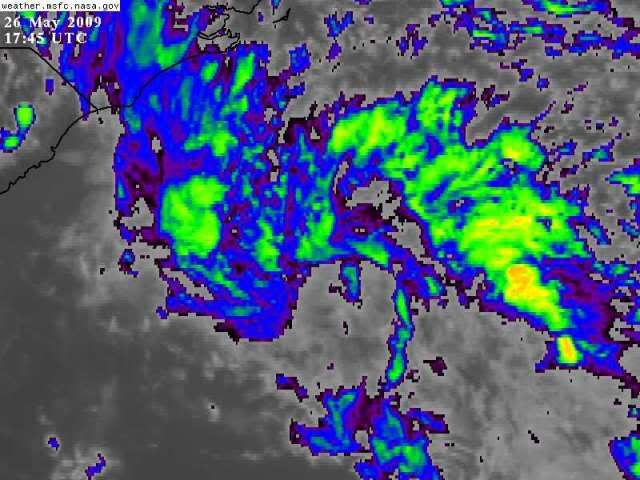
Ed Mahmoud wrote:JB says loss of daytime heating over land, warmer water of the Gulf Stream in its path, and a tighter pressure gradient as it heads toards high pressure will help refire storms and help this organize.


JB is a pro met...


Me, personally, not a pro-met, it looks pathetic, but I am a complete amateur.


right well that make sense.. we see that all the time.. coastal convection in the mornings near land dissipate as the land heats up and substance over the water develops... and with such a weak system it is possible that it can have that effect on it
also diurnal effects as well play a role.. will see the gulf is for sure warmer than where it is now.. the 12 hours will make or break any chances of this doing anything trop/sub trop..
0 likes   

xironman
S2K Supporter
S2K Supporter
Posts: 2159
Joined: Sun Jun 10, 2007 4:53 pm
Location: NoVA

Re: East Coast : INVEST 91L

#55 Postby xironman » Tue May 26, 2009 5:11 pm

When I look at the visible I see a good sized eddy way off to the west, around 31 - 78. I wonder how much energy that pulled out of the system.
0 likes   

User avatar
MGC
S2K Supporter
S2K Supporter
Posts: 5792
Joined: Sun Mar 23, 2003 9:05 pm
Location: Pass Christian MS, or what is left.

Re: East Coast : INVEST 91L

#56 Postby MGC » Tue May 26, 2009 5:33 pm

91L has a small chance...lets see what happens when 91L interacts with the Gulf Stream.....I've seen systems rapidly develope when over the GS......MGC
0 likes   

OpieStorm

Re: East Coast : INVEST 91L

#57 Postby OpieStorm » Tue May 26, 2009 5:37 pm

Wonder why the NHC has been so trigger happy with these invests. Both 90L and this one were hardly impressive.
0 likes   

User avatar
brunota2003
S2K Supporter
S2K Supporter
Posts: 9476
Age: 33
Joined: Sat Jul 30, 2005 9:56 pm
Location: Stanton, KY...formerly Havelock, NC
Contact:

#58 Postby brunota2003 » Tue May 26, 2009 6:22 pm

They can be used as tests for the models, that is why these invests have been tagged (plus you never know...90L got REALLY close)
0 likes   

User avatar
Tampa Bay Hurricane
Category 5
Category 5
Posts: 5594
Age: 36
Joined: Fri Jul 22, 2005 7:54 pm
Location: St. Petersburg, FL

#59 Postby Tampa Bay Hurricane » Tue May 26, 2009 7:23 pm

2nd close call in May!
First 90L which was extremely close to being Ana.
Now 91L.

I think we may briefly see something out of this, as in a depression
or minimal TS since it is over the Gulf Stream.

For May, 2009 has been hyperactive;
at this rate the heart of the season could total
17+ named storms (just my wild guess).
0 likes   

OpieStorm

Re: East Coast : INVEST 91L

#60 Postby OpieStorm » Tue May 26, 2009 7:36 pm

In my 15+ years of tracking tropical cyclones I never knew that 2 areas of thunderstomrs in May meant we were on pace to a hyperactive season.Interesting.
0 likes   


Return to “2009”

Who is online

Users browsing this forum: No registered users and 16 guests