EAST COAST : Tropical Depression ONE
Moderator: S2k Moderators
-
Lowpressure

- S2K Supporter

- Posts: 2032
- Age: 57
- Joined: Sun Sep 14, 2003 9:17 am
- Location: Charlotte, North Carolina
Re: East Coast : INVEST 91L
It is more interesting to me that it may signal a more active homebrew season. For the most part, the Carolinas have been VERY lucky the past few years. Pattern change is more of what I take from this.
0 likes
-
george_r_1961

- S2K Supporter
- Posts: 3171
- Age: 62
- Joined: Sat Oct 12, 2002 9:14 pm
- Location: Hampton, Virginia
Re: East Coast : INVEST 91L
Lowpressure wrote:It is more interesting to me that it may signal a more active homebrew season. For the most part, the Carolinas have been VERY lucky the past few years. Pattern change is more of what I take from this.
Exactly what I was thinking.
0 likes

Re: East Coast : INVEST 91L
xironman wrote:When I look at the visible I see a good sized eddy way off to the west, around 31 - 78. I wonder how much energy that pulled out of the system.
and that was where the NOAA site now puts the low (they still have it at 1010mb)
http://www.ssd.noaa.gov/goes/east/watl/loop-ir2.html zoom in and click fronts
0 likes
-
WeatherLovingDoc

- S2K Supporter
- Posts: 453
- Joined: Fri Sep 05, 2008 10:08 pm
- Location: Washington D.C.
Re: East Coast : INVEST 91L
Lowpressure wrote:It is more interesting to me that it may signal a more active homebrew season. For the most part, the Carolinas have been VERY lucky the past few years. Pattern change is more of what I take from this.
DH and I sat through a North Easter with a 6 week old on the Outer Banks back in late Sept/early Oct 1992. The house shook at times. I was desperate to see the ocean, having been on bed rest for months. Never felt in danger. Twice we complied with mandatory evacuations, one of which was Hurricane Hugo with young kids in tow. One ruined vacation week from tropical rain, where Route 12 actually caved in and cars couldn't get through for quite some time. Sure do hope the good luck to NC continues. The beaches are beautiful.
0 likes
-
Cainer

- Tropical Storm

- Posts: 188
- Age: 32
- Joined: Mon May 05, 2008 3:26 pm
- Location: Yarmouth, Nova Scotia
The last time we had two May invests was 2007 - and they became Andrea and Barry. Then, 2007 went on to have one of the lowest seasonal ACE's in recent years. Just thought I'd point out that there really is no correlation between early activity and the rest of the season.
In regards to 91L, I don't really think it has much going for it; low SST's, marginal shear, and not a lot of time. Still, it gives us something to follow in the run-up to the actual season
In regards to 91L, I don't really think it has much going for it; low SST's, marginal shear, and not a lot of time. Still, it gives us something to follow in the run-up to the actual season
0 likes


91L is a total non-event. Just a plume of moisture. Does not even have much of a tropical feel in the air tonight. NWS MHX apparently is not impressed at all either. They have issued only small craft advisories tomorrow and only for coastal waters north of lookout to hatteras out to 20nm.and NO advisiories for anywhere else. That is unbeleivably quiet for this time of year. Usually everything is SCA. Local mets tonight saying sinking air around low should even keep rain away tomorrow, so looks like another great day on the southern OBX! Maybe this invest was just to test our storm shield....lol 
0 likes
Re: East Coast : INVEST 91L
george_r_1961 wrote:Lowpressure wrote:It is more interesting to me that it may signal a more active homebrew season. For the most part, the Carolinas have been VERY lucky the past few years. Pattern change is more of what I take from this.
Exactly what I was thinking.
Hey!!! Easy guys, some of us live on these NC sandbanks you know. lol Don't jinx us.
0 likes
-
TropicalWXMA

- Tropical Storm
- Posts: 114
- Joined: Wed May 18, 2005 9:22 pm
- Location: Boston, MA
- Contact:


-
wxman57

- Moderator-Pro Met

- Posts: 22480
- Age: 66
- Joined: Sat Jun 21, 2003 8:06 pm
- Location: Houston, TX (southwest)
Re: East Coast : INVEST 91L
OpieStorm wrote:In my 15+ years of tracking tropical cyclones I never knew that 2 areas of thunderstomrs in May meant we were on pace to a hyperactive season.Interesting.
If the forecasters at the NHC really thought this system had much of a chance of developing then they'd identify it as a disturbance on the tropical outlook and issue a special statement or two. It's pretty clear they're just doing some testing to make sure all is well before the start of the season. This disturbance never had much of a chance. And the farther north it goes, the cooler the water. Even the Gulf Stream is a bit cool for development as far north as it is now.
With an increasing chance of a significant El Nino this season, and with SSTs much cooler than recent years (and the ITCZ well south for so early in the season), I think we're shaping up for a fairly quiet season numbers-wise. My 10/5/2 may be too high.
0 likes
Re: East Coast : INVEST 91L
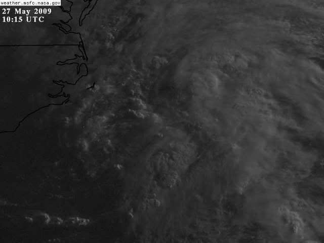
91L fail. It never seemed to get together, the mid level spin that dominated never hooked up with the lower stuff. It is pretty apparent on the visible that the low level spin was about here

You can it it on radar as well.

You can it it on radar as well.
0 likes

Re: East Coast : INVEST 91L
this radar shows a little rather out

Looking a little better this morning at least Invest worthy, but I don;t see any models that develop much out of this one. But Bears Watching.
Looking a little better this morning at least Invest worthy, but I don;t see any models that develop much out of this one. But Bears Watching.
0 likes

Re: East Coast : INVEST 91L
STW issued finally on this system. Note that they only give this system a low chance of development and plane is not a go yet. Also they are going to issue another outlook at 2pm this afternoon.
ZCZC MIATWOAT ALL
TTAA00 KNHC DDHHMM CCA
SPECIAL TROPICAL WEATHER OUTLOOK...CORRECTED
NWS TPC/NATIONAL HURRICANE CENTER MIAMI FL
810 AM EDT WED MAY 27 2009
CORRECTED TO ADD PROBABILITY OF TROPICAL CYCLONE FORMATION
FOR THE NORTH ATLANTIC...CARIBBEAN SEA AND THE GULF OF MEXICO...
1. AN AREA OF LOW PRESSURE ACCOMPANIED BY A FEW SHOWERS IS LOCATED
ABOUT 120 MILES SOUTH OF CAPE HATTERAS NORTH CAROLINA. WHILE
CONDITIONS ARE NOT FAVORABLE FOR SIGNIFICANT DEVELOPMENT...THE
SYSTEM HAS A BRIEF OPPORTUNITY TO BECOME A TROPICAL CYCLONE BEFORE
REACHING THE COLDER OCEAN TEMPERATURES NORTH OF THE CAROLINAS. AS
THE AREA OF LOW PRESSURE MOVES TOWARD THE NORTH AT 10-15 MPH...THE
SYSTEM COULD BRING SOME SHOWERS TO COASTAL NORTH CAROLINA LATER
TODAY. THERE IS A LOW CHANCE...LESS THAN 30 PERCENT...OF THIS
SYSTEM BECOMING A TROPICAL CYCLONE DURING THE NEXT 48 HOURS. AN
AIR FORCE RECONNAISSANCE AIRCRAFT WILL INVESTIGATE THE SYSTEM THIS
AFTERNOON...IF NECESSARY...AND AN ADDITIONAL SPECIAL TROPICAL
WEATHER OUTLOOK WILL BE ISSUED AT 2 PM EDT. SEE LOCAL WEATHER
FORECAST OFFICE PRODUCTS FOR ADDITIONAL INFORMATION.
$$
FORECASTER LANDSEA/FRANKLIN
NNNN
0 likes
-
srainhoutx

- S2K Supporter
- Posts: 6919
- Age: 66
- Joined: Sun Jan 14, 2007 11:34 am
- Location: Haywood County, NC
- Contact:
Re: East Coast : INVEST 91L
Another good practice run for what "may" turn out to be a less active season. I suspect RECON will get cancelled, but we shall see. Looks like my pre season 13/6/2 numbers may be in jeopardy as well.
0 likes

Re: East Coast : INVEST 91L
Unless, more convection develops around the center, I don't see the plane go out today or this being upgraded at all.
0 likes
Who is online
Users browsing this forum: No registered users and 71 guests