Southern Plains winter wx thread (2009-2010)
Moderator: S2k Moderators
Forum rules
 The posts in this forum are NOT official forecast and should not be used as such. They are just the opinion of the poster and may or may not be backed by sound meteorological data. They are NOT endorsed by any professional institution or STORM2K.

The posts in this forum are NOT official forecast and should not be used as such. They are just the opinion of the poster and may or may not be backed by sound meteorological data. They are NOT endorsed by any professional institution or STORM2K.

Looks like the EC decided to side with the GFS opening the system up before bombing off the southeast coast. What is up with the GFS this year Jesus!
0 likes
The above post and any post by Ntxw is NOT an official forecast and should not be used as such. It is just the opinion of the poster and may or may not be backed by sound meteorological data. It is NOT endorsed by any professional institution including Storm2k. For official information, please refer to NWS products.
Help support Storm2K!
-
Extremeweatherguy

- Category 5

- Posts: 11095
- Joined: Mon Oct 10, 2005 8:13 pm
- Location: Houston, TX
12z GFS...
THURS NIGHT/FRIDAY SYSTEM:
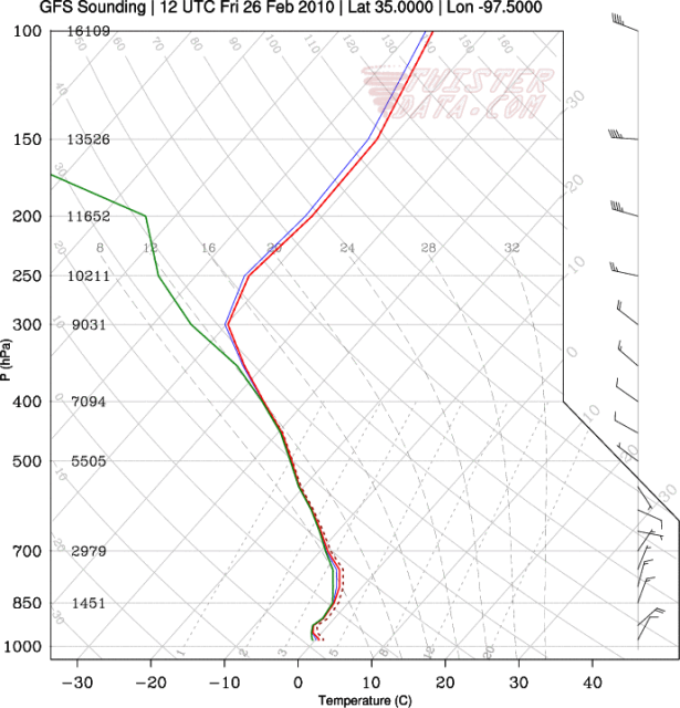
Skew-t for just south of OKC (hr 48) - http://i43.photobucket.com/albums/e371/ ... 975000.png
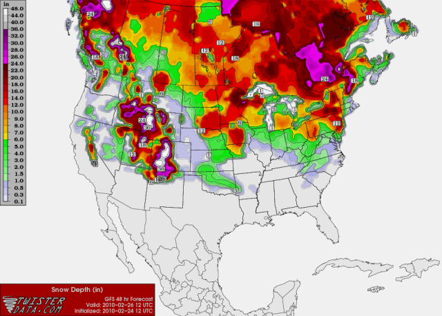
snow accumulation (hr 48) - http://i43.photobucket.com/albums/e371/ ... URFACE.png
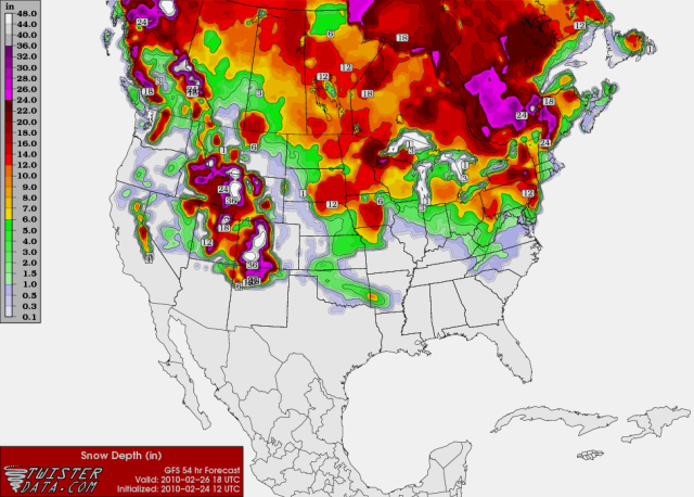
snow accumulation (hr 54) - http://i43.photobucket.com/albums/e371/ ... URFACE.png
SUNDAY/MONDAY SYSTEM:
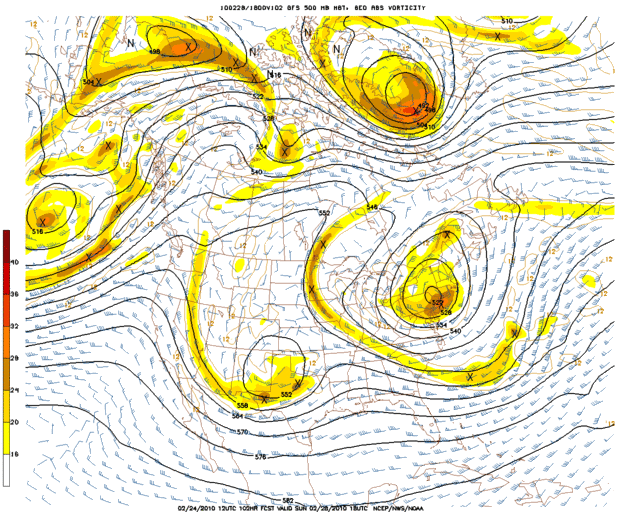
500mb chart (hr 102) - http://i43.photobucket.com/albums/e371/ ... 0_102l.gif
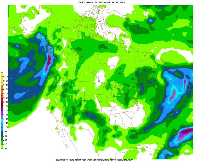
Total liquid equivalent precipitation - http://i43.photobucket.com/albums/e371/ ... 8_126l.gif
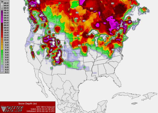
snow accumulation (hr 108) - http://i43.photobucket.com/albums/e371/ ... SURFAC.png
snow accumulation (hr 114) - http://i43.photobucket.com/albums/e371/ ... SURFAC.png
snow accumulation (hr 120) - http://i43.photobucket.com/albums/e371/ ... SURFAC.png
THURS NIGHT/FRIDAY SYSTEM:
Skew-t for just south of OKC (hr 48) - http://i43.photobucket.com/albums/e371/ ... 975000.png
snow accumulation (hr 48) - http://i43.photobucket.com/albums/e371/ ... URFACE.png
snow accumulation (hr 54) - http://i43.photobucket.com/albums/e371/ ... URFACE.png
SUNDAY/MONDAY SYSTEM:
500mb chart (hr 102) - http://i43.photobucket.com/albums/e371/ ... 0_102l.gif
Total liquid equivalent precipitation - http://i43.photobucket.com/albums/e371/ ... 8_126l.gif
snow accumulation (hr 108) - http://i43.photobucket.com/albums/e371/ ... SURFAC.png
snow accumulation (hr 114) - http://i43.photobucket.com/albums/e371/ ... SURFAC.png
snow accumulation (hr 120) - http://i43.photobucket.com/albums/e371/ ... SURFAC.png
0 likes
-
Extremeweatherguy
- Category 5
- Posts: 11095
- Joined: Mon Oct 10, 2005 8:13 pm
- Location: Houston, TX
Re: Southern Plains winter wx thread (2009-2010)
The 12z ECMWF is looking really good for snow in Oklahoma on Friday...even better than the GFS.
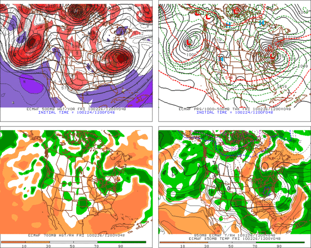
850mb temperatures below 0C, thicknesses below 540, and plenty of moisture to work with!
850mb temperatures below 0C, thicknesses below 540, and plenty of moisture to work with!
0 likes
-
Extremeweatherguy
- Category 5
- Posts: 11095
- Joined: Mon Oct 10, 2005 8:13 pm
- Location: Houston, TX

-
BlueIce
- S2K Supporter

- Posts: 194
- Age: 35
- Joined: Mon Sep 01, 2008 10:05 pm
- Location: Oklahoma City, Oklahoma
Re: Southern Plains winter wx thread (2009-2010)
Peanut432 wrote:GFS has almost killed the storm for Sunday
I agree looks like its calling for a dusting, maybe a little more.
0 likes
-
Extremeweatherguy
- Category 5
- Posts: 11095
- Joined: Mon Oct 10, 2005 8:13 pm
- Location: Houston, TX
There are still a lot of question marks surrounding the *potential* weekend/early week system. We probably will not have a real good handle on it until right before it happens because it will depend so much on how strong the ULL gets, the amount of cold air in place, and the exact track of the surface and upper level features. As of right now I could see it going either way...a big time storm or a bunch of nothing. We'll just have to wait and see how things trend.
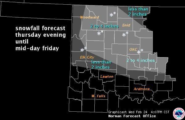
In the meantime though, it looks like we could have wintry problems to deal with in the much shorter term (next 24-48 hours). If the NWS forecast proves correct, then a good chunk of the state is in for an accumulating snowfall later this afternoon/evening through Friday morning/afternoon.
In the meantime though, it looks like we could have wintry problems to deal with in the much shorter term (next 24-48 hours). If the NWS forecast proves correct, then a good chunk of the state is in for an accumulating snowfall later this afternoon/evening through Friday morning/afternoon.
0 likes
-
msstateguy83
ok its quite apparent now the models are having quite a dificult time with this system for example
yesterday am it had wichita falls in about 0.40" of liquid precip for the time peroid we are talking about
then the last evening run went up to almost 1" now its giving me just less then 0.22" i just dont
think it has a good handle on the strength of the ull but time will tell....
yesterday am it had wichita falls in about 0.40" of liquid precip for the time peroid we are talking about
then the last evening run went up to almost 1" now its giving me just less then 0.22" i just dont
think it has a good handle on the strength of the ull but time will tell....
0 likes
-
Extremeweatherguy
- Category 5
- Posts: 11095
- Joined: Mon Oct 10, 2005 8:13 pm
- Location: Houston, TX
The morning NWS shift has decided to lower snowfall predictions a little bit..
It is worth noting that the bust potential with this forecast is unusually high though. This is a tricky forecast and several factors could lead to a change in the accumulation amounts. If temperatures at the surface are colder and more snow reaches ground level at a faster rate, then accumulations could be much higher. Conversely, if the surface is warmer and snow has a tougher time reaching the ground and accumulating, then accumulations could be less. For now I think the NWS forecast is a pretty good conservative approach to the system, but everyone should be aware that things could change quickly once the event actually begins and we see how things evolve.
It is worth noting that the bust potential with this forecast is unusually high though. This is a tricky forecast and several factors could lead to a change in the accumulation amounts. If temperatures at the surface are colder and more snow reaches ground level at a faster rate, then accumulations could be much higher. Conversely, if the surface is warmer and snow has a tougher time reaching the ground and accumulating, then accumulations could be less. For now I think the NWS forecast is a pretty good conservative approach to the system, but everyone should be aware that things could change quickly once the event actually begins and we see how things evolve.
0 likes
-
Extremeweatherguy
- Category 5
- Posts: 11095
- Joined: Mon Oct 10, 2005 8:13 pm
- Location: Houston, TX
URGENT - WINTER WEATHER MESSAGE
NATIONAL WEATHER SERVICE NORMAN OK
1130 AM CST THU FEB 25 2010
OKZ013-018>020-023>032-040>043-260500-
/O.NEW.KOUN.WW.Y.0011.100226T0600Z-100226T1800Z/
NOBLE-KINGFISHER-LOGAN-PAYNE-CADDO-CANADIAN-OKLAHOMA-LINCOLN-
GRADY-MCCLAIN-CLEVELAND-POTTAWATOMIE-SEMINOLE-HUGHES-GARVIN-
MURRAY-PONTOTOC-COAL-
INCLUDING THE CITIES OF...PERRY...KINGFISHER...GUTHRIE...
STILLWATER...ANADARKO...YUKON...EL RENO...MUSTANG...
OKLAHOMA CITY...CHANDLER...CHICKASHA...PURCELL...NORMAN...MOORE...
SHAWNEE...SEMINOLE...HOLDENVILLE...PAULS VALLEY...SULPHUR...ADA...
COALGATE
1130 AM CST THU FEB 25 2010
...WINTER WEATHER ADVISORY IN EFFECT FROM MIDNIGHT TONIGHT TO
NOON CST FRIDAY...
THE NATIONAL WEATHER SERVICE IN NORMAN HAS ISSUED A WINTER
WEATHER ADVISORY FOR SNOW... WHICH IS IN EFFECT FROM MIDNIGHT
TONIGHT TO NOON CST FRIDAY ACROSS PORTIONS OF CENTRAL AND SOUTHERN
OKLAHOMA.
* TIMING: FROM MIDNIGHT THROUGH FRIDAY MORNING
* MAIN IMPACT: SNOW ACCUMULATION UP TO 4 INCHES.
* OTHER IMPACTS: SNOW WILL PRIMARILY ACCUMULATE ON GRASSY
SURFACES. HOWEVER... SOME SNOW ACCUMULATION MAY OCCUR ON
ROADWAYS CAUSING SLUSHY AND SLICK CONDITIONS.
PRECAUTIONARY/PREPAREDNESS ACTIONS...
BE PREPARED FOR SLIPPERY ROADS AND LIMITED VISIBILITIES...AND USE
CAUTION WHILE DRIVING.
0 likes
-
Extremeweatherguy
- Category 5
- Posts: 11095
- Joined: Mon Oct 10, 2005 8:13 pm
- Location: Houston, TX
Re: Southern Plains winter wx thread (2009-2010)
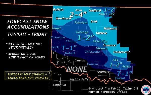
The NWS has upped thier expected snow totals again..
[img]--[/img]
[img]--[/img]
Last edited by Extremeweatherguy on Thu Feb 25, 2010 10:19 pm, edited 1 time in total.
0 likes
Based on what I can tell with the models, if there's a 4 inch total it would be from OKC and more likely to the southeast from maybe Ada to McAlester. Though temps there will be even more marginal so who knows.
0 likes
The above post and any post by Ntxw is NOT an official forecast and should not be used as such. It is just the opinion of the poster and may or may not be backed by sound meteorological data. It is NOT endorsed by any professional institution including Storm2k. For official information, please refer to NWS products.
Help support Storm2K!
Help support Storm2K!
-
Extremeweatherguy
- Category 5
- Posts: 11095
- Joined: Mon Oct 10, 2005 8:13 pm
- Location: Houston, TX
rain mixing with snow now on the south side of OKC. BIG flakes too. (90% rain/10% snow mix right now)
Update (1:26am) : Now more of a 40% rain/60% snow mix and the flakes are still huge! It is 36 degrees though, so the flakes are going to have a hard time sticking in the near term unless A) it cools further and/or B) It becomes 100% snow.
Update #2: And now its back to more rain than snow. It doesn't seem to want to make up its mind! lol
Oh well.. Off to bed..
Update #3: just woke up for a second and took a quick peak outside, and to my surprise it is now all snow and is accumulating fairly rapidly.
0 likes
-
Extremeweatherguy
- Category 5
- Posts: 11095
- Joined: Mon Oct 10, 2005 8:13 pm
- Location: Houston, TX
Well we wound up getting a nice little layer of snow overnight. With temperatures near/slightly above freezing, it is already starting to melt though and will probably be gone later today.
Overall this storm was definitely not as bad as it could have been. We stayed much closer to the 1" side of the estimates than we did to the 4" side.
Overall this storm was definitely not as bad as it could have been. We stayed much closer to the 1" side of the estimates than we did to the 4" side.
0 likes
-
Extremeweatherguy
- Category 5
- Posts: 11095
- Joined: Mon Oct 10, 2005 8:13 pm
- Location: Houston, TX
Looking ahead to Sunday/Monday..
It is looking less likely that we will see a big time storm around here. With marginal surface temperatures in place, it is probably going to be somewhat similar to today's event...may be slightly more snow in some places IF things can come together right. ATM, my prediction is for a scattered area of cold rain mixing with or changing to snow during the colder periods of the day across primarily the southern half of Oklahoma and extreme north Texas (where the most moisture and cold air will overlap). An inch or two of wet snow accumulation cannot be ruled out in the areas that manage to see a changeover.
Of course, being a couple of days out, changes are still possible. Stay tuned!
The following post is NOT an official forecast and should not be used as such. It is just the opinion of the poster and may or may not be backed by sound meteorological data. It is NOT endorsed by any professional institution including storm2k.org. For official information, please refer to NWS products.
0 likes
-
amawea

- S2K Supporter
- Posts: 385
- Age: 72
- Joined: Mon Aug 09, 2004 3:36 pm
- Location: Horseshoe Bend, Ar. but from Baytown, Tx
Re: Southern Plains winter wx thread (2009-2010)
Long Range out od Springfield is hinting at something by next weekend. Dry until then though.
0 likes
Re: Southern Plains winter wx thread (2009-2010)
A possible major winter storm is coming to the southern plains and this thread is quiet! Time to wake it up!
Winter storm watches for central and northern Oklahoma.
Winter storm watches for central and northern Oklahoma.
URGENT - WINTER WEATHER MESSAGE
NATIONAL WEATHER SERVICE NORMAN OK
320 PM CDT THU MAR 18 2010
OKZ004>031-190430-
/O.NEW.KOUN.WS.A.0003.100320T1200Z-100321T1200Z/
HARPER-WOODS-ALFALFA-GRANT-KAY-ELLIS-WOODWARD-MAJOR-GARFIELD-
NOBLE-ROGER MILLS-DEWEY-CUSTER-BLAINE-KINGFISHER-LOGAN-PAYNE-
BECKHAM-WASHITA-CADDO-CANADIAN-OKLAHOMA-LINCOLN-GRADY-MCCLAIN-
CLEVELAND-POTTAWATOMIE-SEMINOLE-
INCLUDING THE CITIES OF...BUFFALO...ALVA...CHEROKEE...MEDFORD...
PONCA CITY...ARNETT...WOODWARD...FAIRVIEW...ENID...PERRY...
CHEYENNE...TALOGA...WEATHERFORD...CLINTON...WATONGA...
KINGFISHER...GUTHRIE...STILLWATER...ELK CITY...SAYRE...CORDELL...
ANADARKO...YUKON...EL RENO...MUSTANG...OKLAHOMA CITY...CHANDLER...
CHICKASHA...PURCELL...NORMAN...MOORE...SHAWNEE...SEMINOLE
320 PM CDT THU MAR 18 2010
...WINTER STORM WATCH IN EFFECT FROM SATURDAY MORNING THROUGH
SUNDAY MORNING...
THE NATIONAL WEATHER SERVICE IN NORMAN HAS ISSUED A WINTER STORM
WATCH FROM SATURDAY MORNING THROUGH SUNDAY MORNING FOR HEAVY SNOW
ACROSS PORTIONS OF NORTHERN...WESTERN...AND CENTRAL OKLAHOMA.
* TIMING: EARLY SATURDAY MORNING THROUGH SUNDAY MORNING.
* MAIN IMPACT: HEAVY WET SNOWFALL REDUCING VISIBILITY AND
ACCUMULATING OVER 4 INCHES IN MANY AREAS...WITH LOCAL AMOUNTS
OVER 8 INCHES IN NORTHCENTRAL OKLAHOMA.
* OTHER IMPACTS: WIND GUSTS OVER 45 MPH WILL COMBINE WITH
TEMPERATURES JUST BELOW FREEZING TO PRODUCE WIND CHILLS IN THE
TEENS.
PRECAUTIONARY/PREPAREDNESS ACTIONS...
A WINTER STORM WATCH MEANS THERE IS A POTENTIAL FOR SIGNIFICANT
SNOW ACCUMULATIONS ALONG WITH STRONG WINDS THAT MAY IMPACT TRAVEL
AND STRESS LIVESTOCK. CONTINUE TO MONITOR THE LATEST FORECASTS.
0 likes
The above post and any post by Ntxw is NOT an official forecast and should not be used as such. It is just the opinion of the poster and may or may not be backed by sound meteorological data. It is NOT endorsed by any professional institution including Storm2k. For official information, please refer to NWS products.
Help support Storm2K!
Help support Storm2K!
-
BlueIce
- S2K Supporter
- Posts: 194
- Age: 35
- Joined: Mon Sep 01, 2008 10:05 pm
- Location: Oklahoma City, Oklahoma
Re: Southern Plains winter wx thread (2009-2010)
I meant to post on this earlier this week. Mike Morgan is calling big snow for Oklahoma we will see.
0 likes

Re:
Bryant44 wrote:Spring snowstorm coming tp OK. How much snow for OKC? Is this one of those Spring storms that could end up dumping a foot of snow in OKC metro area?
GFS has a widespread 3-6 inches around OKC metro locally 10+. The winds will be howling also, wouldn't be surprised if blizzard warnings were hoisted somewhere in Oklahoma. Blowing snow and visibility would be an issue with this storm.
0 likes
The above post and any post by Ntxw is NOT an official forecast and should not be used as such. It is just the opinion of the poster and may or may not be backed by sound meteorological data. It is NOT endorsed by any professional institution including Storm2k. For official information, please refer to NWS products.
Help support Storm2K!
Help support Storm2K!
Who is online
Users browsing this forum: No registered users and 79 guests