ATL: Ex-Tropical Storm HERMINE - Discussion
Moderator: S2k Moderators

Re: ATL: Tropical Storm HERMINE - Discussion
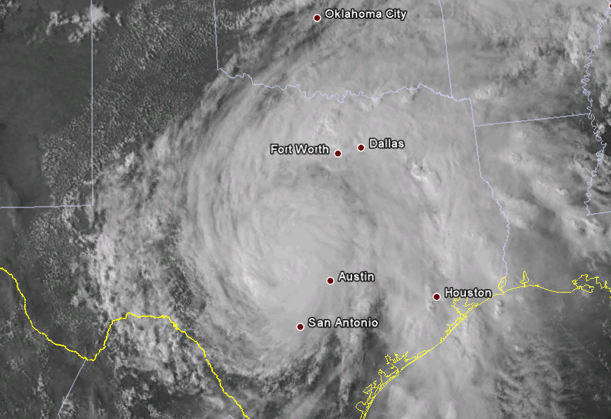
So Ive been following yall the past month with Dan, earl, gaston. I Thought things had settled down and have not watched tropics the past week and today I go to see why its raining and see that Hermine is coming to my house. lol.. Carrollton, tx
0 likes
-
hurrican19
- Tropical Storm

- Posts: 153
- Joined: Sun Jun 13, 2004 1:36 pm
- Location: Northwest Austin, TX
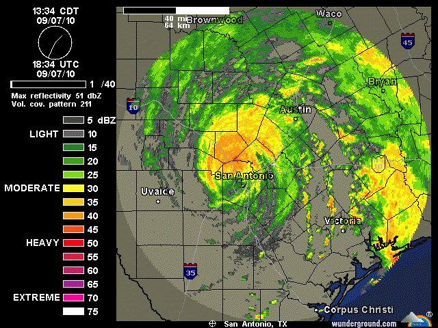
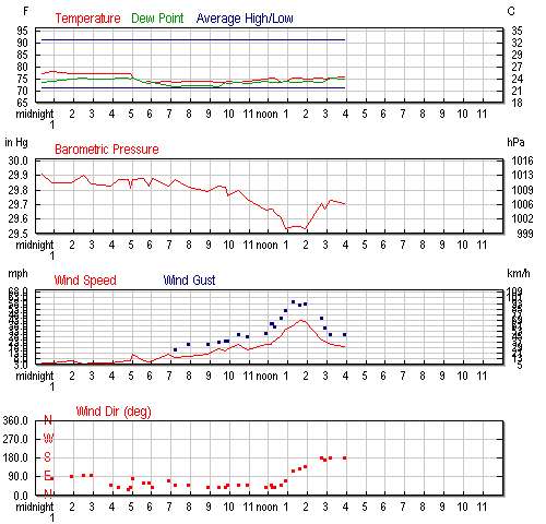
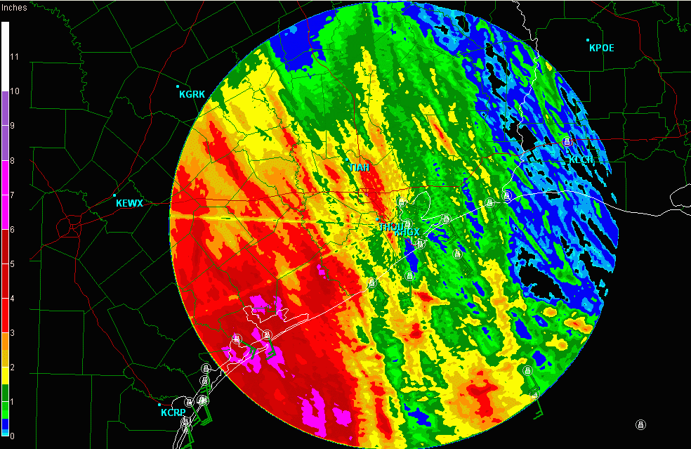
Not too sure how accurate the LCRA's wind guage is, but it's showing 48.5MPH Winds in 13 Miles WNW of Blanco (North of San Antonio/West of Austin). Doesn't specify if it's a Gust or sustained, but for the last 60 minutes have shown 25+MPH.
http://hydromet.lcra.org/recent.asp?Snu ... 2013%20WNW
http://hydromet.lcra.org/recent.asp?Snu ... 2013%20WNW
Last edited by hurrican19 on Tue Sep 07, 2010 3:51 pm, edited 2 times in total.
0 likes
-
CrazyC83
- Professional-Met

- Posts: 33398
- Joined: Tue Mar 07, 2006 11:57 pm
- Location: Deep South, for the first time!
Re:
hurrican19 wrote:Not too sure how accurate the LCRA's wind guage is, but it's showing 48.5MPH Winds in 13 Miles WNW of Blanco (North of San Antonio/West of Austin).
If that is accurate, a TCU would be needed to bump the intensity up to 45 kt.
EDIT: That would be sustained winds I believe.
0 likes


-
TwisterFanatic

- Category 5

- Posts: 1041
- Joined: Mon Jun 28, 2010 12:43 pm
- Location: Sallisaw, Oklahoma
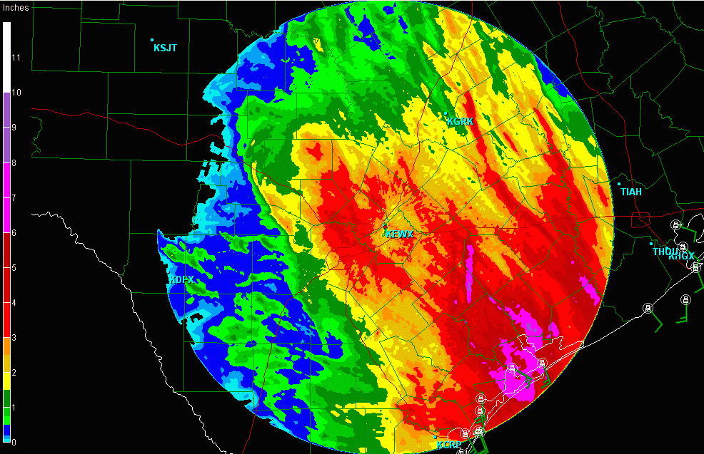
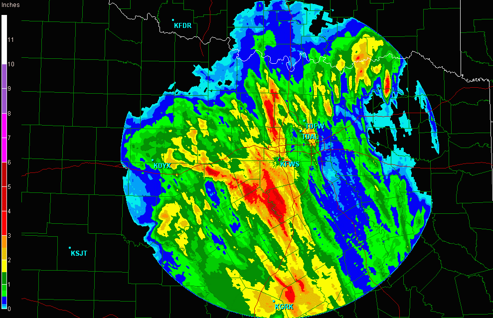
Here in Eastern Oklahoma i have picked up 3.54 inches of rain since about 1 PM. Due to a huge band of rain that set up over us. Could get a break over night and then the we are supposed to pick up another 5-6 inches tomorrow and tomorrow night. The NWS also saying tornadoes will be possible tomorrow also.
0 likes
Personal Forecast Disclaimer:
The posts in this forum are NOT official forecast and should not be used as such. They are just the opinion of the poster and may or may not be backed by sound meteorological data. They are NOT endorsed by any professional institution or storm2k.org. For official information, please refer to the NHC and NWS products.
The posts in this forum are NOT official forecast and should not be used as such. They are just the opinion of the poster and may or may not be backed by sound meteorological data. They are NOT endorsed by any professional institution or storm2k.org. For official information, please refer to the NHC and NWS products.
-
Dave

- Retired Staff

- Posts: 13442
- Age: 73
- Joined: Tue Aug 01, 2006 3:57 pm
- Location: Milan Indiana
- Contact:
BULLETIN - EAS ACTIVATION REQUESTED
FLASH FLOOD WARNING
NATIONAL WEATHER SERVICE AUSTIN/SAN ANTONIO TX
436 PM CDT TUE SEP 7 2010
THE NATIONAL WEATHER SERVICE IN AUSTIN SAN ANTONIO HAS ISSUED A
* FLASH FLOOD WARNING FOR...
NORTHERN BLANCO COUNTY...
WESTERN BURNET COUNTY...
EXTREME NORTHEASTERN GILLESPIE COUNTY...
LLANO COUNTY...
* UNTIL 730 PM CDT.
* AT 431 PM CDT...THE NATIONAL WEATHER SERVICE HAS DETERMINED THAT
RAINFALL ESTIMATES FROM DOPPLER RADAR INDICATE FLASH FLOODING FROM
TROPICAL STORM HERMINE OVER THE WARNED AREA.
* LOCATIONS IN THE WARNING INCLUDE BUT ARE NOT LIMITED TO LAKE
VICTOR...SMITHWICK...LONE GROVE...GAINESVILLE...STOLZ...BLUFFTON...
OXFORD...BABY HEAD...VALLEY SPRING...FIELD CREEK...PRAIRIE
MOUNTAIN...TOW...SUNRISE BEACH VILLAGE...MEADOWLAKES...MARBLE
FALLS...LLANO...KINGSLAND...INKS LAKE STATE PARK...HORSESHOE BAY...
GRANITE SHOALS...CASTELL...BURNET AND BUCHANAN DAM.
0 likes
-
Dave
- Retired Staff
- Posts: 13442
- Age: 73
- Joined: Tue Aug 01, 2006 3:57 pm
- Location: Milan Indiana
- Contact:
BULLETIN - EAS ACTIVATION REQUESTED
TORNADO WARNING
NATIONAL WEATHER SERVICE AUSTIN/SAN ANTONIO TX
442 PM CDT TUE SEP 7 2010
THE NATIONAL WEATHER SERVICE IN AUSTIN SAN ANTONIO HAS ISSUED A
* TORNADO WARNING FOR...
NORTH CENTRAL DEWITT COUNTY...
* UNTIL 515 PM CDT.
* AT 441 PM CDT...NWS METEOROLOGISTS HAVE DETECTED A SEVERE
THUNDERSTORM CAPABLE OF PRODUCING A TORNADO IN CUERO...MOVING
NORTH AT 30 MPH.
* SOME LOCATIONS IN THE WARNING INCLUDE HOCHHEIM.
0 likes
-
tolakram
- Admin

- Posts: 19182
- Age: 60
- Joined: Sun Aug 27, 2006 8:23 pm
- Location: Florence, KY (name is Mark)
Re: ATL: Tropical Storm HERMINE - Discussion
saved radar loop
San Antonio KSAT
San Antonio KSAT
0 likes
M a r k
- - - - -
Join us in chat: Storm2K Chatroom Invite. Android and IOS apps also available.
The posts in this forum are NOT official forecasts and should not be used as such. Posts are NOT endorsed by any professional institution or STORM2K.org. For official information and forecasts, please refer to NHC and NWS products.

-
fasterdisaster
- Category 5
- Posts: 1868
- Joined: Mon Sep 19, 2005 4:41 pm
- Location: Miami, Florida
-
Wthrman13

- Professional-Met
- Posts: 502
- Joined: Sun Jul 06, 2003 12:44 pm
- Location: West Lafayette, IN
- Contact:
Re:
fasterdisaster wrote:I'm astonished by how good Hermine looks after 18 hours on land. I definitely think 60 mph was too low an estimate for the landfall intensity.
Just wait until it gets into Oklahoma
Seriously, though, I do expect a bunch of rain, and possibly some low-topped supercells; I might go chasing if things look good tomorrow
0 likes

Re: ATL: Tropical Depression HERMINE - Discussion
I've had enough flooded roadways, hydroplaning, and tornadoes this afternoon!!!!!!!!!!!!!!!!!!!!! I still love it though...... 

0 likes
-
Stephanie

- S2K Supporter

- Posts: 23842
- Age: 61
- Joined: Thu Feb 06, 2003 9:53 am
- Location: Glassboro, NJ
Re: ATL: Tropical Depression HERMINE - Discussion
Take care everyone in TX. I wish you could share some of your rain with us. Earl forgot to leave us any... 
0 likes
-
Portastorm

- Storm2k Moderator

- Posts: 9787
- Age: 61
- Joined: Fri Jul 11, 2003 9:16 am
- Location: South Austin, TX
- Contact:
Re: ATL: Tropical Depression HERMINE - Discussion
Interesting evening here in the capital of Texas ... two tornado warnings in the last hour. Both were from radar signatures though and no sightings on the ground that I heard of.
0 likes
Who is online
Users browsing this forum: No registered users and 8 guests