ATL: DON - Remnant - Discussion

Moderator: S2k Moderators

Message
Author
djmikey
Tropical Storm
Tropical Storm
Posts: 153
Joined: Tue Jul 20, 2010 6:04 pm
Location: Beaumont, TX

Re: ATL: DON - Tropical Storm - Discussion

#3101 Postby djmikey » Thu Jul 28, 2011 8:51 pm

lebron23 wrote:AccuWeather's rainfall estimates...
http://sirocco.accuweather.com/adc_hurr ... 40x480.gif

Booo... :cry:
0 likes   

User avatar
South Texas Storms
Professional-Met
Professional-Met
Posts: 4202
Joined: Thu Jun 24, 2010 12:28 am
Location: Houston, TX

Re: ATL: DON - Models

#3102 Postby South Texas Storms » Thu Jul 28, 2011 8:52 pm

What did the 5am track from this morning show?
0 likes   

ozonepete
Professional-Met
Professional-Met
Posts: 4743
Joined: Mon Sep 07, 2009 3:23 pm
Location: From Ozone Park, NYC / Now in Brooklyn, NY

Re: ATL: DON - Tropical Storm - Discussion

#3103 Postby ozonepete » Thu Jul 28, 2011 8:52 pm

CypressMike wrote: In his Weatherbell blog he's been saying since yesterday that this would be at or near Cat 1 strength upon landfall. In his latest blog he says it could wind up being a bit stronger than he originally thought, and is confident it will be a cane by landfall.
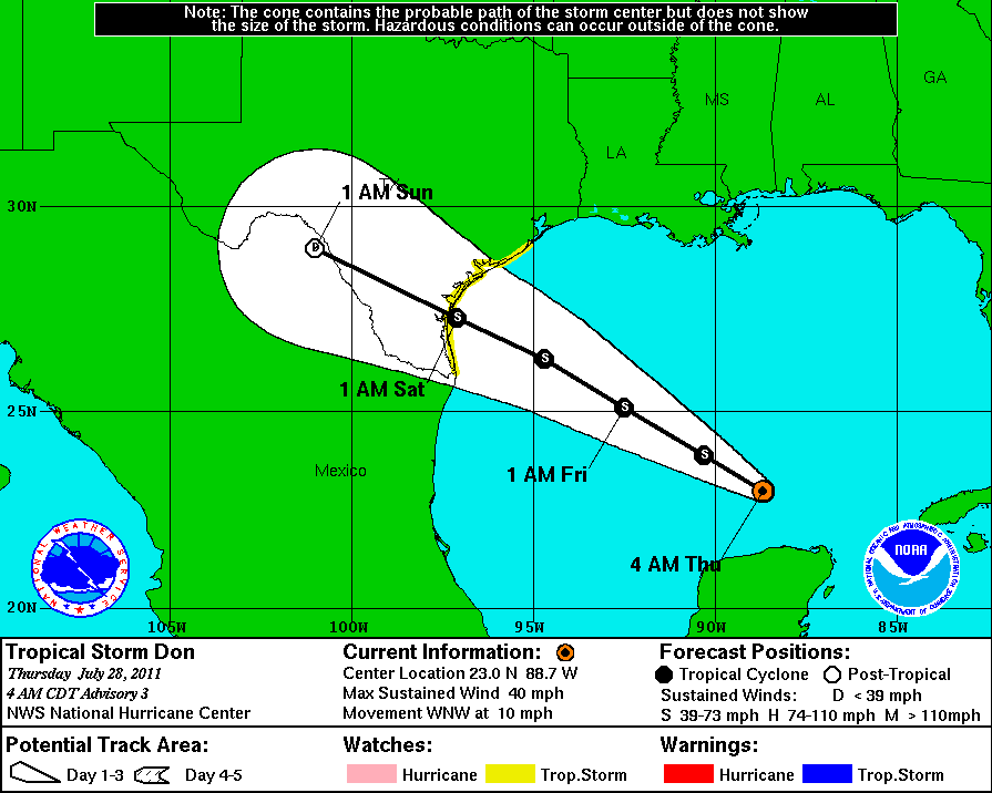

Not saying anything more or less, but the pro mets here have a MUCH better record on tropical cyclone forecasting than he does. They have studied hurricane forecasting and have degrees in it.
0 likes   

User avatar
gatorcane
S2K Supporter
S2K Supporter
Posts: 23689
Age: 47
Joined: Sun Mar 13, 2005 3:54 pm
Location: Boca Raton, FL

Re: Re:

#3104 Postby gatorcane » Thu Jul 28, 2011 8:53 pm

South Texas Storms wrote:
gatorcane wrote:
CrazyC83 wrote:Of course Celia bombed out in that region too - any chance this could do so in the next 24 hours?


None of the guidance suggest this.

In fact the ECMWF/GFDL/HWRF all suggest some slight strengthening over the next 12 hours followed by noticeable weakening as it approaches the coast.

For example, look at the HWRF. Look how it weakens it when it is about 12 hours away from landfall.

http://moe.met.fsu.edu/cgi-bin/hwrftc2. ... =Animation


That weakening would bring it slightly more northward right?


Quite possibly. Look here at the 18Z GFS at 18 hours. If we look at the 700MB flow for a shallow system (lower in the atmosphere), we see the wind flow is more SE to NW in the Western GOM:

Image

Let's say the system was a very deep system. We will look more at the 200MB to 500MB flow, higher up in the atmosphere. Look at the 300MB flow for example. You can see it is more East to West:

Image
0 likes   

User avatar
Dave
Retired Staff
Retired Staff
Posts: 13442
Age: 74
Joined: Tue Aug 01, 2006 3:57 pm
Location: Milan Indiana
Contact:

#3105 Postby Dave » Thu Jul 28, 2011 8:53 pm

443
URNT15 KNHC 290151
AF307 0404A DON HDOB 25 20110729
014200 2406N 09135W 8428 01569 0086 +176 +167 189020 020 030 001 00
014230 2407N 09136W 8429 01567 0086 +175 +171 192025 026 032 000 00
014300 2409N 09137W 8431 01565 0086 +175 +173 190025 027 032 000 00
014330 2410N 09139W 8430 01565 0087 +176 +176 191022 024 034 004 00
014400 2411N 09140W 8431 01564 0085 +179 +177 193019 022 035 004 00
014430 2412N 09141W 8425 01574 0086 +165 //// 208018 021 035 008 01
014500 2413N 09143W 8427 01568 //// +166 //// 216018 018 038 004 01
014530 2415N 09144W 8429 01563 0085 +171 //// 206014 015 039 004 01
014600 2416N 09145W 8430 01564 0082 +180 //// 215020 022 039 003 01
014630 2417N 09147W 8431 01562 0079 +181 //// 216017 019 038 001 01
014700 2418N 09148W 8432 01562 0079 +182 +180 213019 020 037 004 00
014730 2419N 09149W 8429 01563 0082 +175 //// 209019 020 037 004 01
014800 2421N 09150W 8429 01562 0078 +183 +166 214018 018 038 004 00
014830 2422N 09152W 8432 01557 0075 +185 +161 211019 020 039 002 00
014900 2423N 09153W 8429 01559 0072 +188 +159 200021 022 029 001 00
014930 2424N 09154W 8428 01561 0071 +186 +159 201023 024 029 000 00
015000 2426N 09156W 8433 01551 0066 +187 +172 206022 022 029 000 03
015030 2427N 09157W 8429 01551 0061 +186 +185 207022 023 029 001 00
015100 2428N 09158W 8429 01550 0059 +184 //// 204023 027 029 003 05
015130 2429N 09200W 8433 01541 0052 +191 +175 202025 025 030 001 00
$$
;
0 likes   

lebron23
Category 1
Category 1
Posts: 389
Age: 31
Joined: Sat May 24, 2008 11:58 am
Contact:

Re: ATL: DON - Models

#3106 Postby lebron23 » Thu Jul 28, 2011 8:54 pm

0 likes   

ozonepete
Professional-Met
Professional-Met
Posts: 4743
Joined: Mon Sep 07, 2009 3:23 pm
Location: From Ozone Park, NYC / Now in Brooklyn, NY

Re: ATL: DON - Tropical Storm - Discussion

#3107 Postby ozonepete » Thu Jul 28, 2011 8:54 pm

"Little" Don ain't so little any more. That's a lot of PWAT and a LOT of area.
0 likes   

User avatar
HURAKAN
Professional-Met
Professional-Met
Posts: 46086
Age: 38
Joined: Thu May 20, 2004 4:34 pm
Location: Key West, FL
Contact:

#3108 Postby HURAKAN » Thu Jul 28, 2011 8:56 pm

Image
0 likes   

User avatar
Ptarmigan
Category 5
Category 5
Posts: 5313
Joined: Wed Aug 16, 2006 9:06 pm

Re:

#3109 Postby Ptarmigan » Thu Jul 28, 2011 8:56 pm

CrazyC83 wrote:Of course Celia bombed out in that region too - any chance this could do so in the next 24 hours?


Anything is possible.
0 likes   

SunnyThoughts
Category 5
Category 5
Posts: 2263
Joined: Wed Jul 09, 2003 12:42 pm
Location: Pensacola, Florida

Re: ATL: DON - Tropical Storm - Discussion

#3110 Postby SunnyThoughts » Thu Jul 28, 2011 8:59 pm

Water Vapor imagery

Image
0 likes   

lebron23
Category 1
Category 1
Posts: 389
Age: 31
Joined: Sat May 24, 2008 11:58 am
Contact:

#3111 Postby lebron23 » Thu Jul 28, 2011 8:59 pm

If this model runs pan out then I think that Houston will see a least a few feeder bands, to the south and west mainly

http://euler.atmos.colostate.edu/~vigh/ ... early1.png
0 likes   

User avatar
Swimdude
Category 5
Category 5
Posts: 2270
Joined: Mon Jul 26, 2004 11:57 am
Location: Houston, TX

Re:

#3112 Postby Swimdude » Thu Jul 28, 2011 9:02 pm

lebron23 wrote:If this model runs pan out then I think that Houston will see a least a few feeder bands, to the south and west mainly

http://euler.atmos.colostate.edu/~vigh/ ... early1.png


I've said it before and I'll say it again--you never know what happens until landfall. Like I said yesterday, check out this landfall loop of Dolly. I don't think many people expected Houston to get significant rainfall from Dolly, but look what happened during the two days AFTER landfall.

http://www.wunderground.com/hurricane/a ... ture=radar
0 likes   

User avatar
Dave
Retired Staff
Retired Staff
Posts: 13442
Age: 74
Joined: Tue Aug 01, 2006 3:57 pm
Location: Milan Indiana
Contact:

#3113 Postby Dave » Thu Jul 28, 2011 9:04 pm

649
URNT15 KNHC 290201
AF307 0404A DON HDOB 26 20110729
015200 2430N 09201W 8428 01542 0045 +195 +189 208023 024 027 003 00
015230 2432N 09202W 8429 01535 0034 +200 //// 202025 025 032 001 01
015300 2433N 09204W 8430 01525 0012 +225 +177 179023 025 034 003 03
015330 2433N 09206W 8428 01525 9995 +256 +152 155015 021 029 002 03
015400 2433N 09207W 8434 01519 9997 +252 +161 239005 008 037 001 03
015430 2433N 09209W 8431 01525 0015 +215 +196 314016 019 036 004 03
015500 2434N 09210W 8429 01528 0020 +210 +193 350017 019 038 003 00
015530 2434N 09210W 8429 01528 0018 +223 +176 023025 029 036 003 00
015600 2436N 09213W 8429 01533 0022 +219 +175 035028 029 033 003 00
015630 2437N 09214W 8433 01533 0028 +218 +170 041032 032 033 001 00
015700 2438N 09215W 8429 01540 0034 +212 +175 042033 033 032 002 00
015730 2439N 09217W 8434 01538 0041 +213 +163 041031 032 029 001 00
015800 2440N 09218W 8426 01550 0045 +208 +162 042029 030 027 001 00
015830 2442N 09219W 8433 01545 0048 +210 +158 044030 031 026 000 00
015900 2443N 09220W 8430 01551 0053 +207 +155 049029 030 027 001 00
015930 2444N 09222W 8430 01553 0054 +210 +154 057030 031 024 000 00
020000 2445N 09223W 8429 01557 0060 +207 +160 064029 031 024 001 00
020030 2446N 09224W 8432 01557 0063 +201 +163 066026 027 025 001 00
020100 2448N 09226W 8428 01561 0066 +198 +163 069026 026 024 002 00
020130 2449N 09227W 8433 01557 0068 +197 +169 066025 026 025 001 00
$$
;
0 likes   

lebron23
Category 1
Category 1
Posts: 389
Age: 31
Joined: Sat May 24, 2008 11:58 am
Contact:

Re: Re:

#3114 Postby lebron23 » Thu Jul 28, 2011 9:04 pm

Swimdude wrote:
lebron23 wrote:If this model runs pan out then I think that Houston will see a least a few feeder bands, to the south and west mainly

http://euler.atmos.colostate.edu/~vigh/ ... early1.png


I've said it before and I'll say it again--you never know what happens until landfall. Like I said yesterday, check out this landfall loop of Dolly. I don't think many people expected Houston to get significant rainfall from Dolly, but look what happened during the two days AFTER landfall.

http://www.wunderground.com/hurricane/a ... ture=radar


Wow and dolly was a small hurricane
0 likes   

User avatar
jasons2k
Storm2k Executive
Storm2k Executive
Posts: 8242
Age: 51
Joined: Wed Jul 06, 2005 12:32 pm
Location: The Woodlands, TX

#3115 Postby jasons2k » Thu Jul 28, 2011 9:06 pm

I'm just not optimistic at all for any significant rainfall in the Houston area. I think that was pretty clear yesterday, and after today, pretty much any hope I was holding-out for has evaporated.

I do notice some dry air on the CIMSS WV loop is getting entrained into the circulation. Prob will keep Don in check.
0 likes   

User avatar
HURAKAN
Professional-Met
Professional-Met
Posts: 46086
Age: 38
Joined: Thu May 20, 2004 4:34 pm
Location: Key West, FL
Contact:

#3116 Postby HURAKAN » Thu Jul 28, 2011 9:06 pm

Image
0 likes   

User avatar
Swimdude
Category 5
Category 5
Posts: 2270
Joined: Mon Jul 26, 2004 11:57 am
Location: Houston, TX

Re:

#3117 Postby Swimdude » Thu Jul 28, 2011 9:09 pm

jasons wrote:I'm just not optimistic at all for any significant rainfall in the Houston area. I think that was pretty clear yesterday, and after today, pretty much any hope I was holding-out for has evaporated.

I do notice some dry air on the CIMSS WV loop is getting entrained into the circulation. Prob will keep Don in check.


Well... I suppose the best I can do is hope that your pessimism is wrong. :lol: Although frankly anywhere in Texas can use the rain--I just happen to have first-hand experience with the drought conditions in Houston.
0 likes   

User avatar
Dave
Retired Staff
Retired Staff
Posts: 13442
Age: 74
Joined: Tue Aug 01, 2006 3:57 pm
Location: Milan Indiana
Contact:

#3118 Postby Dave » Thu Jul 28, 2011 9:14 pm

968
URNT15 KNHC 290212
AF307 0404A DON HDOB 27 20110729
020200 2450N 09228W 8430 01561 0070 +190 +181 065024 025 024 002 00
020230 2451N 09230W 8428 01564 0072 +190 +188 067024 025 027 003 00
020300 2453N 09231W 8429 01563 0075 +190 +171 070024 024 022 001 00
020330 2454N 09232W 8430 01564 0075 +191 +171 073024 025 021 001 00
020400 2455N 09234W 8432 01563 0077 +192 +171 075026 027 020 001 00
020430 2456N 09235W 8430 01568 0081 +188 +177 067025 026 021 000 00
020500 2458N 09236W 8429 01568 0081 +188 +175 065024 024 021 001 00
020530 2459N 09238W 8429 01569 0080 +193 +159 062025 025 021 002 00
020600 2500N 09239W 8429 01570 0084 +189 +158 061024 024 025 001 00
020630 2501N 09240W 8429 01569 0081 +195 +153 060024 025 023 003 00
020700 2502N 09242W 8430 01572 0079 +200 +150 059023 024 021 001 00
020730 2504N 09243W 8429 01573 0083 +196 +153 062023 024 023 000 00
020800 2505N 09244W 8429 01573 0083 +195 +154 062021 022 022 002 00
020830 2506N 09246W 8432 01570 0084 +195 +153 060020 021 021 001 00
020900 2507N 09247W 8430 01570 0085 +191 +154 056023 024 023 002 00
020930 2509N 09248W 8429 01573 0084 +194 +153 060024 024 021 001 00
021000 2510N 09250W 8429 01572 0083 +196 +151 062024 025 022 001 00
021030 2511N 09251W 8430 01570 0082 +198 +149 064024 025 021 001 00
021100 2512N 09252W 8429 01573 0083 +195 +151 065024 024 021 001 00
021130 2513N 09254W 8430 01573 0085 +194 +158 067024 024 022 000 00
$$
;
0 likes   

User avatar
HURAKAN
Professional-Met
Professional-Met
Posts: 46086
Age: 38
Joined: Thu May 20, 2004 4:34 pm
Location: Key West, FL
Contact:

#3119 Postby HURAKAN » Thu Jul 28, 2011 9:15 pm

Image
0 likes   

User avatar
Annie Oakley
Category 5
Category 5
Posts: 1103
Joined: Tue Jul 31, 2007 12:54 pm
Location: Texas

#3120 Postby Annie Oakley » Thu Jul 28, 2011 9:19 pm

Recon thread showing 9995
go look

viewtopic.php?f=59&t=111254&start=240
0 likes   


Return to “2011”

Who is online

Users browsing this forum: No registered users and 70 guests