ATL: INVEST 95L - Discussion
Moderator: S2k Moderators

Intense convection firing this moring just SSE of Cozumel...pressures and winds would support TD if not TS status. However, at this hour still broad without a well defined center per obs/ship reports. Expect by this evening a more pronounced surface circulation with the sustained convection ongoing now and favorable upper-air environment. Probablly an upgrade overnight..
0 likes

-
northjaxpro

- S2K Supporter

- Posts: 8900
- Joined: Mon Sep 27, 2010 11:21 am
- Location: Jacksonville, FL
Re:
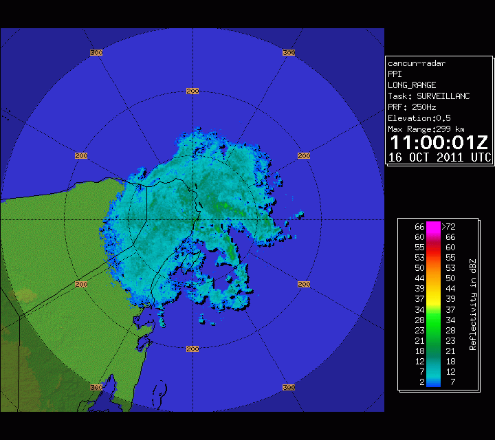
NDG wrote:Cancun radar loop, looks to me that the COC is near Cozumel just to the SSE.
Yep! I would estimate the Low center just south of Cozumel. Literally, the Low center will be moving over Cozumel shortly. The Low should be fully emerging into the extreme Southern GOM by tonight.
0 likes
NEVER, EVER SAY NEVER in the tropics and weather in general, and most importantly, with life itself!!
________________________________________________________________________________________
Fay 2008 Beryl 2012 Debby 2012 Colin 2016 Hermine 2016 Julia 2016 Matthew 2016 Irma 2017 Dorian 2019
________________________________________________________________________________________
Fay 2008 Beryl 2012 Debby 2012 Colin 2016 Hermine 2016 Julia 2016 Matthew 2016 Irma 2017 Dorian 2019
-
Rainband
Re: ATL: INVEST 95L - Discussion
cycloneye wrote:Rainband wrote:The following post is NOT an official forecast and should not be used as such. It is just the opinion of the poster and may or may not be backed by sound meteorological data. It is NOT endorsed by any professional institution including storm2k.org. For Official Information please refer to the NHC and NWS products.
I think that watches and warnings will be up today. I think this is already a TS and will become a Hurricane. This is my opinion and not backed by anything other than that
Hi Johnnathan. I had to put the S2K disclaimer.
Thanks Luis
0 likes


Re: Re:
northjaxpro wrote:NDG wrote:Cancun radar loop, looks to me that the COC is near Cozumel just to the SSE.
Yep! I would estimate the Low center just south of Cozumel. Literally, the Low center will be moving over Cozumel shortly. The Low should be fully emerging into the extreme Southern GOM by tonight.
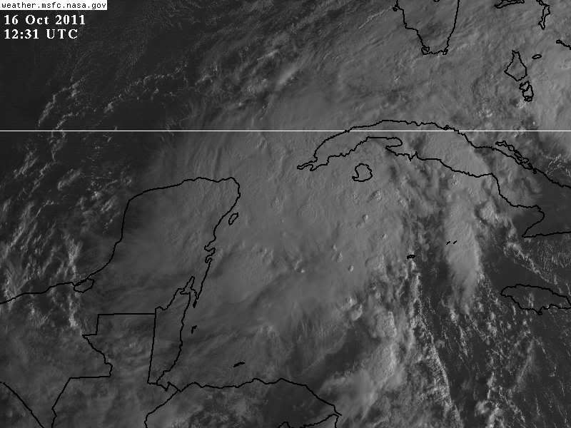
12:15 vis also supports location...over or just south of cozumel.
http://www.ghcc.msfc.nasa.gov/cgi-bin/post-goes
0 likes
-
Rainband
Re: ATL: INVEST 95L - Discussion
I would say the eastern part of cuba and the yucatan and depending on the speed and organization prolly the keys??? The posts in this forum are NOT official forecast and should not be used as such. They are just the opinion of the poster and may or may not be backed by sound meteorological data. They are NOT endorsed by any professional institution or storm2k.org. For official information, please refer to the NHC and NWS productswzrgirl1 wrote:Watches and warnings where rainband???
0 likes
-
cycloneye

- Admin

- Posts: 139027
- Age: 67
- Joined: Thu Oct 10, 2002 10:54 am
- Location: San Juan, Puerto Rico
Re: ATL: INVEST 95L - Discussion
12z Best Track
AL, 95, 2011101612, , BEST, 0, 194N, 879W, 30, 1004, LO
ftp://ftp.tpc.ncep.noaa.gov/atcf/tcweb/ ... 011.invest
AL, 95, 2011101612, , BEST, 0, 194N, 879W, 30, 1004, LO
ftp://ftp.tpc.ncep.noaa.gov/atcf/tcweb/ ... 011.invest
0 likes
Visit the Caribbean-Central America Weather Thread where you can find at first post web cams,radars
and observations from Caribbean basin members Click Here
and observations from Caribbean basin members Click Here
-
SFLcane

- S2K Supporter
- Posts: 9606
- Age: 46
- Joined: Sat Jun 05, 2010 1:44 pm
- Location: Lake Worth Florida
Re: ATL: INVEST 95L - Discussion
From Crown Weather this morning...http://www.crownweather.com/?page_id=4557
Additionally, closer analysis using the CIMSS products reveals that this low pressure system may be redeveloping further east near 20 North Latitude, 85 West Longitude as low level convergence and vorticity is definitely increasing in this area. Buoy reports also indicate that pressures are falling in this general area and indeed a new low pressure system may be forming very near 19.8 North Latitude and 84.9 West Longitude. Should this indeed happen, then I think we will see a tropical storm develop in the far northwestern Caribbean just east of the eastern Yucatan Peninsula as early as late today or tonight.
Additionally:
Everyone across the southern half of Florida and the Florida Keys should keep very close tabs on the progress of this storm and do not be surprised to see this upgraded to a tropical storm with Tropical Storm Watches going up as early as Monday.
0 likes
-
SFLcane
- S2K Supporter
- Posts: 9606
- Age: 46
- Joined: Sat Jun 05, 2010 1:44 pm
- Location: Lake Worth Florida
Re: ATL: INVEST 95L - Discussion
Most models shear this thing out or bury it in the yucatan as frontal boundary moves into the gulf next week.
0 likes
-
Rainband
Re: ATL: INVEST 95L - Discussion
right near the buoy I postedSFLcane wrote:From Crown Weather this morning...http://www.crownweather.com/?page_id=4557
Additionally, closer analysis using the CIMSS products reveals that this low pressure system may be redeveloping further east near 20 North Latitude, 85 West Longitude as low level convergence and vorticity is definitely increasing in this area. Buoy reports also indicate that pressures are falling in this general area and indeed a new low pressure system may be forming very near 19.8 North Latitude and 84.9 West Longitude. Should this indeed happen, then I think we will see a tropical storm develop in the far northwestern Caribbean just east of the eastern Yucatan Peninsula as early as late today or tonight.
Additionally:
Everyone across the southern half of Florida and the Florida Keys should keep very close tabs on the progress of this storm and do not be surprised to see this upgraded to a tropical storm with Tropical Storm Watches going up as early as Monday.
0 likes

Re: ATL: INVEST 95L - Discussion
SFLcane wrote:Most models shear this thing out or bury it in the yucatan as frontal boundary moves into the gulf next week.
Yeah, that's what they said about Wilma too, LOL. Now, I'm certainly not comparing future Rina to that intensity, but this system will be traveling in the direction of the shear (uni-directional). Shear will be strongest the further north it travels in the GOM. No doubt it'll be sheared if reaches 28N and beyond, but even sheared systems can maintain TS strength which can cause torrential rain, winds, and possible tornadoes.
Not sure most models had the center so far north off the NE tip of the Yucatan. This new low center may change the models.
Last edited by ronjon on Sun Oct 16, 2011 8:09 am, edited 1 time in total.
0 likes
Re: ATL: INVEST 95L - Discussion
When do you think is the soonest a plane will go in there, today or tomorrow?
0 likes
-
caneman
Re: ATL: INVEST 95L - Discussion
SFLcane wrote:Most models shear this thing out or bury it in the yucatan as frontal boundary moves into the gulf next week.
I wouldn't be paying any mind to models right now. Thus far, it hasn't acted according to them or the NHC. It's close enough to land now to where I'll just satellite watch. Wouldn't be surprised to see this get up to 60 or 70. Further, I keep seeing people talk about sheared out. Please remember folks, a system doesn't just get sheared out automatically. It will be close enough to Florida to where it won't have that much time to weaken, further it will be moving with the wind the flow. Living in West Florida for soooo many years we've seen many systems like this, this time of year to get a feel for how they behave.
0 likes
Re: ATL: INVEST 95L - Discussion
Rainband wrote:right near the buoy I postedSFLcane wrote:From Crown Weather this morning...http://www.crownweather.com/?page_id=4557
Additionally, closer analysis using the CIMSS products reveals that this low pressure system may be redeveloping further east near 20 North Latitude, 85 West Longitude as low level convergence and vorticity is definitely increasing in this area. Buoy reports also indicate that pressures are falling in this general area and indeed a new low pressure system may be forming very near 19.8 North Latitude and 84.9 West Longitude. Should this indeed happen, then I think we will see a tropical storm develop in the far northwestern Caribbean just east of the eastern Yucatan Peninsula as early as late today or tonight.
Additionally:
Everyone across the southern half of Florida and the Florida Keys should keep very close tabs on the progress of this storm and do not be surprised to see this upgraded to a tropical storm with Tropical Storm Watches going up as early as Monday.
Pretty stiff straight south winds reported by the buoy, so the COC is definitely not right on top of the buoy, instead of near 85W I would say between 86-87W longitude is where I think the COC is.
0 likes
-
SeminoleWind

- Category 1

- Posts: 359
- Age: 49
- Joined: Wed Jun 02, 2010 8:37 pm
- Location: Lake County Florida

0 likes
This post is NOT an official forecast and should not be used as such. It is just the opinion of the poster and may or may not be backed by sound meteorological data. It is NOT endorsed by any professional institution including storm2k.org For Official Information please refer to the NHC and NWS products.
-
SFLcane
- S2K Supporter
- Posts: 9606
- Age: 46
- Joined: Sat Jun 05, 2010 1:44 pm
- Location: Lake Worth Florida
Re: ATL: INVEST 95L - Discussion
ronjon wrote:SFLcane wrote:Most models shear this thing out or bury it in the yucatan as frontal boundary moves into the gulf next week.
Yeah, that's what they said about Wilma too, LOL. Now, I'm certainly not comparing future Rina to that intensity, but this system will be traveling in the direction of the shear (uni-directional). Shear will be strongest the further north it travels in the GOM. No doubt it'll be sheared if reaches 28N and beyond, but even sheared systems can maintain TS strength which can cause torrential rain, winds, and possible tornadoes.
Not sure most models had the center so far north off the NE tip of the Yucatan. This new low center may change the models.
TPC has the low still inland. The current thinking is not even remotely close to wilma. Both GFS/ECM entrain what ever is left of the low into the frontal boundary next week enhanceing rainfall over SFL.

0 likes
Who is online
Users browsing this forum: No registered users and 59 guests