hmmm the nam.... the euro had a similar idea the other day about some sort of a vort develop to its west and had made sandy do a hard left.
http://mag.ncep.noaa.gov/NCOMAGWEB/appc ... mageSize=M
very strange though.
ATL: SANDY - Models
Moderator: S2k Moderators
-
Aric Dunn
- Category 5

- Posts: 21228
- Age: 41
- Joined: Sun Sep 19, 2004 9:58 pm
- Location: Ready for the Chase.
- Contact:
0 likes
Note: If I make a post that is brief. Please refer back to previous posts for the analysis or reasoning. I do not re-write/qoute what my initial post said each time.
If there is nothing before... then just ask
Space & Atmospheric Physicist, Embry-Riddle Aeronautical University,
I believe the sky is falling...
If there is nothing before... then just ask
Space & Atmospheric Physicist, Embry-Riddle Aeronautical University,
I believe the sky is falling...
-
Aric Dunn
- Category 5
- Posts: 21228
- Age: 41
- Joined: Sun Sep 19, 2004 9:58 pm
- Location: Ready for the Chase.
- Contact:
seriously sometimes you just have to love the NAM.. lol
http://mag.ncep.noaa.gov/NCOMAGWEB/appc ... mageSize=M
http://mag.ncep.noaa.gov/NCOMAGWEB/appc ... mageSize=M
0 likes
Note: If I make a post that is brief. Please refer back to previous posts for the analysis or reasoning. I do not re-write/qoute what my initial post said each time.
If there is nothing before... then just ask
Space & Atmospheric Physicist, Embry-Riddle Aeronautical University,
I believe the sky is falling...
If there is nothing before... then just ask
Space & Atmospheric Physicist, Embry-Riddle Aeronautical University,
I believe the sky is falling...
-
Bocadude85

- Category 5
- Posts: 2941
- Age: 37
- Joined: Mon Apr 18, 2005 2:20 pm
- Location: Honolulu,Hi
Re:
Aric Dunn wrote:seriously sometimes you just have to love the NAM.. lol
http://mag.ncep.noaa.gov/NCOMAGWEB/appc ... mageSize=M
The NAM was doing something similar last night.
0 likes
-
chris_fit

- Category 5
- Posts: 3078
- Joined: Wed Sep 10, 2003 11:58 pm
- Location: Tampa Bay Area, FL
- Contact:
Re: ATL: SANDY - Models
NAM is doing a loop, just further west and south, than what some of the other models are showing. I think other models do the tiny loop just North of the Bahamas
0 likes
-
Bocadude85
- Category 5
- Posts: 2941
- Age: 37
- Joined: Mon Apr 18, 2005 2:20 pm
- Location: Honolulu,Hi
Re: ATL: SANDY - Models
Im not so sure Sandy will turn to the NNW/NW like the models are showing. She still looks to be moving NNE and is nearing 75W.
0 likes

Re: ATL: SANDY - Models
Bocadude85 wrote:Im not so sure Sandy will turn to the NNW/NW like the models are showing. She still looks to be moving NNE and is nearing 75W.
dont look at the convection....look at the RECON center fixes....
0 likes
-
Aric Dunn
- Category 5
- Posts: 21228
- Age: 41
- Joined: Sun Sep 19, 2004 9:58 pm
- Location: Ready for the Chase.
- Contact:
gfs is rolling in.
0 likes
Note: If I make a post that is brief. Please refer back to previous posts for the analysis or reasoning. I do not re-write/qoute what my initial post said each time.
If there is nothing before... then just ask
Space & Atmospheric Physicist, Embry-Riddle Aeronautical University,
I believe the sky is falling...
If there is nothing before... then just ask
Space & Atmospheric Physicist, Embry-Riddle Aeronautical University,
I believe the sky is falling...
-
Aric Dunn
- Category 5
- Posts: 21228
- Age: 41
- Joined: Sun Sep 19, 2004 9:58 pm
- Location: Ready for the Chase.
- Contact:
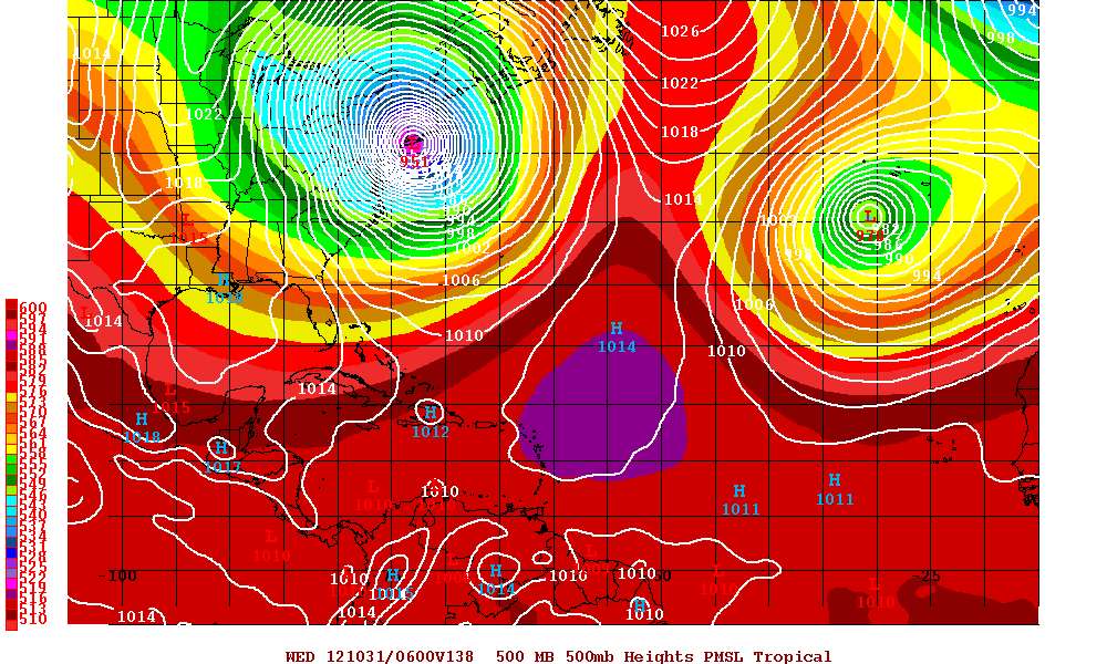
hmmm gfs come way left as it near northern bahamas and slows way way down does almost a complete loop. well I guess not that much left but a little from the 6z but about 80 miles sw from the 00z .
http://mag.ncep.noaa.gov/NCOMAGWEB/appc ... mageSize=M
http://mag.ncep.noaa.gov/NCOMAGWEB/appc ... mageSize=M
0 likes
Note: If I make a post that is brief. Please refer back to previous posts for the analysis or reasoning. I do not re-write/qoute what my initial post said each time.
If there is nothing before... then just ask
Space & Atmospheric Physicist, Embry-Riddle Aeronautical University,
I believe the sky is falling...
If there is nothing before... then just ask
Space & Atmospheric Physicist, Embry-Riddle Aeronautical University,
I believe the sky is falling...
-
brunota2003

- S2K Supporter

- Posts: 9476
- Age: 33
- Joined: Sat Jul 30, 2005 9:56 pm
- Location: Stanton, KY...formerly Havelock, NC
- Contact:
-
Bocadude85
- Category 5
- Posts: 2941
- Age: 37
- Joined: Mon Apr 18, 2005 2:20 pm
- Location: Honolulu,Hi
Re:
Aric Dunn wrote:hmmm gfs come way left as it near northern bahamas and slows way way down does almost a complete loop.
http://mag.ncep.noaa.gov/NCOMAGWEB/appc ... mageSize=M
Yea its quite a bit further southwest of the 6zGFS
0 likes
-
MiamiensisWx
Re: ATL: SANDY - Models
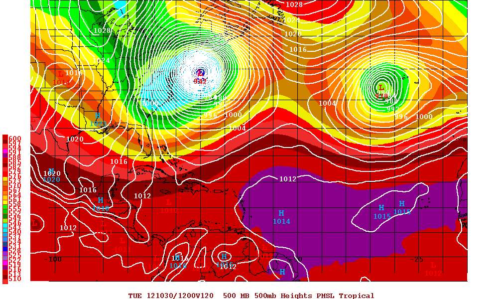
12Z GFS suggests sustained winds of 40-45 kt from Fort Lauderdale northward for ~24 hours between 12Z Friday and 12Z Saturday...ouch. Winds are even near 50 kt near Stuart around 00Z Saturday. The onshore fetch means east-central FL will take most of the severe beach erosion on its chin, whereas SE FL would be less exposed due to NNW (offshore) flow prevailing.
0 likes
-
DESTRUCTION5

- Category 5
- Posts: 4391
- Age: 42
- Joined: Wed Sep 03, 2003 11:25 am
- Location: Stuart, FL
Re: ATL: SANDY - Models
GFS 12z
http://raleighwx.americanwx.com/models/ ... cal012.gif
http://raleighwx.americanwx.com/models/ ... cal024.gif
http://raleighwx.americanwx.com/models/ ... cal030.gif
http://raleighwx.americanwx.com/models/ ... cal036.gif
http://raleighwx.americanwx.com/models/ ... cal042.gif
http://raleighwx.americanwx.com/models/ ... cal048.gif
0 likes
GATOR NATION IS E V E R Y W H E R E !
-
deltadog03

- Professional-Met

- Posts: 3580
- Joined: Tue Jul 05, 2005 6:16 pm
- Location: Macon, GA
-
DESTRUCTION5
- Category 5
- Posts: 4391
- Age: 42
- Joined: Wed Sep 03, 2003 11:25 am
- Location: Stuart, FL
Re:
deltadog03 wrote:gfs is landfall nyc
indeed...NASTY
0 likes
GATOR NATION IS E V E R Y W H E R E !
-
tolakram
- Admin

- Posts: 19165
- Age: 60
- Joined: Sun Aug 27, 2006 8:23 pm
- Location: Florence, KY (name is Mark)
Re: ATL: SANDY - Models
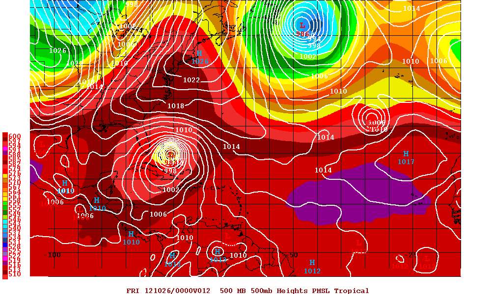
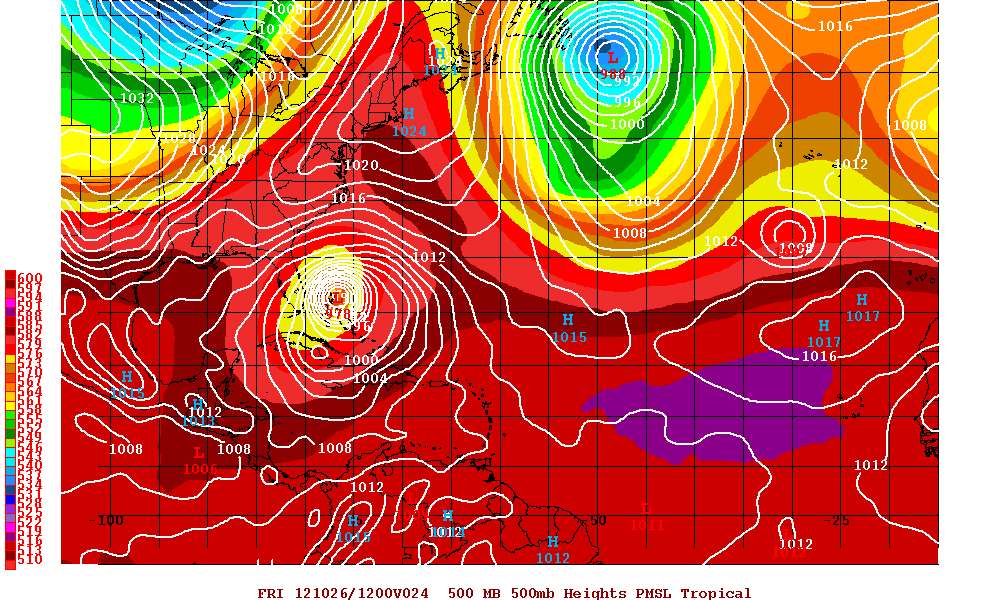
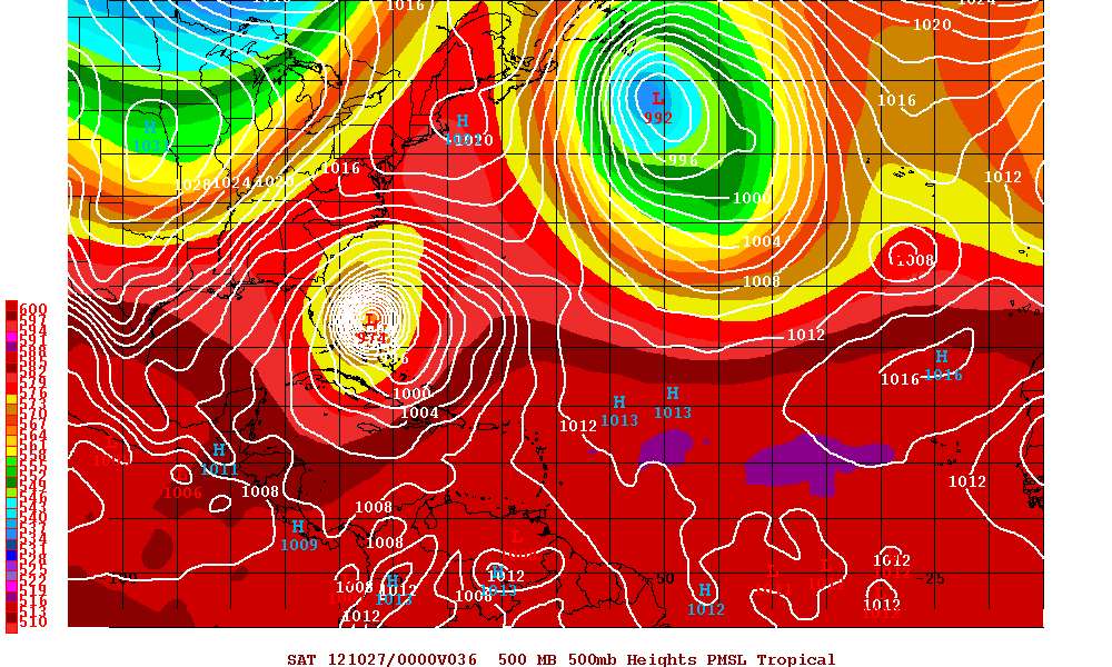
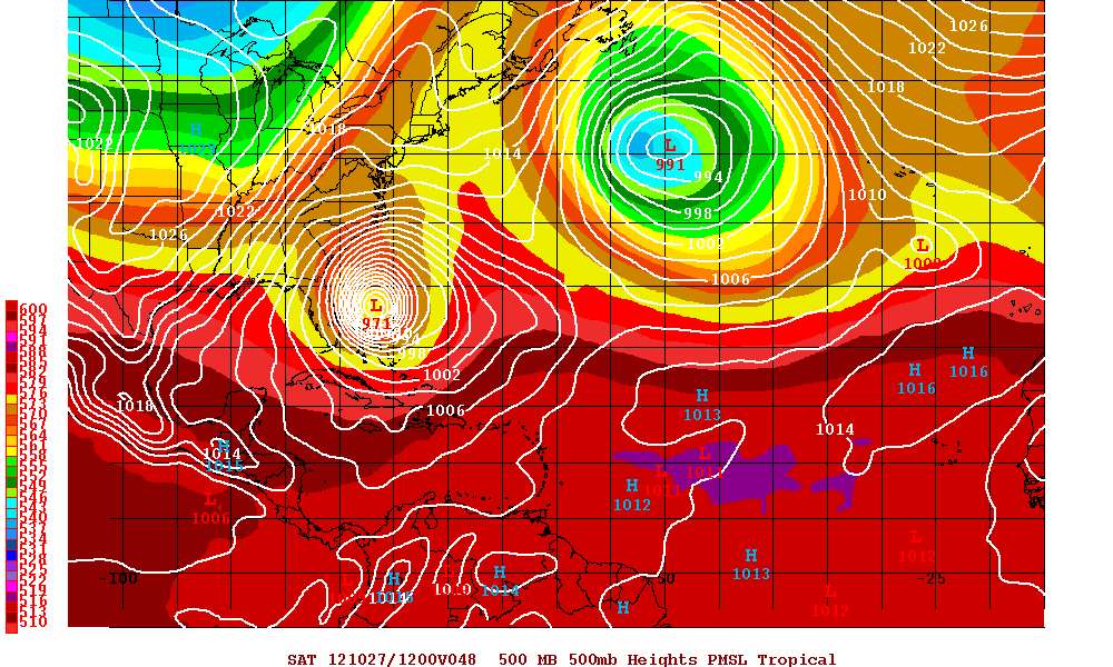
Saved images from latest run


0 likes
M a r k
- - - - -
Join us in chat: Storm2K Chatroom Invite. Android and IOS apps also available.
The posts in this forum are NOT official forecasts and should not be used as such. Posts are NOT endorsed by any professional institution or STORM2K.org. For official information and forecasts, please refer to NHC and NWS products.

-
x-y-no

- Category 5
- Posts: 8359
- Age: 63
- Joined: Wed Aug 11, 2004 12:14 pm
- Location: Fort Lauderdale, FL
Re: Re:
Cyclenall wrote:deltadog03 wrote:gfs is landfall nyc
It has come home to PAPA! It caved to King Euro under its shine. Now to see the exact pressure and details.
Actually, landfall Long Island and then northwest into Connecticut. But close enough for government work.
0 likes
-
sicktght311
- Tropical Depression

- Posts: 67
- Joined: Thu Sep 02, 2010 11:31 am
Re: ATL: SANDY - Models
Wow, unreal that you can see long island straight into the center of that bullseye in the last frame.
I still think we're a few days away from having a more concrete solution, but this is a huge awakening for anyone in the NY metro area. That bullseye is pretty much right over me
I still think we're a few days away from having a more concrete solution, but this is a huge awakening for anyone in the NY metro area. That bullseye is pretty much right over me
0 likes

Re: ATL: SANDY - Models
Dr Maue:
"Sandy not going to anything but a full-fledged hurricane until landfall w/GFS & ECMWF. Then it can merge with trough.
Full T574 GFS spectral output (27-km) resolution shows ~930 mb surface pressure for Sandy prior to landfall"
http://twitter.com/RyanMaue
"Sandy not going to anything but a full-fledged hurricane until landfall w/GFS & ECMWF. Then it can merge with trough.
Full T574 GFS spectral output (27-km) resolution shows ~930 mb surface pressure for Sandy prior to landfall"
http://twitter.com/RyanMaue
0 likes
Who is online
Users browsing this forum: No registered users and 48 guests