ATL: INVEST 90L - Discussion
Moderator: S2k Moderators
- cycloneye
- Admin
- Posts: 142555
- Age: 68
- Joined: Thu Oct 10, 2002 10:54 am
- Location: San Juan, Puerto Rico
ATL: INVEST 90L - Discussion
AL, 90, 2014090306, , BEST, 0, 149N, 121W, 15, 1010, LO, 0, , 0, 0, 0, 0, 1012, 200, 80, 0, 0,
AL, 90, 2014090312, , BEST, 0, 146N, 136W, 15, 1010, LO, 0, , 0, 0, 0, 0, 1012, 200, 80, 0, 0,
AL, 90, 2014090318, , BEST, 0, 142N, 151W, 15, 1010, LO, 0, , 0, 0, 0, 0, 1012, 200, 80, 0, 0,
AL, 90, 2014090400, , BEST, 0, 136N, 165W, 20, 1009, LO, 0, , 0, 0, 0, 0, 1012, 200, 70, 0, 0,
AL, 90, 2014090406, , BEST, 0, 128N, 178W, 20, 1009, LO, 34, NEQ, 0, 0, 0, 0, 1012, 200, 70, 0, 0, L, 0, ,
Thread at Talking Tropics forum that was the topic for this area.
viewtopic.php?f=31&t=116685&start=0
0 likes
Visit the Caribbean-Central America Weather Thread where you can find at first post web cams,radars
and observations from Caribbean basin members Click Here
- ouragans
- Category 1
- Posts: 480
- Age: 53
- Joined: Sun Jun 12, 2011 12:09 pm
- Location: Abymes, Guadeloupe F.W.I
- Contact:
Re: ATL: INVEST 90L - Discussion
Up to 40%
TROPICAL WEATHER OUTLOOK
NWS NATIONAL HURRICANE CENTER MIAMI FL
200 AM EDT THU SEP 4 2014
For the North Atlantic...Caribbean Sea and the Gulf of Mexico:
1. A tropical wave, accompanied by a broad low pressure system, has
emerged off the coast of Africa a few hundred miles east-southeast
of the Cape Verde Islands. Environmental conditions are expected to
be conducive for gradual development of this disturbance through
early next week while it moves westward at about 15 mph.
* Formation chance through 48 hours...low...10 percent.
* Formation chance through 5 days...medium...40 percent.
Forecaster Stewart
0 likes
Personal forecast disclaimer
This post is a personal point of view, not an information. Please refer to official statements for life-threatening decisions.
David '79, Frederic '79, Hugo '89, Iris, Luis & Marilyn '95, Georges '98, Lenny '99, Dean '07, Irma '17, Maria '17, Fiona '22, Philippe '23, Tammy '23
16°13'33.3,"6N -61°36'39.5"W
- Gustywind
- Category 5
- Posts: 12334
- Joined: Mon Sep 03, 2007 7:29 am
- Location: Baie-Mahault, GUADELOUPE
What is the future of this twave with all that dry air north of it? That should be a difficult trip but as we're approaching the peak we must have to keep an eye on... Note that this is a good news that 90L have not already poofed .
Time will tell.
http://tropic.ssec.wisc.edu/real-time/sal/splitE.jpg
Time will tell.
http://tropic.ssec.wisc.edu/real-time/sal/splitE.jpg
0 likes
- Gustywind
- Category 5
- Posts: 12334
- Joined: Mon Sep 03, 2007 7:29 am
- Location: Baie-Mahault, GUADELOUPE
From the Weather Channel
Stu Ostro, Michael Lowry, Dr. Greg Postel Published: Sep 4, 2014, 5:46 AM EDT weather.com
ATLANTIC
http://www.weather.com/news/tropical-up ... n-20140513
A strong tropical wave with a circular appearance already is coming off Africa. Models are not bullish on its development potential, while also not turning it out to sea anytime soon either. There's an even stronger "African easterly wave" that'll be heading into the Atlantic in a few days. It too will have various atmospheric adversaries to overcome in order to survive all the way across, but the ultimate outcome is a long way off and yet t.b.d.
0 likes
- Gustywind
- Category 5
- Posts: 12334
- Joined: Mon Sep 03, 2007 7:29 am
- Location: Baie-Mahault, GUADELOUPE
Very interresting discussion from Jeff Masters
http://www.wunderground.com/blog/JeffMa ... rynum=2784
New African tropical wave this weekend may develop
A tropical wave is expected to come off the coast of Africa on Thursday and move to the west at about 15 mph. This wave will be capable of bringing heavy rain and strong winds to the Cape Verde Islands on Friday and Saturday. Two of our three reliable computer models for predicting tropical storm formation show development by Sunday of the wave, and in their 8 am EDT Wednesday Tropical Weather Outlook, NHC gave the system 2-day and 5-day odd of development odds of 0% and 30%, respectively. The Wednesday morning runs of the GFS and European ensemble models favored the storm taking a more west-northwesterly track into the open ocean next week, with a low long-range threat to the Lesser Antilles Islands indicated. However, it is too early to be confident that the storm will miss the islands, as the long-range tracks have shifted closer to the Lesser Antilles since their runs on Tuesday. The Atlantic is expected to be dominated by dry, sinking air next week, due to the phase of the Madden Julian Oscillation (MJO), a pattern of increased thunderstorm activity near the Equator that moves around the globe in 30 - 60 days, so I expect that any tropical waves crossing from Africa towards the Lesser Antilles will struggle to develop.
Jeff Masters
0 likes
- cycloneye
- Admin
- Posts: 142555
- Age: 68
- Joined: Thu Oct 10, 2002 10:54 am
- Location: San Juan, Puerto Rico
Re: ATL: INVEST 90L - Discussion
TROPICAL WEATHER OUTLOOK
NWS NATIONAL HURRICANE CENTER MIAMI FL
800 AM EDT THU SEP 4 2014
For the North Atlantic...Caribbean Sea and the Gulf of Mexico:
1. A tropical wave, accompanied by a broad low pressure system, is
located a few hundred miles east-southeast of the Cape Verde
Islands. Environmental conditions are expected to be conducive for
some development of this disturbance through early next week while
it moves westward at about 15 mph.
* Formation chance through 48 hours...low...10 percent.
* Formation chance through 5 days...medium...40 percent.
Forecaster Pasch
0 likes
Visit the Caribbean-Central America Weather Thread where you can find at first post web cams,radars
and observations from Caribbean basin members Click Here
- northjaxpro
- S2K Supporter
- Posts: 8900
- Joined: Mon Sep 27, 2010 11:21 am
- Location: Jacksonville, FL
Of course, the saga of the 2014 North Atlantic Hurricane season continues. Will the ambundant dry and stable air destroy another in a series of these African waves? Or will 90L somehow survive to last in the next few days?
Last edited by northjaxpro on Thu Sep 04, 2014 7:18 am, edited 1 time in total.
0 likes
NEVER, EVER SAY NEVER in the tropics and weather in general, and most importantly, with life itself!!
________________________________________________________________________________________
Fay 2008 Beryl 2012 Debby 2012 Colin 2016 Hermine 2016 Julia 2016 Matthew 2016 Irma 2017 Dorian 2019
________________________________________________________________________________________
Fay 2008 Beryl 2012 Debby 2012 Colin 2016 Hermine 2016 Julia 2016 Matthew 2016 Irma 2017 Dorian 2019
- cycloneye
- Admin
- Posts: 142555
- Age: 68
- Joined: Thu Oct 10, 2002 10:54 am
- Location: San Juan, Puerto Rico
Re: ATL: INVEST 90L - Discussion
8 AM TWD:
A TROPICAL WAVE IS OVER THE EASTERN ATLANTIC WITH AXIS NEAR
19N41W TO 05N44W MOVING W AT 15-20 KT. SSMI TOTAL PRECIPITABLE
WATER VAPOR IMAGERY SHOWS A LARGE MOIST AREA IN THE VICINITY OF
THIS WAVE. ISOLATED MODERATE CONVECTION REMAINS W OF THE WAVE
AXIS E OF 40W...BETWEEN 11-15N.
A TROPICAL WAVE IS OVER THE EASTERN ATLANTIC WITH AXIS NEAR
19N41W TO 05N44W MOVING W AT 15-20 KT. SSMI TOTAL PRECIPITABLE
WATER VAPOR IMAGERY SHOWS A LARGE MOIST AREA IN THE VICINITY OF
THIS WAVE. ISOLATED MODERATE CONVECTION REMAINS W OF THE WAVE
AXIS E OF 40W...BETWEEN 11-15N.
0 likes
Visit the Caribbean-Central America Weather Thread where you can find at first post web cams,radars
and observations from Caribbean basin members Click Here
-
- Admin
- Posts: 19924
- Age: 61
- Joined: Sun Aug 27, 2006 8:23 pm
- Location: Florence, KY (name is Mark)
Re: ATL: INVEST 90L - Discussion
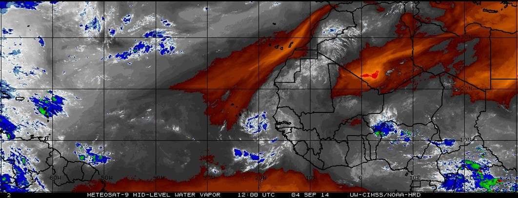
Mid level water vapor looks moist enough, certainly a lot better than earlier in the year.
source: http://tropic.ssec.wisc.edu/real-time/salmain.php?&prod=wvmid&time=
0 likes
M a r k
- - - - -
Join us in chat: Storm2K Chatroom Invite. Android and IOS apps also available.
The posts in this forum are NOT official forecasts and should not be used as such. Posts are NOT endorsed by any professional institution or STORM2K.org. For official information and forecasts, please refer to NHC and NWS products.
- TheStormExpert
- Category 5
- Posts: 8487
- Age: 31
- Joined: Wed Feb 16, 2011 5:38 pm
- Location: Palm Beach Gardens, FL
-
- Admin
- Posts: 19924
- Age: 61
- Joined: Sun Aug 27, 2006 8:23 pm
- Location: Florence, KY (name is Mark)
Re: ATL: INVEST 90L - Discussion
live visible loop: http://rammb.cira.colostate.edu/ramsdis/online/loop_meteosat.asp?data_folder=tropical/tropical_met_14km_visir2&width=640&height=480&number_of_images_to_display=24
0 likes
M a r k
- - - - -
Join us in chat: Storm2K Chatroom Invite. Android and IOS apps also available.
The posts in this forum are NOT official forecasts and should not be used as such. Posts are NOT endorsed by any professional institution or STORM2K.org. For official information and forecasts, please refer to NHC and NWS products.
- - - - -
Join us in chat: Storm2K Chatroom Invite. Android and IOS apps also available.
The posts in this forum are NOT official forecasts and should not be used as such. Posts are NOT endorsed by any professional institution or STORM2K.org. For official information and forecasts, please refer to NHC and NWS products.
- meriland23
- Category 5
- Posts: 1239
- Age: 36
- Joined: Mon Aug 29, 2011 9:29 pm
Re: ATL: INVEST 90L - Discussion
Why is it collapsing?
0 likes
The posts in this forum are NOT official forecast and should not be used as such. They are just the opinion of the poster and may or may not be backed by sound meteorological data. They are NOT endorsed by any professional institution or storm2k.org. For official information, please refer to the NHC and NWS products.
- gatorcane
- S2K Supporter
- Posts: 23651
- Age: 46
- Joined: Sun Mar 13, 2005 3:54 pm
- Location: Boca Raton, FL
Re: ATL: INVEST 90L - Discussion
cycloneye wrote:TROPICAL WEATHER OUTLOOK
NWS NATIONAL HURRICANE CENTER MIAMI FL
800 AM EDT THU SEP 4 2014
For the North Atlantic...Caribbean Sea and the Gulf of Mexico:
1. A tropical wave, accompanied by a broad low pressure system, is
located a few hundred miles east-southeast of the Cape Verde
Islands. Environmental conditions are expected to be conducive for
some development of this disturbance through early next week while
it moves westward at about 15 mph.
* Formation chance through 48 hours...low...10 percent.
* Formation chance through 5 days...medium...40 percent.
Forecaster Pasch
0 likes
Re: ATL: INVEST 90L - Discussion
Few storms seem to be taking this year. The GOM seems to be ready now but there are no disturbances entering it.
0 likes
- SFLcane
- S2K Supporter
- Posts: 10104
- Age: 47
- Joined: Sat Jun 05, 2010 1:44 pm
- Location: Lake Worth Florida
Re: ATL: INVEST 90L - Discussion
meriland23 wrote:Why is it collapsing?
Likely the same issue most systems this year have had. Dry sinking airmass ahead will most likely keep this from developing anytime soon. Wouldn't be surprised if this a naked convection free swirl in a few days.
0 likes
-
- Category 5
- Posts: 2623
- Joined: Sun Aug 12, 2007 3:45 am
- Location: Florida State University
Re: ATL: INVEST 90L - Discussion
Cooler then normal SSTs plus dry air is what caused the convection to collapse. It'll take some time to adjust to its new environment.
0 likes
-
- Tropical Storm
- Posts: 106
- Age: 29
- Joined: Wed Aug 27, 2014 9:18 pm
- Location: Hattiesburg, MS
- Contact:
Re: ATL: INVEST 90L - Discussion
what does sst mean?
0 likes
Okay guys, just because I want to BE a meteorologist, want to go to school for meteorology, DOES NOT MAKE ME A METEOROLOGIST. Anything I say about tropical weather is either me learning something new, or is just an opinion and nothing more than that. I can almost guarantee you that I will be wrong about pretty much everything.
- crownweather
- S2K Supporter
- Posts: 587
- Age: 50
- Joined: Sat Aug 12, 2006 9:21 am
- Location: Sturbridge, Massachusetts
- Contact:
Who is online
Users browsing this forum: No registered users and 2 guests