EPAC: BLAS - Post-Tropical

Moderator: S2k Moderators

Message
Author
Alyono
Professional-Met
Professional-Met
Posts: 6961
Joined: Fri Apr 26, 2013 3:52 pm
Location: Texas Coast

Re: EPAC: BLAS - Hurricane

#221 Postby Alyono » Tue Jul 05, 2016 9:48 pm

Yellow Evan wrote:
Alyono wrote:NHC is likely killing this off a bit too quick.

EC is showing a strong TS at 144 hours. I think it's because their track is including the MU, which is resulting in SSTs that are far too cold


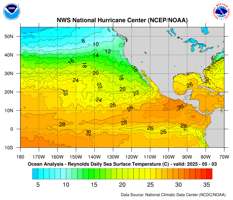
The SHIPS output seems to be showing SSTs are too cold when compared to Reynolds/CDAS.


it's matching Reynolds just fine

http://www.nhc.noaa.gov/tafb/sst_loop/14_pac.png


TIME (HR) 0 6 12 18 24 36 48 60 72 84 96 108 120
V (KT) NO LAND 115 124 128 129 127 114 97 87 71 60 46 37 29
V (KT) LAND 115 124 128 129 127 114 97 87 71 60 46 37 29
V (KT) LGEM 115 120 120 116 109 93 79 67 56 45 35 27 21
Storm Type TROP TROP TROP TROP TROP TROP TROP TROP TROP TROP TROP TROP TROP

SHEAR (KT) 5 4 3 5 7 7 10 5 10 9 7 7 6
SHEAR ADJ (KT) -1 -1 0 -2 0 9 11 11 11 14 18 14 7
SHEAR DIR 24 48 50 50 62 79 61 81 134 183 218 245 221
SST (C) 28.0 27.9 27.7 27.4 26.8 26.0 26.0 25.8 25.0 24.1 23.9 24.3 24.6

The issue is, the track may be too far north

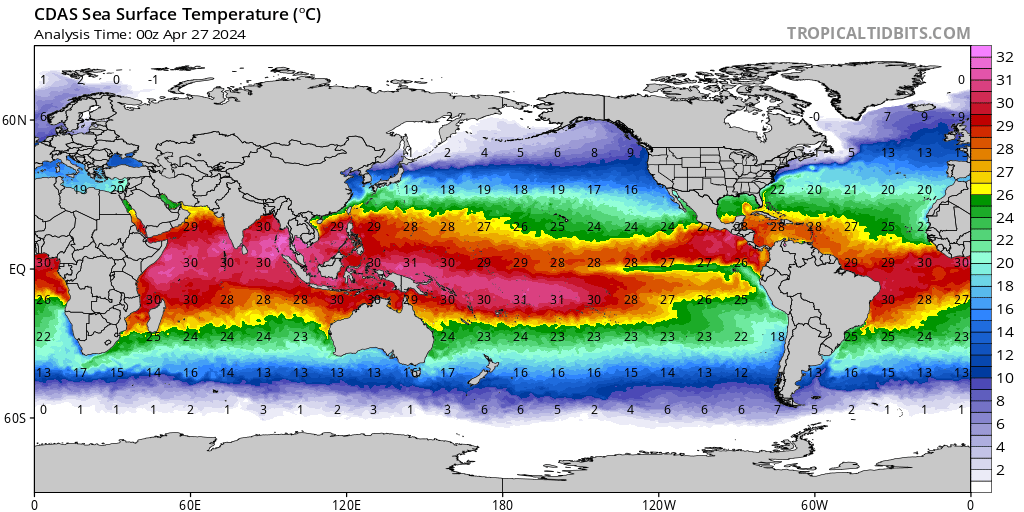
Levi Cowen's site has warmer SSTs

http://www.tropicaltidbits.com/analysis ... obal_1.png

I don't think this will matter as I think this will pass several hundred miles SOUTH of Hawaii
0 likes   

stormwise
Category 2
Category 2
Posts: 590
Joined: Sun Dec 27, 2015 7:39 pm

Re: EPAC: BLAS - Hurricane

#222 Postby stormwise » Tue Jul 05, 2016 10:10 pm

Image

Image
EC deterministic @240hrs with that close interaction if it comes to fruition who knows where it will go.
0 likes   

User avatar
Yellow Evan
Professional-Met
Professional-Met
Posts: 15951
Age: 25
Joined: Fri Jul 15, 2011 12:48 pm
Location: Henderson, Nevada/Honolulu, HI
Contact:

Re: EPAC: BLAS - Hurricane

#223 Postby Yellow Evan » Tue Jul 05, 2016 10:12 pm

Image

On the cusp between T6.5 and T7.0 raw DT
0 likes   

User avatar
1900hurricane
Category 5
Category 5
Posts: 6044
Age: 32
Joined: Fri Feb 06, 2015 12:04 pm
Location: Houston, TX
Contact:

Re: EPAC: BLAS - Hurricane

#224 Postby 1900hurricane » Tue Jul 05, 2016 11:08 pm

The eyewall is still weak in the NW quad, which probably explains some of the convective irregularities.

Image
0 likes   
Contract Meteorologist. TAMU & MSST. Fiercely authentic, one of a kind. We are all given free will, so choose a life meant to be lived. We are the Masters of our own Stories.
Opinions expressed are mine alone.

Follow me on Twitter at @1900hurricane : Read blogs at https://1900hurricane.wordpress.com/

User avatar
Yellow Evan
Professional-Met
Professional-Met
Posts: 15951
Age: 25
Joined: Fri Jul 15, 2011 12:48 pm
Location: Henderson, Nevada/Honolulu, HI
Contact:

Re: EPAC: BLAS - Hurricane

#225 Postby Yellow Evan » Tue Jul 05, 2016 11:49 pm

Code: Select all

            ----- Current Analysis -----
     Date :  06 JUL 2016    Time :   040000 UTC
      Lat :   14:23:17 N     Lon :  121:49:39 W

     
                CI# /Pressure/ Vmax
                6.4 / 942.9mb/124.6kt

     
             Final T#  Adj T#  Raw T#
                6.4     6.4     6.4

 Estimated radius of max. wind based on IR : 20 km

 Center Temp :  +9.0C    Cloud Region Temp : -68.5C

 Scene Type : EYE 
0 likes   

stormwise
Category 2
Category 2
Posts: 590
Joined: Sun Dec 27, 2015 7:39 pm

Re: EPAC: BLAS - Hurricane

#226 Postby stormwise » Wed Jul 06, 2016 12:43 am

Image
0 likes   

User avatar
Extratropical94
Professional-Met
Professional-Met
Posts: 3535
Age: 29
Joined: Wed Oct 20, 2010 6:36 am
Location: Hamburg, Germany
Contact:

Re: EPAC: BLAS - Hurricane

#227 Postby Extratropical94 » Wed Jul 06, 2016 1:52 am

03E BLAS 160706 0600 14.5N 122.1W EPAC 115 951
0 likes   
54° 11' 59'' N, 9° 9' 20'' E
Boomer Sooner!
Go Broncos! Go Cards! Go Niners!
- Daniel

User avatar
Kingarabian
S2K Supporter
S2K Supporter
Posts: 15433
Joined: Sat Aug 08, 2009 3:06 am
Location: Honolulu, Hawaii

Re: EPAC: BLAS - Hurricane

#228 Postby Kingarabian » Wed Jul 06, 2016 2:28 am

WOW!

Major hurricane!

Excited to see the first major of the 2016 season. Looks breathtaking.
0 likes   
RIP Kobe Bryant

User avatar
cycloneye
Admin
Admin
Posts: 139029
Age: 67
Joined: Thu Oct 10, 2002 10:54 am
Location: San Juan, Puerto Rico

Re: EPAC: BLAS - Hurricane

#229 Postby cycloneye » Wed Jul 06, 2016 4:58 am

HURRICANE BLAS DISCUSSION NUMBER 14
NWS NATIONAL HURRICANE CENTER MIAMI FL EP032016
200 AM PDT WED JUL 06 2016

The satellite presentation of Blas has degraded since the previous
advisory, as the convective ring surrounding the eye had warmed and
shrunk. The eye, however, remains distinct in infrared imagery. The
initial intensity has been lowered to 110 kt, which is a little
above a blend of the latest Dvorak CI and Final-T numbers from TAFB
and SAB. Sea surface temperatures gradually cool along the forecast
track, which should result in weakening, albeit at a slow pace
during the first day or so. After 24 hours the rate of weakening
should increase as SSTs fall below 27C. Blas is expected to become
a post-tropical cyclone in about 4 days and a remnant low by day 5.
The new NHC intensity forecast is close to or a little above the
latest LGEM and IVCN intensity consensus.

The initial motion estimate is 280/10, as Blas has begun to gain
some latitude. Blas should move west-northwestward for the next 48
hours while being steered around the southwestern periphery of a
mid-level ridge centered over Mexico. After that time the model
spread increases. The GFS based guidance, including the HWRF and
GFDL, shows Blas turning northwestward late in the period as it
interacts with an upper-level low northeast of the Hawaiian Islands.
The ECMWF continues to show less interaction between Blas and the
upper-level low and has the cyclone turning westward at days 4-5.
Given the continued spread in the guidance, the NHC track forecast
will stay in the middle of the two extremes and shows a
northwestward to west-northwestward motion at days 4-5. This
forecast is a little south of the latest GFS/ECMWF consensus. Given
the uncertainty, there is low confidence in the details of the track
forecast late in the period.

FORECAST POSITIONS AND MAX WINDS

INIT 06/0900Z 14.7N 122.7W 110 KT 125 MPH
12H 06/1800Z 15.1N 124.2W 105 KT 120 MPH
24H 07/0600Z 15.7N 126.3W 100 KT 115 MPH
36H 07/1800Z 16.3N 128.1W 90 KT 105 MPH
48H 08/0600Z 16.9N 129.7W 75 KT 85 MPH
72H 09/0600Z 18.8N 132.6W 55 KT 65 MPH
96H 10/0600Z 21.0N 136.0W 35 KT 40 MPH...POST-TROPICAL
120H 11/0600Z 22.5N 140.0W 25 KT 30 MPH...POST-TROP/REMNT LOW

$$
Forecaster Brennan
0 likes   
Visit the Caribbean-Central America Weather Thread where you can find at first post web cams,radars
and observations from Caribbean basin members Click Here

User avatar
1900hurricane
Category 5
Category 5
Posts: 6044
Age: 32
Joined: Fri Feb 06, 2015 12:04 pm
Location: Houston, TX
Contact:

Re: EPAC: BLAS - Hurricane

#230 Postby 1900hurricane » Wed Jul 06, 2016 10:04 am

Blas's eyewall looks much more complete now.

Image
0 likes   
Contract Meteorologist. TAMU & MSST. Fiercely authentic, one of a kind. We are all given free will, so choose a life meant to be lived. We are the Masters of our own Stories.
Opinions expressed are mine alone.

Follow me on Twitter at @1900hurricane : Read blogs at https://1900hurricane.wordpress.com/

User avatar
bg1
Category 1
Category 1
Posts: 408
Joined: Fri May 13, 2011 11:14 am
Location: near Santee, SC

Re: EPAC: BLAS - Hurricane

#231 Postby bg1 » Wed Jul 06, 2016 10:34 am

Hmmm...
NHC wrote:Blas has characteristics of an annular
hurricane
with a large 25 to 30 n mi wide eye surrounded by a symmetric convective ring with little outer banding features.
0 likes   

User avatar
Yellow Evan
Professional-Met
Professional-Met
Posts: 15951
Age: 25
Joined: Fri Jul 15, 2011 12:48 pm
Location: Henderson, Nevada/Honolulu, HI
Contact:

Re: EPAC: BLAS - Hurricane

#232 Postby Yellow Evan » Wed Jul 06, 2016 10:41 am

000
WTPZ43 KNHC 061442
TCDEP3

HURRICANE BLAS DISCUSSION NUMBER 15
NWS NATIONAL HURRICANE CENTER MIAMI FL EP032016
800 AM PDT WED JUL 06 2016

The overall satellite appearance of Blas has changed little since
early this morning. Blas has characteristics of an annular
hurricane with a large 25 to 30 n mi wide eye surrounded by a
symmetric convective ring with little outer banding features. The
initial intensity remains 110 kt, and is a blend of the various
objective and subjective Dvorak satellite intensity estimates.
Blas is currently in a low shear environment and over SSTs of 27-28
degrees Celsius. Although the shear is forecast to remain low for
the next several days, decreasing sea surface temperatures along the
forecast track should result in gradual weakening of the hurricane
during the next 24 to 36 hours. After that time, Blas will be
moving over SSTs below 26C which should cause a faster rate of
weakening, and the cyclone is forecast to become post-tropical in
about 4 days. The NHC intensity forecast is similar to the previous
advisory and lies between the SHIPS and LGEM models.

Blas is moving west-northwestward or 285 degrees at 10 kt, and
should continue on this general motion during the next 36 to 48
hours while it moves around the southwestern portion of a mid-level
ridge over northern Mexico. By 72 hours, the model guidance begins
to diverge with the GFS, HWRF, GFDL, and GFS ensemble mean taking
Blas northwestward around the eastern portion of a large mid- to
upper-level low to the northeast of Hawaii. The ECMWF and UKMET
models show a more westward track, with less interaction between the
upper-low and the hurricane. This appears to be the result of the
size, location, and orientation of the upper-low in the various
models. Given the large spread in the guidance, there is low
confidence in the the track forecast late in the period, and the NHC
forecast track remains near the GFS/ECMWF consensus at days 3-5.


FORECAST POSITIONS AND MAX WINDS

INIT 06/1500Z 15.0N 123.6W 110 KT 125 MPH
12H 07/0000Z 15.4N 125.2W 105 KT 120 MPH
24H 07/1200Z 16.0N 127.1W 95 KT 110 MPH
36H 08/0000Z 16.6N 128.8W 85 KT 100 MPH
48H 08/1200Z 17.5N 130.4W 70 KT 80 MPH
72H 09/1200Z 19.6N 133.3W 50 KT 60 MPH
96H 10/1200Z 21.8N 137.0W 35 KT 40 MPH...POST-TROPICAL
120H 11/1200Z 22.5N 140.5W 25 KT 30 MPH...POST-TROP/REMNT LOW

$$
Forecaster Brown
0 likes   

User avatar
Kingarabian
S2K Supporter
S2K Supporter
Posts: 15433
Joined: Sat Aug 08, 2009 3:06 am
Location: Honolulu, Hawaii

Re: EPAC: BLAS - Hurricane

#233 Postby Kingarabian » Wed Jul 06, 2016 11:04 am

Image
0 likes   
RIP Kobe Bryant

User avatar
Yellow Evan
Professional-Met
Professional-Met
Posts: 15951
Age: 25
Joined: Fri Jul 15, 2011 12:48 pm
Location: Henderson, Nevada/Honolulu, HI
Contact:

Re: EPAC: BLAS - Hurricane

#234 Postby Yellow Evan » Wed Jul 06, 2016 1:33 pm

Still holding its own

Code: Select all

            ----- Current Analysis -----
     Date :  06 JUL 2016    Time :   173000 UTC
      Lat :   15:08:57 N     Lon :  124:05:31 W

     
                CI# /Pressure/ Vmax
                6.1 / 948.1mb/117.4kt

     
             Final T#  Adj T#  Raw T#
                6.1     6.2     6.2

 Estimated radius of max. wind based on IR : 31 km

 Center Temp : +12.9C    Cloud Region Temp : -65.3C

 Scene Type : EYE 
0 likes   

User avatar
Yellow Evan
Professional-Met
Professional-Met
Posts: 15951
Age: 25
Joined: Fri Jul 15, 2011 12:48 pm
Location: Henderson, Nevada/Honolulu, HI
Contact:

Re: EPAC: BLAS - Hurricane

#235 Postby Yellow Evan » Wed Jul 06, 2016 2:00 pm

Code: Select all

                   * EAST PACIFIC SHIPS INTENSITY FORECAST          *
                    * IR SAT DATA AVAILABLE,       OHC AVAILABLE     *
                    *  BLAS        EP032016  07/06/16  18 UTC        *

TIME (HR)          0     6    12    18    24    36    48    60    72    84    96   108   120
V (KT) NO LAND   110   108   106   103   101    91    81    70    58    48    37    30    24
V (KT) LAND      110   108   106   103   101    91    81    70    58    48    37    30    24
V (KT) LGEM      110   104    97    90    83    72    62    52    42    33    26    20    16
Storm Type      TROP  TROP  TROP  TROP  TROP  TROP  TROP  TROP  TROP  TROP  TROP  TROP  TROP

SHEAR (KT)         3     3     4     7     9     9    11    14    12     7    13    17    27
SHEAR ADJ (KT)     0     4     4     4     6     7     4     9     9    20    13    14     7
SHEAR DIR        216   120    88   108    96    99   130   155   186   183   235   240   256
SST (C)         27.4  26.8  26.3  26.0  25.9  25.8  25.1  24.3  23.7  23.8  24.0  24.2  24.4
POT. INT. (KT)   138   132   126   123   122   121   113   105    99   101   103   104   105
200 MB T (C)   -51.9 -51.2 -51.7 -51.8 -51.5 -51.8 -51.9 -51.6 -52.2 -51.9 -52.0 -52.4 -52.9
200 MB VXT (C)   0.4   0.5   0.5   0.6   0.6   0.9   0.5   0.7   0.8   0.4   0.1   0.2   0.2
TH_E DEV (C)       6     6     5     5     4     4     3     3     3     3     3     3     3
700-500 MB RH     67    65    65    65    65    66    61    55    49    43    39    34    28
MODEL VTX (KT)    32    35    33    33    35    33    32    30    26    24    19    16    14
850 MB ENV VOR    26    35    44    44    49    66    61    57    32    21     7    14     9
200 MB DIV        91    86    78    71    60    74    53    47    20     4    15     0     0
700-850 TADV      -1     0     3     5     5     6     8    23    23    15    10    10     7
LAND (KM)       1645  1704  1768  1809  1850  1928  1983  2038  2107  1968  1761  1593  1437
LAT (DEG N)     15.1  15.5  15.8  16.1  16.3  17.0  18.0  19.1  20.2  21.3  22.3  22.6  22.4
LONG(DEG W)    124.2 125.3 126.3 127.2 128.0 129.7 131.2 132.6 134.2 136.0 138.1 139.8 141.3
STM SPEED (KT)    11    11    10     9     9     9     9     9    10    10    10     7     7
HEAT CONTENT      26    15     6     3     3     0     0     0     0     0     0     0     0

  FORECAST TRACK FROM OFCI      INITIAL HEADING/SPEED (DEG/KT):285/ 11      CX,CY: -10/  3
  T-12 MAX WIND: 115            PRESSURE OF STEERING LEVEL (MB):  630  (MEAN=586)
  GOES IR BRIGHTNESS TEMP. STD DEV.  50-200 KM RAD:   6.8 (MEAN=14.5)
  % GOES IR PIXELS WITH T < -20 C    50-200 KM RAD:  97.0 (MEAN=65.0)
  PRELIM RI PROB (DV .GE. 30 KT IN 24 HR):            0.0

                        INDIVIDUAL CONTRIBUTIONS TO INTENSITY CHANGE
                         6   12   18   24   36   48   60   72   84   96  108  120
                        ----------------------------------------------------------
  SAMPLE MEAN CHANGE     0.   0.   1.   1.   1.   1.   1.   1.   0.  -1.  -1.  -2.
  SST POTENTIAL         -2.  -5.  -8. -13. -22. -32. -41. -49. -54. -58. -59. -60.
  VERTICAL SHEAR MAG     0.   1.   1.   1.   1.   2.   3.   5.   6.   6.   5.   0.
  VERTICAL SHEAR ADJ     0.   0.  -1.  -1.  -2.  -3.  -3.  -3.  -3.  -3.  -3.  -4.
  VERTICAL SHEAR DIR     0.   0.   0.   0.   1.   1.   1.   0.   0.   0.   0.   1.
  PERSISTENCE           -2.  -2.  -2.  -2.  -2.  -1.   0.   0.   1.   1.   1.   2.
  200/250 MB TEMP.       0.   0.   0.  -1.  -1.  -1.   0.   0.   0.   0.   0.   1.
  THETA_E EXCESS         0.   0.   0.  -1.  -1.  -2.  -3.  -4.  -5.  -6.  -7.  -8.
  700-500 MB RH          0.   0.   0.   0.   0.   0.   0.   0.  -1.  -1.  -2.  -3.
  MODEL VTX TENDENCY     1.   1.   1.   2.   0.  -1.  -4.  -8. -11. -17. -20. -21.
  850 MB ENV VORTICITY   0.   0.   0.   0.   0.   0.  -1.  -1.  -1.  -1.   0.   0.
  200 MB DIVERGENCE      0.   1.   1.   2.   2.   3.   3.   2.   2.   1.   1.   0.
  850-700 T ADVEC        0.   0.   0.   0.   0.   0.   1.   2.   2.   3.   4.   5.
  ZONAL STORM MOTION     0.   0.   1.   1.   1.   1.   2.   1.   1.   1.   1.   1.
  STEERING LEVEL PRES    0.   0.   0.   0.   1.   1.   1.   1.   1.   1.   1.   1.
  DAYS FROM CLIM. PEAK   0.   0.   0.   0.   0.   0.   0.   0.  -1.  -1.  -2.  -2.
  GOES PREDICTORS        1.   1.   1.   2.   2.   3.   3.   3.   3.   3.   3.   3.
  OCEAN HEAT CONTENT     0.   0.   0.   0.  -1.  -1.  -1.  -1.  -1.   0.   0.   0.
                        ----------------------------------------------------------
  TOTAL CHANGE          -2.  -4.  -7.  -9. -19. -29. -40. -52. -62. -73. -79. -86.

                CURRENT MAX WIND (KT):  110. LAT, LON:   15.1   124.2

      ** 2015 E. Pacific RI INDEX EP032016 BLAS       07/06/16  18 UTC **
 (SHIPS-RII PREDICTOR TABLE for 30 KT OR MOREMAXIMUM WIND INCREASE IN NEXT 24-h)
 
     Predictor             Value   RI Predictor Range  Scaled Value(0-1) % Contribution
 12 HR PERSISTENCE (KT):    -5.0     -22.0  to   38.5       0.28         999.0
 POT = MPI-VMAX (KT)   :    18.3      40.3  to  144.5       0.00           0.0
 HEAT CONTENT (KJ/cm2) :    10.6       0.0  to   75.9       0.14         999.0
 STD DEV OF IR BR TEMP :     6.8      38.9  to    2.1       0.87         999.0
 850-200 MB SHEAR (KT) :     5.1      18.9  to    1.4       0.79         999.0
 MAXIMUM WIND (kt)     :   110.0      22.5  to  132.0       0.30         999.0
 D200 (10**7s-1)       :    77.2     -11.0  to  135.3       0.60         999.0
 BL DRY-AIR FLUX (w/m2):   505.8     638.0  to  -68.2       0.19         999.0
 2nd PC OF IR BR TEMP  :    -0.3       2.1  to   -1.7       0.64         999.0
 % AREA WITH TPW <45 mm:     0.0      81.4  to    0.0       1.00         999.0
 
 SHIPS Prob RI for 20kt/ 12hr RI threshold=   0% is   0.0 times sample mean ( 6.3%)
 SHIPS Prob RI for 25kt/ 24hr RI threshold=   0% is   0.0 times sample mean (12.9%)
 SHIPS Prob RI for 30kt/ 24hr RI threshold=   0% is   0.0 times sample mean ( 8.6%)
 SHIPS Prob RI for 35kt/ 24hr RI threshold=   0% is   0.0 times sample mean ( 5.8%)
 SHIPS Prob RI for 40kt/ 24hr RI threshold=   0% is   0.0 times sample mean ( 4.1%)
 SHIPS Prob RI for 45kt/ 36hr RI threshold=   0% is   0.0 times sample mean ( 7.1%)
 SHIPS Prob RI for 55kt/ 48hr RI threshold=   0% is   0.0 times sample mean ( 5.9%)
 
 Matrix of RI probabilities
 ---------------------------------------------------------------------
  RI (kt / h)  | 20/12 | 25/24 | 30/24 | 35/24 | 40/24 | 45/36 | 55/48
 ---------------------------------------------------------------------
   SHIPS-RII:     0.0%    0.0%    0.0%    0.0%    0.0%    0.0%    0.0%
    Logistic:     1.1%    0.5%    0.7%    0.2%    0.1%    0.1%    0.0%
    Bayesian:     0.0%    0.0%    0.0%    0.0%    0.0%    0.0%    0.0%
   Consensus:     0.4%    0.2%    0.2%    0.1%    0.0%    0.0%    0.0%

   ##         ANNULAR HURRICANE INDEX (AHI) EP032016 BLAS       07/06/16  18 UTC         ##
   ## PASSED SCREENING STEP, MIGHT BE ANNULAR, CALCULATE AHI FROM DISCRIMINANT ANALYSIS  ##
   ## AHI= 35   (AHI OF 100 IS BEST FIT TO ANN. STRUC., 1 IS MARGINAL, 0 IS NOT ANNULAR) ##
0 likes   

User avatar
cycloneye
Admin
Admin
Posts: 139029
Age: 67
Joined: Thu Oct 10, 2002 10:54 am
Location: San Juan, Puerto Rico

Re: EPAC: BLAS - Hurricane

#236 Postby cycloneye » Wed Jul 06, 2016 3:40 pm

HURRICANE BLAS DISCUSSION NUMBER 16
NWS NATIONAL HURRICANE CENTER MIAMI FL EP032016
200 PM PDT WED JUL 06 2016

Blas has a very impressive satellite presentation this afternoon.
The hurricane has a large, distinct eye in visible satellite
images that is surrounded by a very symmetric ring of deep
convection. Dvorak T-numbers are virtually unchanged since this
morning so the initial intensity of 110 kt has been maintained.
The hurricane is expected to begin to weaken tonight as it moves
over gradually decreasing sea surface temperatures. Blas should
cross the 26C isotherm in about 24 hours, which is expected to cause
a faster rate of decay. The cyclone is forecast to become
post-tropical in about 96 hours, and weaken to a remnant low by day
5. The NHC intensity forecast is between the SHIPS and LGEM
guidance and close to the multi-model intensity consensus.

The initial motion remains 285/10 kt. Blas should continue moving
west-northwestward during the next day or so while it moves around
the southwestern portion of a mid-level ridge over northern Mexico.
After that time, the hurricane is expected to turn northwestward
between the western portion of the ridge and a large mid- to
upper-level low to the northeast of the Hawaiian Islands. The
spread of the guidance remains fairly large at 72 hours and beyond,
however, the models have moved a little closer together with the
GFS-based guidance shifting southward while the ECMWF has nudged
northward. As a result, little change has been made to the NHC
track prediction, which lies closest to the GFS/ECMWF (GFEX)
consensus aid.

FORECAST POSITIONS AND MAX WINDS

INIT 06/2100Z 15.2N 124.7W 110 KT 125 MPH
12H 07/0600Z 15.7N 126.2W 100 KT 115 MPH
24H 07/1800Z 16.2N 127.9W 90 KT 105 MPH
36H 08/0600Z 17.0N 129.5W 80 KT 90 MPH
48H 08/1800Z 18.0N 131.0W 65 KT 75 MPH
72H 09/1800Z 20.2N 134.0W 50 KT 60 MPH
96H 10/1800Z 21.8N 137.5W 35 KT 40 MPH...POST-TROPICAL
120H 11/1800Z 22.5N 141.5W 25 KT 30 MPH...POST-TROP/REMNT LOW

$$
Forecaster Brown
0 likes   
Visit the Caribbean-Central America Weather Thread where you can find at first post web cams,radars
and observations from Caribbean basin members Click Here

User avatar
1900hurricane
Category 5
Category 5
Posts: 6044
Age: 32
Joined: Fri Feb 06, 2015 12:04 pm
Location: Houston, TX
Contact:

Re: EPAC: BLAS - Hurricane

#237 Postby 1900hurricane » Wed Jul 06, 2016 3:44 pm

I'd actually argue that Blas is stronger right now than at NHC's analyzed peak intensity yesterday. The eye is far warmer today and the microwave scores are higher with a more complete eyewall. ADT is down a little from yesterday, although I'd argue ADT 8.2.1 prioritizes average CDO temp over eye temp a little too much. SATCON is about the same.

Image
0 likes   
Contract Meteorologist. TAMU & MSST. Fiercely authentic, one of a kind. We are all given free will, so choose a life meant to be lived. We are the Masters of our own Stories.
Opinions expressed are mine alone.

Follow me on Twitter at @1900hurricane : Read blogs at https://1900hurricane.wordpress.com/

User avatar
Yellow Evan
Professional-Met
Professional-Met
Posts: 15951
Age: 25
Joined: Fri Jul 15, 2011 12:48 pm
Location: Henderson, Nevada/Honolulu, HI
Contact:

Re: EPAC: BLAS - Hurricane

#238 Postby Yellow Evan » Wed Jul 06, 2016 3:45 pm

:uarrow: Satellite estimates a little lower since the B ring can't finish it off, yet alone be thick enough. if there was Recon, this would be a Cat 4 no doubt.
Last edited by Yellow Evan on Wed Jul 06, 2016 4:58 pm, edited 1 time in total.
0 likes   

User avatar
alan1961
Category 2
Category 2
Posts: 767
Joined: Mon Mar 20, 2006 11:58 am
Location: Derby, Derbyshire, England
Contact:

Re: EPAC: BLAS - Hurricane

#239 Postby alan1961 » Wed Jul 06, 2016 4:53 pm

Image

Image

Two more views of Hurricane Blas from ISS
2 likes   

User avatar
Kingarabian
S2K Supporter
S2K Supporter
Posts: 15433
Joined: Sat Aug 08, 2009 3:06 am
Location: Honolulu, Hawaii

Re: EPAC: BLAS - Hurricane

#240 Postby Kingarabian » Wed Jul 06, 2016 5:19 pm

Just looking at that MW pass tells me that this is 140-145mph. Dvorak or not.
0 likes   
RIP Kobe Bryant


Return to “2016”

Who is online

Users browsing this forum: No registered users and 14 guests