Re: MED: 90M/TRIXI (Trixie) - Tropical Storm
Moderator: S2k Moderators
Re: MED: 90M/TRIXI (Trixie) - Tropical Storm
went ahead and changed the thread title to TS 90M as this has likely reached TS intensity. No way of knowing officially since no agency is going to officially classify it. Probably the best that can be done
1 likes
-
AJC3

- Admin

- Posts: 3868
- Age: 60
- Joined: Tue Aug 31, 2004 7:04 pm
- Location: West Melbourne, Florida
- Contact:
Re: MED: 90M/TRIXI (Trixie) - Tropical Storm
Since this is an unusual or atypical (relatively speaking) TC/STC genesis case, I took the extra step of merging the precursor thread in TT with this one. This way we have a more complete history of this somewhat unique development.
0 likes
-
TheEuropean

- Professional-Met

- Posts: 1793
- Age: 58
- Joined: Tue Sep 20, 2005 3:17 pm
- Location: Voerde, Germany
- Contact:
Re: MED: 90M/TRIXI (Trixie) - Tropical Storm
AJC3 wrote:Since this is an unusual or atypical (relatively speaking) TC/STC genesis case, I took the extra step of merging the precursor thread in TT with this one. This way we have a more complete history of this somewhat unique development.
Thx for doing this and for classifying the system to a tropical storm.
1 likes
The above post is not official and should not be used as such. It is the opinion of the poster and may or may not be backed by sound meteorological data. It is not endorsed by any professional institution or storm2k.org. For official information, please refer to the NHC and NWS products.
-
TheEuropean
- Professional-Met
- Posts: 1793
- Age: 58
- Joined: Tue Sep 20, 2005 3:17 pm
- Location: Voerde, Germany
- Contact:
Re: MED: 90M/TRIXI (Trixie) - Tropical Storm
Here is the latest from the german modell. In the meue you can go on hour by hour.
pressure:
https://kachelmannwetter.com/de/modellk ... 0600z.html
wind gusts (km/h):
https://kachelmannwetter.com/de/modellk ... boeen.html
pressure:
https://kachelmannwetter.com/de/modellk ... 0600z.html
wind gusts (km/h):
https://kachelmannwetter.com/de/modellk ... boeen.html
0 likes
The above post is not official and should not be used as such. It is the opinion of the poster and may or may not be backed by sound meteorological data. It is not endorsed by any professional institution or storm2k.org. For official information, please refer to the NHC and NWS products.


Re: MED: 90M/TRIXI (Trixie) - Tropical Storm

The storm should weaken pretty rapidly from here on out as it turns to the east-southeast.
0 likes
-
DanieleItalyRm

- Category 1

- Posts: 486
- Age: 38
- Joined: Mon Sep 22, 2008 7:52 am
- Location: Rome - Italy - Mediterranean sea
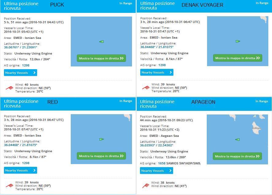
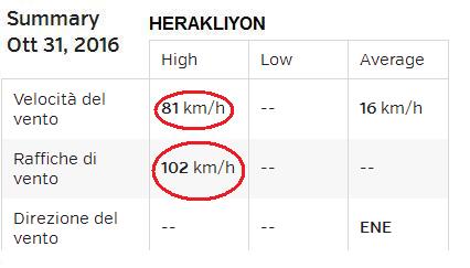
Re: MED: 90M/TRIXI (Trixie) - Tropical Storm
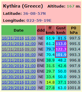
52.9KT GUST
40 KT WIND
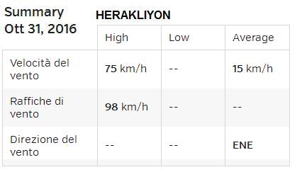
Ships report 40-39kt wind
[b]
40 KT WIND
Ships report 40-39kt wind
[b]
0 likes
-
DanieleItalyRm
- Category 1
- Posts: 486
- Age: 38
- Joined: Mon Sep 22, 2008 7:52 am
- Location: Rome - Italy - Mediterranean sea
-
TheEuropean
- Professional-Met
- Posts: 1793
- Age: 58
- Joined: Tue Sep 20, 2005 3:17 pm
- Location: Voerde, Germany
- Contact:
Re: MED: 90M/TRIXI (Trixie) - Tropical Storm
0 likes
The above post is not official and should not be used as such. It is the opinion of the poster and may or may not be backed by sound meteorological data. It is not endorsed by any professional institution or storm2k.org. For official information, please refer to the NHC and NWS products.
-
wxman57

- Moderator-Pro Met

- Posts: 22480
- Age: 66
- Joined: Sat Jun 21, 2003 8:06 pm
- Location: Houston, TX (southwest)
Re: MED: 90M/TRIXI (Trixie) - Tropical Storm
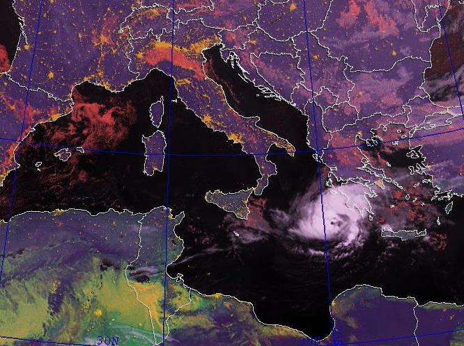
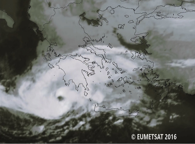
Looks like it has merged with a cold front that extends to southern Greece.
0 likes
-
1900hurricane

- Category 5

- Posts: 6044
- Age: 32
- Joined: Fri Feb 06, 2015 12:04 pm
- Location: Houston, TX
- Contact:
Re: MED: 90M/TRIXI (Trixie) - Tropical Storm
Here's an ASCAT pass from a few hours ago, just before it started to quickly deteriorate.

0 likes
Contract Meteorologist. TAMU & MSST. Fiercely authentic, one of a kind. We are all given free will, so choose a life meant to be lived. We are the Masters of our own Stories.
Opinions expressed are mine alone.
Follow me on Twitter at @1900hurricane : Read blogs at https://1900hurricane.wordpress.com/
Opinions expressed are mine alone.
Follow me on Twitter at @1900hurricane : Read blogs at https://1900hurricane.wordpress.com/
-
TheEuropean
- Professional-Met
- Posts: 1793
- Age: 58
- Joined: Tue Sep 20, 2005 3:17 pm
- Location: Voerde, Germany
- Contact:
Re: MED: 90M/TRIXI (Trixie) - Tropical Storm
1900hurricane wrote:Here's an ASCAT pass from a few hours ago, just before it started to quickly deteriorate.
Thx, I see some 60 kts there, right?
0 likes
The above post is not official and should not be used as such. It is the opinion of the poster and may or may not be backed by sound meteorological data. It is not endorsed by any professional institution or storm2k.org. For official information, please refer to the NHC and NWS products.
-
1900hurricane
- Category 5
- Posts: 6044
- Age: 32
- Joined: Fri Feb 06, 2015 12:04 pm
- Location: Houston, TX
- Contact:
Re: MED: 90M/TRIXI (Trixie) - Tropical Storm
TheEuropean wrote:1900hurricane wrote:Here's an ASCAT pass from a few hours ago, just before it started to quickly deteriorate.
Thx, I see some 60 kts there, right?
It's hard to tell between 55 kt and 60 kt in that image, but yes, there does appear to be a few barbs indicating winds greater than 50 kt.
0 likes
Contract Meteorologist. TAMU & MSST. Fiercely authentic, one of a kind. We are all given free will, so choose a life meant to be lived. We are the Masters of our own Stories.
Opinions expressed are mine alone.
Follow me on Twitter at @1900hurricane : Read blogs at https://1900hurricane.wordpress.com/
Opinions expressed are mine alone.
Follow me on Twitter at @1900hurricane : Read blogs at https://1900hurricane.wordpress.com/
-
TheEuropean
- Professional-Met
- Posts: 1793
- Age: 58
- Joined: Tue Sep 20, 2005 3:17 pm
- Location: Voerde, Germany
- Contact:
Re: MED: 90M/TRIXI (Trixie) - Tropical Storm
1900hurricane wrote:TheEuropean wrote:1900hurricane wrote:Here's an ASCAT pass from a few hours ago, just before it started to quickly deteriorate.
Thx, I see some 60 kts there, right?
It's hard to tell between 55 kt and 60 kt in that image, but yes, there does appear to be a few barbs indicating winds greater than 50 kt.
With better structure a few hours before with a clear eye I go with at least 55 or 60 kt, may be even higher.
0 likes
The above post is not official and should not be used as such. It is the opinion of the poster and may or may not be backed by sound meteorological data. It is not endorsed by any professional institution or storm2k.org. For official information, please refer to the NHC and NWS products.
-
DanieleItalyRm
- Category 1
- Posts: 486
- Age: 38
- Joined: Mon Sep 22, 2008 7:52 am
- Location: Rome - Italy - Mediterranean sea
Re: MED: 90M/TRIXI (Trixie) - Tropical Storm
1900hurricane wrote:TheEuropean wrote:1900hurricane wrote:Here's an ASCAT pass from a few hours ago, just before it started to quickly deteriorate.
Thx, I see some 60 kts there, right?
It's hard to tell between 55 kt and 60 kt in that image, but yes, there does appear to be a few barbs indicating winds greater than 50 kt.
You Can send an email from sab noaa with ascat wind? T2.0 intensity more incorrect.
0 likes
-
1900hurricane
- Category 5
- Posts: 6044
- Age: 32
- Joined: Fri Feb 06, 2015 12:04 pm
- Location: Houston, TX
- Contact:
Re: MED: 90M/TRIXI (Trixie) - Tropical Storm
DanieleItalyRm wrote:1900hurricane wrote:TheEuropean wrote:
Thx, I see some 60 kts there, right?
It's hard to tell between 55 kt and 60 kt in that image, but yes, there does appear to be a few barbs indicating winds greater than 50 kt.
You Can send an email from sab noaa with ascat wind? T2.0 intensity more incorrect.
The Satellite Analysis Branch isn't an agency that will issue full advisories on tropical cyclones. Their only concern is issuing bulletins based solely on the Dvorak Technique. It is up to the agencies warning on tropical cyclones to incorporate all the given data, including ASCAT, and come up with an intensity estimate. Unfortunately, there does not seem to be an agency designated to put out advisories on tropical or subtropical cyclones in the Mediterranean Sea.
0 likes
Contract Meteorologist. TAMU & MSST. Fiercely authentic, one of a kind. We are all given free will, so choose a life meant to be lived. We are the Masters of our own Stories.
Opinions expressed are mine alone.
Follow me on Twitter at @1900hurricane : Read blogs at https://1900hurricane.wordpress.com/
Opinions expressed are mine alone.
Follow me on Twitter at @1900hurricane : Read blogs at https://1900hurricane.wordpress.com/
-
DanieleItalyRm
- Category 1
- Posts: 486
- Age: 38
- Joined: Mon Sep 22, 2008 7:52 am
- Location: Rome - Italy - Mediterranean sea
Re: MED: 90M/TRIXI (Trixie) - Tropical Storm
......
Last edited by DanieleItalyRm on Mon Oct 31, 2016 11:52 am, edited 3 times in total.
0 likes
-
wxman57
- Moderator-Pro Met
- Posts: 22480
- Age: 66
- Joined: Sat Jun 21, 2003 8:06 pm
- Location: Houston, TX (southwest)
Re: MED: 90M/TRIXI (Trixie) - Tropical Storm
I can't find anything on satellite now. Could see the low at 10Z but it has accelerated ENE and is hard to locate now. May not be much left of it.
1 likes
-
DanieleItalyRm
- Category 1
- Posts: 486
- Age: 38
- Joined: Mon Sep 22, 2008 7:52 am
- Location: Rome - Italy - Mediterranean sea
Re: MED: 90M/TRIXI (Trixie) - Tropical Storm
1900hurricane wrote:DanieleItalyRm wrote:1900hurricane wrote:It's hard to tell between 55 kt and 60 kt in that image, but yes, there does appear to be a few barbs indicating winds greater than 50 kt.
You Can send an email from sab noaa with ascat wind? T2.0 intensity more incorrect.
The Satellite Analysis Branch isn't an agency that will issue full advisories on tropical cyclones. Their only concern is issuing bulletins based solely on the Dvorak Technique. It is up to the agencies warning on tropical cyclones to incorporate all the given data, including ASCAT, and come up with an intensity estimate. Unfortunately, there does not seem to be an agency designated to put out advisories on tropical or subtropical cyclones in the Mediterranean Sea.
It's depressing to see current bulletins chase Invest 15-25 kt intensity and ignore a 60KT tropical storm.
If this was located in the Nort west Atlantic it would be well chased.
We are in 2016, every year the same bad story for the Mediterranean systems.
Now 90M dissipated.
I thank all of you for giving attention to this storm.
0 likes

Re: MED: 90M/TRIXI (Trixie) - Tropical Storm
It's happening guys!! So excited to track an official 90M again.
And it's gone before I can enjoy it.
And it's gone before I can enjoy it.
1 likes
-
DanieleItalyRm
- Category 1
- Posts: 486
- Age: 38
- Joined: Mon Sep 22, 2008 7:52 am
- Location: Rome - Italy - Mediterranean sea
Re: MED: 90M/TRIXI (Trixie) - Tropical Storm
I wanted to ask something important
As could be born an official cyclones tracking center for the Mediterranean sea? How can 'solve These conflicts that go on from years? Mediterranean has more many systems of the South Atlantic Ocean; it is obvious That These cyclones are just as TC Karl (nov.1980), TC Vince (oct.2005), TC Grace (oct.2009), TC Chris (jun.2012), TC Alex (january 2016) and many others, all in subtropical latitudine and over sea surface (19-25°C), extratropical or subtropical in origin but become in tropical cyclones.
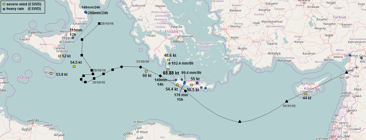
Strong Winds and heavy rains in the 90M transit: In Calabria, South Greece and Crete torrential rains Caused problems. In Additions, the maritime and air transport experienced serious problems for over 24 hours.
Viannos floods (Crete)
https://www.youtube.com/watch?v=D1ngUMKJBRg&feature=youtu.be
Malta sea storm:
https://www.youtube.com/watch?v=PZDJDvJgIjo
http://www.meteoweb.eu/video-gallery/maltempo-ciclone-al-sud-la-tempesta-nella-baia-di-st-julian-a-malta/id/189423733/
As could be born an official cyclones tracking center for the Mediterranean sea? How can 'solve These conflicts that go on from years? Mediterranean has more many systems of the South Atlantic Ocean; it is obvious That These cyclones are just as TC Karl (nov.1980), TC Vince (oct.2005), TC Grace (oct.2009), TC Chris (jun.2012), TC Alex (january 2016) and many others, all in subtropical latitudine and over sea surface (19-25°C), extratropical or subtropical in origin but become in tropical cyclones.
Strong Winds and heavy rains in the 90M transit: In Calabria, South Greece and Crete torrential rains Caused problems. In Additions, the maritime and air transport experienced serious problems for over 24 hours.
Viannos floods (Crete)
https://www.youtube.com/watch?v=D1ngUMKJBRg&feature=youtu.be
Malta sea storm:
https://www.youtube.com/watch?v=PZDJDvJgIjo
http://www.meteoweb.eu/video-gallery/maltempo-ciclone-al-sud-la-tempesta-nella-baia-di-st-julian-a-malta/id/189423733/
0 likes
Who is online
Users browsing this forum: No registered users and 38 guests